


Air Temperatures – The following maximum temperatures (F) were recorded across the state of Hawaii Thursday…along with the minimums Thursday:
78 – 60 Lihue, Kauai
80 – 67 Honolulu, Oahu
80 – 60 Molokai AP
84 – 61 Kahului AP, Maui
82 – 73 Kailua Kona
83 – 67 Hilo AP, Hawaii
Here are the latest 24-hour precipitation totals (inches) for each of the islands, as of Thursday evening:
0.01 Kilohana, Kauai
0.00 Oahu
0.00 Molokai
0.00 Lanai
0.00 Kahoolawe
0.43 West Wailuaiki, Maui
0.43 Saddle Quarry, Big Island
The following numbers represent the strongest wind gusts (mph)…as of Thursday evening:
17 Mana, Kauai – NW
12 Oahu Forest NWR, Oahu – NW
10 Molokai – NE
10 Lanai – NE
13 Kahaloowe – SE
16 Kapalua, Maui – N
17 Upolu AP, Big Island – NE
Hawaii’s Mountains – Here’s a link to the live web cam on the summit of near 13,800 foot Mauna Kea on the Big Island of Hawaii. This web cam is available during the daylight hours here in the islands…and when there’s a big moon shining down during the night at times. Plus, during the nights you will be able to see stars, and the sunrise and sunset too…depending upon weather conditions.
Aloha Paragraphs

Deep storm far north in the Gulf of Alaska…with
a cold front moving by to the north of Hawaii

Scattered thunderstorms far to our southwest

Clear to partly to cloudy…some cloudy areas

A few showers…mostly light and scattered around
the eastern islands – looping radar image
High Surf Advisory…north and west shores of Kauai, Oahu,
Molokai, Big Island, and the north shore of Maui
Severe Drought…State of Hawaii –
A LONG PERIOD OF DRY WEATHER CONDITIONS CAUSED BY THE ONGOING STRONG EL NINO EVENT HAS PRODUCED LARGE AREAS OF DROUGHT ACROSS THE STATE OF HAWAII. OVER THE PAST SEVERAL WEEKS…MODERATE DROUGHT HAS BEEN SPREADING OVER LEEWARD SECTIONS OF ALL THE ISLANDS, AND COVERS MORE THAN HALF OF THE STATE. DROUGHT IMPACTS IN SEVERAL AREAS HAVE REACHED THE SEVERE LEVEL…ON THE BIG ISLAND AND MAUI.
OVER THE NEXT SEVERAL WEEKS…DROUGHT CONDITIONS WILL LIKELY INCREASE IN AREAL COVERAGE AND INTENSITY. PROSPECTS FOR EASING THE DROUGHT IN THE LEEWARD AREAS ARE WANING AS THE STATE HEADS TOWARD THE END OF THE OCTOBER THROUGH APRIL WET SEASON.
~~~ Hawaii Weather Narrative ~~~
Light and variable breezes through Friday, light trades Saturday…then southeast Sunday into next Monday. Here’s the latest weather map, showing the Hawaiian Islands, and the rest of the North Pacific Ocean. We find high pressure systems far northeast and close by to the west-northwest of the state. At the same time, there’s a ridge of high pressure just north of the islands. In addition, there’s numerous low pressure systems to the northeast through northwest of Hawaii. We’ll find generally light winds through the weekend…along with these lighter winds, we’ll see more thick volcanic haze collecting locally at times.
Here’s a wind profile…of the offshore waters around the islands – with a closer view
Here’s the Hawaiian Islands Sulfate Aerosol…animated graphic – showing vog forecast
A few upcountry afternoon showers at times…locally through Friday. The atmosphere over and around the islands remains quite dry and stable, although slightly less so around the Big Island. This in turn will limit the intensity of any shower activity into the weekend…at least in most areas. Looking ahead, the models continue to suggest we could finally see a more robust cold front moving into our area next week. This Tuesday-Wednesday front could bring a good increase in showers statewide. The models go on to point out the chance of a notable period of windy to very windy weather in the wake of that cold front…bringing a late winter chill our way for a day or two.
Marine environment details: The high surf warnings for north and west facing shores from Kauai to Maui have been downgraded to high surf advisories, which have been pushed through the day on Friday. High surf advisories also remain in place on the Big Island through the night. The next northwest swell will arrive on Saturday, with surf possibly reaching warning levels along north and west facing shores of most islands.
Although winds will remain at gentle strength for the next couple of days over most areas, a small craft advisory remains in effect for waters for seas of 10 ft or more in areas exposed to the northwest swell. This advisory should come down later tonight but will be reissued on Saturday for another northwest swell. The next round of significant wind and seas is due behind a front that will move down the island chain Tuesday and Wednesday.

Here in Maui County...It’s clear to partly cloudy early this Thursday morning. Here in upcountry Kula we have an air temperature of 54.8F degrees before sunrise. The temperature at near the same time was 61 degrees down in Kahului under cloudy skies, 68 out in Hana, 70 at Maalaea Bay, and 43 atop the Haleakala summit. Meanwhile, Kahoolawe was 63 degrees, 60 at Lanai City, with 66 at the Molokai airport.
– We’re into the afternoon hours now, under cloud free skies, although with variable amounts of partly to mostly cloudy weather over and around the mountains. And yes, the smokey reality, along with some volcanic haze, are still making for incredibly bad air to be breathing here on Maui! Here at my place in upcountry Kula, it’s totally cloudy, with a few light showers beginning to fall. I was up the mountain this morning, and finally broke out of the smoke and vog near 6,700 feet, which was a relief…to finally find some decent air to breathe. When I drove back down to Kula, I once again had to dip into this polluted air, which wasn’t that pleasant!
– Early evening, nothing has really changed all day…we are still stuck under this heavy lid of smoke and haze!
Meanwhile, we have volcanic haze, and smoke from a sugar cane burn in the central valley, in addition to a brush fire over on the west side early Thursday morning. Personally, I consider this a crime, that the agri-business here on Maui would light a sugar cane field ablaze, adding smoke to our already voggy and smokey atmosphere. This contributes greatly to the already unhealthy air we’re breathing! Shame on them, this is a crime against our vulnerable citizens, ranging from little babies…all the way up into the senior citizen age group! There isn’t anything we can do about the volcanic emissions, they come from a natural source…although the cane smoke, and brush fire on the west side of Maui, are man made, and we can potentially do something about that. If you would like to add your response to this situation, please use the Reply box below.
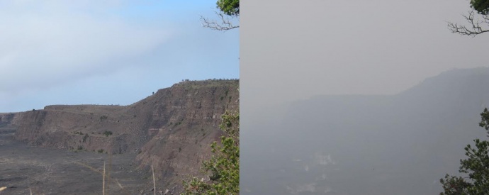
The difference between a clear day, and when volcanic haze…or
smoke is in the air
World-wide tropical cyclone activity:
>>> Atlantic Ocean: The last regularly scheduled Tropical Weather Outlook of the 2015 Atlantic hurricane season…has occurred. Routine issuance of the Tropical Weather Outlook will resume on June 1, 2016. During the off-season, Special Tropical Weather Outlooks will be issued if conditions warrant. Here’s the 2015 hurricane season summary
Here’s a satellite image of the Atlantic Ocean
>>> Caribbean Sea: The last regularly scheduled Tropical Weather Outlook of the 2015 Atlantic hurricane season…has occurred. Routine issuance of the Tropical Weather Outlook will resume on June 1, 2016. During the off-season, Special Tropical Weather Outlooks will be issued if conditions warrant.
>>> Gulf of Mexico: The last regularly scheduled Tropical Weather Outlook of the 2015 Atlantic hurricane season…has occurred. Routine issuance of the Tropical Weather Outlook will resume on June 1, 2016. During the off-season, Special Tropical Weather Outlooks will be issued if conditions warrant.
Here’s a satellite image of the Caribbean Sea…and the Gulf of Mexico
Here’s the link to the National Hurricane Center (NHC)
>>> Eastern Pacific: The last regularly scheduled Tropical Weather Outlook of the 2015 North Pacific hurricane season…has occurred. Routine issuance of the Tropical Weather Outlook will resume on May 15, 2016. During the off-season, Special Tropical Weather Outlooks will be issued if conditions warrant. Here’s the 2015 hurricane season summary
Here’s a wide satellite image that covers the entire area between Mexico, out through the central Pacific…to the International Dateline.
Here’s the link to the National Hurricane Center (NHC)
>>> Central Pacific: The central north Pacific hurricane season has officially ended. Routine issuance of the tropical weather outlook will resume on June 1, 2016. During the off-season, special tropical weather outlooks will be issued if conditions warrant. Here’s the 2015 hurricane season summary
Here’s a link to the Central Pacific Hurricane Center (CPHC)
>>> South Pacific Ocean: There are no active tropical cyclones
>>> North and South Indian Oceans / Arabian Sea: There are no active tropical cyclones
Here’s a link to the Joint Typhoon Warning Center (JTWC)
Interesting: Can you guess the world’s longest distance flyer? – A dragonfly barely an inch and a half long appears to be animal world’s most prolific long distance traveler – flying thousands of miles over oceans as it migrates from continent to continent – according to newly published research.
Biologists at Rutgers University-Newark (RU-N) who led the study – which appears in the journal PLOS ONE – say the evidence is in the genes. They found that populations of this dragonfly, called Pantala flavescens, in locations as far apart as Texas, eastern Canada, Japan, Korea, India, and South America, have genetic profiles so similar that there is only one likely explanation. Apparently – somehow – these insects are traveling distances that are extraordinarily long for their small size, breeding with each other, and creating a common worldwide gene pool that would be impossible if they did not intermingle.
“This is the first time anyone has looked at genes to see how far these insects have traveled,” says Jessica Ware, an assistant professor of biology on the faculty of RU-N’s College of Arts and Sciences and senior author of the study. “If North American Pantala only bred with North American Pantala, and Japanese Pantala only bred with Japanese Pantala,” Ware says, “we would expect to see that in genetic results that differed from each other. Because we don’t see that, it suggests the mixing of genes across vast geographic expanses.”
But how do insects from different continents manage to meet and hook up? These are not large birds or whales that one would expect to travel thousands of miles. Ware says it appears to be the way their bodies have evolved. “These dragonflies have adaptations such as increased surface areas on their wings that enable them to use the wind to carry them. They stroke, stroke, stroke and then glide for long periods, expending minimal amounts of energy as they do so.”
Dragonflies, in fact, have already been observed crossing the Indian Ocean from Asia to Africa. “They are following the weather,” says Daniel Troast, who analyzed the DNA samples in Ware’s lab while working toward his master’s degree in biology, which he earned at the university in 2015. “They’re going from India where it’s dry season to Africa where it’s moist season, and apparently they do it once a year.”
Moisture is a must for Pantala to reproduce, and that, says Ware, is why these insects would be driven to even attempt such a perilous trip, which she calls a “kind of suicide mission.” The species depends on it. While many will die en route, as long as enough make it, the species survives.
Flight patterns appear to vary. The hardiest of the dragonflies might make the trip nonstop, catching robust air currents or even hurricane winds and gliding all the way. Others may, literally, be puddle jumpers. Pantala need fresh water to mate and lay their eggs – and if while riding a weather current they spot a fresh water pool created by a rainstorm – even on an island in the middle of a vast ocean – Ware and Troast say it’s likely they dive earthward and use those pools to mate. After the eggs hatch and the babies are mature enough to fly – which takes just a few weeks – the new dragonflies join the swarm’s intercontinental and now multi-generational trek right where their parents left off.
For the moment, the details of this extraordinary insect itinerary are an educated best guess, as are specific routes these migrations might take. Much more work is needed to bring many loose ends together. But now that their work has established a worldwide population of intermingling dragonflies, Ware and Troast hope that scientists can work on plotting those routes in earnest. They would need to be innovative, because tracking devices that can be attached to larger animals are far too big to put on insects.
What the Rutgers scientists have discovered puts this dragonfly far ahead of any identified insect competitor. “Monarch butterflies migrating back and forth across North America were thought to be the longest migrating insects,” traveling about 2,500 miles each way, says Troast, “but Pantala completely destroys any migrating record they would have,” with its estimated range of 4,400 miles or more. It also exceeds Charles Lindbergh’s celebrated solo flight from New York to Paris by at least several hundred miles.
Pantala leaves many of its fellow dragonflies even farther behind. The mysteries of evolution are such that while Pantala and its cousin the Green Darner (Anax junius) have developed into world travelers, Ware says that by contrast, other members of the family “don’t ever leave the pond on which they’re born – traveling barely 36 feet away their entire lives.”
Linda Says:
For the first time my lungs hurt today. It’s difficult to take a deep breath.
Money overrules health and well being for us all.
Time to take a stand. Thank you Glenn for doing it.
~~~ Hi Linda, thanks for providing your valuable feedback as well. Yes, when the environment gets this out of whack, there’s no choice but to say something!
Aloha, Glenn
Yvette Says:
Retired and decided to give Maui a try.
Won’t be staying.
Burning cane when the leaves could be
used as fuel for the sugar making process?
A waste of resources.
Attacking residents when they complain?
Rude and Disrespectful
Breathing the cane smoke and not
Complaining. Just plain stupid.
Aloha.
~~~ Hi Yvette, can certainly understand your point of view. It’s an issue and a problem that Maui has been dealing with for a long time. Apparently, although I’m not positive about this, this agri-business will be discontinuing their sugar cane burning by the end of this year.
There certainly has been lots of complaining over the years, believe me! I’m sorry you ran into this issue.
Aloha, Glenn
Glenn Says:
Aloha. I know the last time I visited the vog was very bad the last few days of vacation. I’m glad that the cane industry will be shutting down at the end of the year. I have to laugh at a lot of locals lamenting the loss of a way of life when it ends. They say it is the Hawaiian way to grow cane. The reality is that the first cane processing plant was built less than a hundred years ago. They need to study their history a bit more before complaining about the loss of their “culture”!!! Hope the air clears so you can continue your jaunts up the road.
Aloha, Glenn in South Jersey
~~~ Hi Glenn, good to hear from you again! As a matter of fact, I went up the mountain today, not only to commune with nature and exercise…but to escape the terrible vog conditions!
As I was driving down the mountain, from the 7,000 foot elevation, I could hardly believe my eyes, at how thick this volcanic haze is today!
Thanks for your reply my friend…
Aloha, Glenn
Mary O Dixon Says:
Glenn, I cannot agree more! I’ve lived here eight years. We moved here because my husband suffers from emphysema, and I have asthma. Naturally, we thought the most remote islands in the world would have the freshest air. Paid taxes, own my home, had a child in school here, volunteer for our community. When I started fighting the burn, I was subjected to the kind of insults and racism I never expected, such as “Haole, go home!” And “If you don’t like it, leave. Nobody wants you here anyway.”
This has NOTHING to do with where a person was born, or what the history of the islands is. What it’s about is an outdated, illegal, insane practice that has been tolerated for far too long.
Today, I would have had a rough time because of the vog, but I would have walked my dog and gone swimming for exercise. With the burn, those activities are out of the question.
How in the world does a corporation get to decide whether I get to breathe today, or not?
Roz Baker wrote me personally to describe the cane burn as nothing more than a nuisance, and that jobs and keeping A&B running was her priority. When I fired back that it was far more than a mere NUISANCE to those of us struggling to breathe she suggested we consider relocating. It was only slightly more polite than the “Haole, go home” insults.
All of the expensive and time consuming efforts of the Ban the Burn group have been put off time and time again by the courts.
It’s INSANE.
~~~ Hello again Mary, good to hear from you, although I can certainly feel and understand your anger! I totally agree with you, there is no good enough reason to burn the cane, when there are other ways of harvesting this sugar.
I’m surprised at Roz Baker’s response, that sounds like polite nastiness to me.
I’ll keep you informed at how this vog situation is, and like I was telling Glenn in his reply, today’s is one of the worst volcanic haze days I’ve ever seen in the 41 years that I’ve lived in the islands!
Aloha, Glenn
Douglas MacDougal Says:
Hi Glen
Burning cane evolved 150 years ago when the growers needed to clear the fields to give access to the many men who cut it by hand. There are now machines that do this work and burning is not required! They cut it green is the expression used. Burning was phased out here in Australia many years ago.
No Excuses !
Aloha
Douglas
~~~ Hi Douglas, good to hear from you, and thanks for your personal response to this nasty situation.
I think you hit the nail right on the head…there is no excuse for making our atmosphere unhealthy by burning sugar cane! The vog is something we can’t control, although burning the cane sure is.
Thanks for writing all the way from Australia.
Aloha, Glenn