


Air Temperatures – The following maximum temperatures (F) were recorded across the state of Hawaii Thursday…along with the minimums Thursday:
76 – 65 Lihue, Kauai
82 – 63 Honolulu, Oahu
80 – 67 Molokai AP
81 – 68 Kahului AP, Maui
79 – 69 Hilo AP, Hawaii
Here are the latest 24-hour precipitation totals (inches) for each of the islands, as of Thursday evening:
0.99 Kilohana, Kauai
0.26 Poamoho RG 1, Oahu
0.50 Puu Alii, Molokai
0.00 Lanai
0.00 Kahoolawe
1.36 West Wailuaiki, Maui
0.56 Saddle Quarry, Big Island
The following numbers represent the strongest wind gusts (mph)…as of Thursday evening:
27 Port Allen, Kauai – NE
31 Kuaokala, Oahu – NE
22 Molokai – N
24 Lanai – NE
31 Kahaloowe – NE
28 Kapalua, Maui – NNE
25 Kealakomo, Big Island – NE
Hawaii’s Mountains – Here’s a link to the live web cam on the summit of near 13,800 foot Mauna Kea on the Big Island of Hawaii. This web cam is available during the daylight hours here in the islands…and when there’s a big moon shining down during the night at times. Plus, during the nights you will be able to see stars, and the sunrise and sunset too…depending upon weather conditions.
Aloha Paragraphs

A large storm is spinning far north in the Gulf of Alaska…
while sending a quickly dissipating cold front into the tropics

A cold front has crossed Kauai…and is falling apart

Partly to mostly cloudy skies across the state…especially along
the windward sides of the Big Island and Maui

Showers mostly offshore to the southeast of the Big Island…as well
as the windward sides of the other islands – looping radar image
High Surf Warning…along north and west shores of Kauai, Oahu,
Molokai, and the Big Island…and the north shore of Maui
High Surf Advisory…along west shore of Maui
Small Craft Advisory…coasts and channels statewide
~~~ Hawaii Weather Narrative ~~~
Trade winds continuing into the weekend. Here’s the latest weather map, showing the Hawaiian Islands, and the rest of the North Pacific Ocean. We find high pressure systems east-northeast, north, and west-northwest of Hawaii. In addition, there’s a low pressure system far to the northeast of Hawaii. This gale low pressure system has sent a weak cold front in our direction, although it has fallen apart for the most part. The trade winds picked up in strength today, as a new high pressure system moves into range to the north. These trades will remain active through Saturday night, and then become lighter Sunday into Monday. A cold front moves through the state Monday, perhaps even two…with chilly northerly winds returning in their wake briefly. The way things have been going, we could see another cold front or even two approaching later next week.
Here’s a wind profile…of the offshore waters around the islands – with a closer view
Here’s the Hawaiian Islands Sulfate Aerosol…animated graphic – showing vog forecast
A weak cold front will continue to bring some showers to the western islands…with the trades bringing some windward showers to the eastern islands. The returning trade winds will carry remnant moisture from a previous cold front…up along the eastern islands, as they are doing at this time. The combination of these two moisture sources will keep windward showers falling, in an off and on manner into the early part of the weekend. The latest models continue showing a couple of cold fronts arriving early next week, bringing another round of showers to our area for a day or two then. The returning winds behind that front, will bring cool conditions and potentially a few more showers our way into the middle of next week.
Special Surf Statement: A very large warning level northwest swell continues to pound the north and west facing shores, which will lower gradually Friday into Saturday. Wave heights are expected to be similar to the recent extra large northwest swell, and will again make for very dangerous conditions along those exposed beaches. Please use extreme caution when going near many of our beaches into early in the upcoming weekend! A new advisory level northwest swell will fill in Saturday night, peak on Sunday, then lower gradually Sunday night into next Monday. Yet another large northwest swell will gradually fill in late Monday and Monday night with its expected peak next Tuesday.

Here in Maui County…It’s clear to cloudy early this Thursday morning. Here in upcountry Kula we have an air temperature of 45.8F degrees well before sunrise. The temperature at near the same time was 68 degrees down in Kahului with light rain, 66 out in Hana also with light rain, and 43 degrees up at the summit of the Haleakala Crater. Meanwhile, Kahoolawe was 70 degrees, 64 at Lanai City, with 67 at the Molokai airport. / Now at 9am, it’s mostly clear and sunny, with some fairly minor clouds along the windward sides.
– It’s getting towards the middle of the afternoon, with mostly clear skies prevailing, with clouds banked-up against the mountains…and along the windward coasts too.
– Partly cloudy in general, although with just a few showers here and there.
I’ll be back with many more updates on all of the above and below, I hope you have a great Thursday night wherever you’re spending it! Aloha for now…Glenn
World-wide tropical cyclone activity:
>>> Atlantic Ocean: The last regularly scheduled Tropical Weather Outlook of the 2015 Atlantic hurricane season…has occurred. Routine issuance of the Tropical Weather Outlook will resume on June 1, 2016. During the off-season, Special Tropical Weather Outlooks will be issued if conditions warrant. Here’s the 2015 hurricane season summary
Here’s a satellite image of the Atlantic Ocean
>>> Caribbean Sea: The last regularly scheduled Tropical Weather Outlook of the 2015 Atlantic hurricane season…has occurred. Routine issuance of the Tropical Weather Outlook will resume on June 1, 2016. During the off-season, Special Tropical Weather Outlooks will be issued if conditions warrant.
>>> Gulf of Mexico: The last regularly scheduled Tropical Weather Outlook of the 2015 Atlantic hurricane season…has occurred. Routine issuance of the Tropical Weather Outlook will resume on June 1, 2016. During the off-season, Special Tropical Weather Outlooks will be issued if conditions warrant.
Here’s a satellite image of the Caribbean Sea…and the Gulf of Mexico
Here’s the link to the National Hurricane Center (NHC)
>>> Eastern Pacific: The last regularly scheduled Tropical Weather Outlook of the 2015 North Pacific hurricane season…has occurred. Routine issuance of the Tropical Weather Outlook will resume on May 15, 2016. During the off-season, Special Tropical Weather Outlooks will be issued if conditions warrant. Here’s the 2015 hurricane season summary
Here’s a wide satellite image that covers the entire area between Mexico, out through the central Pacific…to the International Dateline.
Here’s the link to the National Hurricane Center (NHC)
>>> Central Pacific: The central north Pacific hurricane season has officially ended. Routine issuance of the tropical weather outlook will resume on June 1, 2016. During the off-season, special tropical weather outlooks will be issued if conditions warrant. Here’s the 2015 hurricane season summary
Here’s a link to the Central Pacific Hurricane Center (CPHC)
>>> South Pacific Ocean:
Tropical Cyclone 14P (Yalo) is now dissipating in the Southwest Pacific Ocean, located 359 NM south of Papeete, Tahiti, with sustained winds of 40 mph…with gusts to 52 mph. Here’s the JTWC graphical track map, along with a satellite image of this system – Final Warning
>>> North and South Indian Oceans / Arabian Sea: There are no active tropical cyclones
Here’s a link to the Joint Typhoon Warning Center (JTWC)
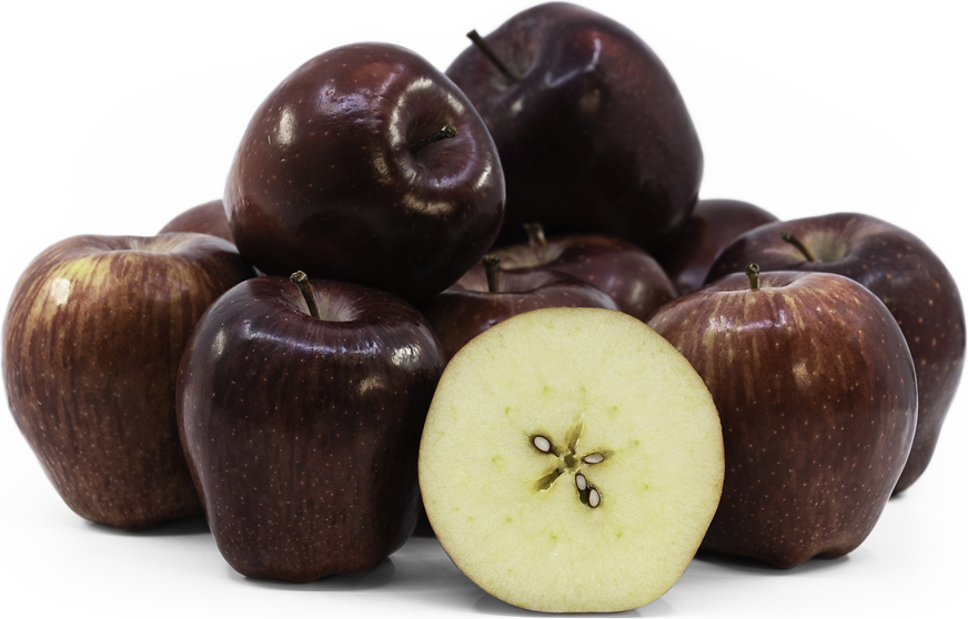
Interesting: What happened to the Red Delicious apple – If you’re like most people, when looking for apples among the plethora of offerings at your local supermarket, perhaps you choose the most visually appealing.
You may have noticed that in comparison with varieties that may be smaller, slightly mottled or have a brown spot or two, the Red Delicious easily wins the blue ribbon for best looking.
Your first bite, however, might remind you that apples are one more thing you can’t judge by first appearances. The gorgeous apple that for 70 years was everybody’s first choice for lunchboxes and teachers’ desks has literally fallen by the wayside.
While they look fantastic in a fruit basket, Red Delicious apples are usually the last ones to be eaten, if eaten at all. For quite a while, most kids didn’t even know what an apple was supposed to taste like.
“What happened?” you might ask.
It was America’s captivation with flawless perfection that drove ambitious horticulturists of the early 20th century to relentlessly, collectively and literally breed this popular apple variety out of existence. It’s a story with a lesson for us all.