


Air Temperatures – The following maximum temperatures were recorded across the state of Hawaii Monday:
Lihue, Kauai – 82
Honolulu airport, Oahu – 85
Kaneohe, Oahu – 85
Molokai airport – 82
Kahului airport, Maui – 86 (Record high temperature for Monday / 94 -1951)
Kona airport – 85
Hilo airport, Hawaii – 81
Air Temperatures ranged between these warmest and coolest spots near sea level – and on the highest mountain top around the state…as of 5pm Monday evening:
Barking Sands, Kauai – 82
Hilo, Hawaii – 73
Haleakala Summit – M (near 10,000 feet on Maui)
Mauna Kea Summit – 37 (near 13,800 feet on the Big Island)
Hawaii’s Mountains – Here’s a link to the live web cam on the summit of near 13,800 foot Mauna Kea on the Big Island of Hawaii. This web cam is available during the daylight hours here in the islands…and when there’s a big moon shining down during the night at times. Plus, during the nights you will be able to see stars, and the sunrise and sunset too…depending upon weather conditions. Here's the Haleakala Crater webcam on Maui…although this webcam is not always working correctly.
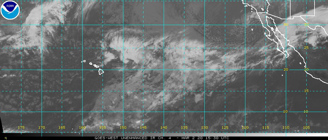
Tropical Cyclone activity in the eastern and central Pacific – Here’s the latest weather information coming out of the National Hurricane Center, covering the eastern north Pacific. You can find the latest tropical cyclone information for the central north Pacific (where Hawaii is located) by clicking on this link to the Central Pacific Hurricane Center. A satellite image, which shows the entire ocean area between Hawaii and the Mexican coast…can be found here.
Aloha Paragraphs


![]()
Gusty trade winds continue, windward
showers at times…a few elsewhere
Winds increasing some later Friday into
the weekend…along with showers locally
Satellite image showing Hawaii in relation to weakening
hurricane Daniel & strengthening category 3 hurricane
Emilia…both in the eastern Pacific
Additional information below –
As this weather map shows, we have high pressure systems spread out from the far northwest, through the northeast of the islands. Our local winds will remain active from the trade wind direction through the next week…potentially quickening Friday into Saturday as former tropical cyclone Daniel moves by south of the Big Island.
The following numbers represent the most recent top wind gusts (mph), along with directions as of Monday evening:
31 Lihue, Kauai – NE
32 Kuaokala, Oahu – NNE
31 Molokai – NE
38 Kahoolawe – NE
36 Kahului, Maui – NE
35 Lanai – NE
39 Pali 2, Big Island – NE
We can use the following links to see what’s going on in our area of the north central Pacific Ocean. Here's the latest NOAA satellite picture – the latest looping satellite image…and finally the latest looping radar image for the Hawaiian Islands.
Here are the latest 24-hour precipitation totals (inches) for each of the islands as of Monday evening:
0.79 Kilohana, Kauai
0.10 Oahu Forest NWR, Oahu
0.12 Molokai
0.00 Lanai
0.00 Kahoolawe
0.36 Puu Kukui, Maui
1.31 Kawainui Stream, Big Island
Sunset Commentary:
Our typical trade wind weather pattern will prevail, breaking down some towards later Friday into the weekend…as former hurricane Daniel moves by to our south. The trade winds remain strong enough today to keep small craft wind advisories active across those windiest channels and coastal areas around the state…from Maui County down through the Big Island. These trade winds will carry some windward biased showers our way periodically…most generously during the night and morning hours. A few of these showers will be carried over into leeward sides at times locally. There will be a change in our weather conditions later this week, with increasing showers, potentially becoming quite generous around Friday into Saturday…as former tropical cyclone Daniel moves by to the south of the state.
As this satellite image shows, we have the usual scattered cumulus and stratocumulus clouds upstream to the east and northeast of the islands. These low level clouds will continue to drop occasional showers along our windward sides as they arrive. Meanwhile, there continues to be a southwest to northeast oriented streak of high cirrus clouds over the ocean, to the south through east and northeast of the Big Island. Here's a closer look at our islands using this satellite picture…so we can keep track of those clouds upstream of the islands…as well as that high cirrus streak moving towards the northeast on the high altitude wind flow.
Here in Kula, Maui at 515pm, it was partly cloudy…with an air temperature of 72.9F degrees. As noted above, our trade winds will continue blowing well into the future. The overall weather picture here in the islands remains generally quite typical for this time of year. Nothing unusual happening here in our latitudes of the tropics of the central Pacific, which will remain the case until quickly weakening tropical cyclone Daniel, moves into our part of the central Pacific basin early Wednesday morning
~~~ We have weakening category 1 hurricane Daniel to our east, and strengthening category 3 hurricane Emilia further east than that…closer to Mexico. Concentrating on Daniel, it will continue churning its way westward, although continues on a definite weakening trend. It will pass into our central Pacific as a tropical depression early Wednesday morning, then passing by well to the south of the Hawaiian Islands later Friday into Saturday…as a remnant low pressure system.
At this point it looks like former Daniel could bring tropical moisture into our area late Thursday into Saturday morning, as the remnants of this system passes by to the south of our islands. I'll track this situation during the week, and we'll fine tune the chances of increased rainfall as we go. This weakening low pressure system could prompt stronger trade winds over our islands Friday and Saturday too. Here's a looping satellite image of hurricanes Daniel and Emilia. Emilia will turn out to be the strongest of these two systems by far, moving into category 4 hurricane status Tuesday…with wind gusts to 167 mph! Interestingly enough, we now have a new tropical disturbance that's trying to become a tropical depression offshore from southern Mexico, with a medium 40% chance of that happening now. There's more information about all of this just below.
~~~ I'll be back again early Tuesday morning with more local weather updates, and with more information about the tropical cyclones to our east as well. I hope you have a great Monday night wherever you happen to be spending it! Aloha for now…Glenn.
[World-wide tropical cyclone activity:
Central Pacific Ocean: There are no active tropical cyclones
Eastern Pacific Ocean: Tropical storm Daniel (4E) is active about 1350 miles east of Hilo, Hawaii…with 76 mph sustained winds. Here's the official NHC graphical track map. Here's a satellite image of this tropical cyclone, and strengthening hurricane Emilia described in the paragraph below. As we see, Daniel will continue migrating west over open ocean in the eastern Pacific today. Daniel has dropped back down into a tropical storm, and forecast to weaken further to a tropical depression not long after it gets into our central Pacific…at which point it will still be well to the east-southeast of our Hawaiian Islands. It then becomes a post tropical remnant low pressure system thereafter, thus losing the rest of its wind circulation to the southeast of the Big Island early Thursday. There's a chance that the northern fringe of whatever clouds and showers, from what will then be retired tropical cyclone Daniel, will move over parts of the state, as it passes by to the south of the Big Island…later Friday into the weekend.
Meanwhile, the 5th tropical cyclone in the eastern Pacific remains active, called hurricane Emilia (5E), located approximately 685 miles south-southwest of the southern tip of Baja California…with 130 mph sustained winds. This powerful category 4 hurricane remains a major hurricane, and will stay that way through most of Wednesday, and thereafter begin losing some strength as it moves in a west-northwest direction. At this point it's forecast to drop back into the tropical storm category late in the day Friday. It's still to early to know for sure, although there's a chance of this, then weakened system, bringing some rainfall to our area, probably without the winds however, at some point later next week. Here's the official NHC graphical track map. Here's a satellite image showing both Daniel and Emilia in the eastern Pacific. Here's what the hurricane models are showing for Emilia.
Finally, CLOUDINESS AND SHOWERS ASSOCIATED WITH A BROAD LOW PRESSURE SYSTEM LOCATED SEVERAL HUNDRED MILES SOUTH OF ACAPULCO MEXICO HAVE CHANGED LITTLE IN ORGANIZATION OVER THE PAST SEVERAL HOURS. CONDITIONS APPEAR CONDUCIVE FOR SLOW DEVELOPMENT OF THIS DISTURBANCE OVER THE NEXT FEW DAYS AS IT MOVES WEST-NORTHWESTWARD NEAR 10 MPH. THIS SYSTEM HAS A MEDIUM CHANCE…40 PERCENT…OF BECOMING A TROPICAL CYCLONE DURING THE NEXT 48 HOURS.
ELSEWHERE…TROPICAL CYCLONE FORMATION IS NOT EXPECTED DURING THE NEXT 48 HOURS.
Atlantic Ocean/Gulf of Mexico/Caribbean: There are no active tropical cyclones
Western Pacific Ocean: There are no active tropical cyclones
South Pacific Ocean: There are no active tropical cyclones
South and North Indian Oceans: There are no active tropical cyclones
Interesting: New findings have emerged in the field of sunburns, the painful yet protective immune response from ultraviolet (UV) radiation. The skin turns reddish and becomes hot to the touch, making it very uncomfortable. UV radiation can also cause general fatigue, mild dizziness, and possible skin diseases.
A new study from the University of California (UC) San Diego has found that the sunburn is actually a consequence of RNA damage to skin cells. This finding may possibly lead to new treatments for blocking the inflammatory process, plus a range of other medical conditions.
"For example, diseases like psoriasis are treated by UV light, but a big side effect is that this treatment increases the risk of skin cancer," said principal investigator Richard L. Gallo, MD, PhD, professor of medicine at UC San Diego School of Medicine and Veterans Affairs San Diego Healthcare System.
"Our discovery suggests a way to get the beneficial effects of UV therapy without actually exposing our patients to the harmful UV light. Also, some people have excess sensitivity to UV light, patients with lupus, for example. We are exploring if we can help them by blocking the pathway we discovered."
The researchers used both human skin cells and a mouse model. They found that UVB radiation fractures and tangles parts of micro-RNA. Typical RNA is responsible for the production of protein, but this special type of RNA is not. The affected cells then release this altered RNA, causing neighboring cells to start a process resulting in an inflammatory response.
This biological response is intended to remove the sun-damaged cells. The individual feels this mechanism and the pain it produces, and sees it as a sunburn. "The inflammatory response is important to start the process of healing after cell death," said Gallo. "We also believe the inflammatory process may clean up cells with genetic damage before they can become cancer.
Of course, this process is imperfect and with more UV exposure, there is more chance of cells becoming cancerous." Other factors influence the effects of sunburn, including gender, skin pigmentation, and individual genetics.
This research has been published in the journal, Nature Medicine
Holly Says:
Aloha Glenn! I'm slowly learning about Hawaii weather and Hurricane forecasting (transplant from St. Louis). On the Hurricane models do the forecasters lean towards one model or do they take an average of all of them? Mahalo for your time! ~~~ Hi Holly, that’s a good question. NWS forecasters use lots of available models, and favor ones that have good continuity, and are especially reliable. I’m not an NWS or JTWC forecaster, so I’d invite one of them to weigh in here, and let us know their experience with hurricane models. Aloha, Glenn
Jeff King Says:
Aloha Glenn,
I may be getting old – but I still have at least a few memory modules. The current "Daniel" is, in fact, the seventh time there's been a "Daniel" since 1978.
I recall the day 2000's Daniel grazed Maui. A group of us were out in our wa'a (six-person outrigger paddling canoe), snorkeling. Floating along off Sugar Beach, the clouds seemed huge and fast, Wailuku Heights was obscured by the downpours and I had visions of Haiku and Pa'ia washing away.
OK, enough memory lane. I have a question: with hurricanes as tightly bunched as are Daniel and Emilia…does the proximity to each other make a difference? Is it like "drafting" in NASCAR, or the opposite where the following storm would serve more as a "ball and chain" and sap the energy in front of it?
Keep up the great work. Jeff~~~Hi Jeff, yes good old Daniel has been around the block a few times before. As for these tropical cyclones getting too close together, and sapping each others energy, called the Fujiwara effect…that isn’t happening now. It doesn’t appear that this will be happening with the next new tropical cyclone, if it generates closer to Mexico than Emilia is now. There seems to be sufficient distancing between these storms that they are finding what they need to strengthen…at least that’s what Emilia will do over the next few days. Good question Jeff, thanks! Aloha, Glenn