


Air Temperatures – The following maximum temperatures were recorded across the state of Hawaii Tuesday:
Lihue, Kauai – 83
Honolulu airport, Oahu – 84
Kaneohe, Oahu – 81
Molokai airport – 79
Kahului airport, Maui – 87 (Record high temperature for Tuesday / 93 -1951)
Kona airport – 84
Hilo airport, Hawaii – 80
Air Temperatures ranged between these warmest and coolest spots near sea level – and on the highest mountain top around the state…as of 6pm Tuesday evening:
Barking Sands, Kauai – 83
Hilo, Hawaii – 76
Haleakala Summit – M (near 10,000 feet on Maui)
Mauna Kea Summit – 43 (near 13,800 feet on the Big Island)
Hawaii’s Mountains – Here’s a link to the live web cam on the summit of near 13,800 foot Mauna Kea on the Big Island of Hawaii. This web cam is available during the daylight hours here in the islands…and when there’s a big moon shining down during the night at times. Plus, during the nights you will be able to see stars, and the sunrise and sunset too…depending upon weather conditions. Here's the Haleakala Crater webcam on Maui…although this webcam is not always working correctly.
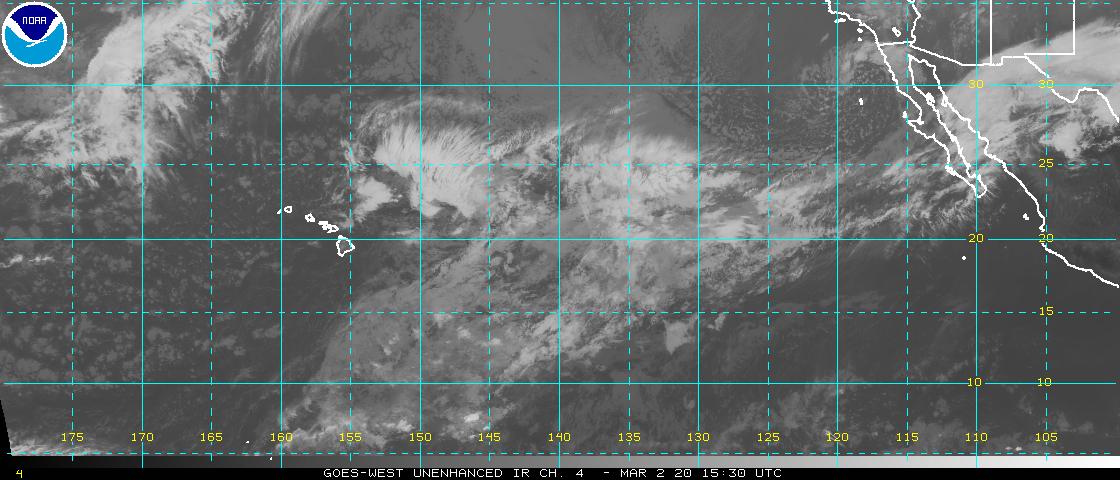
Tropical Cyclone activity in the eastern and central Pacific – Here’s the latest weather information coming out of the National Hurricane Center, covering the eastern north Pacific. You can find the latest tropical cyclone information for the central north Pacific (where Hawaii is located) by clicking on this link to the Central Pacific Hurricane Center. A satellite image, which shows the entire ocean area between Hawaii and the Mexican coast…can be found here.
Aloha Paragraphs

![]()

Gusty trade winds continue, windward
showers at times…a few elsewhere
High surf advisory starting at midnight
for the east shores of the Big Island…
generated by tropical cyclone Daniel
Winds increasing later Thursday into Friday
night…along with generous passing showers
Additional information on tropical cyclones Daniel & Emilia below
As this weather map shows, we have high pressure systems spread out from the far northwest, through the northeast of the islands. Our local winds will remain active from the trade wind direction through the next week…quickening later Thursday into Saturday morning as former tropical cyclone Daniel moves by south of the island chain.
The following numbers represent the most recent top wind gusts (mph), along with directions as of Tuesday evening:
28 Port Allen, Kauai – NE
42 Kuaokala, Oahu – NE
32 Molokai – NE
33 Kahoolawe – NE
38 Kahului, Maui – NE
39 Lanai – NE
40 PTA Keamuku, Big Island – ENE
We can use the following links to see what’s going on in our area of the north central Pacific Ocean. Here's the latest NOAA satellite picture – the latest looping satellite image…and finally the latest looping radar image for the Hawaiian Islands.
Here are the latest 24-hour precipitation totals (inches) for each of the islands as of Tuesday evening:
0.73 Kilohana, Kauai
0.46 Oahu Forest NWR, Oahu
0.36 Molokai
0.00 Lanai
0.00 Kahoolawe
0.78 Puu Kukui, Maui
0.54 Kawainui Stream, Big Island
Sunset Commentary:
Our typical trade wind weather pattern will prevail, breaking down later Thursday into the early part of the weekend…as (then former) tropical storm Daniel moves by to our south. The trade winds remain strong enough today to keep small craft wind advisories active across those windiest channels and coastal areas…from Maui County down through the Big Island. These trade winds will carry some windward biased showers our way periodically…most generously during the night and morning hours. A few of these showers will be carried over into leeward sides at times locally. There will be a change in our weather conditions starting later Thursday, with increasing showers, potentially becoming quite generous for a time into Friday night…as the northern fringe of tropical moisture, from former tropical cyclone Daniel moves by to the south of the state.
As this satellite image shows, we have the usual scattered cumulus and stratocumulus clouds upstream to the east and northeast of the islands. These low level clouds will continue to drop fairly regular showers along our windward sides as they arrive. Meanwhile, there continues to be high cirrus clouds over the ocean, and the islands in places too…especially around the Big Island and Maui. We can now also see tropical storm Daniel a little over 1000 miles to the east-southeast of the Big Island this evening. Here's a closer look at our islands using this satellite picture…so we can keep track of those few showery clouds upstream of the islands tonight. The approach of tropical clouds and showers out ahead of…and to the north of the center of weakening tropical storm Daniel, will come into the picture soon too.
Here in Kula, Maui at 510pm, it was partly cloudy…with an air temperature of 70.7F degrees. As noted above, our trade winds will continue blowing. These winds will remain moderately strong, with locally stronger gusts through mid-week. They should accelerate later Thursday into the early part of the weekend. The overall weather picture here in the islands remains generally quite typical for July…at the moment at least. These environmental conditions will remain in place until…what will then be former Daniel's influences arrive. Tropical cyclone Daniel is forecast to move into the central Pacific basin early Wednesday morning as a weakening tropical depression. High surf generated from tropical cyclone Daniel is forecast to arrive Wednesday morning…which has triggered a high surf advisory on the Big Island's east facing shores starting at midnight.
At this point it looks like (what will then be) former Daniel will bring lots of tropical moisture into our area later Thursday into Friday night, as the fading circulation center of this system passes by well to the south of our islands. This weakening low pressure system will likely prompt stronger trade winds over our islands then as well…along with rising easterly swell. Here's a looping satellite image of tropical storm Daniel and hurricane Emilia. Emilia is still being rated as a category 2 hurricane at the moment…with wind gusts reaching 127 mph at the time of this writing. We continue to have a tropical disturbance that's trying to become a tropical depression offshore from southern Mexico, with a high 80% chance of that happening soon too. There's more information about all of this just below.
~~~ I'll be back again early Wednesday morning with more local weather updates, and with more information about the tropical cyclones to our east-southeast as well. I hope you have a great Tuesday night wherever you happen to be spending it! Aloha for now…Glenn.
[World-wide tropical cyclone activity:
Central Pacific Ocean: There are no active tropical cyclones
Eastern Pacific Ocean: Weakening Tropical storm Daniel (4E) is active about 960 miles east-southeast of Hilo, Hawaii…with 40 mph sustained winds. Here's the official NHC graphical track map. Here's a satellite image of this tropical cyclone, and category 2 hurricane Emilia described in the paragraph below. As we can see, Daniel will continue migrating west over open ocean, now in the central Pacific. Daniel remains a weakening tropical storm, and will weaken further into a tropical depression today…at which point it will still be well to the east-southeast of our Hawaiian Islands. It then becomes a post tropical remnant low pressure system thereafter, thus losing most of its wind circulation to the southeast of the Big Island Thursday. There's a good chance that the northern fringe of its tropical clouds and showers, from what will then be retired tropical cyclone Daniel…will move over the state beginning later Thursday into Friday.
Meanwhile, the 5th tropical cyclone of the season in the eastern Pacific remains active, called hurricane Emilia (5E), located approximately 750 miles southwest of the southern tip of Baja California…with 105 mph sustained winds! This category 2 hurricane will gradually weaken throughout the remainder of its life cycle…as moves in a general west-northwest direction. At this point it's forecast to drop back into the tropical storm category Friday morning…while still well within the eastern Pacific. Here's the official NHC graphical track map. Here's a satellite image showing tropical storm Daniel and hurricane Emilia in the eastern Pacific.
Finally, SHOWER ACTIVITY ASSOCIATED WITH A LOW PRESSURE SYSTEM LOCATED ABOUT 475 MILES SOUTH OF MANZANILLO MEXICO CONTINUES TO SHOW SIGNS OF ORGANIZATION. ENVIRONMENTAL CONDITIONS ARE CONDUCIVE FOR DEVELOPMENT…AND A TROPICAL DEPRESSION COULD FORM DURING THE NEXT DAY OR SO. THIS SYSTEM HAS A HIGH CHANCE…80 PERCENT…OF BECOMING A TROPICAL CYCLONE DURING THE NEXT 48 HOURS AS IT MOVES WEST-NORTHWESTWARD AT ABOUT 10 MPH.
This satellite image shows all three of the systems described above.
ELSEWHERE…TROPICAL CYCLONE FORMATION IS NOT EXPECTED DURING THE NEXT 48 HOURS.
Atlantic Ocean/Gulf of Mexico/Caribbean: There are no active tropical cyclones
Western Pacific Ocean: There are no active tropical cyclones
South Pacific Ocean: There are no active tropical cyclones
South and North Indian Oceans: There are no active tropical cyclones
Interesting: It is summer time in the US and, of course, it is warm. But how bad or good is it compared to the past and what bodes for the future? The average temperature for the contiguous U.S. during June was 71.2°F, which is 2.0°F above the 20th century average. The June temperatures contributed to a record-warm first half of the year and the warmest 12-month period the nation has experienced since record keeping began in 1895.
The nation, as a whole, experienced its tenth driest June on record, with a nationally-averaged precipitation total of 2.27 inches, 0.62 inch below average. It was not hotter everywhere. Based on preliminary data, temperatures in the Northeast averaged 65.4 degrees F, which was normal.
For the first time since October, mean temperatures in June were below average across most of the Southeast region. Rainfall varied significantly depending on where you lived. Overall the northeast was normal. With 176 percent of normal, Maine had it’s 4th wettest June in 118 years, while West Virginia experienced its 11 driest June since 1895.
Maine was one of four states with above normal rainfall totals – New Hampshire, New Jersey and Rhode Island were the other three. Departures in the dry states ranged from 62 percent of normal in West Virginia to 97 percent of normal in Connecticut and Vermont. It is in the west where local wild fires have been fueled by dry conditions where it is particularly hot and dry.
The largest temperature departures occurred in an area encompassing the panhandle of Nebraska, eastern Wyoming, eastern Colorado, and northwestern Kansas where the departures from normal temperature ranged from 6.0-10.0 degrees F above normal. The only areas in the Region to have lower than normal temperatures were northwest Wyoming and a few pockets of North Dakota.
The warm pattern caused many locations across the Region to be ranked in the top 10 warmest Junes on record. Colorado Springs, Colorado had its warmest June on record with an average temperature of 73.2 degrees F which was 8.1 degrees F above normal. Precipitation was significantly lacking in all but a few isolated areas of the High Plains Region this month.
Most of Colorado, Wyoming, Nebraska, and Kansas received less than 50 percent of normal precipitation. There were even large areas of the Region that received less than 5 percent of normal precipitation, including western and central Wyoming, northwest Colorado, and central Nebraska.
According to the U.S. Seasonal Drought outlook released on June 21st, drought conditions were expected to improve only in eastern North Dakota and the far northwest corner of South Dakota. Current areas of drought in Colorado, Kansas, Nebraska, and Wyoming were expected to persist, while drought was expected to develop in eastern Nebraska and southern South Dakota.
According to the U.S. Drought Monitor, as of July 3, 56% of the contiguous U.S. experienced drought conditions, marking the largest percentage of the nation experiencing drought conditions in the 12-year record of the U.S. Drought Monitor. Drought conditions improved across Florida, due to the rains from Tropical Storm Debby. Drought conditions worsened across much of the West, Central Plains, and the Ohio Valley, causing significant impacts on agriculture in those regions.
Now for a different point of view, consider Alaska where it has been wet and cold.
Thurston Says:
Hi Glenn – Any thoughts as to why our summer has been so cool thus far? Also, does this unseasonably cool weather make us any more or less vulnerable to hurricanes? Mahalo for keeping up this weather site! –Thurston~~~Hello Thurston, it likely has quite a bit to do with the stronger than normal trade wind flow that’s remained over us this summer. Stronger winds make the air feel slightly cooler, and carry more of those somewhat chilly passing showers over our windward sides. I don’t see a definite correlation between a cooler summer here locally, and increased or decreased tropical cyclone activity for Hawaii. Thanks for your good questions. Aloha, Glenn