


Air Temperatures – The following maximum temperatures were recorded across the state of Hawaii Friday:
Lihue, Kauai – 83
Honolulu airport, Oahu – 88 (record for Friday – 93 in 1994, 1995)
Kaneohe, Oahu – 82
Molokai airport – 84
Kahului airport, Maui – 87
Kona airport 84
Hilo airport, Hawaii – 84
Air Temperatures ranged between these warmest and coolest spots near sea level – and on the highest mountain tops…as of 7pm Friday evening:
Port Allen, Kauai – 82
Kaneohe, Oahu – 76
Haleakala Crater – 54 (near 10,000 feet on Maui)
Mauna Kea Summit – 39 (over 13,500 feet on the Big Island)
Here are the 24-hour precipitation totals (inches) for each of the islands as of Friday evening:
0.66 Mount Waialeale, Kauai
0.27 South Fork Kaukonahua, Oahu
0.04 Molokai
0.00 Lanai
0.00 Kahoolawe
0.09 Puu Kukui, Maui
0.13 Kealakekua, Big Island
Marine Winds – Here’s the latest (automatically updated) weather map showing a 1024 millibar high pressure system to the north of our islands, with another 1026 millibar high pressure cell to our northeast. Our local trade winds will remain active…although slowing down a touch this weekend and beyond.
Satellite and Radar Images: To view the cloud conditions we have here in Hawaii, please use the following satellite links, starting off with this Infrared Satellite Image of the islands to see all the clouds around during the day and night. This next image is one that gives close images of the islands only during the daytime hours, and is referred to as a Close-up visible image. Finally, here's a Looping IR satellite image, making viewable the clouds around the islands 24 hours a day. To help you keep track of where any showers may be around the islands, here’s the latest animated radar image.
Hawaii’s Mountains – Here’s a link to the live web cam on the summit of near 13,500 foot Mauna Kea on the Big Island of Hawaii. The tallest peak on the island of Maui is the Haleakala Crater, which is near 10,000 feet in elevation. These two web cams are available during the daylight hours here in the islands…and when there’s a big moon shining down during the night at times. Plus, during the nights you will be able to see stars, and the sunrise and sunset too…depending upon weather conditions.
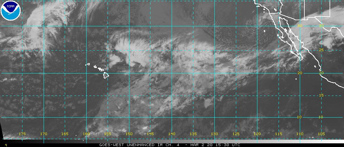
Tropical Cyclone activity in the eastern and central Pacific – Here’s the latest weather information coming out of the National Hurricane Center, covering the eastern north Pacific. You can find the latest tropical cyclone information for the central north Pacific (where Hawaii is located) by clicking on this link to the Central Pacific Hurricane Center. A satellite image, which shows the entire ocean area between Hawaii and the Mexican coast…can be found here. Here's a tropical cyclone tracking map for the eastern and central Pacific.
Aloha Paragraphs

Trade wind weather continues…Fernanda retired
The trade winds will continue, moderate strong…somewhat lighter during the upcoming weekend and beyond. Glancing at this weather map, we find a moderately strong 1024 millibar high pressure system to the north of the islands, with a 1026 millibar high pressure cell far to the northeast. These high pressure areas and their associated ridges will provide steady trade winds.
Our trade winds will remain active…the following numbers represent the strongest gusts (mph), along with directions Friday evening:
28 Port Allen, Kauai – NE
23 Honolulu, Oahu – NE
24 Molokai – NE
28 Kahoolawe – ESE
27 Kahului, Maui – NE
04 Lanai
30 Upolu Point, Big Island – NE
We can use the following links to see what’s going on in our area of the north central Pacific Ocean Friday night. Looking at this NOAA satellite picture we find scattered low level clouds in most directions, some of which are being carried through the islands. The clouds associated with former tropical cyclone Fernanda are showing up on the right hand side of this satellite picture too. We can use this looping satellite image to see those lower level clouds approaching from the east. We can also find what's left of old Fernanda spinning in a direction that will take it to the south of Hawaii. There's an upper level low pressure system to our north-northwest, spinning in a counterclockwise fashion. Checking out this looping radar image we see a few showers falling locally, some of which are being carried over the windward sides in places…on the trade wind flow.
Thursday evening after work I went to see a new film, which will be nice after a big week of weather work. This new film was called Cowboys and Aliens, starring Daniel Craig, Olivia Wilde, and Harrison Ford…among many others. This film looked rather interesting, and somewhat surprising to me, it was. Daniel Craig stars as a Wild West gunslinger who leads a fight for survival against a terror from beyond our world. I mean, how bad could a film be with such an unusual context? The critics are giving it a B- grade, with the viewers are upping that slightly to a B. I was in the mood, as I almost always am by the end of a long work week, to be entertained. As it turned out, this was a big film, long and full of action, which I enjoyed more than I thought I was going to. It was a bit far fetched at times, especially when it came to the monsters, but whatever. I feel comfortable giving it a good solid B grade, and more than that, I'm glad that I saw it! Here's the trailer for this film.
Sunset Commentary: The Hawaiian Islands continue to be in a well-established summer trade wind weather pattern Friday night. High pressure to the north and northeast of the islands is the driving force for our moderately strong trades. These will continue today, although as we move into the weekend, the computer models suggest they may lose their edge a little, coming down a notch as we move into the new week ahead.
As is very common while the trade wind flow is present, the most notable showers are brought our way during the night and early morning hours. The atmosphere over and around the islands remains quite dry and stable, which in turn will limit our showers somewhat. They will still be around, although will fall generally in the light category…with just a few exceptions here and there. We should see an increase in showers Sunday into early in the new week, as the northern fringe of dissipated tropical cyclone Fernanda, moves by to the south of the state…bringing the windward sides of the Big Island and Maui showers, and perhaps a few elsewhere too.
Speaking of Fernanda, she has now been retired by the Central Pacific Hurricane Center. Here’s a satellite image showing what's left of former Fernanda in relation to the Hawaiian Islands. Here’s the same picture with the looping feature on. This retired system will be able to bring the southern part of the island chain some moisture…starting early Sunday and lasting for a day or so. A rather humid tropical air mass, associated with old Fernanda will bring muggy weather to the islands for several days too.
Then, well to the east of former Fernanda, we have what has become tropical storm Greg…down from a category 1 hurricane just yesterday. It will remain far away from our islands…staying safely in the eastern Pacific. Here’s the latest NHC graphical track map for Greg. Here’s the latest NOAA satellite picture of Greg, moving away from the Mexican coast.
Here in Kula, Maui at near 5pm HST Friday evening, skies were partly cloudy, with an air temperature of 74.5F degrees. As noted above, our trade wind weather will continue, with generally fine conditions prevailing through Saturday. Recent tropical depression Fernanda is now fizzled out, with just a few thunderstorms flaring up on the north side of the diminishing circulation. So, there really isn't anything to worry about here in the islands. We may see some increased showers as the northern fringe of left over tropical moisture arrives, with Maui and the Big Island picking up the bulk of that…along the windward sides for the most part. It will feel more humid starting Sunday for a day or so too. ~~~ So, Fernanda is through with its mild threat for the Hawaiian Islands, although we may still get a feel of this tropical moisture, which began in the eastern Pacific. I'll have more to say about this Saturday morning, when I'll have your next new weather narrative ready for the reading. I hope you have a great Friday night until then! Aloha for now…Glenn.
Today was Statehood Day in Hawai'i, which is a holiday. I feel very fortunate that I live in the wonderful state of Hawai'i!
Bruddah IZ – Hawai'i Aloha
Country Comfort Waimanalo Blues
Keola and Kapono Beamer Honolulu City Lights
Olomana Ku'u Home O Kahulu'o