


Air Temperatures – The following maximum temperatures were recorded across the state of Hawaii Tuesday:
Lihue, Kauai – 85
Honolulu airport, Oahu – 88 (record for Tuesday – 89 in 1981)
Kaneohe, Oahu – 82
Molokai airport – 84
Kahului airport, Maui – 86
Kona airport 87
Hilo airport, Hawaii – 78
Air Temperatures ranged between these warmest and coolest spots near sea level – and on the highest mountain tops…as of 5pm Tuesday evening:
Barking Sands, Kauai – 85
Hilo, Hawaii – 79
Haleakala Crater – 57 (near 10,000 feet on Maui)
Mauna Kea Summit – 45 (over 13,500 feet on the Big Island)
Here are the 24-hour precipitation totals (inches) for each of the islands as of Tuesday evening:
0.15 Mount Waialeale, Kauai
0.12 Manoa Valley, Oahu
0.06 Molokai
0.00 Lanai
0.00 Kahoolawe
0.80 West Wailuaiki, Maui
0.93 Kawainui Stream, Big Island
Marine Winds – Here’s the latest (automatically updated) weather map showing a 1025 millibar high pressure system to the north-northeast of our islands. Our local trade winds will remain active through Thursday and beyond…locally strong and gusty.
Satellite and Radar Images: To view the cloud conditions we have here in Hawaii, please use the following satellite links, starting off with this Infrared Satellite Image of the islands to see all the clouds around during the day and night. This next image is one that gives close images of the islands only during the daytime hours, and is referred to as a Close-up visible image. Finally, here's a Looping IR satellite image, making viewable the clouds around the islands 24 hours a day. To help you keep track of where any showers may be around the islands, here’s the latest animated radar image.
Hawaii’s Mountains – Here’s a link to the live web cam on the summit of near 13,500 foot Mauna Kea on the Big Island of Hawaii. The tallest peak on the island of Maui is the Haleakala Crater, which is near 10,000 feet in elevation. These two web cams are available during the daylight hours here in the islands…and when there’s a big moon shining down during the night at times. Plus, during the nights you will be able to see stars, and the sunrise and sunset too…depending upon weather conditions.
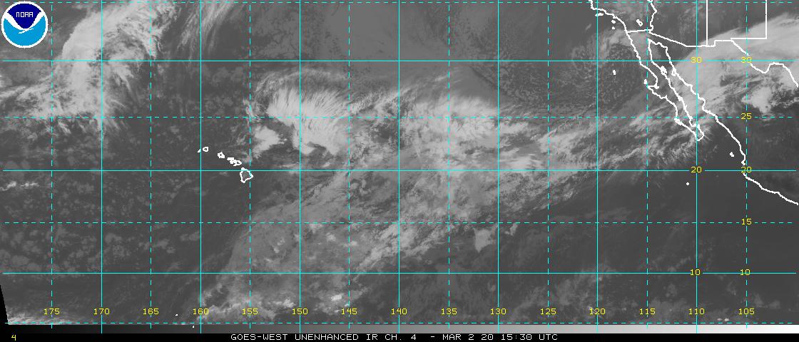
Tropical Cyclone activity in the eastern and central Pacific – Here’s the latest weather information coming out of the National Hurricane Center, covering the eastern north Pacific. You can find the latest tropical cyclone information for the central north Pacific (where Hawaii is located) by clicking on this link to the Central Pacific Hurricane Center. A satellite image, which shows the entire ocean area between Hawaii and the Mexican coast…can be found here. Here's a tropical cyclone tracking map for the eastern and central Pacific.
Aloha Paragraphs
Trade winds…locally strong and gusty
The trade winds will continue, moderate to locally strong and gusty. Glancing at this weather map, we find a moderately strong 1025 millibar high pressure system to the north-northeast of the islands. This high pressure area, and its associated ridge will provide steady trade winds…locally stronger and gusty. The small craft wind advisory continues in those windiest coasts and channels around Maui County and the Big Island.
Our trade winds will remain active…the following numbers represent the strongest gusts (mph), along with directions Tuesday evening:
32 Port Allen, Kauai – ENE
28 Kahuku, Oahu – NE
31 Molokai – NE
25 Kahoolawe – NE
32 Kahului – NE
22 Lanai – NE
28 South Point, Big Island – NE
We can use the following links to see what’s going on in our area of the north central Pacific Ocean Tuesday night. Looking at this NOAA satellite picture we find only scattered low level clouds being carried into our windward sides. At the same time we see high level clouds to the southwest, spreading over the islands in places. We can use this looping satellite image to those high cirrus clouds moving through the state at times…with more approaching from the southwest. These are being drawn over the state in association with a departing upper level low pressure system, far to the north of Kauai. Checking out this looping radar image we see just a few showers falling locally, some of which are being carried over the windward sides in places…on trade wind flow.
Sunset Commentary: Somewhat windier than normal, and drier than normal for the time being here in the islands. High pressure to our north will keep the locally strong and gusty trade winds blowing through the next several days. Yesterday we had wind gusts up into the middle 40 mph range, and today hit 39 mph on Molokai. This trend will continue through Thursday, with a slight reduction Friday, going into the weekend…and on into next week.
The overlying atmosphere is stable and relatively dry compared to normal. There doesn’t seem to be much change expected in this regard, at least through Thursday. Despite this rather dry reality, the windward sides continue to coax out a few showers, mostly during the cooler night hours. We might see a change, although not a big one, coming up Friday into the weekend. The surrounding air mass may become more shower prone for a few days then.
The big deal now, at least here in the Pacific Ocean, is the strengthening tropical storm Fernanda in the eastern Pacific. Further to the east we find newly formed tropical depression 07E…which will likely become the stronger of the two eventually. Fernanda is more of a concern for us though, as it's forecast to come into our central Pacific as a low level hurricane. Here’s the official NHC forecast track map. Here’s a satellite image showing both Hawaii and Fernanda to our east-southeast…and 07E further to the east towards Mexico. Given the latest information, Fernanda won’t be a problem for our islands however, as it dissipates to the southeast of the Big Island later this weekend. Nonetheless, this storm needs to be watched for any unexpected changes in strength or direction.
Here in Kihei, Maui at 530pm HST Tuesday evening, skies were mostly clear, with stiff trade wind breezes pushing the coconut palm trees from side to side. Actually, there are hardly any clouds around anywhere in the island chain. Some of the leftover high cirrus are mostly streaking across Kauai, although there are more of those looming down to the southwest, over the ocean. I'm just about to leave for my drive back upcountry to Kula, I can hardly wait to get home for my early evening walk. For dinner this week, which is the same as I had last week, is organic tortilla's, organic refried beans, organic colby cheese, avocado, fresh Maui salsa, and salad out of the garden. This time of year there are so many lettuce plants going off in our garden, it seems to make sense to eat tortillas. At any rate, I'll be back with you early Wednesday morning with your next new weather narrative from paradise. I hope you have a great Tuesday night until then! Aloha for now…Glenn.