


Air Temperatures – The following maximum temperatures were recorded across the state of Hawaii Monday:
Lihue, Kauai – 86 (record for Monday – 88 in 1981)
Honolulu airport, Oahu – 86 (record for Monday – 92 in 2005)
Kaneohe, Oahu – 82
Molokai airport – 84
Kahului airport, Maui – 85
Kona airport 85
Hilo airport, Hawaii – 84
Air Temperatures ranged between these warmest and coolest spots near sea level – and on the highest mountain tops…as of 5pm Monday evening:
Barking Sands, Kauai – 86
Kaneohe, Oahu – 79
Haleakala Crater – 59 (near 10,000 feet on Maui)
Mauna Kea Summit – 46 (over 13,500 feet on the Big Island)
Here are the 24-hour precipitation totals (inches) for each of the islands as of Monday evening:
0.17 Mount Waialeale, Kauai
0.12 Schofield South, Oahu
0.03 Molokai
0.00 Lanai
0.00 Kahoolawe
0.55 West Wailuaiki, Maui
0.65 Kawainui Stream, Big Island
Marine Winds – Here’s the latest (automatically updated) weather map showing a 1024 millibar high pressure system to the north-northeast of our islands. Our local trade winds will remain active through Tuesday and beyond, locally strong and gusty.
Satellite and Radar Images: To view the cloud conditions we have here in Hawaii, please use the following satellite links, starting off with this Infrared Satellite Image of the islands to see all the clouds around during the day and night. This next image is one that gives close images of the islands only during the daytime hours, and is referred to as a Close-up visible image. Finally, here's a Looping IR satellite image, making viewable the clouds around the islands 24 hours a day. To help you keep track of where any showers may be around the islands, here’s the latest animated radar image.
Hawaii’s Mountains – Here’s a link to the live web cam on the summit of near 13,500 foot Mauna Kea on the Big Island of Hawaii. The tallest peak on the island of Maui is the Haleakala Crater, which is near 10,000 feet in elevation. These two web cams are available during the daylight hours here in the islands…and when there’s a big moon shining down during the night at times. Plus, during the nights you will be able to see stars, and the sunrise and sunset too…depending upon weather conditions.
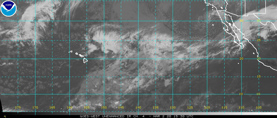
Tropical Cyclone activity in the eastern and central Pacific – Here’s the latest weather information coming out of the National Hurricane Center, covering the eastern north Pacific. You can find the latest tropical cyclone information for the central north Pacific (where Hawaii is located) by clicking on this link to the Central Pacific Hurricane Center. A satellite image, which shows the entire ocean area between Hawaii and the Mexican coast…can be found here. Here's a tropical cyclone tracking map for the eastern and central Pacific.
Aloha Paragraphs

Trade winds continue…locally strong and gusty
Photo Credit: Alexander Frings
The trade winds will continue, generally in the moderately strong realms through this new week….although stronger at times. Glancing at this weather map, we find a moderately strong 1024 millibar high pressure system to the north-northeast of the islands, moving west-southwest closer to the islands. This high pressure area, and its associated ridge will provide steady trade winds…locally stronger and gusty. The small craft wind advisory continues in those windiest coasts and channels around Maui County and the Big Island.
Our trade winds will remain active…the following numbers represent the strongest gusts (mph), along with directions Monday evening:
32 Port Allen, Kauai – NE
27 Honolulu, Oahu – ENE
29 Molokai – NE
28 Kahoolawe – NNE
33 Kahului – NE
16 Lanai – NE
32 South Point, Big Island – NE
We can use the following links to see what’s going on in our area of the north central Pacific Ocean Monday night. Looking at this NOAA satellite picture we find low level clouds coming into our windward sides, especially on the Big Island into Oahu at the time of this writing. At the same time we see high level clouds coming up over parts of the state from the southwest. We can use this looping satellite image to those high cirrus clouds moving through the state. These are being drawn over the state in association with an upper level low pressure system, not far to the northwest of Kauai. Checking out this looping radar image we see a few showers here and there, falling along the windward sides in places.
Sunset Commentary: The name of the game now will be the rather strong and gusty trade wind flow. These trade winds early this afternoon were gusting up to 42 mph at Kahoolawe, and to an impressive 44 mph at Kawaihae down on the Big Island. High pressure to our north this week will keep these blustery trade winds around, with little change for the time being.
As for rainfall, the overlying atmosphere is somewhat drier than normal, which will limit our incoming showers to some extent. Nonetheless, with the trade winds blowing this strongly, there will continue to be passing showers at times. The computer models are suggesting that we may see an increase in windward biased showers during the second half of this work week, although likely nothing too out of the ordinary.
Well to the east-southeast of the Hawaiian Islands, and still in the eastern Pacific, we have a new tropical cyclone spinning. It’s traveling more or less westward, heading towards our central Pacific. It’s expected to strengthen to a tropical storm, named Fernanda by Tuesday morning. It’s forecast to enter our central Pacific early Thursday morning. The current National Hurricane Center prediction keeps this system from attaining hurricane strength…and there are some signs showing that it could dissipate rather quickly within the next five days.
Here’s a satellite image showing this depression in relation to the Hawaiian Islands…which can be located about 1500+ miles to our east-southeast.
~~~ Here in Kihei, Maui this evening at around 530pm, skies were partly cloudy, with the trade winds blowing steadily. As noted above, nothing out of the ordinary is on tap for this week. The trade winds will continue to blow, with all of the other usual typical conditions holding steady. I'm still closely watching the eastern Pacific, as newly formed tropical depression (06E) remains active tonight. The computer models are showing it moving into our central Pacific early Thursday morning. Here's the latest National Hurricane Center's track map on this tropical depression, showing the area moving more or less westward. This what will be called tropical storm Fernanda, will be no threat for the Hawaiian Islands, but bears watching, which I will be doing. Here's a satellite image of this tropical depression. I hope you have a great Monday night, I'll have your next new weather narrative early Tuesday morning, along with more information about 06E as well. Aloha for now…Glenn.