


Air Temperatures – The following maximum temperatures were recorded across the state of Hawaii Saturday:
Lihue, Kauai – 83
Honolulu airport, Oahu – 86 (record for the date: 89 – 1990)
Kaneohe, Oahu – 80
Molokai airport – 77
Kahului airport, Maui – 76
Kona airport – 84
Hilo airport, Hawaii – 83
Air Temperatures ranged between these warmest and coolest spots near sea level – and on the highest mountain tops…as of 5pm Saturday evening:
Honolulu, Oahu – 82
Hilo, Hawaii – 76
Haleakala Crater – 46 (near 10,000 feet on Maui)
Mauna Kea summit – 37 (over 13,500 feet on the Big Island)
Precipitation Totals – The following numbers represent the largest precipitation totals Saturday evening:
1.97 Mount Waialeale, Kauai
0.74 Waiawa, Oahu
0.00 Molokai
0.00 Lanai
0.00 Kahoolawe
0.03 Kula, Maui
0.15 Pahala, Big Island
Marine Winds – Here’s the latest (automatically updated) weather map showing a 1038 millibar high pressure system far to the northeast of the Hawaiian Islands, along with a 1026 millibar high pressure cell to our northwest.. At the same time we find a trough of low pressure to our north and northwest. Our local trade winds will continue to be light…although stronger locally at times through Monday.
Satellite and Radar Images: To view the cloud conditions we have here in Hawaii, please use the following satellite links, starting off with this Infrared Satellite Image of the islands to see all the clouds around during the day and night. This next image is one that gives close images of the islands only during the daytime hours, and is referred to as a Close-up visible image. This next image shows a larger view of the Pacific…giving perspective to the wider ranging cloud patterns in the Pacific Ocean. Finally, here's a Looping IR satellite image, making viewable the clouds around the islands 24 hours a day. To help you keep track of where any showers may be around the islands, here’s the latest animated radar image.
Hawaii’s Mountains – Here’s a link to the live web cam on the summit of near 13,500 foot Mauna Kea on the Big Island of Hawaii. The tallest peak on the island of Maui is the Haleakala Crater, which is near 10,000 feet in elevation. These two web cams are available during the daylight hours here in the islands…and when there’s a big moon shining down during the night at times. Plus, during the nights you will be able to see stars, and the sunrise and sunset too…depending upon weather conditions.
Tropical Cyclone activity in the eastern and central Pacific – Here’s the latest weather information coming out of the National Hurricane Center, covering the eastern north Pacific. You can find the latest tropical cyclone information for the central north Pacific (where Hawaii is located) by clicking on this link to the Central Pacific Hurricane Center. Here’s a tracking map covering both the eastern and central Pacific Ocean. A satellite image, which shows the entire ocean area between Hawaii and the Mexican coast…can be found here. Of course, as we know, our hurricane season ended November 30th here in the central Pacific…and begins again June 1st.
Aloha Paragraphs
Light to moderately strong breezes,
with clouds leading to localized showers
especially during the afternoons…some
heavy, with possible thunderstorms.
Our winds will be light to moderately strong…then picking up again towards Wednesday onwards. Glancing at this weather map, we find a strong 1038 millibar high pressure system located far to the northeast of the Hawaiian Islands…along with a weaker high pressure cell to our northwest. An upper level trough of low pressure near the state will stick around into the new week. This will result in slightly lighter than normal winds through the first half of the week. As the trough moves away, our trade wind speeds will increase…likely by around Wednesday through the remainder of the week.
Our local winds will remain from the trade wind direction, or slightly to the south of east…the following numbers represent the strongest gusts, along with directions Saturday evening:
24 mph Port Allen, Kauai – NE
18 Kahuku, Oahu – SW
21 Molokai – NNE
25 Kahoolawe – ESE
24 Kahului, Maui – NE
06 Lanai Airport – NW
28 South Point, Big Island – NE
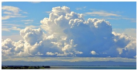
We can use the following links to see what’s going on in our area of the north central Pacific Ocean Saturday night. Looking at this NOAA satellite picture we see variable clouds over the ocean around the islands. There are a mix of lower cumulus clouds…along with some towering cumulus around the edges too…even a few cumulonimbus around and to the northwest of Kauai. We can use this looping satellite image to see a stream of high and middle level clouds moving by to our south and southeast, getting very near the Big Island now. At the same time we find an upper trough of low pressure to our northwest…where thunderstorms are pulsing. An area of cold air has shifted over the islands, sparking some vertical motion in our local cumulus clouds…with an increased chance of heavy showers during the next several days. Checking out this looping radar image shows some moderately heavy to heavy showers falling over the ocean near Kauai.
Friday evening I went to see a new film in Kahului, Maui. It was called Water for Elephants, starring Robert Pattinson and Reese Witherspoon…among others. This film is about a depression-era drama, with a veterinary med school dropout who joins the circus. The critics are giving this film a B- grade, while the viewers are upping the anty to an A- rating. As some of you know Robert Pattinson is a teenage heart throb, while Reese Witherspoon just got married in real life. I enjoyed the film for the most part, although there were some parts that I didn't enjoy too. I very much appreciate animal life in all its forms, and despite the fact that it was just a film, I didn't like seeing the elephant being hit with what's called a bull stick. I enjoyed the story though, and could give it slightly less than a B grade overall. Here's a trailer for those of you care to check it out.
Sunset Commentary: Here in Kula, Maui at around 515pm Saturday evening, skies were partly to mostly cloudy, with a air temperature of 64F degrees. I want to show this looping radar image again, just to point out the locally heavy showers falling over the ocean near Kauai. The air mass over and around the islands is quite unstable, especially on the Kauai end of the island chain. This is what's making it so shower prone. Today Maui started off quite clear, and it stayed that way generally down near the coasts, or at least clear to partly cloudy. It got cloudy over and around the mountains, and has been showering off and on for the last hour or two. It never ended up getting heavy, although I expect it will begin to turn heavier during the afternoons through Monday or Tuesday. It wouldn't surprise me to see thunderstorms either, along with a chance of snow atop the tall mountains on the Big Island. The threat of heavy showers will end by the middle of the upcoming new work week, likely by mid-week…as the trade winds pick up through the rest of the week.
~~~ I'll be driving over to Haiku this evening, as there some dancing happening there. It won't be a long period of dancing, actually only about a couple of hours. It don't mind though, as I'll likely be home by 1130pm or so, which is better than 2am like last Saturday night! At any rate, I'll be back here Sunday morning with your next new weather narrative. I hope you have a great Saturday night until then! Aloha for now…Glenn.
Interesting: Landfill gas recovery is becoming a familiar fixture in the alternative energy scene, and now New York City has added a new dimension to the idea of extracting valuable resources from seemingly useless parcels of land. The city plans to build utility-scale solar installations on its old landfills, to the tune of about 50 megawatts. Admittedly, that's a drop in the bucket in terms of the city’s overall electricity use. However, the solar program is focused on achieving a clean air goal, which has its own public health value.
The new solar installations will reduce emissions from petroleum-fueled generators, which the city currently has to use on hot summer days to meet peak demand. That raises an interesting point for a company with decommissioned landfills or other derelict property on its hands: aside from producing clean (and potentially cheaper) energy, what additional value could a solar installation have?
Brownfields, Green Jobs and Community Relations Aside from helping to improve local air quality, the first thing that comes to mind is job creation. New York City's plan is actually a local version of a federal program called RE-Powering America's Land, which seeks to develop brownfields and Superfund sites for renewable energy. Many of these sites are located in or near populated areas, sucking up real estate.
The program has a strong emphasis on putting that land back into economic circulation, by creating green jobs for local residents. In contrast to company-sponsored green volunteer projects, solar energy installations enable companies to create green job opportunities for local installers, electricians and other skilled trades. That's a powerful community relations tool in today’s tough economy.
Communities and Nature Conservation In urban areas, a brownfield-sited solar installation can turn a former eyesore into a source of local pride. It could also help communities preserve natural open space from development. The Nature Conservancy has pointed out that there is ample room in the U.S. for wind turbines on land that has already been developed and is inhospitable to endangered and threatened species.
In other words, less natural habitat would need to be disturbed for renewable energy, if we focus attention on land that has already been disturbed. Though there isn't necessarily going to be a direct trade-off, the availability of brownfields could factor into a local planning board’s decisions, and it could put a company in the position of helping to preserve open space by offering its property as a site for renewable energy.
Interesting2: China, the world's biggest emitter of greenhouse gases, could peak in emissions by 2030 or earlier, says a study from U.S. researchers who foresee Chinese demand for appliances, buildings and much industry reaching "saturation" around then. The study by energy and emissions experts at the Lawrence Berkeley National Laboratory in California adds to a growing body of studies that say China could reach its maximum output of carbon dioxide (CO2) within two decades.
That matters for more than China. Its emissions path will be crucial to determining whether the world can restrict total greenhouse gas emissions to levels less likely to trigger dangerous climate change, such as more intense droughts, floods and storms that threaten crops and economic growth. "Once nearly every household owns a refrigerator, a washing machine, air conditioners and other appliances, and once housing area per-capita has stabilized, per-household electricity growth will slow," said co-author Mark Levine in a statement.
China, with 1.34 billion people, already emits a quarter of the world's CO2. This is more than the United States, historically the world's top emitter of the main greenhouse gas from human activity fuelling climate change. It overtook the United States several years ago. India is the third top carbon polluter.
How soon China's emissions peak and at what levels will depend on how vigorously the government pursues cleaner growth policies, especially moving energy from coal to nuclear, hydro-power and renewable energy, said the researchers. China generates most of its electricity using coal, the dirtiest of the fossil fuels, but is already investing heavily in cleaner energy.
The researchers say China can achieve a peak earlier and lower than other studies have suggested, in part because by about 2030, the country's demand for many emissions-intensive goods and industries will reach a plateau, a factor they say those studies overlook. Such goods include steel and cement.
Interesting3: The humpback whale is a species of baleen whale. Adults range in length from 39—52 feet and weigh approximately 79,000 pounds. Like other large whales, the humpback was and is a target for the whaling industry. Due to over-hunting, its population fell by an estimated 90% before a whaling moratorium was introduced in 1966. Stocks have since partially recovered.
There are at least 80,000 humpback whales worldwide. Scientists have recently observed a super-aggregation of more than 300 humpback whales gorging on the largest swarm of Antarctic krill seen in more than 20 years in bays along the Western Antarctic Peninsula.
The sightings, made in waters still largely ice-free deep into austral autumn, suggest the previously little-studied bays are important late-season foraging grounds for the endangered whales. But they also highlight how rapid climate change is affecting the region.
Krill is the common name given to the small invertebrates that are found in all oceans of the world. The common name krill comes from the Norwegian word krill meaning young fry of fish. Krill are considered an important near bottom of the food chain connection because they feed on phytoplankton and to a lesser extent zooplankton, converting these into a form suitable for many larger animals for whom krill makes up the largest part of their diet.
In the Southern Ocean, one species, the Antarctic krill, Euphausia superba, makes up an estimated biomass of over 500,000,000 tons, roughly twice that of all humans. Of this, over half is eaten by whales, seals, penguins, squid and fish each year.
Advancing winter sea ice used to cover much of the Antarctica peninsula’s bays and fjords by May, protecting krill and forcing humpback whales to migrate elsewhere to find food, but rapid climate change in the area over the last 50 years has significantly reduced the extent, and delayed the annual arrival, of the ice cover.
"The lack of sea ice is good news for the whales in the short term, providing them with all-you-can-eat feasts as the krill migrate vertically toward the bay’s surface each night. But it is bad news in the long term for both species, and for everything else in the Southern Ocean that depends on krill," says Ari S. Friedlaender, co-principal investigator on the project and research scientist at Duke.
Around the Western Antarctic Peninsula, krill migrate in austral autumn from open ocean waters to phytoplankton-rich bays and fjords, where juveniles feed and the population overwinters under the protective cover of ice. There is a correlation between the amount of sea ice and the amount of krill that survive the long, harsh Antarctic winter.
"If there are more areas with large aggregations of krill hanging out in waters where sea ice has diminished, you could see a big decrease in the standing krill stock, especially if we have a few years of back-to-back bad ice and the krill can’t replenish themselves," Friedlaender says.
Scientists already have documented drops in krill abundance over the last 50 years related to reduced sea ice cover. Seals and penguins have a relatively small foraging range, and some can’t eat any prey other than krill or hunt without the presence of sea ice. Whales can migrate longer distances and might be able to find food elsewhere, but may be affected in other ways.
"We’re starting to hear songs being produced by whales in the Antarctic — sexual advertisements typically heard only in humpback breeding grounds that are located thousands of miles away from these bays," Friedlaender says. Humpback whales typically reproduce once every three years, "so if a female doesn’t have to go to the breeding grounds every year — if she has access to food here and isn’t being forced out by sea cover — why should she leave?" Nowacek says.
The presence of more females, coupled with access to a nightly krill feast, entices more males to stick around too. "So this may affect the timing and location of humpback breeding and other important life cycle events." What is happening is a change in the existing ecosystem. What it will become is yet to be determined.
Interesting4: The first analysis of the healthful antioxidant content of blueberries that grow wild in Mexico, Central and South America concludes that some of these fruits have even more healthful antioxidants than the blueberries — already renowned as "super fruits" — sold throughout the United States. These extreme super fruits could provide even more protection against heart disease, cancer and other conditions, the report suggests.
It appears in ACS' Journal of Agricultural and Food Chemistry. Edward Kennelly and colleagues note that although there are over 600 species of blueberries and blueberry-like fruits growing in Mexico, Central and South America (the so-called "neo-tropics"), very little research has been done on them. U.S.-grown blueberries are already famous for their antioxidants, which help the body get rid of harmful free radicals.
So, the researchers decided to find out how neo-tropical blueberries stacked up against a grocery-store variety. They found that two types of neo-tropical blueberries were extreme super fruits — they had significantly more antioxidants than a type of blueberry commonly sold in U.S. supermarkets stores. The researchers say that these neo-tropical blueberries "have the potential to be even more highly promising edible fruits."