


Air Temperatures – The following maximum temperatures were recorded across the state of Hawaii Tuesday afternoon:
Lihue, Kauai – 81
Honolulu airport, Oahu – 82
Kaneohe, Oahu – 77
Molokai airport – 78
Kahului airport, Maui – 80
Kona airport – 83
Hilo airport, Hawaii – 79
Air Temperatures ranged between these warmest and coolest spots near sea level – and on the highest mountain tops…as of 5pm Tuesday evening:
Barking Sands, Kauai – 83F
Kaneohe, Oahu – 76
Haleakala Crater – missing (near 10,000 feet on Maui)
Mauna Kea summit – 39 (under 14,000 feet on the Big Island)
Precipitation Totals – The following numbers represent the largest precipitation totals late Tuesday evening:
1.10 Kilohana, Kauai
1.26 Waiawa, Oahu
0.14 Molokai
0.00 Lanai
0.01 Kahoolawe
1.56 Puu Kukui, Maui
0.97 Kawainui Stream, Big Island
Marine Winds – Here’s the latest (automatically updated) weather map showing a strong 1035 millibar high pressure system to the north of Hawaii. Our trade winds will be locally strong and gusty through Thursday.
Satellite and Radar Images: To view the cloud conditions we have here in Hawaii, please use the following satellite links, starting off with this Infrared Satellite Image of the islands to see all the clouds around during the day and night. This next image is one that gives close images of the islands only during the daytime hours, and is referred to as a Close-up visible image. This next image shows a larger view of the Pacific…giving perspective to the wider ranging cloud patterns in the Pacific Ocean. Finally, here's a Looping IR satellite image, making viewable the clouds around the islands 24 hours a day. To help you keep track of where any showers may be around the islands, here’s the latest animated radar image.
Hawaii’s Mountains – Here’s a link to the live web cam on the summit of near 14,000 foot Mauna Kea on the Big Island of Hawaii. The tallest peak on the island of Maui is the Haleakala Crater, which is near 10,000 feet in elevation. These two web cams are available during the daylight hours here in the islands…and when there’s a big moon rising just after sunset for an hour or two! Plus, during the nights and early mornings you will be able to see stars, and the sunrise too…depending upon weather conditions.
Tropical Cyclone activity in the eastern and central Pacific – Here’s the latest weather information coming out of the National Hurricane Center, covering the eastern north Pacific. You can find the latest tropical cyclone information for the central north Pacific (where Hawaii is located) by clicking on this link to the Central Pacific Hurricane Center. Here’s a tracking map covering both the eastern and central Pacific Ocean. A satellite image, which shows the entire ocean area between Hawaii and the Mexican coast…can be found here. Of course, as we know, our hurricane season ended November 30th here in the central Pacific…and begins again June 1st.
Aloha Paragraphs
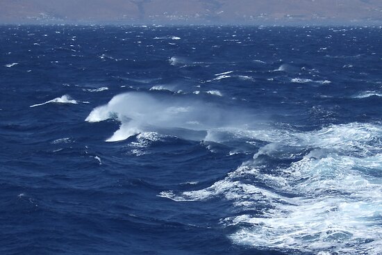
Rough and choppy seas…blustery trade winds
The trade winds will remain blustery through the next several days, although may finally ease up in strength some by the weekend into early next week. According to this weather map, we find a strong 1035 millibar high pressure system to the north of the islands Tuesday night. The outlook shows the trade winds strengthening a bit more through Thursday into Friday…calming down a touch as we move into the weekend and beyond. We still have our small craft wind advisory flags up over all the coastal and channel waters statewide. A wind advisory has recently gone up over the the entire state…which will remain active into Thursday.
Trade winds will be strong and gusty…the following numbers represent the strongest gusts, along with directions late Tuesday evening:
38 mph Port Allen, Kauai – ENE
36 Honolulu, Oahu – NE
35 Molokai – NE
43 Kahoolawe – ESE
39 Kapalua, Maui – ENE
21 Lanai Airport – NE
51 South Point, Big Island – NNE
We can use the following links to see what’s going on in our area of the north central Pacific Ocean Tuesday night. This large University of Washington satellite image shows high cirrus clouds to the west of the Hawaiian Islands…with streaks moving over the islands at times. This stuff may become thicker Wednesday. Looking at this NOAA satellite picture we see patches of lower level clouds around the state…particularly along the windward sides of the islands. We can use this looping satellite image to see lower level clouds moving in our direction from the east. At the same time we see more high cirrus clouds approaching from the west. Checking out this looping radar image shows quite a few showers moving across the windward sides of the islands.
The ocean is whipped up into white caps, while our coconut palm trees are leaning over under the influence of our strong trade winds. There were wind gusts topping 40 mph today on most of the islands, with even 50+ mph gusts down at South Point on the Big Island. I wouldn't call this rare by any means, although it is somewhat unusual. Spring is often our most windy season, and our local weather is sticking to the climatological norm pretty closely now. I think we'll find more gusts well up into the 40's and even reaching a few miles per hour over the 50 mph mark Wednesday and Thursday. The winds at night are usually the lightest during a 24 hour period, increasing to their maximum during the later morning through early evening period. During my lunch break today here in Kihei, Maui, I drove by the beach and saw millions of white caps chalking-up the ocean surface. Interestingly enough, studies have been done showing that windy weather is the most irritating for human beings, do you agree? ~~~ Here in Kihei, around 530pm, before I take the drive back upcountry to Kula, it's breezy, but nothing too out of the ordinary. There are those streaks of high cirrus clouds, which could make for a nice sunset this evening. There looks to be some sort of pretty thick drizzle cloud hugging the windward sides this evening too. If you liked the weather today, you will like it again on Wednesday, and besides a possible increase in windward showers on Thursday, it shouldn't change much then either. I'll meet you back here early Wednesday morning, at least here in the Hawaiian time zone, with your next new weather narrative from our windy reality here in the tropics. I hope you have a great Tuesday night until then! Aloha for now…Glenn.
Susan Says:
Hi Glenn…regarding the effects of windy weather…in general I love breezy, windy days…the only winds I personally dislike are the destructive ones…I lived through tornadoes and violent thunderstorms in Texas and Kansas–very scary. Trades, on the other hand, even strong ones, are usually a great blessing here in Hawaii, so soothing to listen to, keeping the vog at bay, and making the weather cooler and drier than Kona winds, although things do get dusty. Then again, when associated with wildfires, here, as elsewhere, any windy weather can be a threat.~~~Hi Susan, a very well rounded note, thanks for putting it in perspective…from your many experiences of wind. I don’t dislike wind at all, and accept it as I accept all the many variations that our wonderful skies share with us. I think perhaps my favorites may be thunderstorms, fog, and cool weather in general. I’ve always enjoyed dressing for the weather, which is at least part of the reason that I live up here in Kula, where its not just t-shirts and shorts. Thanks for responding to my question, I appreciate your point of view. Aloha, Glenn
Blair Thorndike Says:
I have a friend who is fighting the big brush/forest fire on the Big Island. He surmised that the haze we saw Sunday/Monday was likely smoke from the large fire. Just a guess….Hi Blair, that sounds pretty reasonable to me, thanks for providing some clue about all that recent haze. Today it is dusty, lots of dust being kicked up by the strong and gusty trade winds. Aloha, Glenn