


November 20-21, 2010
Air Temperatures – The following maximum temperatures were recorded across the state of Hawaii Saturday afternoon:
Lihue airport, Kauai – 79
Honolulu airport, Oahu – 84
Kaneohe, Oahu – 82
Molokai airport – 81
Kahului airport, Maui – 83
Kona airport – 82
Hilo airport, Hawaii – 81
Air Temperatures ranged between these warmest and coolest spots near sea level – and on the highest mountain tops…as of 4pm Saturday afternoon:
Honolulu, Oahu – 83F
Hana, Maui – 73
Haleakala Crater – 46 (near 10,000 feet on Maui)
Mauna Kea summit – 39 (near 14,000 feet on the Big Island)
Precipitation Totals – The following numbers represent the largest precipitation totals (inches) during the last 24 hours on each of the major islands, as of Saturday afternoon:
0.12 Poipu, Kauai
0.08 Wilson Tunnel, Oahu
0.10 Molokai
0.00 Lanai
1.38 Kahoolawe
0.38 Kaupo Gap, Maui
1.70 Hilo airport, Big Island
Marine Winds – Here’s the latest (automatically updated) weather map showing high pressure systems far north and east of the islands. Our local winds will remain generally light though, as there are a couple of troughs of low pressure blocking their arrival at the moment…trades returning later Monday.
Satellite and Radar Images: To view the cloud conditions we have here in Hawaii, please use the following satellite links, starting off with this Infrared Satellite Image of the islands to see all the clouds around during the day and night. This next image is one that gives close images of the islands only during the daytime hours, and is referred to as a Close-up visible image. This next image shows a larger view of the Pacific…giving perspective to the wider ranging cloud patterns in the Pacific Ocean. Finally, here's a Looping IR satellite image, making viewable the clouds around the islands 24 hours a day. To help you keep track of where any showers may be around the islands, here’s the latest animated radar image.
Hawaii’s Mountains – Here’s a link to the live webcam on the summit of near 14,000 foot Mauna Kea on the Big Island of Hawaii. The tallest peak on the island of Maui is the Haleakala Crater, which is near 10,000 feet in elevation. These two webcams are available during the daylight hours here in the islands…and when there’s a big moon rising just after sunset for an hour or two! Plus, during the nights and early mornings you will be able to see stars, and the sunrise too…depending upon weather conditions.
Tropical Cyclone activity in the eastern and central Pacific – Here’s the latest weather information coming out of the National Hurricane Center, covering the eastern north Pacific. You can find the latest tropical cyclone information for the central north Pacific (where Hawaii is located) by clicking on this link to the Central Pacific Hurricane Center. Here’s a tracking map covering both the eastern and central Pacific Ocean. A satellite image, which shows the entire ocean area between Hawaii and the Mexican coast…can be found here. Of course, as we know, our hurricane season won't end until November 31st here in the central Pacific.
Aloha Paragraphs
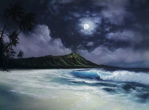
November full moon tonight
Winds will remain on the light side through Sunday…with light easterly trade winds returning by the beginning of the new work week. The computer models continue to suggest that the trade winds will return later Monday, becoming light to moderately strong through mid-week. Later in the week, the trade winds will strengthen further, becoming moderately strong or more. This will likely lead to small craft wind advisories going up over those windiest areas around Maui County and the Big Island…by Thanksgiving for several days.
Winds around the state remain generally light…with the following numbers representing the strongest gusts early Saturday evening:
23 mph Port Allen, Kauai
17 Kahuku, Oahu
00 Molokai
20 Kahoolawe
21 Lipoa, Maui
00 Lanai Airport
09 Honokaa, Big Island
The upper trough of low pressure that brought localized showers recently, some of which which were locally heavy…is moving away towards the east now. Skies are ranging between clear and cloudy, depending upon which part of the state one lives in. This IR satellite image shows high clouds moving in towards Kauai, and clouds further to the east and northeast of the Big Island too. If we look at an even larger view, using this next satellite picture, we can see that there are lots of high and middle level clouds over the ocean surrounding the islands. Meanwhile, this looping radar image shows that there are a few showers over the ocean, being carried along in what looks like a light easterly trade wind flow near the Big Island end of the chain already.
It's Saturday evening as I begin writing this last section of today's narrative update. The weather today was quite nice, although the daytime heating of the islands, and the onshore flowing sea breezes…carried lots of moisture up the slopes of the mountains. There were a few showers, but the heavier rains we saw over the last day or two, have faded away now. The beaches remained sunny, or at least partly sunny in most areas, with hardly any showers being reported. Sunday may see the trade winds returning a little earlier than the computer forecast models are suggesting, although certainly by Monday. Our weather in general will remain quite pleasant through most of the next week. We may however see a substantial increase in windward biased showers as the trade winds increase Tuesday into Wednesday. Thanksgiving, at least at this point, looks like it will be a good day from a weather perspective.
~~~ Here in Kula, Maui, at around 525pm, the air temperature was 65.7F degrees, under partly cloudy skies. This afternoon we had a short shower, although the drops were rather large, and plopped down on my weather deck pretty loudly. Since tonight is the November full moon, I'm strongly, or at least moderately…considering driving back down to Paia for some dancing. The music starts so late though, like around 1030, that I could have a hard time staying awake until 10 or so, when I'd drive down that way. I love dancing, and it is full moon after all, so I might make my way out. Whether or not I go, I'll be back here Sunday morning with your next new weather narrative from paradise. I hope you enjoy the full moon tonight, from wherever you happen to be gazing from. Aloha for now…Glenn.
Interesting: Comets are temporary night flashes across the sky. They are rarer than meteors and are further away. The EPOXI mission's recent encounter with comet Hartley 2 provided the first images clear enough for scientists to link jets of dust and gas with specific surface features.
The EPOXI mission spacecraft revealed a cometary snow storm created by carbon dioxide jets spewing out tons of golf-ball to basketball-sized fluffy ice particles from the peanut-shaped comet's rocky ends. At the same time, a different process was causing water vapor to escape from the comet's smooth mid-section.
This information sheds new light on the nature of comets and even planets. A comet is an icy small Solar System body that, when close enough to the Sun, displays a visible coma (a thin, fuzzy, temporary atmosphere) and sometimes also a tail. These phenomena are both due to the effects of solar radiation and the solar wind upon the nucleus of the comet.
Comet nuclei are themselves loose collections of ice, dust, and small rocky particles, ranging from a few hundred meters to tens of kilometers across. Scientists compared the new observed data to data from a comet the spacecraft previously visited that was somewhat different from Hartley 2.
In 2005, the spacecraft successfully released an impactor into the path of comet Tempel 1, while observing it during a flyby. The mission yielded results suggesting that the majority of a comet's water ice is below the surface, and that these reservoirs feed the jets of vaporized water that form the coma of Tempel 1.
"This is the first time we've ever seen individual chunks of ice in the cloud around a comet or jets definitively powered by carbon dioxide gas," said Michael A'Hearn, principal investigator for the spacecraft at the University of Maryland. "We looked for, but didn't see, such ice particles around comet Tempel 1."
The new findings show Hartley 2 acts differently than Tempel 1 or the three other comets with nuclei imaged by spacecraft. Carbon dioxide appears to be a key to understanding Hartley 2 and explains why the smooth and rough areas scientists saw respond differently to solar heating, and have different mechanisms by which water escapes from the comet's interior.
"When we first saw all the specks surrounding the nucleus, our mouths dropped," said Pete Schultz, EPOXI mission co-investigator at Brown University. "Stereo images reveal there are snowballs in front and behind the nucleus, making it look like a scene in one of those crystal snow globes."
Data show the smooth area of comet Hartley 2 looks and behaves like most of the surface of comet Tempel 1, with water evaporating below the surface and percolating out through the dust. However, the rough areas of Hartley 2, with carbon dioxide jets spraying out ice particles, are very different.
"The carbon dioxide jets blast out water ice from specific locations in the rough areas resulting in a cloud of ice and snow," said Jessica Sunshine, EPOXI deputy principal investigator at the University of Maryland.
"Underneath the smooth middle area, water ice turns into water vapor that flows through the porous material, with the result that close to the comet in this area we see a lot of water vapor." As might be expected every comet will be different though some similarities will occur.
Interesting2: You might think that politicians have enough on their plates trying to fix the economy, fighting wars in Iraq and Afghanistan, dealing with humanitarian crises in Haiti and Pakistan, and other matters of national import. But money talks, especially in politics, and a tiny bug is causing a big ruckus on Capitol Hill.
Today, Members of Congress, representatives from federal agencies, academic bed bug experts, the National Pest Management Association (NPMA), other industries and victims of bed bug infestations will gather at the Capitol Visitor Center in Washington, D.C. to participate in the "Don't Let Bed Bugs Bite" Congressional Forum organized by Representative G.K. Butterfield (D-NC).
The event, sponsored by the National Pest Management Association (NPMA), "will offer insights from the professional pest control industry about the extent of the bed bug problem, what the industry is doing to combat it and what the federal government can do to assist Americans whose lives are impacted by this pest."
How serious is the bed bug problem? The situation is dire, according to Missy Henriksen, vice president of public affairs for the NPMA: "Bed bugs are no longer a pest of the past or characters in a nursery rhyme, rather they are a real and serious problem. They have invaded not only residences, but public places as well. While our industry is committed to effectively eliminating the bed bug problem, federal intervention is also necessary. This Forum is a crucial first step."
Interesting3: When one imagines a squid, the image that comes to mind is of a giant monster (i.e, Kraken of mythic fame) grappling with boats and whales. Squid are marine cephalopods of the order Teuthida, which comprises around 300 species. Like all other cephalopods, squid have a distinct head, bilateral symmetry, a mantle, and arms.
Squid, like cuttlefish, have eight arms arranged in pairs and two, usually longer, tentacles. Squid are strong swimmers and certain species can 'fly' for short distances out of the water. Some are giant and some are tenaciously small.
An expedition to the seamounts of the southern Indian Ocean has proven that the region is a biodiverse hotspot for squids. To date, the expedition has identified 70 species of squid comprising 20% of the world's known squid species. But that's not all: they have also uncovered new species.
The majority of squids are no more than 24 inches long, although the giant squid may reach over forty feet in length. In 1978, sharp, curved claws on the suction cups of squid tentacles cut up the rubber coating on the hull of the USS Stein. The size suggested the largest squid known at the time.
In 2003, a large specimen of an abundant species, Mesonychoteuthis hamiltoni (the Colossal Squid), was discovered. This species may grow to 46 feet in length, making it the largest invertebrate. Squid have the largest eyes in the animal kingdom. Giant squid are featured in literature and folklore with a frightening connotation.
The Kraken is a legendary tentacled monster possibly based on the sightings of real giant squid. They are, in many ways, the epitome of what an alien creature should look like. At just over 2 feet long (27 inches), a species of squid found by the new Indian seamount expedition proves to be a brand new member of the chiroteuthid family.
Squids from this family, which number around a dozen known species, employ bioluminescent organs to attract unwary prey. Undertaken last year, the International Union for the Conservation of Nature (IUCN) expedition spent six weeks searching in the Indian Ocean.
Now, researchers are busy sorting out the 7,000 samples. There are many other isolated seamounts in the oceans of the world. Each one could help represent its own unique set of squids and other marine creatures.
Interesting4: The Chevrolet Volt plug-in electric car, the centerpiece of a revitalized General Motors Co, was named 2011 Green Car of the Year on Thursday. The highly anticipated Volt received the industry's top environmental honor the same day GM shares began trading — the biggest U.S. IPO ever.
The Volt edged out the Nissan Leaf and three other gas-sipping cars for the prize, which is awarded by Green Car Journal. "With the Volt we are making a bold pronouncement," said Joel Ewanick, GM's marketing chief, who accepted the award for the company.
"We need to be more aware of CO2 and fuel efficiency and it's a great start, but we're many, many years away from making that leap to where we need to be." Winning Green Car of the Year is yet another feather in the cap of the recovering 102-year-old automaker, which went from near-death in 2008 to a 2009 government bailout and bankruptcy to 2010 unlikely Wall Street flotation favorite.
General Motors' Volt, which its makers have touted as the symbol of a leaner and greener U.S. auto industry, is designed to run on electric power for about 40 miles, at which point it relies on a gasoline engine to charge the battery. The Nissan Motor Co Ltd Leaf is a plug-in that runs fully on electric power.
The Leaf will, on full charge, run for 100 miles or so, depending on road and weather conditions. Other finalists for the award included Ford Motor Co's new Fiesta, which can achieve 40 miles per gallon in highway driving. It was the only finalist not to use electric drive. Two hybrids, the Hyundai Motor Co Sonata Hybrid and Ford's Lincoln MKZ Hybrid, were also in the running.
Myrtle Says:
Hi Glenn — That November full moon is rising already. If you get up early tomorrow you can watch it set in the WNW around 5:30 a.m. –myrtle~~~Hi Myrtle, how nice to hear from you again, thanks for the tip on when it sinks into the Pacific to our west early Sunday morning! Aloha, Glenn
Willy Bennett Says:
What do bed bugs have to do with coral reefs?~~~Willy, no connection at all, at least that I can see. Sorry, that interesting story is now corrected. Aloha, Glenn
jeff mcconnel Says:
still trying to figure out the coral reef/bed bug problem connection….is it crabs?~~~Jeff, that is a good connection! I fixed that article just now, sorry for the under water dive there. Aloha, Glenn