


September 22-23, 2010
Air Temperatures – The following maximum temperatures were recorded across the state of Hawaii Wednesday afternoon:
Lihue airport, Kauai – 85
Honolulu airport, Oahu – 83
Kaneohe MCAS, Oahu – 81
Molokai airport – 85
Kahului airport, Maui – 89
Ke-ahole airport (Kona) – 85
Hilo airport, Hawaii – 81
Air Temperatures ranged between these warmest and coolest spots near sea level – and on the highest mountain tops…as of 5pm Wednesday evening:
Barking Sands, Kauai – 85
Hilo, Hawaii – 78
Haleakala Crater – 54 (near 10,000 feet on Maui)
Mauna Kea summit – 43 (near 14,000 feet on the Big Island)
Precipitation Totals – The following numbers represent the largest precipitation totals (inches) during the last 24 hours on each of the major islands, as of Wednesday afternoon:
0.47 Mount Waialeale, Kauai
3.08 Oahu Forest NWR, Oahu
0.04 Molokai
0.00 Lanai
0.01 Kahoolawe
0.42 West Wailuaiki, Maui
0.47 Kawainui Stream, Big Island
Marine Winds – Here’s the latest (automatically updated) weather map showing high pressure systems stretched out from the northeast through northwest of our islands. Our local trade winds will remain light to moderately strong through Thursday…locally stronger and gusty.
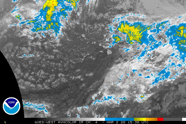
Satellite and Radar Images: To view the cloud conditions we have here in Hawaii, please use the following satellite links, starting off with this Infrared Satellite Image of the islands to see all the clouds around during the day and night. This next image is one that gives close images of the islands only during the daytime hours, and is referred to as a Close-up visible image. This next image shows a larger view of the Pacific…giving perspective to the wider ranging cloud patterns in the Pacific Ocean. Finally, here’s a Looping IR satellite image, making viewable the clouds around the islands 24 hours a day. To help you keep track of where any showers may be around the islands, here’s the latest animated radar image.
Hawaii’s Mountains – Here’s a link to the live webcam on the summit of near 14,000 foot Mauna Kea on the Big Island of Hawaii. The tallest peak on the island of Maui is the Haleakala Crater, which is near 10,000 feet in elevation. These two webcams are available during the daylight hours here in the islands…and when there’s a big moon rising just after sunset for an hour or two! Plus, during the nights and early mornings you will be able to see stars, and the sunrise too…depending upon weather conditions.
Tropical Cyclone activity in the eastern and central Pacific – Here’s the latest weather information coming out of the National Hurricane Center, covering the eastern north Pacific. You can find the latest tropical cyclone information for the central north Pacific (where Hawaii is located) by clicking on this link to the Central Pacific Hurricane Center. Here’s a tracking map covering both the eastern and central Pacific Ocean. A satellite image, which shows the entire ocean area between Hawaii and the Mexican coast…can be found here. Of course, as we know, our hurricane season won’t end until November 31st here in the central Pacific.
Aloha Paragraphs
Hawaiian artwork…Waikiki before humans arrived
Now through the rest of this work week…will be filled with light to moderately strong trade winds. The computer models continue to suggest that as we move into the upcoming weekend, especially by Sunday into next Monday…that our trade wind speeds will falter. This would happen as a deep low pressure in the Gulf of Alaska, and its associated cold front to our northwest, pushes our trade wind producing ridge of high pressure closer to our islands. This weather map shows high pressure systems strung out to the northwest through north and northeast of our islands Wednesday.
As our trade winds give way to lighter winds this weekend, we’ll shift into a convective weather pattern…lasting through the first part of next week. As this happens, we will shift into a different weather pattern…with daytime sea breezes, along with rather hot and muggy conditions at sea level locations. Typically, under this type of weather regime, we find clear to partly cloudy mornings, with slightly cooler than normal temperatures too. As the heating occurs during the day, clouds will form over and around the mountains…leading to localized upcountry showers.
Meanwhile, glancing south of the islands, using this satellite picture, we see those typical areas of thunderstorms to the southwest, south and southeast. The area of disturbed weather, which has been pulsing to the south remains active. As this satellite image shows, the area circled in orange has a 20% chance of spinning up into a tropical depression. As this picture points out, there is less spin to this area now however…which is a good thing! Here’s what the computer models are showing of its movements, if it were to develop further.
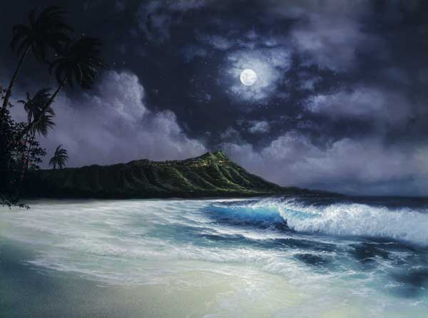
It’s Wednesday evening as I begin writing this last section of today’s narrative update. As pointed out above, this was the transition day between summer 2010, and autumn 2010. We continue to see an active tropical disturbance to the south of the state, and then up above…our September full moon happens tonight too. Here in Kihei, Maui, before I take the drive back upcountry to Kula, it’s clear to partly cloudy, and still breezy too. ~~~ Happy autumn to all of you, as we’ve made it through another summer without any damaging tropical storms. Isn’t that a cool picture above, which I put there to celebrate the full moon tonight! ~~~ I’ll be back early Thursday morning with your next new weather narrative, I hope you have a great Wednesday night until then! Aloha for now…Glenn.
Interesting: Snow melt in the Colorado River basin is occurring earlier, reducing runoff and the amount of crucial water available downstream. A new study by NASA/UCLA shows this is due to increased dust caused by human activities in the typically arid American southwest region during the past 150 years. The Colorado River is a river in the Southwestern United States and northwestern Mexico which is approximately 1,450 miles long.
The natural course of the river flows from the Continental Divide at La Poudre Pass in Colorado, into the Gulf of California between the Baja California peninsula and mainland Mexico. The watershed of the Colorado River covers 246,000 square miles in parts of seven U.S. states and two Mexican states. So the Colorado River and how it performs has a major impact on all who live in this area and use the water.
The research team studying changes in the Colorado River was led by Tom Painter, a snow hydrologist at NASA’s Jet Propulsion Laboratory in Pasadena, Calif., and an adjunct professor in the UCLA Department of Geography. The team examined the impact of human produced dust deposits in mountain snow packs over the Upper Colorado River basin between 1915 and 2003.
Studies of lake sediment cores showed the amount of dust falling in the Rocky Mountains increased by 500 to 600 percent since the mid- to late 1800s, when grazing and agriculture began to disturb fragile but previously stable desert soils. The team used an advanced hydrology model to simulate the balance of water flowing into and out of the river basin under current dusty conditions and those that existed before the soil was disturbed.
Hydrologic data gathered from field studies funded by NASA and others as well as measurements of the absorption of sunlight by dust in snow were combined with the modeling. More than 80 percent of sunlight falling on fresh snow is typically reflected back into space. In the semi-arid regions of the Colorado Plateau and Great Basin, winds blow desert dust east into the Rocky Mountains where the snowpack is located.
Dust will tend to make the snow darker and thereby reducing the snow’s ability to reflect sunlight. Dark snow absorbs more sunlight and consequently melts faster and earlier. Earlier melt seasons change the overall climate conditions down river. Vegetation grows sooner. Plants will lose water to the atmosphere through the exhalation of vapor and an earlier growth season means higher loss of water to the atmosphere than might otherwise occur in this arid region.
The study shows that an annual average of approximately 35 billion cubic feet of water that would otherwise feed the Colorado River is lost from this exhalation and the overall evaporation. The study showed peak spring runoff now comes three weeks earlier than before the region was settled and soils were disturbed. Annual runoff is lower by more than 5 percent on average, compared with pre-settlement levels. "The compressed mountain runoff period makes water management more difficult than a slower runoff," Painter said.
"With the more rapid runoff under dust accelerated melt, costly errors are more likely to be made when water is released from and captured in Colorado River reservoirs." Prior to the study, scientists and water managers had a poor understanding of dust-on-snow events. Scientists knew from theory and modeling studies that dust could be changing the way snowfields reflect and absorb sunlight, but no one had measured its full impact on snow melt rates and runoff over the river basin.
Painter believes steps can be taken to reduce the severity of dust-on-snow events in the Colorado River basin. He points to the impact of the Taylor Grazing Act of 1934, which regulated grazing on public lands to improve range land conditions and thereby reduce dusting. Lake sediment studies show the legislation decreased the amount of dust falling in the Rocky Mountains by about one quarter.
"Restoration of desert soils could increase the duration of snow cover, simplifying water management, increasing water supplies and reducing the need for additional reservoir storage of water," Painter said. "Peak runoff under cleaner conditions would then come later in summer, when agricultural and other water demands are greater.
"It could also at least partially mitigate the expected regional impacts of climate change, which include reduced Colorado River flows, increased year-to-year variability in its flow rate and more severe and longer droughts," he added. "Climate models project a 7 to 20 percent reduction in Colorado River basin runoff in this century due to climate change."
Interesting2: This spring the Barack Obama administration took a first step toward achieving a nation-wide fleet of (comparably) green vehicles. The administration officially confirmed that by the model year 2016, the US car fleet must measure up to an average fuel economy standard of 35.5 miles per gallon. The announcement marked the first time fuel economy standards had been raised since 1990, and remains perhaps the single largest thing the Obama administration has done to combat global warming.
However much remains to be done before we’ll see truly green vehicles in this country. A coalition of environmental groups is now urging President Obama to mandate cars achieve an average of 60 miles per gallon of gas by the year 2025. Though automakers are likely to balk at the suggestion, groups like the Sierra Club say 60 miles per gallon by 2025 is a realistic and necessary goal. In order to reach it, the Club says, the US auto fleet should consist of 15% electric vehicles and 55% hybrid cars by the new standard’s target year.
Remaining conventional gas vehicles should be designed to use gasoline as efficiently as possible—rest in peace, Hummer. Major auto companies are of course likely to fight such strong fuel economy standards, claiming they will be difficult or impossible to meet. Yet these are the same flawed arguments the auto industry used for years while opposing any increase in fuel economy at all—until it finally became apparent that the industry’s refusal to evolve was in fact pushing US car manufacturers towards ruin.
The advantage to solidifying strong standards for 2025 this year is that it will give auto makers fifteen years to prepare to make their fleets more efficient. And by the time 2025 rolls around, fuel shortages and the manifestations of climate change are likely to make consumers glad for more green vehicles to choose from.
Indeed public support for a 60 mile per gallon standard is already strong, with 74% of US residents polled saying they support requiring such fuel standards by 2025. The soaring gas prices of a couple of years ago—likely a preview of things to come—have taught the US population a lesson. Consumers now understand that a slightly more expensive, but more green vehicle can be expected to pay for itself over time.
Interesting3: The majority of executives and consumers polled in a survey in July do not think the majority of businesses are committed to "going green." Only 29 percent of executives and 16 percent of consumers polled think that the majority of businesses are committed to "going green." Almost half (45 percent) of executives and 48 percent of consumers think that only "some" are businesses committed to sustainability.
Harris Interactive polled 2,605 U.S. adults over 18 years old, and 304 Fortune 1000 executives for Gibbs & Soell Public Relations. Gibbs & Soell is the eighth largest independent public relations agency in the U.S. Ron Loch, Senior Vice-President for Greentech& Sustainability at Gibbs & Soell said, "While surveys consistently show consumers have a preference, and even a willingness to pay a premium, for green products, the question is often asked without the full context of performance and convenience."
The majority (78 percent) of executives cited an insufficient return on investment as an obstacle to "going green," and 71 percent cite consumers’ unwillingness to pay a premium for green products or services. More than two in five executives (45 percent) cited a difficulty in evaluating sustainability across the entire life cycle of a product as an obstacle.
Interesting4: For decades scientists believed Neanderthals developed `modern’ tools and ornaments solely through contact with Homo sapiens, but new research from the University of Colorado Denver now shows these sturdy ancients could adapt, innovate and evolve technology on their own. The findings by anthropologist Julien Riel-Salvatore challenge a half-century of conventional wisdom maintaining that Neanderthals were thick-skulled, primitive `cavemen’ overrun and outcompeted by more advanced modern humans arriving in Europe from Africa.
"Basically, I am rehabilitating Neanderthals," said Riel-Salvatore, assistant professor of anthropology at UC Denver. "They were far more resourceful than we have given them credit for." His research, to be published in December’s Journal of Archaeological Method and Theory, was based on seven years of studying Neanderthal sites throughout Italy, with special focus on the vanished Uluzzian culture.
About 42,000 years ago, the Aurignacian culture, attributed to modern Homo sapiens, appeared in northern Italy while central Italy continued to be occupied by Neanderthals of the Mousterian culture which had been around for at least 100,000 years. At this time a new culture arose in the south, one also thought to be created by Neanderthals. They were the Uluzzian and they were very different.
Riel-Salvatore identified projectile points, ochre, bone tools, ornaments and possible evidence of fishing and small game hunting at Uluzzian archeological sites throughout southern Italy. Such innovations are not traditionally associated with Neanderthals, strongly suggesting that they evolved independently, possibly due to dramatic changes in climate. More importantly, they emerged in an area geographically separated from modern humans.
"My conclusion is that if the Uluzzian is a Neanderthal culture it suggests that contacts with modern humans are not necessary to explain the origin of this new behavior. This stands in contrast to the ideas of the past 50 years that Neanderthals had to be acculturated to humans to come up with this technology," he said. "When we show Neanderthals could innovate on their own it casts them in a new light. It `humanizes’ them if you will."
Thousands of years ago, southern Italy experienced a shift in climate, becoming increasingly open and arid, said Riel-Salvatore. Neanderthals living there faced a stark choice of adapting or dying out. The evidence suggests they began using darts or arrows to hunt smaller game to supplement the increasingly scarce larger mammals they traditionally hunted. "The fact that Neanderthals could adapt to new conditions and innovate shows they are culturally similar to us," he said.
"Biologically they are also similar. I believe they were a subspecies of human but not a different species." The powerfully built Neanderthals were first discovered in Germany’s Neander Valley in 1856. Exactly who they were, how they lived and why they vanished remains unclear. Research shows they contributed between 1 and 4 percent of their genetic material to the people of Asia and Europe.
Riel-Salvatore rejects the theory that they were exterminated by modern humans. Homo sapiens might simply have existed in larger groups and had slightly higher birthrates, he said. "It is likely that Neanderthals were absorbed by modern humans," he said. "My research suggests that they were a different kind of human, but humans nonetheless. We are more brothers than distant cousins."
Nancy Says:
Sometimes when I see something interesting on the internet, I look for a Facebook button to easily share the link with my Facebook friends. For us readers, it would make it easy for us to provide a link to your page when we saw something we wanted to share. For you, it would bring more readers.~~~Sounds good Nancy, how do I add a facebook link to my site? Aloha, Glenn
Dan Says:
Per the Seattle Times: “The coincidence of a rising harvest moon at about 6:28 pm Wednesday with the last sunset of summer comes only once every 20 years.”~~~Here in Hawaii, the full moon is tonight essentially, at least the part “before it sinks in the Pacific”. Aloha, Glenn
Nancy Says:
Hey Glenn,
Ever thought of putting a Facebook “share” button on your narrative page?
Aloha,
Nancy~~~Hi Nancy, what would be the positive aspect of my doing that? Aloha, Glenn