


May 13-14, 2010
Air Temperatures – The following maximum temperatures were recorded across the state of Hawaii Thursday afternoon:
Lihue, Kauai – 82
Honolulu, Oahu – 86
Kaneohe, Oahu – 82
Kaunakakai, Molokai – 85
Kahului, Maui – 86
Hilo, Hawaii – 82
Kailua-kona – 82
Air Temperatures ranged between these warmest and coolest spots near sea level around the state – and on the highest mountains…at 4pm Thursday afternoon:
Honolulu, Oahu – 83F
Princeville, Kauai – 77
Haleakala Crater – 57 (near 10,000 feet on Maui)
Mauna Kea summit – 41 (near 14,000 feet on the Big Island)
Precipitation Totals – The following numbers represent the largest precipitation totals (inches) during the last 24 hours on each of the major islands, as of Thursday afternoon:
1.16 Mount Waialaele, Kauai
0.29 Manoa Valley, Oahu
0.00 Molokai
0.00 Lanai
0.00 Kahoolawe
0.31 West Wailuaiki, Maui
0.58 Kawainui Stream, Big Island
Marine Winds – Here’s the latest (automatically updated) weather map showing a 1029 millibar high pressure system far to the northeast of the islands. This high’s ridge is located in the area north and northwest of Kauai. The trade winds will remain moderately strong…locally strong and gusty through Saturday.
Satellite and Radar Images: To view the cloud conditions we have here in Hawaii, please use the following satellite links, starting off with this Infrared Satellite Image of the islands to see all the clouds around the state during the day and night. This next image is one that gives close images of the islands only during the daytime hours, and is referred to as a Close-up visible image. This next image shows a larger view of the Pacific…giving perspective to the wider ranging cloud patterns in the Pacific Ocean. Finally, here’s a Looping IR satellite image, making viewable the clouds around the islands 24 hours a day. To help you keep track of where any showers may be around the islands, here’s the latest animated radar image.
Hawaii’s Mountains – Here’s a link to the live webcam on the summit of near 14,000 foot Mauna Kea on the Big Island of Hawaii. The tallest peak on the island of Maui is the Haleakala Crater, which is near 10,000 feet in elevation. These two webcams are available during the daylight hours here in the islands…and when there’s a big moon rising just after sunset for an hour or two! Plus, during the nights and early mornings you will be able to see stars, and the sunrise too…depending upon weather conditions.
Tropical Cyclone activity in the eastern and central Pacific – Here’s the latest weather information coming out of the National Hurricane Center, covering the eastern north Pacific. You can find the latest tropical cyclone information for the central north Pacific (where Hawaii is located) by clicking on this link to the Central Pacific Hurricane Center. Here’s a tracking map covering both the eastern and central Pacific Ocean. A satellite image, which shows the entire ocean area between Hawaii and the Mexican coast…can be found here. Of course, as we know, our hurricane season won’t begin again until June 1st here in the central Pacific.
Aloha Paragraphs
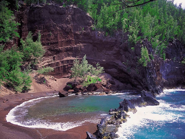
Beautiful red sand beach…near Hana, Maui
The trade winds may pick up a notch today into Friday, lasting through the weekend…and then slip a little as we move into the early part of next week. As this weather map shows, we find the long lasting 1029 millibar high pressure system located to the northeast of the
There will be periods of cloudiness across the islands, some of which will be dropping showers…although mostly along the windward sides and around the mountains. Looking at this IR satellite image, we see considerable clouds located just upstream of the windward sides to the east of Maui and the
Some interesting information came out today, the 2009-2010 Hawaiian Islands wet season ranked as the driest in the past 30 years. The recently completed October 2009 through April 2010 wet season also ranks as one of the driest in the past 55 years! The existing agricultural drought in the eastern half of the state worsened, especially in the Kona, Kau, and leeward Kohala districts on the Big Island. Impacts to agricultural operations span a wide range of sectors, including livestock, coffee, and ornamental flowers. Residents depending on rainfall catchment systems also suffered from the dry conditions, and required costly water delivery to meet basis needs.
It’s Thursday evening as I begin writing this last section of today’s narrative.
As noted above, the trade winds will be continuing, at least through the rest of this week, and likely through all of next week too. The paragraph above, provides notice of how dry we are here in the
Roz Says:
Glenn – just had to let you know how much we enjoyed our vacation on Maui. Never gave the possibility of rain a second thought–no chance of ruining this parade! The most rain we experienced was on the drive up/down Haleakala going through upcountry. I envy you and your daily walks.
Thanks for all the weather updates and hope to come back soon.
Roz~~~Hi Roz, great news, knowing that you didn’t have trouble with the rains down country, and enjoyed some water falling as you drove through the upcountry part of Maui. Oh yes, my daily morning and evening walks, I love them. Come back soon, Aloha, Glenn