


July 30-31, 2009
Air Temperatures – The following maximum temperatures were recorded across the state of Hawaii Thursday afternoon:
Lihue, Kauai – 83
Honolulu, Oahu – 89
Kaneohe, Oahu – 83
Kahului, Maui – 87
Hilo, Hawaii – 84
Kailua-kona – 87
Air Temperatures ranged between these warmest and coolest spots near sea level – and on the highest mountains…at 5 p.m. Thursday evening:
Kailua-kona – 79F
Hilo, Hawaii – 71
Haleakala Crater – 48 (near 10,000 feet on Maui)
Mauna Kea summit – 34 (near 14,000 feet on the Big Island)
Precipitation Totals – The following numbers represent the largest precipitation totals (inches) during the last 24 hours on each of the major islands, as of Thursday afternoon:
1.96 Mount Waialaele, Kauai
0.29 Manoa Valley, Oahu
0.01 Molokai
0.00 Lanai
0.00 Kahoolawe
0.51 Puu Kukui, Maui
0.36 Glenwood, Big Island
Marine Winds – Here’s the latest (automatically updated) weather map showing a high pressure system to the northeast of the islands Friday. This high pressure cell, along with its associated ridge to our north, will keep the trade winds blowing through Saturday.
Satellite and Radar Images: To view the cloud conditions we have here in Hawaii, please use the following satellite links, starting off with this Infrared Satellite Image of the islands to see all the clouds around the state during the day and night. This next image is one that gives close images of the islands only during the daytime hours, and is referred to as a Close-up visible image. This next image shows a larger view of the Pacific…giving perspective to the wider ranging cloud patterns in the Pacific Ocean. Finally, here’s a Looping IR satellite image, making viewable the clouds around the islands 24 hours a day. To help you keep track of where any showers may be around the islands, here’s the latest animated radar image.
Hawaii’s Mountains – Here’s a link to the live webcam on the summit of near 14,000 foot Mauna Kea on the Big Island of Hawaii. The tallest peak on the island of Maui is the Haleakala Crater, which is near 10,000 feet in elevation. These two webcams are available during the daylight hours here in the islands…and when there’s a big moon rising just after sunset for an hour or two! Plus, during the nights and early mornings you will be able to see stars, and the sunrise too…depending upon weather conditions.
Tropical Cyclone activity in the eastern and central Pacific – Here’s the latest weather information coming out of the National Hurricane Center, covering the eastern north Pacific. You can find the latest tropical cyclone information for the central north Pacific (where Hawaii is located) by clicking on this link to the Central Pacific Hurricane Center. Here’s a tracking map covering both the eastern and central Pacific Ocean. A satellite image, which shows the entire ocean area between Hawaii and the Mexican coast…can be found here.
Aloha Paragraphs
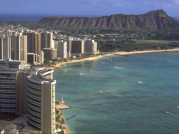
The famous Waikiki Beach…with Diamond Head Crater
The trade winds, despite being ever so slightly lighter now, will continue blowing through the rest of this work week…strengthening again by the weekend. A 1028 millibar high pressure system, located to the northeast of Hawaii, as shown on this weather map…is the source of our gusty breezes Thursday evening. It appears that our trade winds will extend well into the month of August. These refreshing trade winds will continue to moderate the afternoon heat near sea level.
The low pressure system over the islands, at upper levels of the atmosphere, will keep the chance of a heavy localized shower in the forecast into this evening. It looked as if the low prompted a few localized thunderstorms on the leeward slopes on the Big Island Thursday afternoon…and over the ocean north of Maui Thursday afternoon as well. This upper level trough of low pressure will fairly quickly lose its influence over our islands Friday into the weekend.
Strengthening tropical storm Lana may briefly reach hurricane strength, before weakening…as it passes south of the Hawaiian Islands. The hurricane models show that this storm should pass to the south of the Hawaiian Islands Sunday and Monday. Here’s a track map, showing the expected course of travel to our south. At this point there doesn’t appear to be a threat to the Hawaiian Islands. We will however find our local trade winds picking up in strength this weekend, as it moves by…and there’s a chance that some of this tropical storm’s precipitation might spread northward enough to clip the southern part of the Big Island. Here’s a satellite image showing this tropical cyclone to the southeast of the Hawaiian Islands.
It’s Thursday evening here in Kihei, Maui, as I begin writing this last part of this evening’s narrative. Our local trade winds may ease up a touch, but they won’t stay lighter for very long. As a matter of fact, as noted in the paragraphs above, they will become blustery again as we move into the weekend. The threat of locally heavy showers will be moving away soon, although there’s still the chance of a few downpours around Maui and the Big Island into the evening hours. The most interesting weather concern, I suppose we could call it that, will be strengthening tropical storm Lana, down to the southeast of the Hawaiian Islands. There’s a tracking map, and a satellite image available in the paragraph above. Current tropical storm Lana is expected to become a hurricane for part of the day Friday, but by the weekend, it should come under the influence of stronger winds aloft (a weakening process)…which should begin to shear the top layers of the tropical cyclone. I’ll have more to say about all this early Friday morning, when I get back online with your next new weather narrative. I hope you have a great Thursday night until then! Aloha for now…Glenn.
Interesting: The National Oceanic and Atmospheric Administration (NOAA) has published a final rule in the Federal Register prohibiting the harvesting of krill in the Exclusive Economic Zone (EEZ) off the coasts of California, Oregon, and Washington. The rule goes into effect on August 12, 2009. Krill are a small shrimp-like crustacean and a key source of nutrition in the marine food web.
"Krill are the foundation for a healthy marine ecosystem," said Mark Helvey, NOAA’s Fisheries Service Southwest Assistant Regional Administrator for Sustainable Fisheries. "Protecting this vital food resource will help protect and maintain marine resources and put federal regulations in line with West-Coast states."
While the States of California, Oregon and Washington currently have regulations prohibiting the harvesting of krill within three miles of their coastlines, there was no similar federal restriction within the three to 200-mile confines of the EEZ.
The krill prohibition was adopted as Amendment 12 to the Coastal Pelagic Species Fishery Management Plan (FMP), which was developed by the Pacific Fishery Management Council (PFMC) under the Magnuson-Stevens Fishery Conservation and Management Act.
The krill harvest prohibition was originally proposed to the PFMC and NOAA Fisheries Service by NOAA’s Office of National Marine Sanctuaries. Today’s rule implements Amendment 12 to the FMP and is intended to preserve key nutritional relationships in the California Current ecosystem, which includes five National Marine Sanctuaries.
"This is a great success for protecting the entire California Current ecosystem", said William Douros, West Coast Regional Director for NOAA’s Office of National Marine Sanctuaries. "This decision reflects strong teamwork within NOAA and a commitment to addressing the issues raised by the Pacific Fishery Management Council and Sanctuary Advisory Councils."
Interesting2: Rates of severe childhood obesity have tripled in the last 25 years, putting many children at risk for diabetes and heart disease, according to a report in Academic Pediatrics by an obesity expert at Brenner Children’s Hospital, part of Wake Forest University Baptist Medical Center. "Children are not only becoming obese, but becoming severely obese, which impacts their overall health," said Joseph Skelton, M.D., lead author and director of the Brenner FIT (Families in Training) Program.
"These findings reinforce the fact that medically-based programs to treat obesity are needed throughout the United States and insurance companies should be encouraged to cover this care." The research was published online and will appear in the September print edition. Skelton and colleagues compared data from the National Health and Nutrition Examination Survey (NHANES).
They looked at the prevalence of obesity and severe obesity in a study population of 12,384 children, representing approximately 71 million U.S. children ages 2 to 19 years. Severe childhood obesity is a new classification for children and describes those with a body mass index (BMI) that is equal to or greater than the 99th percentile for age and gender.
For example, a 10-year-old child with a BMI of 24 would be considered severely obese, Skelton said, whereas in an adult, that is considered a normal BMI. An expert committee convened by the American Medical Association, the Centers for Disease Control and the Department of Health and Human Services proposed the new classification in 2007.
Interesting3: A mobile pilot system could make preliminary feasibility tests for desalination easier and cheaper for developing countries. The system — known as ‘M3’ — can test whether fresh water can be extracted from almost any water source, said a team from the US-based University of California, Los Angeles (UCLA).
It harnesses a popular desalination technique known as reverse osmosis, a filtration process that forces water through a membrane, filtering out impurities. Desalination is often costly but the M3 system can cut costs.
Normally, a new static pilot plant must be constructed at every potential water source both to test water quality and to assess strategies for pre-treating water. Pre-treatment is needed to remove impurities before they pollute the reverse osmosis membranes.
These are costly to clean and replacing them, means shutting down desalination plants, Nidal Hilal, director of the Centre for Clean Water Technologies at Nottingham University, United Kingdom said. M3’s flexible and portable nature means that a country interested in desalination could buy one system and use it to test all potential water sources, says UCLA team leader Yoram Cohen — saving time as well as money.
Interesting4: Several years ago, it looked as though the United States was running short of natural gas. Prices spiked as declining production in old fields collided with increasing industrial demand. Electric utilities shifted from ‘clean’ gas back to cheap coal, and suppliers began building terminals to import liquefied natural gas from abroad.
Yet today, coal-fired power is again on the wane, ports for liquefied natural gas are idling below capacity, and the nation is awash with gas. So what happened? Clearly, the threat of carbon regulation has curbed industry’s appetite for coal, and the sagging economy has depressed energy demand across the board. But just as importantly, natural-gas production is again on the rise.
Thanks to advances in drilling technology, including horizontal drilling and more effective rock fracturing, producers have at last unlocked the vast quantities of gas trapped underground in impermeable strata of shale.
The Potential Gas Committee, a volunteer group of industry, government and academic experts headquartered in Golden, Colorado, increased its estimate of recoverable gas reserves by 39% in its biennial report released last month, mostly because of shale gas.
The new total, almost 60 trillion cubic meters, is equivalent to about a century’s worth of gas at current usage rates. Policy-makers everywhere should take note. Shale formations similar to those that have upended the US natural-gas market exist all over the world.
Early explorations are already under way in Canada and several European countries, many of which are overly reliant on coal and politically risky Russian gas imports. And there is no reason to think the development will stop there.
Interesting5: The growing shortage of water – a perennial problem in the world’s poorer nations – is expected to eventually reach the rich nations in the Western world. The United States, Spain, Australia and the Netherlands are likely to face the consequences of climate change resulting in water-related disasters, including droughts, floods, hurricanes and sea-level rise.
"Even the world’s richest nations are not immune," U.N. Secretary-General Ban Ki-moon warned Tuesday. Citing official U.S. figures, he said the state of California, the world’s fifth largest economy, "could see prime farmland reduced to a dustbowl, and major cities running out of water by the end of the century".
Blaming it on the negative impact of global warming, he said that climate is changing – globally. "And so, therefore, must we." He quoted scientists as saying that by 2020, 75 to 250 million people in Africa will face growing shortages of water due to climate change.
Interesting6: Among many reasons not to flush medicines down the drain or throw them out with the trash is to prevent the chemicals from decomposing in soil and water supplies. Chemicals are passed on to wildlife and humans consuming that water, and the chemicals may destroy important bacteria in soils and water that actually help purify those resources.
To date, wastewater treatment systems are not setup to remove those contaminants, and that does not consider the runoff leaking directly into bodies of water or consumed by wildlife.
In an effort to halt flushing and tossing, the National Association of Counties has adopted a resolution the "Support of a Safe, Convenient Medicine Return Program" that places at least some of the responsibility of proper medicine disposal on the vendors supplying medicine to consumers.
The Association is identifying non-governmental funds available to locate a pharmaceutical manufacturer who can collect medicine for proper disposal. Similar functioning efforts, known as take back programs, are working throughout communities in America and Canada.
In an era when nearly everyone is taking some sort of medication, popular prescriptions including anti-depressants, cholesterol controllers, and oral contraceptives, statistics are showing frightening rates of improper disposal. According to the investigative work conducted in informing the policy’s reviewers and decision makers, medicine metabolites are found in the drinking supplies of "24 major metropolitan areas affecting 41 million Americans."