


July 16-17, 2009
Air Temperatures – The following maximum temperatures were recorded across the state of Hawaii Thursday afternoon:
Lihue, Kauai – 83
Honolulu, Oahu – 90
Kaneohe, Oahu – 83
Kahului, Maui – 89
Hilo, Hawaii – 85
Kailua-kona – 86
Air Temperatures ranged between these warmest and coolest spots near sea level – and on the highest mountains…at 4 p.m. Thursday afternoon:
Honolulu, Oahu – 88F
Princeville, Kauai – 81
Haleakala Crater – 52 (near 10,000 feet on Maui)
Mauna Kea summit – 43 (near 14,000 feet on the Big Island)
Precipitation Totals – The following numbers represent the largest precipitation totals (inches) during the last 24 hours on each of the major islands, as of Thursday afternoon:
1.23 Mount Waialaele, Kauai
1.30 Poamoho 2, Oahu
0.03 Molokai
0.00 Lanai
0.01 Kahoolawe
0.71 West Wailuaiki, Maui
0.39 Honaunau, Big Island
Marine Winds – Here’s the latest (automatically updated) weather map showing high pressure systems to the north and northeast of the islands Friday. These high pressure cells, along with their associated high pressure ridges…will keep the trade winds blowing through Saturday.
Satellite and Radar Images: To view the cloud conditions we have here in Hawaii, please use the following satellite links, starting off with this Infrared Satellite Image of the islands to see all the clouds around the state during the day and night. This next image is one that gives close images of the islands only during the daytime hours, and is referred to as a Close-up visible image. This next image shows a larger view of the Pacific…giving perspective to the wider ranging cloud patterns in the Pacific Ocean. Finally, here’s a Looping IR satellite image, making viewable the clouds around the islands 24 hours a day. To help you keep track of where any showers may be around the islands, here’s the latest animated radar image.
Hawaii’s Mountains – Here’s a link to the live webcam on the summit of near 14,000 foot Mauna Kea on the Big Island of Hawaii. The tallest peak on the island of Maui is the Haleakala Crater, which is near 10,000 feet in elevation. These two webcams are available during the daylight hours here in the islands…and when there’s a big moon rising just after sunset for an hour or two! Plus, during the nights and early mornings you will be able to see stars, and the sunrise too…depending upon weather conditions.
Tropical Cyclone activity in the eastern and central Pacific – Here’s the latest weather information coming out of the National Hurricane Center, covering the eastern north Pacific. You can find the latest tropical cyclone information for the central north Pacific (where Hawaii is located) by clicking on this link to the Central Pacific Hurricane Center. Here’s a tracking map covering both the eastern and central Pacific Ocean. A satellite image, which shows the entire ocean area between Hawaii and the Mexican coast…can be found here.
Aloha Paragraphs
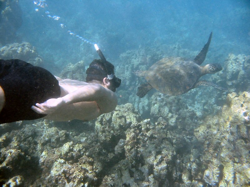
Snorkeling with the turtles
Trade wind weather conditions to continue across all of the Hawaiian Islands Friday into the weekend. The 1024 millibar high pressure system to the northeast of us Thursday evening, is the source of our moderately strong winds…as shown on this weather map. Our trade wind speeds will pick up a notch Friday into the weekend. As these winds gain that strength, we have already seen small craft wind advisories having gone up over those windier areas around Maui and the
Windward biased showers will continue, falling in the most generous manner during the nights…there could be a few heavy ones here and there. There continues to be some clouds upstream of the islands Thursday evening, which will keep off and on shower activity arriving along our windward coasts and slopes into Friday. We now find most of the high cirrus clouds steaming off the tops of thunderstorms over by the International Dateline. This satellite image shows that most of these cirrus clouds are located to the southeast the Big Island now.
Former tropical cyclone Carlos has now dissipated, while tropical depression Dolores, is baring hanging onto live by a thread in the eastern Pacific. Here’s the NHC forecast track for now retired Carlos, and Dolores. Here’s the best satellite image, showing both of these tropical systems in relation to Hawaii. Whatever few clouds that are left over with Carlos, will pass well south of the islands, while Dolores will be fading away…although there’s still the chance that we might get some showers from its remnant circulation next week about this time.
It’s Thursday evening here in Kihei, Maui, as I begin writing this last section of this evening’s narrative. As has been the case all this week, Thursday’s weather was near perfect. Yes, the trade winds were blowing, but those are what make our hot afternoon temperatures bearable at sea level locations. As you might have read in the paragraph above, former tropical cyclone Carlos is now been put in the history books, retired by the National Hurricane Center in Miami. They’re still working with tropical depression Dolores, in the eastern Pacific, but that too…should be over and out sometime soon. ~~~ Speaking of over and out, that’s the case with this Maui weatherman now. I’m just about ready to head up the mountain, to my haven in Kula. Make no mistake though, I’ll be up very early Friday morning, in order to prepare your next new weather narrative then. I hope you have a great Thursday night! Aloha for now…Glenn.
Interesting: Scientists at The Florida State University’s Center for Ocean-Atmospheric Prediction Studies (COAPS) have developed a new computer model that they hope will predict with unprecedented accuracy how many hurricanes will occur in a given season. After about five years developing and assessing the model, Associate Scholar Scientist Tim LaRow and his COAPS colleagues are putting the system to the test this year with their first-ever hurricane forecast.
The COAPS model is one of only a handful of so–called "dynamical models" in the world being used to study seasonal hurricane activity. The COAPS model has predicted a below-average season in the Atlantic Ocean, with a mean of eight named storms and four hurricanes based partially on emerging El Nino conditions.
During an El Nino, the warmer ocean temperatures in the tropical eastern Pacific tend to suppress hurricane activity in the Atlantic. The historical seasonal average is 11 tropical storms and six hurricanes. "Making a real-time forecast for the first time is always very interesting and a very good test of the model," LaRow said.
"The hard part is in the waiting to see how the model verifies." LaRow and COAPS researchers Lydia Stefanova and Dong-Wook Shin issued their forecast on June 1, the official start of the six-month hurricane season. The tropics traditionally don’t become active until the early fall months, so it’s too early to tell if the forecast is on track.
However, the researchers have good reason to feel confident. Before making this year’s prediction, they used the model to perform 20 years of re-forecasts, or hindcasts, using the sea surface temperatures determined by the National Oceanic and Atmospheric Administration on June 1 of every year from 1986 to 2005.
They found a very high correlation between the model’s predictions of the number and intensity of tropical cyclones and what actually occurred during those years. In addition, the model outperformed many statistical and other dynamical models, LaRow said.
Statistical models use statistical relationships between oceanic and atmospheric variables to make a forecast, while dynamical models, such as the COAPS model, require major computing resources in order to make trillions of calculations using the equations of motion along with the best physical understanding of the atmosphere.
The COAPS model uses the university’s high-performance computer to synthesize massive amounts of information including atmospheric, ocean and land data. A key component of the COAPS model is NOAA’s forecast of sea surface temperatures.
But COAPS researchers continue to study their own model in an effort to better understand the relationship between sea surface temperatures and climate predictability. "All models are unique, and what makes them unique is the physics inside them," LaRow said.
"How and why our model’s collection of physical processes captures the year-to-year variability so well needs to be better understood. This research will lead to even greater seasonal forecasting skill in the future." In 2006, COAPS received a $6.2 million, five-year grant from NOAA that has been used, in part, to support the development of this model.
Interesting2: Sweden is to become the first country to slap "climate-friendly" labels on food products. The hope is that the labels will prompt consumers to buy greener products, but there are worries that some companies may use the scheme to "greenwash".
A small milk producer north of Stockholm is expected to be the first company to sport the "climate-certified" tag. One way it cut its use of energy and nutrients was by switching from chemical-based fertilizers to manure. The scheme is voluntary and firms must prove they have reduced greenhouse gas emissions in order to earn a label.
"The only thing we’re guaranteeing is that improvements have been made," says Anna Richert, an adviser to the Federation of Swedish Farmers (LRF), and head of the team developing the criteria for labeling products. "This could mean reductions in emissions of anything from 5 to 80 per cent."
Interesting3: For the first time, NOAA scientists have demonstrated that tsunamis in the open ocean can change sea surface texture in a way that can be measured by satellite-borne radars. The finding could one day help save lives through improved detection and forecasting of tsunami intensity and direction at the ocean surface.
“We’ve found that roughness of the surface water provides a good measure of the true strength of the tsunami along its entire leading edge. This is the first time that we can see tsunami propagation in this way across the open ocean,” said lead author Oleg Godin of NOAA’s Earth System Research Laboratory and the Cooperative Institute for Research in Environmental Sciences, in Boulder, Colo.
Large tsunamis crossing the open ocean stir up and darken the surface waters along the leading edge of the wave, according to the study. The rougher water forms a long, shadow-like strip parallel to the wave and proportional to the strength of the tsunami. That shadow can be measured by orbiting radars and may one day help scientists improve early warning systems.
The research is published online this week in the journal, Natural Hazards and Earth System Sciences. The new research challenges the traditional belief that tsunamis are too subtle in the open ocean to be seen at the surface.
The findings confirm a theory, developed by Godin and published in 2002-05, that tsunamis in the deep ocean can be detected remotely through changes in surface roughness. In 1994, a tsunami shadow was captured by video from shore moments before the wave struck Hawaii.
That observation and earlier written documentation of a shadow that accompanied a deadly tsunami on April 1, 1946, inspired Godin to develop his theory. He tested the theory during the deadly December 26, 2004, Indian Ocean tsunami, the result of the Sumatra-Andaman earthquake.
Godin and colleagues analyzed altimeter measurements of the 2004 tsunami from NASA’s Jason-1 satellite. The data revealed clear evidence of an increased surface roughness along the leading edge of the tsunami as it passed across the Indian Ocean between two and six degrees south latitude.
Tsunamis can be detected in several ways. One detection method uses a buoy system that warns coastal communities in the United States of an approaching tsunami. NOAA’s Deep-ocean Assessment and Reporting of Tsunamis (DART) early warning system uses sensors on the ocean floor to measure changes in pressure at each location.
The DART network of 39 stations extends around the perimeter of the Pacific Ocean and along the western edge of the North Atlantic Ocean and Gulf of Mexico. The technology provides accurate, real-time information on the amplitude, over time, of an approaching tsunami. NOAA’s tsunami warning centers then use this information to forecast the tsunami’s impact on coastlines.
A second method uses space-borne altimeters to detect tsunamis by measuring small changes in sea surface height. Only a handful of these instruments are in orbit and the observations are limited to points along a line. The new study presents a third way to detect tsunamis — by changes in the texture of the surface water across a wide span of the open ocean.
Godin’s research confirmed his theory that a tsunami wave roughens the surface water through air-sea interaction. First the leading edge of the tsunami wave stirs up the surface winds. Those same winds, which become more chaotic than the wave itself, then churn the surface waters along the slope of the wave.
Because rough water is darker than smooth water, a contrast forms between the dark, rough water of the wave and the bright, smooth water on either side of it. Common scientific instruments, called microwave radars and radiometers, are able to detect this contrast, known as a tsunami shadow.
When orbiting the Earth, microwave radars and radiometers can observe a band of ocean surface hundreds of kilometers wide and thousands of kilometers long. If programmed correctly to observe sea surface roughness, they could potentially map an entire tsunami, said Godin.
Interesting4: The world will remain heavily dependent on fossil fuels such as oil, gas and coal for the rest of this century, despite the best efforts of governments to move toward renewable energy, an energy economist said on Wednesday. Peter Odell, professor of international energy studies at Erasmus University, Rotterdam, and author of the bestselling World and Oil Power, said the drive to limit greenhouse gases was likely to be held back by both technology and economics. Painting a gloomy picture of the short-term outlook for renewables, Odell told Reuters that even with a growing global effort to limit carbon dioxide emissions, the world would still be relying on hydrocarbons by 2100.
Interesting5: Thousands of jumbo flying squid — aggressive 5-foot-long sea monsters with razor-sharp beaks and toothy tentacles — have invaded the shallow waters off San Diego, spooking scuba divers and washing up dead on tourist-packed beaches. The carnivorous calamari, which can grow up to 100 pounds, came up from the depths last week and swarms of them roughed up unsuspecting divers. Some divers report tentacles enveloping their masks and yanking at their cameras and gear.
Stories of too-close encounters with the alien-like cephalopods have chased many veteran divers out of the water and created a whirlwind of excitement among the rest, who are torn between their personal safety and the once-in-a-lifetime chance to swim with the deep-sea giants.
The so-called Humboldt squid, which can grow up to 100 pounds, are native to the deep waters off Mexico, where they have been known to attack humans and are nicknamed "red devils" for their rust-red coloring and mean streak.
Those who dive with them there chum the water with bait and sometimes get in a metal cage or wear chain mail to avoid being lashed by tentacles. "I wouldn’t go into the water with them for the same reason I wouldn’t walk into a pride of lions on the Serengeti," said Mike Bear, a local diver.
"For all I know, I’m missing the experience of a lifetime." The squid are too deep to bother swimmers and surfers, but many longtime divers say they are staying out of the surf until the sea creatures clear out.
Yet other divers, including Shandra Magill, couldn’t resist the chance to see the squid up close. On a recent night, Magill watched in awe as a dozen squid with doleful, expressive eyes circled her group, tapping and patting the divers and gently bumping them before dashing away.
One especially large squid suspended itself motionless in the water about three feet away and peered at her closely, its eyes rolling, before it vanished into the black. A shimmering incandescence rippled along its body, almost as if it were communicating through its skin.
But the next night, things were different: A large squid surprised Magill by hitting her from behind and grabbing at her with its arms, pulling her sideways in the water. The powerful creature ripped her buoyancy hose away from her chest and knocked away her light. When Magill recovered, she didn’t know which direction was up and at first couldn’t find the hose to help her rise to the surface.
The squid was gone. "I just kicked like crazy. The first thing you think of is, ‘Oh my gosh, I don’t know if I’m going to survive this. If that squid wanted to hurt me, it would have," she said. Other divers have reported squid pulling at their masks and gear and roughing them up.