


February 3-4, 2009
Air Temperatures – The following maximum temperatures were recorded across the state of Hawaii Tuesday afternoon:
Lihue, Kauai – 70
Honolulu, Oahu – 75
Kaneohe, Oahu – 72
Kahului, Maui – 71
Hilo, Hawaii – 71
Kailua-kona – 82
Air Temperatures ranged between these warmest and coolest spots near sea level, and on the highest mountains…at 4 p.m. Tuesday afternoon:
Barking Sands, Kauai – 79F
Molokai airport – 67
Haleakala Crater – 46 (near 10,000 feet on Maui)
Mauna Kea summit – 36 (near 14,000 feet on the Big Island)
Precipitation Totals – The following numbers represent the largest precipitation totals (inches) during the last 24 hours on each of the major islands, as of Tuesday afternoon:
2.01 Mount Waialaele, Kauai
5.76 Oahu Forest NWR, Oahu
1.61 Molokai
0.03 Lanai
0.01 Kahoolawe
7.03 West Wailuaiki, Maui
5.29 Honokaa, Big Island
Weather Chart – Here’s the latest (automatically updated) weather map showing a relatively close 1032 millibar high pressure system to the north of the Hawaiian Islands Wednesday. Our winds will remain out of the trade wind direction…gusty into Wednesday and Thursday.
Satellite and Radar Images: To view the cloud conditions we have here in Hawaii, please use the following satellite links, starting off with the Infrared Satellite Image of the islands to see all the clouds around the state during the day and night. This next image is one that gives close images of the islands only during the daytime hours, and is referred to as a Close-up visible image. This next image shows a larger view of the Pacific…giving perspective to the wider ranging cloud patterns in the Pacific Ocean. Finally, here’s a looping IR satellite image, making viewable the clouds around the islands 24 hours a day. To help you keep track of where any showers may be around the islands, here’s the latest animated radar image.
Hawaii’s Mountains – Here’s a link to the live webcam on the summit of near 14,000 foot Mauna Kea on the Big Island of Hawaii. The tallest peak on the island of Maui is the Haleakala Crater, which is near 10,000 feet in elevation. These two webcams are available during the daylight hours here in the islands…and when there’s a big moon rising just after sunset for an hour or two! Plus, during the nights and early mornings you will be able to see stars, and the sunrise too…depending upon weather conditions.
Aloha Paragraphs
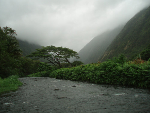
Cool and breezy – showers windward sides
Photo Credit: flickr.com
The trade winds remain blustery as expected, which will remain active through Wednesday…becoming lighter Thursday into the weekend. All of Hawaii’s coastal and channel waters still have small craft wind advisories, which will remain active into mid-week. As we move into the second half of this work week, our winds will become somewhat lighter. The computer models continue to show lighter winds this weekend, coming in from the east-southeast or southeast. Volcanic haze is often carried over the state, from the Big Island vents during SE wind episodes…which may become a part of our Hawaiian Island weather picture then.
Generous rainfall amounts continue to be brought into the state on the blustery northeast trade winds. The windward sides have seen the greatest share of these trade wind showers. Although, with the stronger winds blowing, the leeward sides have seen some showers falling locally too. Weather conditions will improve on Thursday, especially along the south and west facing beaches. Lighter winds from the southeast, as we get to the weekend, will cause afternoon upcountry convective shower activity…some of which may be locally generous.
It’s Tuesday evening here in Kihei, Maui, as I begin writing this last section of today’s narrative. The inclement weather conditions, at least on the north and east facing windward sides remains active now. These inclement weather conditions will prevail into Wednesday, with gradually improving conditions Thursday onward. Here’s a satellite image, so you can keep an eye on the clouds moving through the state. As you can see, we continue to find large amounts of high cirrus clouds streaming overhead. Here’s a looping radar image as well, so that you can see where the showers are being carried in…on the cool northeast wind flow.
~~~ Orographic precipitation continues to gather over the windward coasts and slopes Tuesday evening. Orographic simply means that moisture being carried in on the trade winds, rises as it impacts the slopes of our volcanic islands, with clouds and showers dumping rainfall there. I used the word dumping on purpose, due to the generous rainfall totals being noted along those slopes during the last 24 hours…as of late Tuesday afternoon. Here’s a few examples: 2.01" in the mountains on Kauai; 5.76" over the mountains on Oahu; 1.61" on Molokai; 4.69" over the West Maui Mountains…7.03" over the windward side of east Maui; and finally the 5.29" on the Big Island.
~~~ Tuesday was not a banner day for sunshine here in the islands, far from it as a matter of fact! If you had a chance, or can spare a few seconds now, you can click on the satellite image above, that we have a ton of high clouds streaming overhead. These icy clouds are being pushed in our direction by an upper level trough of low pressure just to our southwest. The counterclockwise rotation around this trough, is carrying this sun dimming and filter, high level moisture over our islands. This cloudiness, in addition to the cool northeast winds, kept our high temperatures on the low side again today…topping out at near record low levels in many areas! The rainfall during the last 24 hours, at a rain gauge along the Hana Highway, here on Maui, measured over 7.00" of the wet stuff! It was a windy, cloudy, and locally wet day here in paradise Tuesday!
~~~ I’m about ready to head out, on my drive back upcountry to Kula. Looking out the window here in Kihei, before I leave at near 530pm, its just about totally cloudy out there. I do see a very small break in the clouds, with the slightest bit of blue sky showing through the otherwise overcast skies. I’d like to say that our weather will improve Wednesday, but I’m afraid that we’ll likely have to wait until Thursday, before we see any substantial changes. Nonetheless, I’d like to wish you well, and at the same time invite you back again Wednesday. I hope you have a great Tuesday night until then! Aloha for now…Glenn.
Interesting: Some bio-fuels cause more health problems than petrol and diesel, according to scientists who have calculated the health costs associated with different types of fuel. The study shows that corn-based bio-ethanol, which is produced extensively in the US, has a higher combined environmental and health burden than conventional fuels. However, there are high hopes for the next generation of bio-fuels, which can be made from organic waste or plants grown on marginal land that is not used to grow foods. They have less than half the combined health and environmental costs of standard gasoline and a third of current bio-fuels. The work adds to an increasing body of research raising concerns about the impact of modern corn-based bio-fuels. Several studies last year showed that growing corn to make ethanol bio-fuels was pushing up the price of food. Environmentalists have highlighted other problems such deforestation to clear land for growing crops to make the fuels. The UK governments renewable fuels advisors recommended slowing down the adoption of bio-fuels until better controls were in place to prevent inadvertent climate impacts.
Using computer models developed by the US Environmental Protection Agency, the researchers found the total environmental and health costs of gasoline are about 71 cents per gallon, while an equivalent amount of corn-ethanol fuel has associated costs of 72 cents to $1.45, depending on how it is produced. The next generation of so-called cellulosic bio-ethanol fuels costs 19 cents to 32 cents, depending on the technology and type of raw materials used. These are experimental fuels made from woody crops that typically do not compete with conventional agriculture. The results are published online today in the Proceedings of the National Academy of Sciences. "The dialogue so far on bio-fuels has been pretty much focused on greenhouse gases alone," said David Tilman, a professor at the department of ecology, evolution and behavior at the University of Minnesota. "And yet we felt there were many other impacts that were positive or negative not being included. We wanted to expand the analysis from greenhouse gases to at least one other item and we chose health impacts."
Interesting2: The specter of an ocean floor littered with dead shellfish, rock fish, sea stars and other marine life off the Oregon coast spurred Mark Snyder, a climate change expert, to investigate whether California’s coast faced a similar calamity. It could, the University of California Santa Cruz earth scientist said, citing climate change, which some scientists believe is responsible for stronger and more persistent winds along the coast. There’s no debate that windier conditions drive more upwelling of nutrient-rich deep ocean waters. At normal levels, this upwelling sustains the abundance of marine life, but too much of these rich waters leads to a boom-and-bust cycle that ultimately creates ocean "dead zones" with little or no oxygen. Marine life that can’t swim or scuttle away from these lethal zones suffocate.
To assess future wind and upwelling scenarios along the California coast, Snyder and his colleagues at UC Santa Cruz ran climate simulations for two time periods. One spanned from 1968 to 2000, verifying the accuracy of the modeling. The second simulated the region’s estimated climate from 2038 to 2070, using the intergovernmental panel on climate change "high-growth" emissions projections. Snyder said he chose the high emissions scenario because todays are exceeding earlier IPCC estimates. The results showed increases in wind speeds of as much as 2 meters per second, a 40% increase from current wind speeds, which now average 5 meters per second, Snyder said. The change in wind speeds is already happening, Snyder said. California winds have been growing in strength in the past 30 years. Snyder said he knows his hypothesis needs more research, so he’ll know whether to continue pursuing it or to discard it. The latter is unlikely, he said, given the new cycle of dead zones on the Oregon and Washington coasts that started in 2002.
Interesting3: Google Earth allows web users to explore world’s oceans in 3D. The Ocean tool combines renderings of underwater terrain with expert content from marine biologists and oceanographers, allowing web surfers to swim around virtual underwater volcanoes, watch videos about exotic marine life, read about nearby shipwrecks, and contribute photos and videos of their favorite diving spots. Google said that humans had only ever explored around five per cent of the world’s oceans, which cover more than 70 per cent of the earth’s surface and contain 80 per cent of all life. Eric Schmidt, Google’s chief executive, said the launch of Ocean in Google Earth provided an opportunity to change people’s perspective about the importance of the oceanic ecosystem in the overall health of the planet. "In discussions about climate change, the world’s oceans are often overlooked, despite being an integral part of the issue," he said. "Biodiversity loss in our oceans in the next 20 to 30 years will be roughly equivalent to losing an entire Amazon rainforest, but this goes unnoticed because we can’t see it."
The Ocean feature is included in the newest version of Google Earth. As users zoom in on the ocean they will see a dynamic water surface, which they can then "dive" beneath to navigate the sea floor. Areas available for exploration include the Mid-Ocean Ridge, the world’s longest underwater mountain range, which stretches 50,000km around the globe.Many of the world’s leading scientists, researchers and ocean explorers have contributed to the fact files, videos and information sheets within the tool. There is even new and unseen footage from the archives of Jacques Cousteau, as well as the ability to track satellite-tagged sea animals, such as whales.
Interesting4: Your mother always told you not to use your teeth as tools to open something hard, and she was right. Human skulls have small faces and teeth and are not well-equipped to bite down forcefully on hard objects. Not so of our earliest ancestors, say scientists. New research published in the February 2009 issue of Proceedings of the National Academy of Sciences reveals nut-cracking abilities in our 250-million-year-old relatives that enabled them to alter their diet to adapt to changes in food sources in their environment. Mark Spencer, an Arizona State University assistant professor, and doctoral student Caitlin Schrein in ASU’s School of Human Evolution and Social Change, are part of the international team of researchers who devised the study featured in the article "The feeding biomechanics and dietary ecology of Australopithecus africanus." Using state-of-the-art computer modeling and simulation technology – the same kind engineers use to simulate how a car reacts to forces in a front-end collision – evolutionary scientists built a virtual model of the A. africanus skull and were able to see just how the jaw operated and what forces it could produce.
"We started with a CT scan of a skull that is one of the most complete specimens of A. africanus that we have," said Spencer, researcher in ASU’s Institute of Human Origins and a lead investigator on the project, which was funded by the National Science Foundation and European Union. This would be a later ancestor of Lucy – STS5 – who is affectionately known as "Mrs. Ples." The skull, discovered in 1947, has struts on the side of the nose, but no teeth. "We meshed those data with another specimen with teeth to make the virtual model of the bone and tooth structure. "Then we looked at chimpanzees, who share common features with Australopithecus, and took measurements of how their muscles work and added that to the model. We were able to validate this model by comparing it to a similar model built for a species of monkey called macaques," Spencer explained. The result – a rainbow colored virtual skull that illustrates forces absorbed by the cranial structure in simulated bite scenarios and how their unusual facial features were ideally suited to support the heavy loads of cracking hard nuts.
Interesting5: More energy from wind power came online in Europe in 2008 than from any other energy source, the European Wind Energy Association (EWEA) reported recently. Of new energy-generating capacity that went online in that year, 43 per cent came from wind power, the group said. That meant an average of 20 wind turbines installed every working day of that year. The growth in production capacity means about 4.2 per cent of Europe’s energy demand will come from wind power. The group says that will mean 108 million tonnes less in carbon dioxide emissions a year, the equivalent of taking more than 50 million cars off European roads. "The figures show that wind energy is the undisputed number one choice in Europe’s efforts to move towards clean, indigenous renewable power," said Christian Kjaer, EWEA’s chief executive. The group said it saw the most growth in Germany and Spain. The group also said it was seeing market growth in eastern Europe.
Interesting6: It is 3 degrees and snowing outside the Alaska Volcano Observatory in Anchorage, but inside the operations center, things are heating up. "This is kind of the nerve center, if you will," says geologist Michelle Coombs, who is at the helm of a bank of video monitors showing readouts from sensors on Mount Redoubt, a volcano about 100 miles southwest of Anchorage. The sensors measure seismic activity on the volcano’s summit. Scientists at the observatory combine that information with data gathered from daily airplane flights to the volcano to measure gases and try to figure out if and when Redoubt is going to blow. "We’re seeing lots of little earthquakes right now," says Coombs. "As that magma rises, it breaks rock as it gets to the surface, and it also it gives off gases, and that leads to the seismic activities were seeing now."
When the magma, or molten rock, makes it to the surface, the volcano will erupt. A siren goes off, and one of the video monitors goes haywire. Is the mountain erupting? "That’s just a little alarm. There was just a little bit of increased seismic activity," Coombs says reassuringly. "It’s a special kind of earthquake particular to volcanoes called a long-period earthquake. It has more to do with fluid and gases than with breaking rock." Since the monitors first showed increased activity on January 23, the observatory has been staffed 24 hours a day. Scientists here are calling in reinforcements; several geologists from the Lower 48 have been making their way north to help.
Coombs thinks Redoubt will erupt within days or weeks. No one lives near the mountain, which sits on the Cook Inlet and is largely surrounded by glacier ice. That means there is no direct danger from lava flows, but huge clouds of ash could spread throughout Alaska. When Redoubt last erupted in 1989, it spread ash across Alaska for five months. "Geologists like to use the past as a key to the future, and previous historical eruptions of Redoubt have produced ash clouds of up to 40,000 feet above sea level," says Coombs. She notes that at current weather conditions, "it would take about three hours for that ash to leave the volcano and arrive in Anchorage." The ash is composed largely of silica, which is similar to tiny fragments of glass.
Down on the ground, the ash can be dangerous to breathe in and can damage cars as their engines draw the ash into their engines. But it is usually a nuisance. However, in the sky, the ash clouds can create very dangerous flying conditions for jets. "For jet aviation, it’s a very severe hazard because jet engines run at a very high temperature. And once that silica-rich ash gets ingested into the engine, it can re-melt and coat the insides of the engines and freeze up those engines," says Coombs. "That’s really the major thing we are trying to avoid here." The day after the 1989 eruption of Redoubt, a 747 flew into an ash cloud near Anchorage and all four engines stalled. The pilot was able to get two of the engines restarted, and the plane landed safely. Coombs says airspace around the volcano and Anchorage may be closed if Redoubt erupts.
Interesting7: Mexico City shut down a main water pipeline under a new conservation program, cutting service to more than 2 million residents Sunday after some reservoirs dropped to their lowest levels in 16 years. The Mexico City government and the National Water Commission will interrupt service for three days every month until May, when the rainy season begins. Mexico City’s government says the plan will affect everyone from those living in million-dollar mansions to cement hovels. Another 13 cities in the metro area of 20 million also will see service reduced, the National Water Commission said. To prepare for the three-day shutdown, which ends Tuesday, residents filled underground cisterns, saved water in buckets to bathe and were flushing toilets and doing the wash only when necessary. Saleswoman Amanda Sanchez, 46, was not happy about having her taps shut off. "It’s hard, especially for working mothers like me, because I use more water on the weekends," she said. Even before this weekend, some residents have had virtually no running water because of the poor condition of their pipes. City water pipes are so leaky, experts estimate 40 percent of drinking water is lost, and nearly all Mexico City’s abundant rainfall simply flows into sewage drains. The shut-off also will allow authorities to make much-needed repairs to the pipelines.
Interesting8: More than 47 million years ago, a whale was about to give birth to her young … on land. That’s according to skeletal remains of a pregnant cetacean whose fetus was positioned head-down as is the case for land mammals but not aquatic whales. The teeth of the fetus were so well-developed that researcher’s who analyzed the fossils think the baby would have been born within days, had its mom not died. The fossil discovery marks the first extinct whale and fetus combination known to date, shedding light on the lifestyle of ancient whales as they made the transition from land to sea during the Eocene Epoch (between 54.8 million and 33.7 million years ago). Philip Gingerich, a paleontologist at the University of Michigan, Ann Arbor, and his team discovered the pregnant whale remains in Pakistan in 2000, and then in 2004, Gingerich’s co-authors and others found the nearly complete skeleton of an adult male from the same species in those fossil beds. The adult whales are each about 8.5 feet long and weighed between 615 and 860 pounds, though the male was slightly longer and heavier than the female.
Interesting9: The Earth’s seasons have shifted back in the calendar year, with the hottest and coldest days of the years now occurring almost two days earlier, a new study finds. This shift could be the work of global warming, the researchers say. To figure this out, scientists at the University of California, Berkeley and Harvard studied temperature data from 1850 to 2007 compiled by the University of East Anglia’s Climate Research Unit in the United Kingdom. They found that temperatures over land in the 100-year period between 1850 and 1950 showed a simple, natural pattern of variability, with the hottest day of the year in the Northern Hemisphere landing around July 21. But from the mid-1950s onward (the period when global average temperatures began to rise), the hottest day came 1.7 days earlier. This shift is happening at the same time that those summer and winter peaks are getting warmer and the gap between them is closing (because winter temperatures are rising faster than summer ones).
And with this shift of peak warming and cooling comes a corresponding shift in the onset of the seasons, which the researchers say explains the month-to-month pattern of temperatures over the past 50 years. "Once we have accounted for the fact that the temperature averaged over any given year is increasing, we find that some months have been warming more than other months," said Alexander Stine, a graduate student at UC Berkeley. "We were surprised to find that over land, most of the difference in the warming of one month relative to another is simply the result of this shift in the timing of the seasons, and a decrease in the difference between summer and winter temperatures." In recent years, scientists have noted other signs that the seasons are shifting: some birds are migrating earlier; plants are blooming earlier; mountain snows are melting earlier. The timing of the shift along with the rise in global temperatures leads Stine and his colleagues to think that human-caused climate change is the ultimate cause behind the shift. But exactly which effects of global warming are driving the shift is less clear.