2008
Yearly Archive
Posted by Glenn
No Comments
March 28-29 2008
Air Temperatures – The following maximum temperatures were recorded across the state of Hawaii Friday:
Lihue, Kauai – 82
Honolulu, Oahu – 84
Kaneohe, Oahu – 79
Kahului, Maui – 81
Hilo, Hawaii – 78
Kailua-Kona, Hawaii – 83
Temperatures ranged between these warmest and coolest spots near sea level at 4 p.m. Friday afternoon:
Barking Sands, Kauai – 82F
Molokai airport – 74
Precipitation Totals – The following numbers represent the largest precipitation totals (inches) during the last 24 hours on each of the major islands, as of Friday afternoon:
0.19 MOUNT WAIALEALE, KAUAI
0.33 POAMOHO 2, OAHU
0.02 MOLOKAI
0.00 LANAI
0.00 KAHOOLAWE
0.50 WEST WAILUAIKI, MAUI
0.32 GLENWOOD, BIG ISLAND
Weather Chart – Here’s the latest (automatically updated) weather map. A 1027 millibar high pressure system is located far to the northeast of Hawaii, which will keep moderately strong trade winds blowing…locally stronger and gusty in those usual windiest spots through Saturday.
Satellite and Radar Images: To view the cloud conditions we have here in Hawaii, please use the following satellite links, starting off with the Infrared Satellite Image of the islands to see all the clouds around the state during the day and night. This next image is one that gives close images of the islands only during the daytime hours, and is referred to as a Close-up visible image. This next image shows a larger view of the Pacific…giving perspective to the wider ranging cloud patterns in the Pacific Ocean…out from the islands. To help you keep track of where any showers may be around the islands, here’s the latest animated radar image.
Hawaii’s Mountains – Here’s a link to the live webcam on the summit of near 14,000 foot Mauna Kea on the Big Island of Hawaii. The tallest peak on the island of Maui is the Haleakala Crater, which is near 10,000 feet in elevation. These two webcams are available during the daylight hours here in the islands…and when there’s a big moon rising just after sunset for an hour or two! Plus, during the nights and early mornings you will be able to see stars, and the sunrise too…depending upon cloud conditions.
Aloha Paragraphs
 Hanalei Valley, Kauai lookout…with shower
Photo Credit: flikr.com
The trade winds will boost up some into the weekend…continuing on into next week. Weather maps show a 1027 millibar high pressure system far to the northeast of Hawaii Friday evening. This high will provide moderately strong to fresh trade winds across our tropical latitudes through most of the next week. Those typically windiest areas will see somewhat stronger and gusty conditions, especially during the afternoon hours. The winds remain strong enough now, that small craft wind advisory flags are active in the channels between Molokai and Maui, and between Maui and the Big Island…and the waters along the leeward side of the Big Island.
A few windward showers will continue to ride in on the gusty trade winds, while the leeward areas will continue to be mostly dry. The night and early morning hours will find the most common windward biased showers. The leeward sides will remain quite sunny and dry during the days. The Kona coast and slopes of the Big Island, may see some late afternoon, or early evening showers falling locally. There are no organized rain areas taking aim on our islands. These favorably inclined weather circumstances are expected to continue well into the new week ahead.
It’s Friday evening as I begin writing this last paragraph of today’s narrative. Other than the locally strong and gusty trade winds, and those occasional passing showers along the windward sides, our weather will remain quite nice. Looking at this looping satellite image, we can see that there are still lots of cirrus clouds coming up out of the deeper tropics to our west and southwest. We will see streaks of this high cloudiness being blown across our island skies at times over the next couple of days. ~~~ We find ourselves involved with a prolonged period of the trade winds. This trade wind weather pattern looks to be quite stable, with little day to day variation in this favorably inclined theme, well into the future. In a nutshell, nice springtime weather will prevail here in the Hawaiian Islands, with no definite end in sight at this time. ~~~ I going to see a new film this evening in Kahului, Maui, called 21 (2008)…starring Kevin Spacey, Jim Sturgess, Kate Bosworth, Laurence Fishburne, among many others. It’s being called a drama, about the true story of a team of gifted MIT students who learned how to turn blackjack odds to their favor, and took Vegas for millions. The credits are not raving about this film, and as a matter of fact are giving a straight C, while the viewers are giving a little more favorable B- grade. I guess I don’t have overly high hopes of being incredibly entertained, although that isn’t stopping me from going anyway. It seems that I almost always enjoy a new film, I suppose I’m easily pleased. At any rate, I’ll let you know early Saturday morning, when I’m back online with your next new narrative, what I thought. Here’s a trailer for the film, so you can formulate your own, at least, limited opinion. I hope you have a great Friday night until then! Aloha for now…Glenn.
Interesting: The U.S. West is heating up at nearly twice the rate of the rest of the world and is likely to face more drought conditions in many of its fast-growing cities. By analyzing federal government temperature data, the Natural Resources Defense Council concluded that the average temperature in the 11-state Western region from 2003-07 was 1.7 degrees Fahrenheit (0.94 degrees Celsius) higher than the historical average of the 20th century. The global average increase for the same period was 1.0 degrees Fahrenheit (0.55 degrees Celsius). In the Colorado River Basin, which supplies water to big and fast-growing cities like Los Angeles, San Diego, Las Vegas and Denver, the average temperature rose 2.2 degrees Fahrenheit (1.21 degrees Celsius), the U.S. group said.
Most of the river’s water comes from melting snow in the mountains, and climate scientists predict hotter temperatures will reduce the snow pack and increase evaporation, the NRDC said in a statement. "Global warming is hitting the West hard," said Theo Spencer of the NRDC. "It is already taking an economic toll on the region’s tourism, recreation, skiing, hunting and fishing activities." Study author Stephen Saunders of the Rocky Mountain Climate Organization said there were signs of the economic impacts throughout the West.
Interesting2: Farmer James Stirton found a odd-shaped ball last year on his 40,000 hectare property, about 500 miles west of the northern Queensland state capital of Brisbane. But Stirton only started inquiring into what the ball of metal really was, and where it had come from, in the past week. "I was riding out to check some cattle, and I came around the corner and there it was in a paddock," Stirton told Reuters on Friday. "I know a lot of about sheep and cattle but I don’t know much about satellites. But I would say it is a fuel cell off some stage of a rocket." He said the object was hollow, and covered in a carbon-fiber material. He has contacted some U.S.-based aerospace companies to try to find out what the object really is. Sydney‘s Powerhouse Museum said it was not uncommon for people to find spacejunk in remote areas of Australia. In 1979, large parts of the Skylab space station fell to earth near a tiny outback town in Australia‘s west. A local council sent NASA a ticket for littering and then the United States President Jimmy Carter rang a local motel to apologize.
Posted by Glenn
No Comments
March 27-28 2008
Air Temperatures – The following maximum temperatures were recorded across the state of Hawaii Thursday:
Lihue, Kauai – 81
Honolulu, Oahu – 85
Kaneohe, Oahu – 79
Kahului, Maui – 84
Hilo, Hawaii – 81
Kailua-Kona, Hawaii – 83
Temperatures ranged between these warmest and coolest spots near sea level at 4 p.m. Thursday afternoon:
Kahului, Maui – 82F
Molokai airport – 76
Precipitation Totals – The following numbers represent the largest precipitation totals (inches) during the last 24 hours on each of the major islands, as of Thursday afternoon:
0.19 MOUNT WAIALEALE, KAUAI
0.36 MANOA LYON ARBORETUM, OAHU
0.03 MOLOKAI
0.02 LANAI
0.00 KAHOOLAWE
0.18 PUU KUKUI, MAUI
0.32 KAPAPALA RANCH, BIG ISLAND
Weather Chart – Here’s the latest (automatically updated) weather map. A 1030 millibar high pressure system is located far to the northeast of Hawaii, which will keep moderately strong trade winds blowing…locally stronger and gusty in those usual windiest spots through Saturday.
Satellite and Radar Images: To view the cloud conditions we have here in Hawaii, please use the following satellite links, starting off with the Infrared Satellite Image of the islands to see all the clouds around the state during the day and night. This next image is one that gives close images of the islands only during the daytime hours, and is referred to as a Close-up visible image. This next image shows a larger view of the Pacific…giving perspective to the wider ranging cloud patterns in the Pacific Ocean…out from the islands. To help you keep track of where any showers may be around the islands, here’s the latest animated radar image.
Hawaii’s Mountains – Here’s a link to the live webcam on the summit of near 14,000 foot Mauna Kea on the Big Island of Hawaii. The tallest peak on the island of Maui is the Haleakala Crater, which is near 10,000 feet in elevation. These two webcams are available during the daylight hours here in the islands…and when there’s a big moon rising just after sunset for an hour or two! Plus, during the nights and early mornings you will be able to see stars, and the sunrise too…depending upon cloud conditions.
Aloha Paragraphs
 Iao Valley, looking towards Kahului, Maui
Photo Credit: flikr.com
The trade winds will prevail through the next week at least…increasing in strength some Friday into the weekend. Weather maps show a 1031 millibar high pressure system far to the northeast of Hawaii Thursday evening. This high will provide moderately strong trade winds across our tropical latitudes through Friday. Those typically windiest areas will see somewhat stronger and gusty conditions, especially during the afternoon hours. The winds are already a little stronger now, which has necessitated small craft wind advisory flags to go up in the channels between Molokai and Maui, and between Maui and the Big Island…and the waters along the leeward side of the Big Island.
Rather dry weather will continue, with most of whatever few showers that fall…occurring along the windward sides of the islands. The night and early morning hours will have the greatest likelihood of these few occasional showers. The leeward sides will remain quite sunny and dry during the days. The Kona coast and slopes of the Big Island, may see some late afternoon, or early evening showers falling locally. There are no organized rain areas taking aim on our islands, no cold fronts either. These favorably inclined weather circumstances are expected to continue through the first few days of next week.
It’s Thursday evening as I begin updating this last paragraph of today’s narrative. A fairly typical trade wind weather pattern is well established here in the Hawaiian Islands now. Looking at this looping satellite image, we can see that there are lots of cirrus clouds in the deeper tropics to our south and southwest. A large batch of these cirrus clouds moved through the state earlier in the day, but had mostly cleared the state by the early evening hours. It appears that there are more heading our way however, and will likely be around through the next couple of days at least. High cirrus clouds are famous for providing gorgeous sunrise and sunset colors. ~~~ As I was mentioning in yesterday’s narrative, I see no reason to think that Friday will be much different than Thursday, at least in terms of the relatively dry conditions, as well as the trade wind flow over the state at low levels of the atmosphere. Higher up, in the upper realms, we’ll probably see another intrusion of high level cirrus clouds. ~~~ I’ll be back very early Friday morning with your next new weather narrative from paradise. I hope you have a great Thursday night wherever you happen to be spending it!Aloha for now…Glenn.
Interesting: More than half of the Arctic Ocean was covered in year-round ice in the mid-1980s. Today, the ice cap is much smaller. Alarming evidence of this warming trend was released last week when the U.S.National Aeronautics and Space Administration (NASA) released satellite evidence that perennial Arctic ice cover, as of February, rests on less than 30 percent of the ocean. "The rate of sea-ice loss we’re observing is much worse than even the most pessimistic projections led us to believe," says Carroll Muffett, deputy campaigns director with Greenpeace USA.
For the first time in recorded history, this past summer the entire Northwest Passage between the Pacific and Atlantic oceans was ice-free, according to scientists. In the eyes of oil and gas companies, like U.S-basedArctic Oil & Gas Corporation, these open waters are potential treasure chests. As the Arctic Ocean resembles less like a gigantic ice sheet and more an ocean of frigid water, energy companies are racing to profit from the melting sea.
Interesting2: Francesco d’Errico, an archaeologist from the University of Bordeaux, France, has found crafted lumps of pigment — essentially crayons — left behind by Neanderthals across Europe. He says that Neanderthals, who most likely had pale skin, used these dark pigments to mark their own as well as animal skins. And, since body art is a form of communication, this implies that the Neanderthals could speak, d’Errico says. Working with Marie Soressi of the Max Planck Institute for Evolutionary Anthropology in Leipzig, Germany, d’Errico has recovered hundreds of blocks of black manganese pigment from two neighbouring sites at Pech de l’Azé in France, which were occupied by Neanderthals. These add to evidence of pigment among Neanderthal from some 39 other sites.
Interesting3: The basic ingredients for life — warmth, water and organic chemicals — are in place on Saturn’s small moon Enceladus, scientists said on Wednesday in detailing the content of huge plumes erupting off its surface. The scientists described observations made by the Cassini spacecraft when it flew over the surface of Enceladus on March 12 as part of an ongoing exploration of Saturn and its moons. Scientists working on the joint U.S.-European mission did not say they had detected any actual evidence of life on this moon where geysers at itssouth pole continuously shoot watery plumes some 500 miles off its icy surface into space. But they said the building blocks for life were there, and described the plumes as a surprising organic brew sort of like carbonated water with an essence of natural gas.
Posted by Glenn
No Comments
March 26-27 2008
Air Temperatures – The following maximum temperatures were recorded across the state of Hawaii Wednesday:
Lihue, Kauai – 81
Honolulu, Oahu – 85
Kaneohe, Oahu – 80
Kahului, Maui – 84
Hilo, Hawaii – 81
Kailua-Kona, Hawaii – 82
Temperatures ranged between these warmest and coolest spots near sea level at 4 p.m. Wednesday afternoon:
Barking Sands, Kauai – 83F
Kaneohe, Oahu – 78
Precipitation Totals – The following numbers represent the largest precipitation totals (inches) during the last 24 hours on each of the major islands, as of Wednesday afternoon:
0.42 MOUNT WAIALEALE, KAUAI
0.03 PALISADES, OAHU
0.00 MOLOKAI
0.00 LANAI
0.00 KAHOOLAWE
0.28 OHEO GULCH, MAUI
0.18 KEALAKEKUA, BIG ISLAND
Weather Chart – Here’s the latest (automatically updated) weather map. A 1032 millibar high pressure system is located far to the northeast of Hawaii, which will keep light to moderately strong trade winds blowing…locally stronger and gusty in those usual windiest spots through Friday.
Satellite and Radar Images: To view the cloud conditions we have here in Hawaii, please use the following satellite links, starting off with the Infrared Satellite Image of the islands to see all the clouds around the state during the day and night. This next image is one that gives close images of the islands only during the daytime hours, and is referred to as a Close-up visible image. This next image shows a larger view of the Pacific…giving perspective to the wider ranging cloud patterns in the Pacific Ocean…out from the islands. To help you keep track of where any showers may be around the islands, here’s the latest animated radar image.
Hawaii’s Mountains – Here’s a link to the live webcam on the summit of near 14,000 foot Mauna Kea on the Big Island of Hawaii. The tallest peak on the island of Maui is the Haleakala Crater, which is near 10,000 feet in elevation. These two webcams are available during the daylight hours here in the islands…and when there’s a big moon rising just after sunset for an hour or two! Plus, during the nights and early mornings you will be able to see stars, and the sunrise too…depending upon cloud conditions.
Aloha Paragraphs
 Another beautiful Hawaiian sunset
Photo Credit: flikr.com
The trade winds will keep blowing through the rest of this week, quickening their pace some by the weekend. Weather maps show a 1033 millibar high pressure system to the northeast of Hawaii Wednesday evening. This high will be able to provide light to moderately strong trade winds across our tropical latitudes now. Those typically windiest areas will see gusty conditions, especially during the afternoon hours. We have no active small craft wind advisories, although as we move towards the upcoming weekend time frame, we may see them needed in some parts of the state. The trade winds will extend right on into next week.
Showers will be at a minimum now, with little change expected through the next several days. What few showers that do pop up on our local radar screen, wil be those normal passing showers along the windward coasts and slopes. The night and early morning hours will have the greatest likelihood of these few occasions. The leeward sides will remain quite sunny and dry during the days. The Kona coast and slopes of the Big Island, may see some late afternoon, or early evening showers falling locally. There are no organized rain areas taking aim on our islands, no cold fronts either.
It’s Wednesday evening as I begin writing this last paragraph of today’s narrative. As described in the two paragraphs above, we’ll have smooth sailing in the islands now, at least in terms of weather. In a nutshell, just more trade winds, lots of sunshine, and not too many showers. ~~~ Wednesday was a state holiday here in the islands, called Prince Kuhio Day. There was a major parade that took place in Honolulu, with marching bands, orchestra’s and color guards. It’s celebrated to honor the birthday of Hawaii’s second delegate to Congress. Prince Kuhio was born in Koloa, Kauai, in 1871. As such, I had the day off from doing the TV weather show, and from my regular day job at the Pacific Disaster Center in Kihei as well. ~~~ Wednesday started off clear as a bell in most areas, a really nice way to begin the holiday. As the day wore on, clouds gathered over and around the mountains, becoming quite dark and thick here in Kula, Maui. Those clouds let loose with a couple of minor showers late in the afternoon, although have already backed off around 5pm. It appears that Thursday, which is a back to work day for Hawaii’s residents, will be very similar to Wednesday. ~~~ I’ll be back very early Thursday morning with your next new weather narrative. I hope you have a great Wednesday night until then, wherever you happen to be spending it! Aloha for now…Glenn.
Interesting: A vast ice shelf hanging on by a thin strip looks to be the next chunk to break off from the Antarctic Peninsula, the latest sign of global warming’s impact on Earth’s southernmost continent. Scientists are shocked by the rapid change of events. Glaciologist Ted Scambos of the University of Colorado was monitoring satellite images of the Wilkins Ice Shelf and spotted a huge iceberg measuring 25 miles by 1.5 miles (41 kilometers by 2.5 kilometers — about 10 times the area of Manhattan) that appeared to have broken away from the shelf. Scambos alerted colleagues at the British Antarctic Survey (BAS) that it looked like the entire ice shelf — about 6,180 square miles (16,000 square kilometers — about the size of Northern Ireland)— was at risk of collapsing. David Vaughan of the BAS had predicted in 1993 that the northern part of the Wilkins Ice Shelf was likely to be lost within 30 years if warming on the Peninsula continued at the same rate. "Wilkins is the largest ice shelf on the Antarctic Peninsula yet to be threatened," he said. "I didn’t expect to see things happen this quickly. The ice shelf is hanging by a thread — we’ll know in the next few days and weeks what its fate will be."
Interesting2: The National Oceanic and Atmospheric Administration (NOAA) has this week highlighted the potential for major flooding across parts of the United States this spring. Midwesterners have already had to contend with severe floods last week, and residents are being warned that this may be a precursor of things to come. With many central and eastern states having seen record snow falls this winter, the cumulative effect of a wet spring and rapid thaw is expected to bring a risk of flooding across a large swathe of the US. Areas most at risk include the Mississippi river basin, the Ohio river basin, the lower Missouri river basin and several states running from Colorado in the west to New York in the northeast. Floods are the most common natural disaster in the US and many residents will be worried, not unduly, with this spring also marking the 15th Anniversary of the Great Floods. The Great Floods of 1993 occurred across the Midwest along the Mississippi and Missouri rivers and their tributaries. The flood was among the most costly and devastating to ever occur in the US. The Federal Emergency Management Agency (FEMA) is urging everyone to be on a high alert and to make preparations to minimize any damage.
Interesting3: A new study predicts water circulation in Lake Tahoe is being dramatically altered by global warming, threatening the lake’s delicate ecosystem and famed clear waters. The University of California, Davis study said one likely consequence is warmer lake temperatures that will mean fewer cold-water native fish and more invasive species — like carp, large-mouth bass and bluegill. "What we expect is that deep mixing of Lake Tahoe’s water layers will become less frequent, even nonexistent, depleting the bottom waters of oxygen,” said Geoffrey Schladow, director of the Tahoe Environmental Research Center at U.S. Davis. Schladow, Associate Director John Reuter and postdoctoral researcher Goloka Sahoo presented the findings last week in Incline Village at a conference focusing on global warming and deep-water lakes. The changes, the study concluded, could turn Tahoe’s famed cobalt-blue waters to a murky green in about a decade. "A permanently stratified Lake Tahoe becomes just like any other lake or pond,” Schladow said. "It is no longer this unique, effervescent jewel, the finest example of nature’s grandeur.” On average, water in Lake Tahoe — at 1,644 feet deep — mixes every four years, the researchers said.
Posted by Glenn
No Comments
March 25-26 2008
Air Temperatures – The following maximum temperatures were recorded across the state of Hawaii Tuesday:
Lihue, Kauai – 82
Honolulu, Oahu – 86
Kaneohe, Oahu – 80
Kahului, Maui – 83
Hilo, Hawaii – 81
Kailua-Kona, Hawaii – 83
Temperatures ranged between these warmest and coolest spots near sea level at 4 p.m. Tuesday afternoon:
Honolulu, Oahu – 83F
Barking Sands, Kauai – 77
Precipitation Totals – The following numbers represent the largest precipitation totals (inches) during the last 24 hours on each of the major islands, as of Tuesday afternoon:
2.08 MOUNT WAIALEALE, KAUAI
0.24 OAHU FOREST NWR, OAHU
0.00 MOLOKAI
0.01 LANAI
0.00 KAHOOLAWE
0.65 PUU KUKUI, MAUI
1.19 GLENWOOD, BIG ISLAND
Weather Chart – Here’s the latest (automatically updated) weather map. A high pressure system is located far to the north of Hawaii Tuesday. Our local winds will be lighter from the east to southeast, then strengthen from the trade wind direction again Wednesday.
Satellite and Radar Images: To view the cloud conditions we have here in Hawaii, please use the following satellite links, starting off with the Infrared Satellite Image of the islands to see all the clouds around the state during the day and night. This next image is one that gives close images of the islands only during the daytime hours, and is referred to as a Close-up visible image. This next image shows a larger view of the Pacific…giving perspective to the wider ranging cloud patterns in the Pacific Ocean…out from the islands. To help you keep track of where any showers may be around the islands, here’s the latest animated radar image.
Hawaii’s Mountains – Here’s a link to the live webcam on the summit of near 14,000 foot Mauna Kea on the Big Island of Hawaii. The tallest peak on the island of Maui is the Haleakala Crater, which is near 10,000 feet in elevation. These two webcams are available during the daylight hours here in the islands…and when there’s a big moon rising just after sunset for an hour or two! Plus, during the nights and early mornings you will be able to see stars, and the sunrise too…depending upon cloud conditions.
Aloha Paragraphs
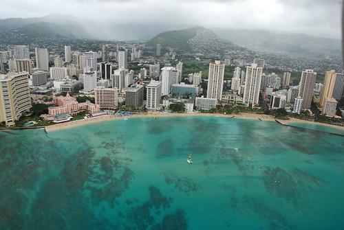 Waikiki Beach, Honolulu…Manoa Valley behind
Photo Credit: flikr.com
Our local winds were slightly lighter Tuesday, which will bounce back into the light to moderately strong range Wednesday. Weather maps show that a low pressure system to the northwest of Kauai, pushed our trade wind producing ridge of high pressure down closer to the islands. This in turn clocked our local winds around to the east-southeast locally. Winds from this direction put some parts of the state in a wind shadow behind the Big Island. As we get into Wednesday, the winds will likely turn back to the more customary easterly trade wind direction, and pick up a notch in strength. The trade winds will then continue through the rest of the week, strengthening further this weekend into next week.
There will be a few showers around, although nothing of particular note is expected. As the trade winds pick up some Wednesday, we’ll see the return of those normal passing showers along the windward coasts and slopes. The night and early morning hours will have the greatest likelihood of these few raindrops. The leeward sides will remain quite sunny and dry during the days, warm too. The Kona slopes on the Big Island, may see some late afternoon, or early evening showers falling locally.
It’s Tuesday evening as I begin updating this last paragraph of today’s narrative. As noted in the two paragraphs above, our weather here in the Hawaiian Islands will be just fine, really nice as a matter of fact! Our local beaches, at least most of them, basked in warm early spring sunshine Tuesday. I see no reason to believe that anything drastic will occur to change these positive weather conditions over the next couple of days, and for that matter…through the rest of this week. ~~~ Wednesday is a state holiday here in the islands, called Prince Kuhio Day. There’s a major parade that takes place in Honolulu, with marching bands, orchestras and color guards. It is celebrated to honor the birthday of Hawaii’s second delegate to Congress. Prince Kuhio was born in Koloa, Kauai, in 1871. As such, I have the day off from doing the tv weather show, and from regular day job in Kihei as well. ~~~ I’ll be back Wednesday morning nonetheless, with your next new weather narrative from paradise. I hope you have a great Tuesday night wherever you happen to be spending it! Aloha for now…Glenn.
Interesting: A vast ice shelf hanging on by a thin strip looks to be the next chunk to break off from the Antarctic Peninsula, the latest sign of global warming’s impact on Earth’s southernmost continent. Scientists are shocked by the rapid change of events. Glaciologist Ted Scambos of the University of Colorado was monitoring satellite images of the Wilkins Ice Shelf and spotted a huge iceberg measuring 25 miles by 1.5 miles (41 kilometers by 2.5 kilometers — about 10 times the area of Manhattan) that appeared to have broken away from the shelf. Scambos alerted colleagues at the British Antarctic Survey (BAS) that it looked like the entire ice shelf — about 6,180 square miles (16,000 square kilometers — about the size of Northern Ireland)— was at risk of collapsing. David Vaughan of the BAS had predicted in 1993 that the northern part of the Wilkins Ice Shelf was likely to be lost within 30 years if warming on the Peninsula continued at the same rate. "Wilkins is the largest ice shelf on the Antarctic Peninsula yet to be threatened," he said. "I didn’t expect to see things happen this quickly. The ice shelf is hanging by a thread — we’ll know in the next few days and weeks what its fate will be."
Interesting2: The National Oceanic and Atmospheric Administration (NOAA) has this week highlighted the potential for major flooding across parts of the United States this spring. Midwesterners have already had to contend with severe floods last week, and residents are being warned that this may be a precursor of things to come. With many central and eastern states having seen record snow falls this winter, the cumulative effect of a wet spring and rapid thaw is expected to bring a risk of flooding across a large swathe of the US. Areas most at risk include the Mississippi river basin, the Ohio river basin, the lower Missouri river basin and several states running from Colorado in the west to New York in the northeast. Floods are the most common natural disaster in the US and many residents will be worried, not unduly, with this spring also marking the 15th Anniversary of the Great Floods. The Great Floods of 1993 occurred across the Midwest along the Mississippi and Missouri rivers and their tributaries. The flood was among the most costly and devastating to ever occur in the US. The Federal Emergency Management Agency (FEMA) is urging everyone to be on a high alert and to make preparations to minimize any damage.
Interesting3: A new study predicts water circulation in Lake Tahoe is being dramatically altered by global warming, threatening the lake’s delicate ecosystem and famed clear waters. The University of California, Davis study said one likely consequence is warmer lake temperatures that will mean fewer cold-water native fish and more invasive species — like carp, large-mouth bass and bluegill. "What we expect is that deep mixing of Lake Tahoe’s water layers will become less frequent, even nonexistent, depleting the bottom waters of oxygen,” said Geoffrey Schladow, director of the Tahoe Environmental Research Center at U.S. Davis. Schladow, Associate Director John Reuter and postdoctoral researcher Goloka Sahoo presented the findings last week in Incline Village at a conference focusing on global warming and deep-water lakes. The changes, the study concluded, could turn Tahoe’s famed cobalt-blue waters to a murky green in about a decade. "A permanently stratified Lake Tahoe becomes just like any other lake or pond,” Schladow said. "It is no longer this unique, effervescent jewel, the finest example of nature’s grandeur.” On average, water in Lake Tahoe — at 1,644 feet deep — mixes every four years, the researchers said.
Posted by Glenn
No Comments
March 24-25 2008
Air Temperatures – The following maximum temperatures were recorded across the state of Hawaii Monday:
Lihue, Kauai – 81
Honolulu, Oahu – 86
Kaneohe, Oahu – 80
Kahului, Maui – 83
Hilo, Hawaii – 79
Kailua-Kona, Hawaii – 83
Temperatures ranged between these warmest and coolest spots near sea level at 4 p.m. Monday afternoon:
Kailua-kona – 84F
Hilo, Hawaii – 76
Precipitation Totals – The following numbers represent the largest precipitation totals (inches) during the last 24 hours on each of the major islands, as of Monday afternoon:
1.47 MOUNT WAIALEALE, KAUAI
0.46 NUUANU UPPER, OAHU
0.00 MOLOKAI
0.01 LANAI
0.00 KAHOOLAWE
0.23 WEST WAILUAIKI, MAUI
0.48 GLENWOOD, BIG ISLAND
Weather Chart – Here’s the latest (automatically updated) weather map. A 1027 millibar high pressure system is located far to the northeast of Hawaii Monday. Our local trade winds will remain light to moderately strong through Tuesday…still locally stronger and gusty in those windiest locations.
Satellite and Radar Images: To view the cloud conditions we have here in Hawaii, please use the following satellite links, starting off with the Infrared Satellite Image of the islands to see all the clouds around the state during the day and night. This next image is one that gives close images of the islands only during the daytime hours, and is referred to as a Close-up visible image. This next image shows a larger view of the Pacific…giving perspective to the wider ranging cloud patterns in the Pacific Ocean…out from the islands. To help you keep track of where any showers may be around the islands, here’s the latest animated radar image.
Hawaii’s Mountains – Here’s a link to the live webcam on the summit of near 14,000 foot Mauna Kea on the Big Island of Hawaii. The tallest peak on the island of Maui is the Haleakala Crater, which is near 10,000 feet in elevation. These two webcams are available during the daylight hours here in the islands…and when there’s a big moon rising just after sunset for an hour or two! Plus, during the nights and early mornings you will be able to see stars, and the sunrise too…depending upon cloud conditions.
Aloha Paragraphs
 Picture postcard perfect Hawaii
A favorably inclined spring trade wind weather pattern will prevail through the week. Weather maps show a trade wind producing high pressure system located far to the northeast of the Hawaiian Islands Monday evening…well offshore from the northern Baja California coast. This high pressure cell has an elongated ridge of high pressure extending from it, to a point north and northwest of Kauai. The location and strength of this high pressure area will keep light to moderately strong trade winds blowing across Hawaii. The computer models shows this fairly typical trade wind weather pattern remaining in place through at least the next week…probably longer.
The windward sides of the islands will see a few showers falling, while the leeward sides for the most part will remain dry. The trade winds will carry clouds in our direction from off the ocean. These clouds won’t be very productive however, in terms of dropping showers. The night and early morning hours will have the greatest likelihood of these few raindrops. The leeward sides will start the week with generally sunny skies during the days, although the Kona slopes on the Big Island, may see some late afternoon showers falling locally. A trough of low pressure aloft, to the west of Hawaii, may send us high and middle level clouds later in the week.
It’s Monday evening as I begin updating this last paragraph of today’s narrative. It appears that the islands will continue to see generally fine weather through the rest of this month. That fine weather, as noted in the paragraphs above, will include the presence of light to moderately strong trade winds, and those occasional passing showers along the windward sides. During the second half of the week, a stream of high and middle level cloudiness may arrive from the south and southwest…dimming and filtering our famous Hawaiian sunshine for a few days. These are the kinds of clouds that bring spectacular sunrise and sunset colors to our lovely islands! ~~~ By the way, I’ve received several emails lately, from folks wondering if the Humpback Whales were still in our local waters. Well, the answer it yes, they are still around, although it is getting to be towards the end of their long stay. They usually start arriving in October into November, and start the long journey back to Alaska later in March through April. You can see a couple of the responses we received, in relation to whales in Hawaiian waters below. ~~~ Monday was a great day here in the islands! The sun was warm, while the balmy trade wind breezes provided just the perfect amount of cooling relief from the early spring heat. I reckon that Tuesday will be a very similar day, with likely more nice weather traveling with us through the rest of this week. ~~~ I will be back again very early Tuesday morning with your next new weather narrative. I hope you have a great Monday night wherever you happen to be spending it! Aloha for now…Glenn.
Interesting: Cherry blossoms flowered in Tokyo and two other prefectures in Japan, the first of this season in designated observation areas across the country, according to the Japan Meteorological Agency. The emergence of the delicate, pale pink blooms is something of a national obsession, the focus of close media attention during the month or so it takes for the "cherry front" to move from south to north. The cherry blossoms, or Sakura in Japanese, opened in Tokyo and Shizuoka prefecture six days earlier than usual, while blossoms in southern Japan’s Kumamoto prefecture flowered two days earlier, according to the agency.
A Meteorological Agency official said recent warm days helped speed up the opening of those cherry blossoms. The announcement is made when five or six blossoms are observed on special "benchmark" trees in the city. In Tokyo, the benchmarks are several ancient trees in the grounds of Yasukuni Shrine, which is dedicated to the war dead. Families, friends and office workers crowd parks to eat and drink beer and sake as they admire the blossoms in often raucous "hanami" parties.
Interesting2: Fantasizing about building a bamboo home, but not sure if you’d like living in it? Here’s a place that you can try before you buy. Take a much needed vacation to a Maui resort (swim to the island if you must), and rent a bamboo jungalow to experience what it would be like to live in a bamboo home. Bamboo Living Technologies offers building code certified pre-fab homes in the USA, built for any climate. So, you can practically grow your own home.
Interesting3: Four days after a Kilauea volcano explosion sent debris over a 75-acre area, the possibility of future small explosions remained on the table while lava continued to flow into the ocean, the Hawaiian Volcano Observatory said yesterday in an online update. Sulfur dioxide emission rates at the summit remained at higher than background levels. On Friday the sulfur dioxide emission rate was about 1,200 metric tons a day compared with a background rate of 150-200 metric tons a day. The sulfur dioxide concentration in the air is likely to be hazardous downwind of the vents releasing the gas — in the southern caldera area, the HVO said. The National Park Service has closed Crater Rim Drive through the southern caldera area. Lava flows continued to hold the line on the eastern border. A public viewing area to see the lava flow is open between 2 and 10 p.m. with the last car in at 8 p.m.
Posted by Glenn
No Comments
March 23-24 2008
Air Temperatures – The following maximum temperatures were recorded across the state of Hawaii Sunday:
Lihue, Kauai – 82
Honolulu, Oahu – 84
Kaneohe, Oahu – 75
Kahului, Maui – 82
Hilo, Hawaii – 79
Kailua-Kona, Hawaii – 84
Temperatures ranged between these warmest and coolest spots near sea level at 4 p.m. Sunday afternoon:
Honolulu, Oahu – 82F
Hilo, Hawaii – 75
Precipitation Totals – The following numbers represent the largest precipitation totals (inches) during the last 24 hours on each of the major islands, as of Sunday afternoon:
2.09 MOUNT WAIALEALE, KAUAI
0.39 POAMOHO 2, OAHU
0.02 MOLOKAI
0.00 LANAI
0.00 KAHOOLAWE
0.79 PUU KUKUI, MAUI
0.67 GLENWOOD, BIG ISLAND
Weather Chart – Here’s the latest (automatically updated) weather map. A 1028 millibar high pressure system is located far to the northeast of Hawaii Monday. Our local trade winds will remain light to moderately strong through Tuesday…still locally stronger and gusty in those windiest locations.
Satellite and Radar Images: To view the cloud conditions we have here in Hawaii, please use the following satellite links, starting off with the Infrared Satellite Image of the islands to see all the clouds around the state during the day and night. This next image is one that gives close images of the islands only during the daytime hours, and is referred to as a Close-up visible image. This next image shows a larger view of the Pacific…giving perspective to the wider ranging cloud patterns in the Pacific Ocean…out from the islands. To help you keep track of where any showers may be around the islands, here’s the latest animated radar image.
Hawaii’s Mountains – Here’s a link to the live webcam on the summit of near 14,000 foot Mauna Kea on the Big Island of Hawaii. The tallest peak on the island of Maui is the Haleakala Crater, which is near 10,000 feet in elevation. These two webcams are available during the daylight hours here in the islands…and when there’s a big moon rising just after sunset for an hour or two! Plus, during the nights and early mornings you will be able to see stars, and the sunrise too…depending upon cloud conditions.
Aloha Paragraphs
 Happy Easter
The trade winds will stick around through the next week here in Hawaii. Our trade wind producing high pressure system remains firmly established in the eastern Pacific Ocean Sunday evening. It’s in a location favorable to generate moderately strong trade winds across our area. The winds remain light enough however, that the small craft advisory flags are not flying at the moment. We may see a little boost in wind speed during the middle of the new work week, and then again towards next weekend.
The windward sides, and around the mountains of Hawaii, will see just a few showers. A trough of low pressure remains in the area east of Hawaii, although is moving away steadily. An upper ridge is moving in to replace the upper trough, with modest rainfall amounts as we move into the new week. The daytime heating of the islands will cause afternoon clouds around the mountains, leading to some showers. The leeward sides will be remain dry for the most part…while a few showers will fall along the windward sides.
It’s Easter Sunday evening as I begin updating this last paragraph of today’s narrative. Looking into the new week ahead, it appears that a fairly typical trade wind weather pattern will prevail through the next seven days at least. This suggests lots of daytime sunshine along our beaches, with just the few showers falling here and there along the windward sides and around the mountains. There are no organized rainmakers, or cold fronts that are forecast to enter our area anytime soon. ~~~ I hung close to home today, actually didn’t leave other than a couple of walks. I just bbq’d a block of sashimi grade (able to eat raw) Ahi tuna, adding just a little salt and pepper, and a squeeze or two of fresh picked lemon. I’m sipping on a Sierra Nevada Pale Ale at the moment, my way of celebrating the Easter holiday. I’ll cook up in extra virgin olive oil, some onion, garlic, and a medium hot pepper, then add a can of organic Muir Glen tomatoes…when I go back down to the kitchen. I’ll add a few slices of uncured Canadian bacon for a little protein to this pasta sauce. When I cook pasta each night coming up, I’ll cover it with this sauce, then grade some nice Romano Pecorino cheese on it. I love being able to come home after a long work day, cook up a little pasta, and have the sauce already made! As I mentioned a couple of days ago, I will work Monday and Tuesday coming up, then have Wednesday off (local holiday), then work Thursday and Friday…before I’ll be enjoying yet another weekend. ~~~ I hope everyone had a good Easter, spending time with family or friends, perhaps sharing a great meal together. I wonder if anyone ate a little too much Easter candy, maybe one too many of those chocolate bunnies! At any rate, I’ll be back very early Monday morning with your next new weather narrative, be well until then. Aloha for now…Glenn.
This year is the earliest Easter any of us will ever see the rest of our lives! And only the most elderly of our population have ever seen it this early (95 years old or above). And none of us have ever, or will ever, see it a day earlier! Here’s the facts:
1) The next time Easter will be this early (March 23) will be the year 2228 (220 years from now). The last time it was this early was 1913 (so if you’re 95 or older, you are the only ones that were around for that!).
2) The next time it will be a day earlier, March 22, will be in the year 2285 (277 years from now). The last time it was on March 22 was 1818. So, no one alive today has or will ever see it any earlier than this year!
Posted by Glenn
No Comments
March 22-23 2008
Air Temperatures – The following maximum temperatures were recorded across the state of Hawaii Saturday:
Lihue, Kauai – 80
Honolulu, Oahu – 84
Kaneohe, Oahu – 78
Kahului, Maui – 81
Hilo, Hawaii – 82
Kailua-Kona, Hawaii – 83
Temperatures ranged between these warmest and coolest spots near sea level at 5 p.m. Saturday evening:
Kailua-kona – 81F
Hilo, Hawaii – 74
Precipitation Totals – The following numbers represent the largest precipitation totals (inches) during the last 24 hours on each of the major islands, as of Saturday afternoon:
2.24 MOUNT WAIALEALE, KAUAI
2.31 WAIANAE VALLEY, OAHU
0.07 MOLOKAI
0.00 LANAI
0.00 KAHOOLAWE
0.74 WEST WAILUAIKI, MAUI
1.11 MOUNTAIN VIEW, BIG ISLAND
Weather Chart – Here’s the latest (automatically updated) weather map. A high pressure system is located far to the northeast of Hawaii this weekend. Our local trade winds will remain light to moderately strong through Sunday…still locally a bit stronger and gusty in those windiest locales.
Satellite and Radar Images: To view the cloud conditions we have here in Hawaii, please use the following satellite links, starting off with the Infrared Satellite Image of the islands to see all the clouds around the state during the day and night. This next image is one that gives close images of the islands only during the daytime hours, and is referred to as a Close-up visible image. This next image shows a larger view of the Pacific…giving perspective to the wider ranging cloud patterns in the Pacific Ocean…out from the islands. To help you keep track of where any showers may be around the islands, here’s the latest animated radar image.
Hawaii’s Mountains – Here’s a link to the live webcam on the summit of near 14,000 foot Mauna Kea on the Big Island of Hawaii. The tallest peak on the island of Maui is the Haleakala Crater, which is near 10,000 feet in elevation. These two webcams are available during the daylight hours here in the islands…and when there’s a big moon rising just after sunset for an hour or two! Plus, during the nights and early mornings you will be able to see stars, and the sunrise too…depending upon cloud conditions.
Aloha Paragraphs
 Taking the drop on the north shore of Oahu
Photo Credit: Konaboy
The trade winds will be a part of our Hawaiian Island weather picture through the Easter holiday. Our trade wind producing high pressure system is now well entrenched in the eastern Pacific Ocean. It will be far enough away to provide moderately strong trade winds across our latitudes of the north central Pacific. The winds remain light enough though, that the small craft advisory flags are not flying at the moment. The latest computer forecast guidance suggests that the trade winds will continue to blow through the next week…remaining more or less in the moderately strong realms.
The windward sides, and around the mountains of Hawaii, will see the most active showers. A trough of low pressure remains in the area north and northeast of Hawaii, which will add some degree of enhancement to whatever local showers that fall. At the same time, the daytime heating of the islands will cause afternoon clouds around the mountains, leading to some showers, especially on the Kona slopes of the Big Island. The leeward sides will be remain dry for the most part, although they could see an upslope afternoon shower Easter afternoon.
It’s Saturday evening as I begin updating this last paragraph of today’s narrative. Our weather here in the islands is just fine on this Easter holiday weekend. The trade winds are blowing, as is often the case during the spring season. They aren’t blowing so fast that we have any wind advisories, but just fast enough to keep our local coconut palm trees leaning over pretty well in those most wind exposed areas. These trade winds are carrying some clouds our way, but nothing unusual about that. It looks to be a sunny Easter day on the leeward beaches, while the mountains will find rather thick clouds gathering again during the afternoon hours. All and all, there don’t seem to be any weather related problems at the moment. Looking into the future, this rather benign trade wind weather pattern will likely prevail through most of the new week ahead. ~~~ It’s Saturday evening here in Kula, Maui, which saw off and on cloudy periods during the afternoon hours. When the sun came poking out, it was warm as toast. The trade winds were reaching over here from the windward sides, adding a slight chill to the air in the shade. There were a couple of brief sprinkles, although looking over towards the windward side, over in Makawao and Haiku, it looks more showery. I think all the windward areas will find a few showers falling, which should stretch into the Easter holiday morning. Easter will be best, at least if you’re looking for a clear and dry morning, on the leeward sides of the islands. ~~~ I’m planning on staying home this evening, perhaps visiting with my neighbors some, listening to music, perhaps have a drink…with the fall back plan having me sitting on the couch reading. I wish there was a dance party to go to, which is always my favorite Saturday night activity, but alas, no such luck this weekend. I hope that you will be having fun Saturday night wherever you are spending it, and at the same time, here’s wishing you a most happy Easter day! Aloha for now…Glenn.
This year is the earliest Easter any of us will ever see the rest of our lives! And only the most elderly of our population have ever seen it this early (95 years old or above). And none of us have ever, or will ever, see it a day earlier! Here’s the facts:
1) The next time Easter will be this early (March 23) will be the year 2228 (220 years from now). The last time it was this early was 1913 (so if you’re 95 or older, you are the only ones that were around for that!).
2) The next time it will be a day earlier, March 22, will be in the year 2285 (277 years from now). The last time it was on March 22 was 1818. So, no one alive today has or will ever see it any earlier than this year!
Posted by Glenn
No Comments
March 21-22 2008
Air Temperatures – The following maximum temperatures were recorded across the state of Hawaii Friday:
Lihue, Kauai – 81
Honolulu, Oahu – 83
Kaneohe, Oahu – 79
Kahului, Maui – 83
Hilo, Hawaii – 77
Kailua-Kona, Hawaii – 82
Temperatures ranged between these warmest and coolest spots near sea level at 5 a.m. Friday morning:
Kailua-kona – 75F
Kahului, Maui – 65
Precipitation Totals – The following numbers represent the largest precipitation totals (inches) during the last 24 hours on each of the major islands, as of Friday morning:
9.66 MOUNT WAIALEALE, KAUAI
2.41 POAMOHO 2, OAHU
0.00 MOLOKAI
0.04 LANAI
0.00 KAHOOLAWE
0.79 PUU KUKUI, MAUI
1.07 GLENWOOD, BIG ISLAND
Weather Chart – Here’s the latest (automatically updated) weather map. A high pressure system is located far to the northeast of Hawaii this weekend. Our local trade winds have become lighter as the high pressure cell is now in the eastern Pacific Ocean…remaining light to moderately strong through Sunday.
Satellite and Radar Images: To view the cloud conditions we have here in Hawaii, please use the following satellite links, starting off with the Infrared Satellite Image of the islands to see all the clouds around the state during the day and night. This next image is one that gives close images of the islands only during the daytime hours, and is referred to as a Close-up visible image. This next image shows a larger view of the Pacific…giving perspective to the wider ranging cloud patterns in the Pacific Ocean…out from the islands. To help you keep track of where any showers may be around the islands, here’s the latest animated radar image.
Hawaii’s Mountains – Here’s a link to the live webcam on the summit of near 14,000 foot Mauna Kea on the Big Island of Hawaii. The tallest peak on the island of Maui is the Haleakala Crater, which is near 10,000 feet in elevation. These two webcams are available during the daylight hours here in the islands…and when there’s a big moon rising just after sunset for an hour or two! Plus, during the nights and early mornings you will be able to see stars, and the sunrise too…depending upon cloud conditions.
Aloha Paragraphs
 Whale watching from a kayak
Photo Credit: flikr.com
The trade winds will remain active, continuing that way through the weekend. Our trade wind producing high pressure system continues edging eastward. It has slipped into the eastern Pacific now, getting too far away to provide the strong and gusty trade winds that we saw earlier in the week. The winds are light enough now, that the small craft advisory flags have all been taken down…leaving no marine warnings or advisories in effect. The latest computer forecast guidance suggests that the trade winds will continue to blow through the next week…remaining more or less in the moderately strong realms.
The windward sides, and around the mountains of Hawaii, will see the most generous showers. A trough of low pressure is moving by to our north, which will add some degree of enhancement to whatever local showers that fall. The leeward sides will be remain dry for the most part, although even there could see a shower over the next couple of days. The wind
It’s Friday evening as I begin updating this last paragraph of today’s narrative. If we were to summarize the information in the two paragraphs above: somewhat lighter trade winds now, and passing showers along the windward sides and around the mountains. There’s nothing unusual about any of this, and is actually quite common, according to climatology…for the first several days of our new spring season. The one wild card at this point, is whether the trough of low pressure moving by to our north, will spark anymore heavy showers? What heavy showers you may ask? Well, how about the 9.66" that has fallen atop Mount Waialeale on Kauai during the last 24 hours! ~~~ Taking a look at this looping satellite image, we see that high and middle level clouds have thinned quite a bit Friday, and with any luck will stay away for the time being. I say "with any luck" in regards to the sun dimming and filtering that they do when they are around. ~~~ I’m meeting a friend in Paia for dinner, at a little vegetarian restaurant. The celebration is her 50th birthday, which is quite an occasion. ~~~ I will be early Saturday morning with your next new weather narrative from paradise. I hope you have a peaceful Good Friday night until then. Aloha for now…Glenn.
Interesting: Those incoming federal tax-rebate checks could do more than boost the economy. They might also boost your mood, with one caveat: You must spend the cash on others, not yourself. New research reveals that when individuals dole out money for gifts for friends or charitable donations, they get a boost in happiness while those who spend on themselves get no such cheery lift. Scientists have found evidence that income is linked with a person’s satisfaction with their life and other measures of happiness, but less is known about the link between how a person spends their money and happiness.
"We wanted to test our theory that how people spend their money is at least as important as how much money they earn," said Elizabeth Dunn, a psychologist at the University of British Columbia. The findings, to be detailed in the March 21 issue of the journal Science, come as no surprise to some marketing scientists. "It doesn’t surprise me at all that people find giving money away very rewarding," said Aaron Ahuvia, associate professor of marketing at the University of Michigan-Dearborn, who was not involved in the current study.
Interesting2: Whether you are cresting the peak of a majestic volcano or walking on a city street, there are immense amounts of heat beneath your feet — enough to provide all the energy the human population will ever need. In most places, though, that heat is trapped by solid rock — unavailable to our carbon-choked, energy-hungry populace. But the power could now be unleashed.
The 2009 Department of Energy (DOE) budget released in early February includes about $30 million for geothermal energy exploration — mostly for the construction of Enhanced Geothermal Systems (EGS) demonstration plants. This is the first step toward achieving enough clean, constant power from the earth to provide around 10 percent of our baseline energy needs — a goal put forward by a panel of experts in January 2007.
Interesting3: An explosion atop the long-erupting Kilauea volcano rained gravel-size rocks onto a tourist lookout, road and trail, injuring no one but forcing parts of a national park to close. It was the first explosion in Kilauea’s main Halemaumau Crater since 1924, scattering debris over about 75 acres, said Jim Kauahikaua, scientist-in-charge at Hawaiian Volcano Observatory on the Big Island. The 4,190-foot volcano has been erupting from fissures along its side steadily for more than a quarter-century. Hawaii Volcanoes National Park draws thousands of people daily, with a visitors center and lodge near the crater rim.
No lava erupted as part of the 3 a.m. explosion. That suggests it was caused by hydrothermal or gas buildup, Kauahikaua said. Scientists monitoring the summit say that there’s a "remote possibility" of an eruption inside the half-mile-wide crater, but that it’s unlikely because other indicators of an eruption aren’t present. "The recent explosive event represents a significant addition and change to Kilauea Volcano’s ongoing activity, and Hawaiian Volcano Observatory is using every means available to study its causes and consequences," Kauahikaua said in a statement.
Interesting4: For the first time, satellite imagery reveals thick Martian salt deposits scattered across the planet’s southern surface, which one planetary scientist claims could be sites of ancient life. The mats of sodium chloride — the same taste-enhancing mineral found on your kitchen table — serve as more evidence of Mars’ watery past, and researchers think the briney pools that made them could have been inhospitable to life. "If you’re trying to find life on Mars, the more and different places that exist, the better the chances are that one of them is going to have the right conditions," said Phil Christensen, a planetary geologist at Arizona State University. "It takes a lot of water to form salt, so this is another place to look." Christensen, who co-authored a March 21st study in the journal Science detailing the findings, said the salt deposits are a clear sign of water’s past presence, adding that they could be the most welcoming environment for life on Mars yet discovered.
Posted by Glenn
No Comments
March 20-21 2008
Air Temperatures – The following maximum temperatures were recorded across the state of Hawaii Thursday:
Lihue, Kauai – 80
Honolulu, Oahu – 83
Kaneohe, Oahu – 79
Kahului, Maui – 82
Hilo, Hawaii – 79
Kailua-Kona, Hawaii – 81
Temperatures ranged between these warmest and coolest spots near sea level at 4 a.m. Thursday morning:
Honolulu, Oahu – 72F
Kahului, Maui – 63
Precipitation Totals – The following numbers represent the largest precipitation totals (inches) during the last 24 hours on each of the major islands, as of Thursday afternoon:
2.14 MOUNT WAIALEALE, KAUAI
0.25 OAHU FOREST NWR, OAHU
0.00 MOLOKAI
0.00 LANAI
0.00 KAHOOLAWE
0.50 WEST WAILUAIKI, MAUI
0.65 GLENWOOD, BIG ISLAND
Weather Chart – Here’s the latest (automatically updated) weather map. A high pressure system is located to the northeast of Hawaii. Our local trade winds will get lighter as it moves swiftly eastward into the eastern Pacific Ocean…becoming light to moderately strong.
Satellite and Radar Images: To view the cloud conditions we have here in Hawaii, please use the following satellite links, starting off with the Infrared Satellite Image of the islands to see all the clouds around the state during the day and night. This next image is one that gives close images of the islands only during the daytime hours, and is referred to as a Close-up visible image. This next image shows a larger view of the Pacific…giving perspective to the wider ranging cloud patterns in the Pacific Ocean…out from the islands. To help you keep track of where any showers may be around the islands, here’s the latest animated radar image.
Hawaii’s Mountains – Here’s a link to the live webcam on the summit of near 14,000 foot Mauna Kea on the Big Island of Hawaii. The tallest peak on the island of Maui is the Haleakala Crater, which is near 10,000 feet in elevation. These two webcams are available during the daylight hours here in the islands…and when there’s a big moon rising just after sunset for an hour or two! Plus, during the nights and early mornings you will be able to see stars, and the sunrise too…depending upon cloud conditions.
Aloha Paragraphs
 Looking down into the Haleakala Crater on Maui
Photo Credit: flikr.com
The strong and gusty trade winds of the last few days, will get lighter now into the weekend. A large high pressure center located to the northeast of Hawaii, has been the source area of our blustery trade wind flow this week. This high pressure cell is moving swiftly eastward, prompting the lighter winds. Small craft wind advisory flags have been scaled back considerably now, covering only those few windiest spots around the Big Island. The latest computer forecast guidance suggests that the trade winds will continue to blow through the next week.
Showery clouds have been hit and miss along the windward sides lately, although may become a bit more generous and frequent Friday. A trough of low pressure overhead, will likely enhance the incoming showers to some extent, carried by the trade winds into the weekend. This enhancement may stay in place into the early part of next week. The leeward sides will be generally immune from these showers, except on the smaller islands…where a few showers may be carried over there on the trade winds. The Kona slopes can always find a few afternoon showers falling of course.
It’s Thursday evening as I begin updating this last paragraph of today’s narrative. The spring equinox occurred early Thursday morning, bringing us into the first day of our spring season. Our local weather is acting just about right, at least looking at it from a climatological perspective. This of course is because the trade winds are the dominant weather element in our Hawaiian Island weather picture…which is a common springtime phenomenon. There don’t seem to be any major changes coming up through the rest of the week, and for that matter, nothing untoward weatherwise into early next week. The windward showers will increase some, with off and on showers expected there Friday into the weekend. ~~~ A quick glance at this satellite imagery, shows that high clouds continue to stream in our direction, thanks to the jet stream level winds aloft. A trough of low pressure, which is manufacturing all the cloudiness to our west, is still active. This suggests that we will see more of those sky beautifying high cirrus clouds arriving over the next few days…providing great sunset and sunrise colors! ~~~ Thursday was another good day here in the islands, the trade winds calmed down some, there were a few windward showers here and there, and those pesky high clouds arrived high in the atmosphere once again. I’m about ready to leave Kihei, heading into Kahului for a little shopping. I need some new walking shoes, so will try to find a comfortable pair first, and then consider how nice they may look as a secondary consideration. I can’t wait to start my three day holiday weekend, I’m so excited! I’ll catch up with you again early Friday morning, I hope everyone has a great Thursday night until then! Aloha for now…Glenn.
Interesting: Those incoming federal tax-rebate checks could do more than boost the economy. They might also boost your mood, with one caveat: You must spend the cash on others, not yourself. New research reveals that when individuals dole out money for gifts for friends or charitable donations, they get a boost in happiness while those who spend on themselves get no such cheery lift. Scientists have found evidence that income is linked with a person’s satisfaction with their life and other measures of happiness, but less is known about the link between how a person spends their money and happiness.
"We wanted to test our theory that how people spend their money is at least as important as how much money they earn," said Elizabeth Dunn, a psychologist at the University of British Columbia. The findings, to be detailed in the March 21 issue of the journal Science, come as no surprise to some marketing scientists. "It doesn’t surprise me at all that people find giving money away very rewarding," said Aaron Ahuvia, associate professor of marketing at the University of Michigan-Dearborn, who was not involved in the current study.
Interesting2: Whether you are cresting the peak of a majestic volcano or walking on a city street, there are immense amounts of heat beneath your feet — enough to provide all the energy the human population will ever need. In most places, though, that heat is trapped by solid rock — unavailable to our carbon-choked, energy-hungry populace. But the power could now be unleashed.
The 2009 Department of Energy (DOE) budget released in early February includes about $30 million for geothermal energy exploration — mostly for the construction of Enhanced Geothermal Systems (EGS) demonstration plants. This is the first step toward achieving enough clean, constant power from the earth to provide around 10 percent of our baseline energy needs — a goal put forward by a panel of experts in January 2007.
Interesting3: An explosion atop the long-erupting Kilauea volcano rained gravel-size rocks onto a tourist lookout, road and trail, injuring no one but forcing parts of a national park to close. It was the first explosion in Kilauea’s main Halemaumau Crater since 1924, scattering debris over about 75 acres, said Jim Kauahikaua, scientist-in-charge at Hawaiian Volcano Observatory on the Big Island. The 4,190-foot volcano has been erupting from fissures along its side steadily for more than a quarter-century. Hawaii Volcanoes National Park draws thousands of people daily, with a visitors center and lodge near the crater rim.
No lava erupted as part of the 3 a.m. explosion. That suggests it was caused by hydrothermal or gas buildup, Kauahikaua said. Scientists monitoring the summit say that there’s a "remote possibility" of an eruption inside the half-mile-wide crater, but that it’s unlikely because other indicators of an eruption aren’t present. "The recent explosive event represents a significant addition and change to Kilauea Volcano’s ongoing activity, and Hawaiian Volcano Observatory is using every means available to study its causes and consequences," Kauahikaua said in a statement.
Interesting4: For the first time, satellite imagery reveals thick Martian salt deposits scattered across the planet’s southern surface, which one planetary scientist claims could be sites of ancient life. The mats of sodium chloride — the same taste-enhancing mineral found on your kitchen table — serve as more evidence of Mars’ watery past, and researchers think the briney pools that made them could have beehospitable to life. "If you’re trying to find life on Mars, the more and different places that exist, the better the chances are that one of them is going to have the right conditions," said Phil Christensen, a planetary geologist at Arizona State University. "It takes a lot of water to form salt, so this is another place to look." Christensen, who co-authored a March 21st study in the journal Science detailing the findings, said the salt deposits are a clear sign of water’s past presence, adding that they could be the most welcoming environment for life on Mars yet discovered.
Posted by Glenn
No Comments
March 19-20 2008
Air Temperatures – The following maximum temperatures were recorded across the state of Hawaii Wednesday:
Lihue, Kauai – 79
Honolulu, Oahu – 84
Kaneohe, Oahu – 78
Kahului, Maui – 81
Hilo, Hawaii – 76
Kailua-Kona, Hawaii – 82
Temperatures ranged between these warmest and coolest spots near sea level at 4 a.m. Wednesday morning:
Honolulu, Oahu – 74F
Hilo, Hawaii – 67
Precipitation Totals – The following numbers represent the largest precipitation totals (inches) during the last 24 hours on each of the major islands, as of Wednesday afternoon:
2.92 MOUNT WAIALEALE, KAUAI
1.89 OAHU FOREST NWR, OAHU
0.01 MOLOKAI
0.01 LANAI
0.00 KAHOOLAWE
0.94 WEST WAILUAIKI, MAUI
0.89 GLENWOOD, BIG ISLAND
Weather Chart – Here’s the latest (automatically updated) weather map. A 1037 millibar high pressure system is located far to the north of Hawaii Thursday. It will keep moderate to fresh trade winds blowing, although as it moves swiftly eastward…our local trade winds will fall off some in strength into Friday.
Satellite and Radar Images: To view the cloud conditions we have here in Hawaii, please use the following satellite links, starting off with the Infrared Satellite Image of the islands to see all the clouds around the state during the day and night. This next image is one that gives close images of the islands only during the daytime hours, and is referred to as a Close-up visible image. This next image shows a larger view of the Pacific…giving perspective to the wider ranging cloud patterns in the Pacific Ocean…out from the islands. To help you keep track of where any showers may be around the islands, here’s the latest animated radar image.
Hawaii’s Mountains – Here’s a link to the live webcam on the summit of near 14,000 foot Mauna Kea on the Big Island of Hawaii. The tallest peak on the island of Maui is the Haleakala Crater, which is near 10,000 feet in elevation. These two webcams are available during the daylight hours here in the islands…and when there’s a big moon rising just after sunset for an hour or two! Plus, during the nights and early mornings you will be able to see stars, and the sunrise too…depending upon cloud conditions.
Aloha Paragraphs
 Dolphins playing in the ocean offshore from Oahu
Photo Credit: flikr.com
Locally strong and gusty trade winds will continue into Thursday…then gradually mellow out a little Friday into the weekend. A large high pressure center located far to the north of Hawaii, is the source areas of our blustery trade wind flow Wednesday night. Small craft wind advisory flags cover all of Hawaii’s coastal waters, in addition to all the major channels in Hawaii. Those areas protected from the direct trade winds, will have lighter winds as usual. The latest computer forecast guidance suggests that the trade winds will continue to blow right on into next week.
The windward sides of the islands will see occasional passing showers. The trade winds are strong enough now that a few stray showers may find their way over into a few leeward areas. It appears that we have slipped back into a fairly normal trade wind weather pattern, at least in terms of precipitation coverage and intensity. The Kona slopes may see a few afternoon showers, which is common when the trades are blowing. Trade wind showers may increase some this weekend along the windward sides.
It’s Wednesday evening as I begin updating this last paragraph of today’s narrative. Winter is just about over, with the spring equinox officially starting at 1:48 a.m. early Thursday morning. This made Wednesday the last full day of winter! Wednesday was more like a spring day than a winter day however, what with all the gusty trade winds blowing across our tropical latitudes of the north central Pacific Ocean. ~~~ A quick glance at this satellite imagery, shows that there’s a considerable amount of high level cirrus clouds coming our way from the west and northwest. They sure do make for great sunrise and sunsets colors when their around…which will be the case over the next few days. ~~~ So then, when you go to bed tonight, it will still be winter, although by the time you get up Thursday morning, bingo, it will be the first day of spring 2008! ~~~ I’ll be back with your next new weather narrative very early Thursday morning, I hope you have a restful Wednesday night until then! Aloha for now…Glenn.
Interesting: After the coldest start to a year in more than a decade, spring will bring relief to the northern hemisphere from Thursday. Bucking the trend of global warming, the start of 2008 saw icy weather around the world from China to Greece. But despite its chilly start, 2008 is expected to end up among the top 10 warmest years since records began in the 1860s. This winter, ski resorts from the United States to Scandinavia have deep snow. Last year, after a string of mild winters, some feared climate change might put them out of business. In many countries crops and plants are back on a more "normal" schedule. Cherry trees in Washington are on target to blossom during a March 29-April 13 festival that has sometimes mistimed the peak blooms.
"So far 2008, for the globe, has been quite cold, only just above the 1961-90 average," said Phil Jones, head of the Climatic Research Unit at the University of East Anglia which supplies global temperature data to the United Nations. "This is just January and February, so two coolish months comparable to what happened in 1994 and 1996," he told Reuters. The northern spring formally begins on March 20 this year. And an underlying warming trend, blamed by the U.N. Climate Panel on human use of fossil fuels, is likely to reassert itself after the end of a La Nina cooling of the Pacific in the coming months. There were similar conditions in 1998 and 2005, the hottest so far, Jones said.
Interesting2: Scientists know that air pollution particles from mid-latitude cities migrate to the Arctic and form an ugly haze, but a new University of Utah study finds surprising evidence that polar explorers saw the same phenomenon as early as 1870. “The reaction from some colleagues — when we first mentioned that people had seen haze in the late 1800s — was that it was crazy,” says Tim Garrett, assistant professor of meteorology and senior author of the study. “Who would have thought the Arctic could be so polluted back then? Our instinctive reaction is to believe the world was a cleaner place 130 years ago.” The study will be published soon in the March 2008 issue of the Bulletin of the American Meteorological Society. By searching through historic records written by early Arctic explorers, Garrett and his collaborator Lisa Verzella, former undergraduate student at the University of Utah, were able to find evidence of an aerosol “dry haze” that settled onto the ice to form a layer of grayish dust containing metallic particles. The haze and dust were likely the byproducts of smelting and coal combustion generated during the Industrial Revolution.
Interesting3: Only up to powering light bulbs so far, "salt power" is a tantalizing if distant prospect as high oil prices make alternative energy sources look more economical. Two tiny projects to mix sea and river water — one by the fjord south of Oslo, the other at a Dutch seaside lake — are due on stream this year and may point to a new source of clean energy in estuaries from the Mississippi to the Yangtze. The experiments, which seek to capture the energy released when fresh and salt water are mixed, build on knowledge that has been around for centuries — in one case imitating the process of osmosis used by trees to suck water from their roots. Although they are far from being economically viable, if eventually successful they might help a long-term quest to diversify away from fossil fuels such as coal and oil, widely blamed for stoking global warming. "We might well be able to find new promising solutions such as generating power naturally from osmotic forces occurring when salt and fresh water are mixing," Norwegian deputy Energy Minister Liv Monica Stubholt said in a speech earlier this month. And rivers flow around the clock, an advantage compared to variable wind or solar power.
Interesting4: Birds start singing in the spring because of a biological response to longer days, researchers said on Wednesday. When birds are exposed to light for longer periods, certain brain cells trigger a series of hormonal reactions telling them to find a mating partner, which they do by singing, a team of Japanese and British researchers reported in the journal Nature. "While we knew what area of the brain was affected by seasonal change, until now we did not know the exact mechanism involved," said Peter Sharp, a researcher at the Roslin Institute near Edinburgh, who worked on the study.
The researchers, led by Takashi Yoshimura of the Nagoya University in Japan, scanned 38,000 genes present in brain samples taken from Japanese quails to see which of the birds’ genes were affected by varying degrees of light. Genes in cells on the surface of the brain switched on when the birds received more light and began releasing a thyroid-stimulating hormone. The genes activated 14 hours after dawn on the first day of sufficient length, the researchers said.
« Previous Page — Next Page »


