2008
Yearly Archive
Posted by Glenn
No Comments
May 7-8 2008
Air Temperatures – The following maximum temperatures were recorded across the state of Hawaii Wednesday:
Lihue, Kauai – 81
Honolulu, Oahu – 85
Kaneohe, Oahu – 80
Kahului, Maui – 85
Hilo, Hawaii – 80
Kailua-Kona, Hawaii – 82
Air Temperatures ranged between these warmest and coolest spots near sea level at 4 p.m. Wednesday afternoon:
Honolulu, Oahu – 83F
Hilo, Hawaii – 77
Precipitation Totals – The following numbers represent the largest precipitation totals (inches) during the last 24 hours on each of the major islands, as of Wednesday afternoon:
0.80 MOUNT WAIALEALE, KAUAI
0.35 POAMOHO 2, OAHU
0.06 MOLOKAI
0.01 LANAI
0.00 KAHOOLAWE
0.45 PUU KUKUI, MAUI
0.49 PAHOA, BIG ISLAND
Weather Chart – Here’s the latest (automatically updated) weather map showing a large 1031 milliar high pressure center far to the NE of the state. This high pressure system will keep moderately strong to fresh trade winds blowing across our islands Thursday and Friday…locally strong and gusty.
Satellite and Radar Images: To view the cloud conditions we have here in Hawaii, please use the following satellite links, starting off with the Infrared Satellite Image of the islands to see all the clouds around the state during the day and night. This next image is one that gives close images of the islands only during the daytime hours, and is referred to as a Close-up visible image. This next image shows a larger view of the Pacific…giving perspective to the wider ranging cloud patterns in the Pacific Ocean…out from the islands. To help you keep track of where any showers may be around the islands, here’s the latest animated radar image.
Hawaii’s Mountains – Here’s a link to the live webcam on the summit of near 14,000 foot Mauna Kea on the Big Island of Hawaii. The tallest peak on the island of Maui is the Haleakala Crater, which is near 10,000 feet in elevation. These two webcams are available during the daylight hours here in the islands…and when there’s a big moon rising just after sunset for an hour or two! Plus, during the nights and early mornings you will be able to see stars, and the sunrise too…depending upon cloud conditions.
Aloha Paragraphs
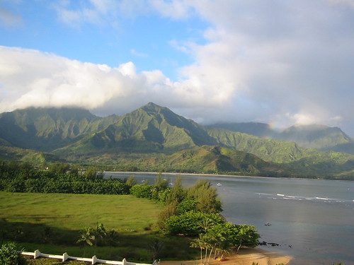 Princeville, Kauai
The trade winds have picked up in strength now, becoming rather blustery in some places. We’ll see the trade winds increase another notch Thursday through the rest of the week. A small craft wind advisory is now active in Hawaii’s coastal and channel waters around Maui and the Big Island, which may be expanded a bit further up the chain into the weekend. These trade will blow through next Tuesday, at which point they will likely slow down, and perhaps become southeast…remaining light for several days thereafter.
Despite the stronger trade winds, we won’t see much of an increase in showers. The windward areas as usual will find the most generous rainfall. The leeward beaches will be generally quite dry, although a few showers could fall along the Kona slopes of the Big Island during the afternoon or early evening hours. It appears that there will be little change in this favorably inclined trade wind weather pattern this week. We may see some changes occurring around the middle of next week.
It’s Wednesday evening as I begin writing this last section of today’s narrative. In the last sentence in the paragraph above, I intimated that there may be some changes starting around next Wednesday. The computer models want to have our winds getting much lighter then, and turn to the southeast. It’s still too early to totally accept this future possibility. If on the other hand, it were to occur as the models are pointing out, we would see the return of potentially thick vog, along with an increase in afternoon convective cloudiness and showers for a few days then.
~~~ It’s always risky to talk about what will be happening a week out into the future. The accuracy of weather forecasts is usually pretty good for that day, or perhaps even a day or two ahead. When you try and project out seven days however, well, that can bring weathermen and women, back to the drawing boards several times…back to their chalk boards, doing some pretty heavy erasing! So, we’ll hold this prospect lightly for the time being, and just keep a wary eye on it through the rest of this week. The models have even gone so far as to suggest an active cold front moving down through the state, which would be unusual this time of year. Stranger things have happened, but if we use climatology as a measuring stick, it would be unlikely to see a frontal cloud band moving down through the island chain during the middle of May.
~~~ Wednesday the weather followed the forecast script pretty well, staying nice for almost all outdoor activities. At the moment, as demonstrated with this looping satellite image, we’re mostly clear of the persistent high cirrus cloudiness of late. There are a few wisps moving by, with a couple of potential new areas moving our way on the upper winds aloft. The trade winds were the most notable weather element today, pushing our tropical vegetation around, and chalking-up our coastal waters with lots of white caps. Speaking of the ocean, without very much surf breaking on our local beaches now, this is an excellent time to be snorkeling, swimming, and just generally being in the ocean…although watch out for the gusty winds if you’re out in kayaks.
~~~ I will be back very early Thursday morning with your next new Hawaiian Island weather narrative. I hope you have a great Wednesday night, whether you’re here in the Islands, or in Seattle, Portland, San Francisco, LA or San Diego…or elsewhere of course! Aloha for now…Glenn
Note: I have not mentioned the devastating cyclone, named Nargis, which slammed into the river delta region in Myanmar (Burma). I was tracking the storm a week before it made landfall, as part of my duties at the Pacific Disaster Center here in Kihei, Maui, where I’m the senior weather analyst. So I have been very aware of the horrendous after-effects of this major storm…up to 100,000 deaths expected! There is certainly no lack of news, from various sources, which is the reason that I’m not including information about it on this website. I send my very best wishes to everyone involved in that area! Glenn
Interesting: China’s Huge Self-Sustaining Soar LED Wall, alled the GreenPix Zero Energy Media Wall, and with 2,292 individual color LEDs, comparable to a 24,000 sq. ft. monitor screen, it’s said to be the largest color LED display in the world. The wall is solar-powered too — photovoltaics are integrated into the wall’s glass curtain, and it harvests power during the day, to illuminate the display at night. Designed by, Simone Giostra & Partners Architects, the GreenPix wall is part of the Xicui Entertainment Complex in Beijing, near the site of the 2008 Olympics. The polycrystalline photovoltaic cells are laminated within the glass of the curtain wall and placed with changing density on the entire building’s skin. The density pattern increases building’s performance, allowing natural light when required by interior program, while reducing heat gain and transforming excessive solar radiation into energy for the media wall. The building will open to the public in June 2008, with a specially commissioned program of video installations and live performances by artists.
Interesting2: Scientists have suggested that due to the adverse effects of Arctic ice melting, the hybrid of a polar bear and grizzly bear – dubbed the ‘grolar bear’, might rise in numbers. According to a report in The Sun , the effects of climate change means that the hybrid bears could become more common as their habitats increasingly overlap due to global warming. "One of the real things that is happening is that grizzlies are moving north, at the same time the polar bears are forced to be on the beach and we have found a number of grizzly bear polar bear hybrids," said biologist Dr George Divoky, who has worked in the Arctic region for over three decades. "Essentially that could mean that it would save the polar bear genes in the grizzly population," he added. Biologists have already spotted the hybrid species.
Interesting3: Polar bears may have it relatively easy. It’s the tropical creatures that could really struggle if the climate warms even a few degrees in places that are already hot, scientists reported on Monday. That doesn’t mean polar bears and other wildlife in the polar regions won’t feel the impact of climate change. They probably will, because that is where the warming is expected to be most extreme, as much as 18 degrees F (10 degrees C) by the end of this century. But there are far fewer species living in the Arctic and Antarctic and in the temperate zones than in the tropics, said Curtis Deutsch of the University of California at Los Angeles. Many of these tropical creatures are living at the edge of their temperature tolerance already. Even the slight tropical warming predicted by 2100 — 5.4 degrees F (3 degrees C) — could push them to the brink, Deutsch said in a telephone interview. In research published in Proceedings of the National Academy of Sciences, Deutsch and his co-authors investigated what could happen to cold-blooded animals in the tropics over the next 100 years if the predictions of greenhouse warming hold true. They chose cold-blooded creatures — mostly insects but also frogs, lizards and turtles — because warm-blooded animals have other ways of regulating their body temperatures, such as growing a thick coat of fur to guard against cold and shedding when it gets warm.
Interesting4: Climate change is harder on women in poor countries, where mothers stay in areas hit by drought, deforestation or crop failure as men move to literally greener pastures, a Nobel Peace laureate said on Tuesday. "Many destructive activities against the environment disproportionately affect women, because most women in the world, and especially in the developing world, are very dependent on primary natural resources: land, forests, waters," said Wangari Maathai of Kenya. "Women are very immediately affected, and usually women and children can’t run away," said Maathai, who won the 2004 Nobel Peace Prize for her work on sustainable development. "Men can trek and go looking for greener pastures in other areas in other countries … but for women, they’re usually left on site to face the consequences," she said. "So when there is deforestation, when there is drought, when there is crop failure, it is the women and children who are the most adversely affected." Maathai was in Washington with 1997 Nobel Peace laureate Jody Williams, who got the award for her work in creating an international treaty to ban landmines, and both spoke to reporters at a briefing. Williams said she saw climate change as a threat to security, and said desertification of former agricultural land fueled the conflict in Darfur.
Posted by Glenn
No Comments
May 6-7 2008
Air Temperatures – The following maximum temperatures were recorded across the state of Hawaii Tuesday:
Lihue, Kauai – 81
Honolulu, Oahu – 85
Kaneohe, Oahu – 81
Kahului, Maui – 85
Hilo, Hawaii – 80
Kailua-Kona, Hawaii – 82
Air Temperatures ranged between these warmest and coolest spots near sea level at 4 p.m. Tuesday afternoon:
Honolulu, Oahu – 84F
Lihue, Kauai – 77
Precipitation Totals – The following numbers represent the largest precipitation totals (inches) during the last 24 hours on each of the major islands, as of Tuesday afternoon:
1.92 MOUNT WAIALEALE, KAUAI
0.21 NUUANU UPPER, OAHU
0.00 MOLOKAI
0.00 LANAI
0.00 KAHOOLAWE
0.27 PUU KUKUI, MAUI
0.62 HONAUNAU, BIG ISLAND
Weather Chart – Here’s the latest (automatically updated) weather map showing a 1030 milliar high pressure center far to the NE of the state. This high pressure system will keep light to moderately strong trade winds blowing across our islands Wednesday, increasing some Thursday.
Satellite and Radar Images: To view the cloud conditions we have here in Hawaii, please use the following satellite links, starting off with the Infrared Satellite Image of the islands to see all the clouds around the state during the day and night. This next image is one that gives close images of the islands only during the daytime hours, and is referred to as a Close-up visible image. This next image shows a larger view of the Pacific…giving perspective to the wider ranging cloud patterns in the Pacific Ocean…out from the islands. To help you keep track of where any showers may be around the islands, here’s the latest animated radar image.
Hawaii’s Mountains – Here’s a link to the live webcam on the summit of near 14,000 foot Mauna Kea on the Big Island of Hawaii. The tallest peak on the island of Maui is the Haleakala Crater, which is near 10,000 feet in elevation. These two webcams are available during the daylight hours here in the islands…and when there’s a big moon rising just after sunset for an hour or two! Plus, during the nights and early mornings you will be able to see stars, and the sunrise too…depending upon cloud conditions.
Aloha Paragraphs
 The Kona coast on the Big Island
The typical springtime trade winds will continue to blow over the Hawaiian Islands. We’ll see light to moderately strong trade winds blowing into Wednesday. The computer forecast models show that the trade winds will increase a notch or two Thursday through the rest of the week. There are no small craft wind advisories active in Hawaii’s coastal or channel waters at the moment, but will likely be needed during the second half of the week. These persistent trade winds will continue on into next week, providing fair weather.
These trade winds will carry a few showers our way, depositing them most generously along the windward sides of the islands. The overlying atmosphere remains just a little shower prone, so that there won’t be any unusual rainfall activity. The leeward beaches will be generally quite dry, although a few showers could fall locally. It appears that there will be little change in this more or less normal trade wind weather pattern this week, although we could use more showers as we head towards our dry summer season.
It’s Tuesday evening as I begin writing this last section of today’s narrative. As noted above, there’s nothing unusual happening here in the Hawaiian Islands at the moment. As this looping satellite image shows, the latest stream of high clouds to the west and southwest of the state, have now dropped south over or near the Big Island. There’s another batch of high clouds associated with a trough of low pressure to the west of Kauai this evening. Some of this seems to be sweeping over the Kauai end of the island chain, which may spread over the central islands during the night.
~~~ Tuesday was a great day, with abundant sunshine beaming down in most areas. There were some cloud buildups over and around the mountains, although that is very common during such a trade wind weather pattern…as we have going on now. As the air cools during the night, we’re apt to see a modest increase in showers along the windward sides, which again is very typical. Skies should be mostly clear to partly cloudy for the most part Wednesday, with little indication of any significant changes taking place through the rest of this week, into the first several days of next week.
~~~ The computer models want to have our winds getting much lighter, and turn to the southeast around next Wednesday. It’s still too early in the game to cement this prospect into place. If on the other hand, it were to occur as the models are hinting, we would see the return of potentially thick vog, along with an increase in afternoon convective cloudiness…in addition to generous shower activity in the interior parts of the islands. I believe we should take a wait and see posture at this point, and just keep an eye on what develops in this regard later this week.
~~~ I hope you have a great Tuesday night wherever you are spending it! I’ll be back very early Wednesday morning with your next new weather narrative from paradise. Aloha for now…Glenn.
Interesting: For eight years, Tony and Sam Bayaoa have grown thousands of bright red, yellow and pink protea flowers on their farm. Then in March, Kilauea volcano opened a new vent and began spewing double the usual amount of toxic gas. Now about 70 percent of their crop is dried, brown and brittle. "The first reaction was — did someone poison the plants?" said Tony Bayaoa, whose two-acre farm is 35 miles from the volcano. "I’ve lost my livelihood." Big Island crops are shriveling, as sulfur dioxide from Kilauea wafts over them and envelops them in "vog," or volcanic smog. People are wheezing, and schoolchildren are being kept indoors during recess. High gas levels led Hawaii Volcanoes National Park to close several days last month, forcing the evacuation of thousands of visitors. Residents of this volcanic island are used to toxic gas. But this haze is so bad that farmers are thinking about growing different crops, and many people are worrying about their health. Kirk Brewer, 33, an electrician who moved to the Big Island in 2006 from Southern California, blames his headaches and wife Tracy‘s itchy skin, sore throat and runny nose on the vog. "It’s a bummer when you go to the other islands and see how clear and blue it is, but we’ll just deal with it," Brewer said. When educator Ann Peterson of Kona went to the bank last week, she and the teller were making the same noises in their throats. They looked at each other and said in unison, "Vog!" Kilauea on the BigIsland has been erupting continuously since 1983. But in mid-March, a new vent formed at the summit, giving Kilauea two large sulfur dioxide outlets instead of one.
Interesting2: Using sophisticated unmanned aircraft, research scientists at Scripps Institution of Oceanography, UC San Diego hope to assess Southern California’s potential for climate change and better understand the sources of air pollution. Funded by the California Energy Commission, the California AUAV Air Pollution Profiling Study (CAPPS) uses autonomous unmanned aerial vehicles (AUAVs) to gather meteorological data as the aircraft fly through clouds and aerosol masses in Southern California skies. The flights will take place at Edwards Air Force Base near Rosamond, Calif. The study began its first sortie of data-gathering flights in April 2008. Scripps Atmospheric and Climate Sciences Professor V. Ramanathan, CAPPS’s lead scientist, said the characteristics of Southern California climate and meteorology – ranging from its dry weather to its tendency to trap rather than export smog – could make it especially prone to climate change consequences of air pollution such as accelerated snowmelt and dimming at ground level.
Interesting3: There’s a downside to nearly all renewable energy technologies available for homeowners. Cost. Though over time a solar power or small wind system may pay for itself in savings from not buying fuels or power from the grid, the initial outlay for renewable energy is staggering for mere mortals. Despite the wisdom of a penny saved is a penny earned, most Americans consider sales price first, long term savings last. However simple, low tech, clever products or affordable high tech plug and play technologies may be the key to bringing renewable energy into the home. For example a water-filled black rubber, plastic or even canvas bag hung from a tree limb is a way for campers to grab a hot shower courtesy of the heat of the Sun. Like the hot water that flows from a garden hose lying on the ground on a sunny day, given a few hours a sack of water hanging in the sunlight will provide a soothing, though brief, shower. These solar water heaters are plentiful through camping and outdoor supply outlets. (The technology has advanced, too, with some models offering battery-powered pumps so the solar heated water can be used for more than showers.)
Interesting4: Scientists at the University of Konstanz in Germany and the National Institute of Standards and Technology (NIST) have demonstrated an ultrafast laser that offers a record combination of high speed, short pulses and high average power. The same NIST group also has shown that this type of laser, when used as a frequency comb—an ultraprecise technique for measuring different colors of light—could boost the sensitivity of astronomical tools searching for other Earthlike planets as much as 100 fold. The dime-sized laser, to be described Thursday, May 8, at the Conference on Lasers and Electro-Optics,* emits 10 billion pulses per second, each lasting about 40 femtoseconds (quadrillionths of a second), with an average power of 650 milliwatts. For comparison, the new laser produces pulses 10 times more often than a standard NIST frequency comb while producing much shorter pulses than other lasers operating at comparable speeds. The new laser is also 100 to 1000 times more powerful than typical high-speed lasers, producing clearer signals in experiments. The laser was built by Albrecht Bartels at the Center for Applied Photonics of the University of Konstanz.
Interesting5: Polar bears may have it relatively easy. It’s the tropical creatures that could really struggle if the climate warms even a few degrees in places that are already hot, scientists reported on Monday. That doesn’t mean polar bears and other wildlife in the polar regions won’t feel the impact of climate change. They probably will, because that is where the warming is expected to be most extreme, as much as 18 degrees F (10 degrees C) by the end of this century. But there are far fewer species living in the Arctic and Antarctic and in the temperate zones than in the tropics, said Curtis Deutsch of the University of California at Los Angeles. Many of these tropical creatures are living at the edge of their temperature tolerance already. Even the slight tropical warming predicted by 2100 — 5.4 degrees F (3 degrees C) — could push them to the brink, Deutsch said in a telephone interview. In research published in Proceedings of the National Academy of Sciences, Deutsch and his co-authors investigated what could happen to cold-blooded animals in the tropics over the next 100 years if the predictions of greenhouse warming hold true. They chose cold-blooded creatures — mostly insects but also frogs, lizards and turtles — because warm-blooded animals have other ways of regulating their body temperatures, such as growing a thick coat of fur to guard against cold and shedding when it gets warm.
Posted by Glenn
No Comments
May 5-6 2008
Air Temperatures – The following maximum temperatures were recorded across the state of Hawaii Monday:
Lihue, Kauai – 81
Honolulu, Oahu – 85
Kaneohe, Oahu – 80
Kahului, Maui – 84
Hilo, Hawaii – 79
Kailua-Kona, Hawaii – 83
Air Temperatures ranged between these warmest and coolest spots near sea level at 4 p.m. Monday afternoon:
Honolulu, Oahu – 83F
Molokai airport – 77
Precipitation Totals – The following numbers represent the largest precipitation totals (inches) during the last 24 hours on each of the major islands, as of Monday afternoon:
2.10 MOUNT WAIALEALE, KAUAI
1.28 MANOA VALLEY, OAHU
0.17 MOLOKAI
0.00 LANAI
0.00 KAHOOLAWE
2.90 PUU KUKUI, MAUI
1.83 GLENWOOD, BIG ISLAND
Weather Chart – Here’s the latest (automatically updated) weather map showing a 1024 milliar high pressure center far to the NE of the state. This high pressure system will keep light to moderately strong trade winds blowing across our islands through Wednesday…although still those gusty conditions in those windiest spots on Maui and the Big Island.
Satellite and Radar Images: To view the cloud conditions we have here in Hawaii, please use the following satellite links, starting off with the Infrared Satellite Image of the islands to see all the clouds around the state during the day and night. This next image is one that gives close images of the islands only during the daytime hours, and is referred to as a Close-up visible image. This next image shows a larger view of the Pacific…giving perspective to the wider ranging cloud patterns in the Pacific Ocean…out from the islands. To help you keep track of where any showers may be around the islands, here’s the latest animated radar image.
Hawaii’s Mountains – Here’s a link to the live webcam on the summit of near 14,000 foot Mauna Kea on the Big Island of Hawaii. The tallest peak on the island of Maui is the Haleakala Crater, which is near 10,000 feet in elevation. These two webcams are available during the daylight hours here in the islands…and when there’s a big moon rising just after sunset for an hour or two! Plus, during the nights and early mornings you will be able to see stars, and the sunrise too…depending upon cloud conditions.
Aloha Paragraphs
 The end of yet another great day in the islands
The trade winds will continue blowing across the tropical latitudes of the Hawaiian Islands. We’ll see light to moderately strong trade winds blowing in general. The computer forecast models show that the trade winds will continue in the light to moderately strong range through Tuesday, then begin to increase a notch or two Wednesday through the rest of the week. There are no small craft wind advisories active in Hawaii’s coastal or channel waters at the moment, but will likely be needed during the second half of the new week.
The windward sides of the islands, and also over and around the mountains, will be a little wetter than they have been recently. The overlying atmosphere has become less stable, and more shower prone. An upper level low will cause our inversion to rise, allowing clouds to attain great heights. The leeward beaches will be generally quite dry however, although a few showers may fall locally. As we get into the middle of the week, there will be a decrease in shower activity through the end of the week.
It’s Monday evening as I begin writing this last section of today’s narrative. As noted above, the trade winds will be a little softer now, while the windward sides, and around the mountains, will become a bit wetter. Neither of these two changes will be all that noticeable. As this looping satellite image shows, there is an area of high clouds to the west of the state, which are spreading over the islands now. These cirrus clouds don’t look too thick however, and will have probably cleared most of the state by Tuesday morning.
~~~ As noted in the paragraphs above, with the exception of a few minor changes, our local weather will continue to be quite nice. As far as clouds go, there will be somewhat more of them around than usual. We have the usual cumulus and stratocumulus at lower levels of the atmosphere, and then there are those wispy cirrus clouds riding along on the jet stream level winds aloft too. There will still be sunshine beaming down during the days however, so beach goers should be able to find sunny spots at many of our local beaches.
~~~ The high cirrus clouds muted our Hawaiian sunshine Monday, although they never got so thick that it became a cloudy day…that is until late in the afternoon hours. If they stay thin, we may find a colorful sunset, atlhough one never knows just spectacular it will be until it actually starts to happen. I’ll be sitting out on my weather deck in Kula, Maui, watching, and enjoying the show…color or not. I’m hoping that when I get home I’ve have computer connectivity, in contrast to this morning, when I didn’t. I’m hoping to have your next new weather narrative available for your viewing around 530am Tuesday morning Hawaii Standar Time. If it doesn’t appear then, you’ll know that I’ll be down at the Maui Community College creating it, and if so, if should be available by 7am HST. I hope you have a great Monday night until then! Aloha for now…Glenn.
Interesting: Australia needs several years of above average rain to end a drought that has devastated crops in three of the last six years, according to the latest report by the Bureau of Meteorology. The bureau said in its monthly drought statement on Monday that despite recent heavy rains over eastern Australia’s main cropping lands, the drought was far from over, and had intensified in the outback. "Several years of above average rainfall are required to remove the very long-term (water) deficits," said the bureau. "The combination of record heat and widespread drought during the past five to 10 years over large parts of southern and eastern Australia is without historical precedent and is, at least partly, a result of climate change." Australia‘s drought began to ease in late 2007 and in the first two months of 2008, leading private and government forecasters to predict a record or near-record wheat crop of 26-27 million tonnes in 2008/09, up from 13 million tonnes the year before. However, dry weather has returned in the past two months. Western Australian wheat growers have received enough rain to begin to plant their next crop, but farmers in eastern growing areas are still waiting for planting rain.
Interesting2: Fungi may have an important role to play in the fate of potentially dangerous depleted uranium left in the environment after recent war campaigns, according to a new report in the May 6th issue of Current Biology, a publication of Cell Press. The researchers found evidence that fungi can “lock” depleted uranium into a mineral form that may be less likely to find its way into plants, animals, or the water supply. “This work provides yet another example of the incredible properties of microorganisms in effecting transformations of metals and minerals in the natural environment,” said Geoffrey Gadd of the University of Dundee in Scotland. “Because fungi are perfectly suited as biogeochemical agents, often dominate the biota in polluted soils, and play a major role in the establishment and survival of plants through their association with roots, fungal-based approaches should not be neglected in remediation attempts for metal-polluted soils.”
Interesting3: Although shoppers have generally accepted that eating organic foods will be more costly, a recent and rapid rise in prices may force some consumers to alter their eating habits. Food prices have been rising for several months now, and at first, organic prices stayed steady. But organic foods are catching up – and then some. A gallon of organic milk, for example, is now nearing $7. College sophomore and president of FarmEcology, Maura Goldstein says she has not changed her buying habits when it comes to organic foods – which are produced without pesticides and chemical fertilizers – but eating out organically has become a concern. "I try to cook at home more since rising food prices are magnified when you eat out," she wrote in an e-mail. High prices are likely to affect many, as 39 percent of the U.S. population consumes some form of organic food, according to the Organic Trade Association. For Penn students, there hasn’t been a large rise in prices at local stores thus far. Fresh Grocer spokesman Jeff Beaky said the grocery store has not yet seen a significant change in prices of organic foods in comparison to inorganic foods. "Prices for everything went up, so if you compare it to some other products, customers don’t necessarily notice too much," Beaky said.
Interesting 4: With U.S. gasoline prices edging toward the recently unimaginable price of $4 a gallon, consumers are beginning to drive less and energy efficiency is again a hot topic. But the pain caused by high oil prices is nothing like what looms as an even more basic and essential natural commodity — water — faces dwindling supplies and growing demand. As essential as it is taken for granted, water is The Next Oil. It’s one thing not to be able to afford gas for the family car. People may be inconvenienced and face budget challenges, but few have to drive to survive. But water is absolutely critical for personal and public health, which is why governments have always subsidized its cost. Consumers directly pay only a fraction of the real cost of the clean drinking water that comes out of their faucets. Indeed, water is so plentiful and its delivery and quality so automatic that most people in the developed world feel as though it is free. The enormous expense of building, maintaining and operating water systems is often as invisible as H2O itself.
Posted by Glenn
No Comments
May 4-5 2008
Air Temperatures – The following maximum temperatures were recorded across the state of Hawaii Sunday:
Lihue, Kauai – 81
Honolulu, Oahu – 85
Kaneohe, Oahu – 80
Kahului, Maui – 85
Hilo, Hawaii – 80
Kailua-Kona, Hawaii – 82
Air Temperatures ranged between these warmest and coolest spots near sea level at 6 p.m. Sunday evening:
Barking Sands, Kauai – 80F
Hilo, Hawaii – 69
Precipitation Totals – The following numbers represent the largest precipitation totals (inches) during the last 24 hours on each of the major islands, as of Sunday afternoon:
1.46 MOUNT WAIALEALE, KAUAI
0.89 MANAO VALLEY, OAHU
0.04 MOLOKAI
0.15 LANAI
0.00 KAHOOLAWE
1.82 PUU KUKUI, MAUI
1.29 GLENWOOD, BIG ISLAND
Weather Chart – Here’s the latest (automatically updated) weather map showing a 1027 milliar high pressure center far to the NE of the state. This high pressure system will keep light to moderately strong trade winds blowing across our islands through Tuesday…although still those gusty conditions in those windiest spots on Maui and the Big Island.
Satellite and Radar Images: To view the cloud conditions we have here in Hawaii, please use the following satellite links, starting off with the Infrared Satellite Image of the islands to see all the clouds around the state during the day and night. This next image is one that gives close images of the islands only during the daytime hours, and is referred to as a Close-up visible image. This next image shows a larger view of the Pacific…giving perspective to the wider ranging cloud patterns in the Pacific Ocean…out from the islands. To help you keep track of where any showers may be around the islands, here’s the latest animated radar image.
Hawaii’s Mountains – Here’s a link to the live webcam on the summit of near 14,000 foot Mauna Kea on the Big Island of Hawaii. The tallest peak on the island of Maui is the Haleakala Crater, which is near 10,000 feet in elevation. These two webcams are available during the daylight hours here in the islands…and when there’s a big moon rising just after sunset for an hour or two! Plus, during the nights and early mornings you will be able to see stars, and the sunrise too…depending upon cloud conditions.
Aloha Paragraphs
 Sunset from the island of Oahu
The trade winds will be somewhat lighter now through the next few days. We’ll see light to moderately strong trade winds blowing in general. The computer forecast models show that the trade winds will continue in the light to moderately strong range through Tuesday, then begin to increase a notch or two Wednesday through the rest of the week. There are no small craft wind advisories active in Hawaii’s coastal or channel waters, but will likely be needed during the second half of the new week.
There will be an increase in windward and mountain showers now through the next several days. The overlying atmosphere has become less stable, and more shower prone. An approaching upper level low will cause our inversion to rise, allowing clouds to become thicker. The leeward beaches will be generally quite dry however, although a few showers may fall locally. As we get into the middle of the new week, there will be a decrease in shower activity through the end of the week.
It’s Sunday evening as I begin writing this last section of today’s narrative. As noted above, the trade winds will be a little softer now, while the windward sides, and around the mountains, will become a bit wetter. Neither of these two changes will be extreme. As this looping satellite image shows, there is an area of high clouds to the west of the state, which will be moving overhead soon, helping to dim and filter our sunshine during the days, but also giving colorful sunset and sunrise colors too.
~~~ Sunday was a good day, although there were somewhat more showers around than the last 3-4 days. Here in Kula, Maui, there was a quick little shower during the afternoon hours, although it was pretty heavy for a short time. Looking over towards the windward sides, I can see showers falling just before sunset. Speaking of the sunset, there may very well be a nice one Sunday evening, what with the high cirrus clouds streaming by aloft.
~~~ I picked up a couple of nice orchids this morning in Haiku, where there was a sale going on. When I left Haiku, over on the windward side of east Maui, I headed to Hookipa Beach Park, and found very small waves breaking, and hardly anyone out riding at Pavil’s…one of the local surf spots there. I then drove down to Baldwin Beach, on the Kahului side of Paia town, and took a nice long walk on that sandy beach. It was a little windy, with white caps on the ocean surface just offshore, but I decided to take a quick swim anyway, and am glad I did. I then drove back upcountry to Kula, and just hung out for the rest of the day.
~~~ I’ll be back very early Monday morning with your next new weather narrative from paradise, I hope you have a great Sunday night until then! Aloha for now…Glenn.
Note: There is a temporary problem with the live streaming tv weather feed, with its link on the left hand margin of this page. I’ve been assured that it will be working properly again for Monday’s show…sorry for the inconvenience! Literally, almost every rain gauge in the state of Hawaii remained dry, with just a few light sprinkles, or an isolated shower, finding a landing spot in a few windward locations. Aloha, Glenn
Note2: Check out this remarkably large wave video!
Posted by Glenn
No Comments
May 3-4 2008
Air Temperatures – The following maximum temperatures were recorded across the state of Hawaii Saturday:
Lihue, Kauai – 80
Honolulu, Oahu – 85
Kaneohe, Oahu – 80
Kahului, Maui – 84
Hilo, Hawaii – 76
Kailua-Kona, Hawaii – 84
Air Temperatures ranged between these warmest and coolest spots near sea level at 4 p.m. Saturday afternoon:
Barking Sands, Kauai – 82F
Kapalua, Maui – 72
Precipitation Totals – The following numbers represent the largest precipitation totals (inches) during the last 24 hours on each of the major islands, as of Saturday afternoon:
0.52 MOUNT WAIALEALE, KAUAI
0.07 PALISADES, OAHU
0.00 MOLOKAI
0.00 LANAI
0.00 KAHOOLAWE
0.31 PUU KUKUI, MAUI
0.27 GLENWOOD, BIG ISLAND
Weather Chart – Here’s the latest (automatically updated) weather map showing high pressure centers far to the NE of the state. These highs will keep light to moderately strong trade winds blowing across our islands Sunday…although still those stronger and gusty conditions in those windiest spots on Maui and the Big Island into Monday.
Satellite and Radar Images: To view the cloud conditions we have here in Hawaii, please use the following satellite links, starting off with the Infrared Satellite Image of the islands to see all the clouds around the state during the day and night. This next image is one that gives close images of the islands only during the daytime hours, and is referred to as a Close-up visible image. This next image shows a larger view of the Pacific…giving perspective to the wider ranging cloud patterns in the Pacific Ocean…out from the islands. To help you keep track of where any showers may be around the islands, here’s the latest animated radar image.
Hawaii’s Mountains – Here’s a link to the live webcam on the summit of near 14,000 foot Mauna Kea on the Big Island of Hawaii. The tallest peak on the island of Maui is the Haleakala Crater, which is near 10,000 feet in elevation. These two webcams are available during the daylight hours here in the islands…and when there’s a big moon rising just after sunset for an hour or two! Plus, during the nights and early mornings you will be able to see stars, and the sunrise too…depending upon cloud conditions.
Aloha Paragraphs
 The end of another perfect day on Maui
The balmy trade winds continue to bring nice weather conditions to all the Hawaiian Islands. We’ll see light to moderately strong trade winds…with the usual stronger gusts in those windiest areas. The computer forecast models show that the trade winds will continue to blow in the light to moderately strong range Sunday through Tuesday, then begin to increase a notch around the middle of the new week ahead.
There will be a few showers falling along the windward sides, and around the mountains. The overlying atmosphere remains relatively dry and stable. This means that the mostly dry weather conditions will continue, with no heavy rainfall expected anytime soon. The leeward beaches should be nice and sunny to partly cloudy, with daytime temperatures rising well into the 80F’s.
It’s Saturday evening as I begin writing this last section of today’s narrative. Saturday was a good day to be outside here in the islands, with little change in that regard expected into Sunday. I left early this morning from here in Kula, Maui, for the drive over to the Lahaina side for a surf session. As I was driving over there, there was a radar policeman picking off speeders. I somehow had the intuition to slow down from driving 55 mph, down to the speed limit of 45, and it was a good thing I did that! The only other car on the road at that time, must have been going about 55, and he got caught…close call. At any rate, I surfed one of my favorite spots, which is very close to Lahaina, called Puamana. The waves were small, and because of the low tide, the surf was closing out…which simply means breaking all at once, rather than peeling. I surfed for about an hour, and got several fun rides. I then drove to Paia for some food shopping, and then back here to Kula. As I was driving up through the pasture lands between Makawao and Kula, I stopped to check out a small group of what looked like Texas Longhorn cattle. I’ve been passing these cows, with their long horns, for several months, always meaning to stop and look at them. So this morning, I pulled over, and watched them as they were all laying down close to the road. They were so mellow, just laying there chewing their cud…is that the right spelling? In a way, I would have liked to have climbed the fence and sat with them, but I’m sure they would have scattered if I left my car.
~~~ I’ll be back here early Sunday morning with your next new weather narrative. When I finish that, and after a quick breakfast, I’ll drive over to Haiku Maui Orchids, as they’re having a sale on their beautiful flowers. Maybe when I’m done there, as I’ll be so close to the beach, I’ll go for a walk and swim at Hookipa Beach Park, or Baldwin Beach…both nice places on the north shore. I hope you have a great Saturday night wherever you happen to be spending it! Aloha for now…Glenn.
Note: There is a temporary problem with the live streaming tv weather feed, with its link on the left hand margin of this page. I’ve been assured that it will be working properly again for Monday’s show…sorry for the inconvenience! Literally, almost every rain gauge in the state of Hawaii remained dry, with just a few light sprinkles, or an isolated shower, finding a landing spot in a few windward locations. Aloha, Glenn
Note2: Check out this remarkably large wave video!
Posted by Glenn
No Comments
May 2-3 2008
Air Temperatures – The following maximum temperatures were recorded across the state of Hawaii Friday:
Lihue, Kauai – 81
Honolulu, Oahu – 86
Kaneohe, Oahu – 81
Kahului, Maui – 85
Hilo, Hawaii – 81
Kailua-Kona, Hawaii – 83
Air Temperatures ranged between these warmest and coolest spots near sea level at 4 p.m. Friday afternoon:
Kahului, Maui – 82F
Hilo, Hawaii – 75
Precipitation Totals – The following numbers represent the largest precipitation totals (inches) during the last 24 hours on each of the major islands, as of Friday afternoon:
0.08 MOUNT WAIALEALE, KAUAI
0.04 MANOA VALLEY, OAHU
0.01 MOLOKAI
0.00 LANAI
0.00 KAHOOLAWE
0.11 WEST WAILUAIKI, MAUI
0.18 LAUPAHOEHOE, BIG ISLAND
Weather Chart – Here’s the latest (automatically updated) weather map showing high pressure centers far to the NE of the state. These highs will keep light to moderately strong trade winds blowing across our islands during the weekend…although still those stronger and gusty conditions in those windiest spots on Maui and the Big Island.
Satellite and Radar Images: To view the cloud conditions we have here in Hawaii, please use the following satellite links, starting off with the Infrared Satellite Image of the islands to see all the clouds around the state during the day and night. This next image is one that gives close images of the islands only during the daytime hours, and is referred to as a Close-up visible image. This next image shows a larger view of the Pacific…giving perspective to the wider ranging cloud patterns in the Pacific Ocean…out from the islands. To help you keep track of where any showers may be around the islands, here’s the latest animated radar image.
Hawaii’s Mountains – Here’s a link to the live webcam on the summit of near 14,000 foot Mauna Kea on the Big Island of Hawaii. The tallest peak on the island of Maui is the Haleakala Crater, which is near 10,000 feet in elevation. These two webcams are available during the daylight hours here in the islands…and when there’s a big moon rising just after sunset for an hour or two! Plus, during the nights and early mornings you will be able to see stars, and the sunrise too…depending upon cloud conditions.
Aloha Paragraphs
 Waimea Bay, north shore of Oahu
The spring time trade winds will continue, becoming a little lighter through the weekend. We’ll see light to moderately strong trade winds, gradually decreasing…keeping cool and refreshing air coming over the islands. A small craft wind advisory is now limited to the areas around the Big Island and Maui…and may be cancelled altogether at some point Saturday. The computer forecast models show that the trade winds will begin to increase again around the middle of the new week ahead.
The islands have a well established dry trade wind weather pattern going on, which shouldn’t change much this weekend. There will be a few light showers, mostly along the wind sides, but nothing much to speak of at the moment. It still seems likely that right after the weekend, a precipitation enhancing trough of low pressure will develop near the state. This trough will lift the inversion layer, allowing thickening clouds, and somewhat more generous showers for several days then.
It’s Friday evening as I begin writing this last section of today’s narrative. Friday was yet another one of those gloriously fine spring days, with hardly any showers falling anywhere…leaving tons of warm Hawaiian sunshine beaming down. There were the usual popcorn cumulus clouds around, much like those in the picture above. The trade winds were breezing along, swaying the coconut palms trees to and fro…tempering the afternoon heat nicely. I expect another beauty on Saturday. ~~~ I’ll be heading out to see one of the new films playing in Kahului, called Forgetting Sarah Marshall (2008)…starring Jason Segel, and Kristen Bell, among others. "After a devastating break-up with his girlfriend, a guy heads to Hawaii to recover…only to run into his ex, and her new boyfriend." This comedy is receiving very good ratings, and as much as I usually avoid comedies, I’m going to give this one a try. Here’s the trailer for this film, so you can check it out. I’ll let you know what I think when I come back online early Saturday morning with your next new weather narrative from paradise. Aloha for now…Glenn.
Note: There is a temporary problem with the live streaming tv weather feed, with its link on the left hand margin of this page. I’ve been assured that it will be working properly again for Monday’s show…sorry for the inconvenience! Literally, almost every rain gauge in the state of Hawaii remained dry, with just a few light sprinkles, or an isolated shower, finding a landing spot in a few windward locations. Aloha, Glenn
Note2: Check out this remarkably large wave video!
Interesting: The greater dwarf cloud rat was thought to live in the canopies of tall trees in the Philippines, but the last sighting of one was 112 years ago. Now it has been found again. One of the rodents was found in Mt. Pulag National Park in the Philippines. The fist-sized mammal has dense, soft, reddish-brown fur, a black mask around large dark eyes, small rounded ears, a broad and blunt snout, and a long tail covered with dark hair. "This beautiful little animal was seen by biologists only once previously — by a British researcher in 1896 who was given several specimens by local people, so he knew almost nothing about the ecology of the species," said Lawrence Heaney, curator of mammals at the Field Museum and leader of a team that rediscovered the rat. "Since then, the species has been a mystery, in part because there is virtually no forest left on Mt. Data, where it was first found." The dwarf cloud rat (Carpomys melanurus) is a smaller relative of giant clouds rats, spectacular animals found only on Luzon Island in the Philippines, but widespread and comparatively well known.
Interesting2: Arctic sea ice, sometimes billed as Earth’s air conditioner for its moderating effects on world climate, will probably shrink to a record low level this year, scientists predicted on Wednesday. In releasing the forecast, climate researcher Sheldon Drobot of the University of Colorado at Boulder called the changes in Arctic sea ice "one of the more compelling and obvious signs of climate change." If that prediction holds true, it would be the third time in the past five years that Arctic sea ice retreated to record lows, the scientists said in a statement. That retreat is caused by warming temperatures and the spread of younger, thinner, less hardy ice in the region. Based on satellite data and temperature records, the researchers forecast a 59 percent chance the annual minimum sea ice record would be broken again in 2008. In the past decade, Arctic sea ice declined by roughly 10 percent, with a record drop in 2007 that left a total minimum ice cover of 1.59 million square miles. That represented a decline of 460,000 square miles from the previous record low in 2005 — an area the size of Texas and California combined. Scientists measure ice cover at its low ebb at the end of summer. "The current Arctic ice cover is thinner and younger than at any previous time in our recorded history, and this sets the stage for rapid melt and a new record low," Drobot said. Overall, 63 percent of the Arctic ice cover is younger than average, and only 2 percent is older than average, he said.
Posted by Glenn
No Comments
May 1-2 2008
Air Temperatures – The following maximum temperatures were recorded across the state of Hawaii Thursday:
Lihue, Kauai – 81
Honolulu, Oahu – 86
Kaneohe, Oahu – 81
Kahului, Maui – 84
Hilo, Hawaii – 84
Kailua-Kona, Hawaii – 83
Air Temperatures ranged between these warmest and coolest spots near sea level at 4 p.m. Thursday afternoon:
Honolulu, Oahu – 84F
Molokai airport – 78
Precipitation Totals – The following numbers represent the largest precipitation totals (inches) during the last 24 hours on each of the major islands, as of Thursday afternoon:
0.03 MOUNT WAIALEALE, KAUAI
0.04 DILLINGHAM, OAHU
0.01 MOLOKAI
0.00 LANAI
0.00 KAHOOLAWE
0.01 KAHAKULOA, MAUI
0.00 BIG ISLAND
Weather Chart – Here’s the latest (automatically updated) weather map showing a 1028 millibar high pressure center far to the NE of the state. This high will keep moderately strong trade winds blowing across our islands Friday…although still those stronger and gusty conditions in those windiest spots on Maui and the Big Island into Saturday.
Satellite and Radar Images: To view the cloud conditions we have here in Hawaii, please use the following satellite links, starting off with the Infrared Satellite Image of the islands to see all the clouds around the state during the day and night. This next image is one that gives close images of the islands only during the daytime hours, and is referred to as a Close-up visible image. This next image shows a larger view of the Pacific…giving perspective to the wider ranging cloud patterns in the Pacific Ocean…out from the islands. To help you keep track of where any showers may be around the islands, here’s the latest animated radar image.
Hawaii’s Mountains – Here’s a link to the live webcam on the summit of near 14,000 foot Mauna Kea on the Big Island of Hawaii. The tallest peak on the island of Maui is the Haleakala Crater, which is near 10,000 feet in elevation. These two webcams are available during the daylight hours here in the islands…and when there’s a big moon rising just after sunset for an hour or two! Plus, during the nights and early mornings you will be able to see stars, and the sunrise too…depending upon cloud conditions.
Aloha Paragraphs
 A Hawaiian sunset on the Kona coast
The trade winds will start to slow down a little now, although remain locally quite gusty through Friday. We’ll see moderately strong trade winds blowing across the entire state, although those windiest areas will find stronger and gustier conditions. A small craft wind advisory is now limited to the coastal waters around the Big Island…plus the major channels between the islands. The computer forecast models show that the trade winds will continue through the rest of the week…into next week.
The air mass over the islands remains dry and stable, limiting rainfall for the time being. There will be a few light showers, restricted to the windward sides for the most part. It appears that we’ll begin to see a few more showers starting this weekend…again mostly along the windward coasts and slopes. Computer models suggest that right after the weekend, a precipitation enhancing trough of low pressure will develop to the west of the state. This increase in showers will remain anchored over the windward sides, with some quite generous locally.
It’s Thursday evening as I begin writing this last section of today’s narrative. The dry trade wind weather that we saw on Wednesday and Thursday, will follow us right on into Friday. Thursday was a nice day, with more sunshine beaming down, than we’ve seen over the last several days. The day turned out to be about as close to a normal spring day as we’ve seen in some time. There were some clouds around, although hugging pretty close to the mountains, leaving the beaches alone in most areas. All that sunshine allowed afternoon temperatures to rise nicely into the 80F’s at all sea level locations, with the Honolulu airport’s 86F the hot spot for the day. ~~~ We’ll begin to see some increase in windward showers this weekend, although nothing too serious. As we push into early next week however, the models show an atmospheric destabilizing trough of low pressure settling into the area west of Kauai. If this manifests as the computer models indicate, our windward sides may get significantly wetter than they are now. ~~~ I hope you had a great Thursday, if you happened to be lounging on the beach here in Hawaii, or somewhere else away from the islands. I’ll be back very early Friday morning with your next new weather narrative from paradise. Aloha for now…Glenn.
Interesting: Japan has so far escaped the shortages of rice besetting other nations, but it’s running short of a food product the Japanese once disparagingly associated with foreigners — butter. The Agriculture Ministry said Thursday it ordered the nation’s four major dairy producers to churn out more butter because the product is disappearing fast from store shelves as a result of a fall in milk supplies and higher demand from consumers, who are eating more bread these days. Official Tsuyoshi Hashimoto said increased domestic production is more attractive than stepped up imports because foreign butter has become more expensive. A drought in Australia drove up the cost of cattle feed and demand for butter also has risen elsewhere in Asia. The butter shortage is somewhat ironic for Japan, where Westerners centuries ago were told they "smelled of butter." But today, Japanese households consume about 13,800 tons of butter a year, and more is used by bakeries and other businesses.
Interesting2: The Proximity Hotel is proof that a hotel can be very green without sacrificing the comfort of its guests. The hotel is located in Greensboro, North Carolina, and it achieved a Gold LEED certification this year from the U.S. Green Building Council. The Proximity uses 36.5% less energy and 30% less water than a conventional hotel. It gets 60% of its hot water from 100 solar thermal panels on the roof. The hotel also boasts the first regenerative drive elevator, which recaptures energy as the elevator moves down. The guest rooms take advantage of abundant natural lighting with large energy-efficient “operable” windows that measure 7’4” square. The hotel has a green, vegetated rooftop on the restaurant to reduce the “urban heat island effect.” In other words, the green roof reflects the heat, thus reducing the amount of energy needed for refrigeration and/or air conditioning. It also slows the rain runoff and insulates the rooftop, keeping the building cooler overall. The hotel used building materials with recycled content. For example, reinforced steel contains 90% post consumer recycled content, sheetrock 100%, asphalt 25% and staircase steel 50%. Concrete contains 4% fly ash, the mineral residue left after the combustion of coal that is diverted from landfills.
Interesting3: Climate scientists using computer models to simulate the 1930s Dust Bowl on the U.S Great Plains have found that dust raised by farmers probably amplified and spread a natural drop in rainfall, turning an ordinary drying cycle into an agricultural collapse. The researcher say the study raises concern that current pressures on farmland from population growth and climate change could worsen current food crises by leading to similar events in other regions. Recent studies indicate that periodic droughts in the western United States are controlled by naturally occurring periods of cool sea-surface water temperatures over the eastern tropical Pacific—so-called La Nina phases. Via long-distance winds, these phases indirectly affect faraway rain patterns. In addition to the 1930s, such patterns have occurred in the 1850-60s, 1870s, 1890s, 1950s, and 1999 to present. What made the 1930s different was the arrival of farmers onto the Great Plains, where they replaced drought-resistant wild prairie grasses with fragile wheat, neglected to plant cover crops in unused fields, and allowed livestock to overgraze pastures.
Interesting4: Arctic sea ice, sometimes billed as Earth’s air conditioner for its moderating effects on world climate, will probably shrink to a record low level this year, scientists predicted on Wednesday. In releasing the forecast, climate researcher Sheldon Drobot of the University of Colorado at Boulder called the changes in Arctic sea ice "one of the more compelling and obvious signs of climate change." If that prediction holds true, it would be the third time in the past five years that Arctic sea ice retreated to record lows, the scientists said in a statement. That retreat is caused by warming temperatures and the spread of younger, thinner, less hardy ice in the region. Based on satellite data and temperature records, the researchers forecast a 59 percent chance the annual minimum sea ice record would be broken again in 2008. In the past decade, Arctic sea ice declined by roughly 10 percent, with a record drop in 2007 that left a total minimum ice cover of 1.59 million square miles. That represented a decline of 460,000 square miles from the previous record low in 2005 — an area the size of Texas and California combined. Scientists measure ice cover at its low ebb at the end of summer. "The current Arctic ice cover is thinner and younger than at any previous time in our recorded history, and this sets the stage for rapid melt and a new record low," Drobot said. Overall, 63 percent of the Arctic ice cover is younger than average, and only 2 percent is older than average, he said.
Posted by Glenn
No Comments
April 30 – May 1 2008
Air Temperatures – The following maximum temperatures were recorded across the state of Hawaii Wednesday:
Lihue, Kauai – 81
Honolulu, Oahu – 85
Kaneohe, Oahu – 80
Kahului, Maui – 84
Hilo, Hawaii – 82
Kailua-Kona, Hawaii – 86
Air Temperatures ranged between these warmest and coolest spots near sea level at 4 p.m. Wednesday afternoon:
Honolulu, Oahu – 83F
Lihue, Kauai – 77
Precipitation Totals – The following numbers represent the largest precipitation totals (inches) during the last 24 hours on each of the major islands, as of Wednesday afternoon:
0.02 MOUNT WAIALEALE, KAUAI
0.13 KANEOHE, OAHU
0.01 MOLOKAI
0.00 LANAI
0.00 KAHOOLAWE
0.03 OHEO GULCH, MAUI
0.02 KEALAKEKUA, BIG ISLAND
Weather Chart – Here’s the latest (automatically updated) weather map showing a 1031 millibar high pressure center far to the NE of the state. This high will keep moderately strong trade winds blowing across our islands through Friday…although still those stronger and gusty conditions in those windiest spots on Maui and the Big Island.
Satellite and Radar Images: To view the cloud conditions we have here in Hawaii, please use the following satellite links, starting off with the Infrared Satellite Image of the islands to see all the clouds around the state during the day and night. This next image is one that gives close images of the islands only during the daytime hours, and is referred to as a Close-up visible image. This next image shows a larger view of the Pacific…giving perspective to the wider ranging cloud patterns in the Pacific Ocean…out from the islands. To help you keep track of where any showers may be around the islands, here’s the latest animated radar image.
Hawaii’s Mountains – Here’s a link to the live webcam on the summit of near 14,000 foot Mauna Kea on the Big Island of Hawaii. The tallest peak on the island of Maui is the Haleakala Crater, which is near 10,000 feet in elevation. These two webcams are available during the daylight hours here in the islands…and when there’s a big moon rising just after sunset for an hour or two! Plus, during the nights and early mornings you will be able to see stars, and the sunrise too…depending upon cloud conditions.
Aloha Paragraphs
 A very relaxed beach scene…on the south shore of Maui
The trade winds will start a gradual tapering off in speed through the rest of the week. We’ll see moderately strong trade winds blowing across the entire state, although those windiest areas will find stronger and gustier conditions. A small craft wind advisory covers all the windward areas, plus the major channels between the islands. The computer forecast models show that the trade winds will continue through the rest of the week…into early next week.
As usual, under the influence of a trade wind weather pattern such as this, there will be a few showers falling along the windward sides…although not many now. The leeward sides will remain on the dry side as well, although the fast paced trade winds may carry a few stray showers over into those areas on the smaller islands. Computer models suggest that perhaps later this weekend, into next week, we may see increasing windward biased showers arriving.
Meanwhile, the south facing leeward beaches will continue to see medium surf breaking. This surf was generated more than a week ago, down near New Zealand, in the southern hemisphere. This surf is large enough, that the high surf advisory has been continued into Thursday. These waves will gradually lower through the rest of the week. Those folks heading to our resort filled leeward beaches, should use caution when going into the ocean.
It’s Thursday evening as I begin writing this last section of today’s narrative. The high clouds thinned in some parts of the island chain Wednesday, especially around the Big Island and Maui. The trade winds stayed on the gusty side of the wind spectrum, with some gusts surpassing the 40 mph mark in places. Thursday should show further clearing of the high clouds, and the start of a slightly lighter trade wind flow…although definitely remaing active. ~~~ We may find some changes occurring right after this coming weekend, as an upper level trough of low pressure moves into the area west of Hawaii, which could start a rather wet period along the windward sides. This would be good news, as we need to see some more wet trade wind weather, before we move into our dry summer season. ~~~ I’ll be back later in the day with more weather updates and details, and with a couple of new interesting news items later this morning as well. I hope you have a great Wednesday wherever you happen to be spending it! Aloha for now…Glenn.
Note: It snowed again atop the summit of Mauna Kea on the Big Island last night…it’s melting fast though!
Interesting: Climate change is having a greater and faster impact on the Arctic than previously thought, according to a new study by the global conservation organization WWF. The new report, called Arctic Climate Impact Science — An Update Since ACIA, represents the most wide-ranging reviews of arctic climate impact science since the Arctic Climate Impact Assessment (ACIA) was published in 2005. The new study found that change was occurring in all arctic systems, impacting on the atmosphere and oceans, sea ice and ice sheets, snow and permafrost, as well as species and populations, food webs, ecosystems and human societies. Melting of arctic sea ice and the Greenland Ice Sheet was found to be severely accelerated, now even prompting the expert scientists to discuss whether both may be close to their “tipping point” (the point where, because of climate change, natural systems may experience sudden, rapid and possibly irreversible change). “The magnitude of the physical and ecological changes in the Arctic creates an unprecedented challenge for governments, the corporate sector, community leaders and conservationists to create the conditions under which arctic natural systems have the best chance to adapt,” said Dr Martin Sommerkorn, one of the report’s authors and Senior Climate Change Adviser at WWF International’s Arctic Programme. “The debate can no longer focus only on creating protected areas and allowing arctic ecosystems to find their balance.”
Interesting2: Marine scientists studying the carcass of a rare colossal squid said Wednesday they had measured its eye at about 11 inches across — bigger than a dinner plate — making it the largest animal eye on Earth. One of the squid’s two eyes, with a lens as big as an orange, was found intact as the scientists examined the creature while it was slowly defrosted at New Zealand’s national museum, Te Papa Tongarewa. It has been preserved there since being caught in the RossSea off Antarctica‘s northern coast last year. “This is the only intact eye (of a colossal squid) that’s ever been found. It’s spectacular,” said Auckland University of Technology squid specialist Kat Bolstad, one of a team of international scientists brought in to examine the creature. “It’s the largest known eye in the animal kingdom,” Bolstad told The Associated Press. The squid is the biggest specimen ever caught of the rare and mysterious deep-water species Mesonychoteuthis hamiltoni, or colossal squid. When caught, it measured 26 feet long and weighed about 1,000 pounds, but scientists believe the species may grow as long as 46 feet.
Interesting3: Bison could make a big comeback all across North America over the next 100 years, a conservation group said today. Bison once numbered in the tens of millions across the continent, but these icons of the American West were wiped out by commercial hunting and habitat loss. By 1889, fewer than 1,100 individuals remained. 1n 1905, the American Bison Society formed at the current Bronx Zoo headquarters of the Wildlife Conservation Society (WCS) and began efforts to repopulate reserves on the Great Plains with animals from the zoo’s herd and other sources. Of the estimated 500,000 bison that exist today, only 20,000 are considered wild; the rest live on private ranches. "One hundred years ago, through our efforts and the efforts of others, the bison was saved from extinction," said WCS President and CEO Steven E. Sanderson. "We are now looking 100 years from now, because we believe there is an ecological future for the bison in the North American landscape."
Interesting4: Magician David Blaine set a new world record Wednesday for breath-holding: 17 minutes and 4 seconds. The feat was broadcast live during “The Oprah Winfrey Show” and the studio audience cheered as divers pulled Blaine from a water-filled sphere. He looked relaxed afterward and said the record was “a lifelong dream.” The previous record was 16 minutes and 32 seconds, set Feb. 10 by Switzerland‘s Peter Colat, according to Guinness World Records. Before he entered the sphere, Blaine inhaled pure oxygen through a mask to saturate his blood with oxygen and flush out carbon dioxide. Guinness says up to 30 minutes of so-called “oxygen hyperventilation” is allowed under their guidelines. Blaine took on a Zen-like appearance in the water tank as the minutes ticked, but Winfrey was anything but calm. She fidgeted in her chair, pursed her lips, placed her head in her hands, and kept seeking reassurance from the doctor at her side about the 35-year-old magician’s persistently high heart rate. “I’ll be glad when it’s over. I don’t like suspense,” she told the audience during a commercial break.
Posted by Glenn
No Comments
April 29-30 2008
Air Temperatures – The following maximum temperatures were recorded across the state of Hawaii Tuesday:
Lihue, Kauai – 80
Honolulu, Oahu – 86
Kaneohe, Oahu – 80
Kahului, Maui – 86
Hilo, Hawaii – 78
Kailua-Kona, Hawaii – 80
Air Temperatures ranged between these warmest and coolest spots near sea level at 4 p.m. Tuesday afternoon:
Barking Sands, Kauai – 83F
Molokai airport – 75
Precipitation Totals – The following numbers represent the largest precipitation totals (inches) during the last 24 hours on each of the major islands, as of Tuesday afternoon:
0.52 MOUNT WAIALEALE, KAUAI
0.07 MANOA VALLEY, OAHU
0.01 MOLOKAI
0.00 LANAI
0.00 KAHOOLAWE
0.17 WEST WAILUAIKI, MAUI
0.20 KAMUELA UPPER, BIG ISLAND
Weather Chart – Here’s the latest (automatically updated) weather map showing a 1033 millibar high pressure center far to the NNE of the state. This high will keep moderately strong trade winds blowing across our islands through Thursday…stronger and gusty in those windiest spots on Maui and the Big Island.
Satellite and Radar Images: To view the cloud conditions we have here in Hawaii, please use the following satellite links, starting off with the Infrared Satellite Image of the islands to see all the clouds around the state during the day and night. This next image is one that gives close images of the islands only during the daytime hours, and is referred to as a Close-up visible image. This next image shows a larger view of the Pacific…giving perspective to the wider ranging cloud patterns in the Pacific Ocean…out from the islands. To help you keep track of where any showers may be around the islands, here’s the latest animated radar image.
Hawaii’s Mountains – Here’s a link to the live webcam on the summit of near 14,000 foot Mauna Kea on the Big Island of Hawaii. The tallest peak on the island of Maui is the Haleakala Crater, which is near 10,000 feet in elevation. These two webcams are available during the daylight hours here in the islands…and when there’s a big moon rising just after sunset for an hour or two! Plus, during the nights and early mornings you will be able to see stars, and the sunrise too…depending upon cloud conditions.
Aloha Paragraphs
 Large surf breaking along Hawaii’s leeward beaches
The trade winds will be on the blustery side for the time being, tapering off some Friday into the weekend. We’ll see moderately strong trade winds blowing across the entire state now, with those usual windiest areas finding considerably stronger and gustier conditions. A small craft wind advisory has now been expanded to include all the windward areas, plus the major channels between the islands. The computer forecast models show that the trade winds will continue through the rest of the week.
There will be showers arriving over the islands at times, carried our way by the trade winds. These showers will be focused most intently along the windward coasts and slopes through most of this week. The leeward sides will remain on the dry side, although the fast paced trade winds may carry a few stray showers over into those areas on the smaller islands. High cirrus clouds will keep island skies quite cloudy for the time being…dimming and filtering our sunshine during the days.
The Hawaiian islands are having a difficult time breaking back into sunny weather. Last week, and through this past weekend, it was the thick volcanic haze, which muted our famous sunshine considerably. Now, as this looping satellite image shows, we have abundant high level cirrus clouds streaming across our skies…moving along in the high level winds aloft. This canopy of high clouds makes it difficult to see what kinds of lower level, shower bearing clouds, are being carried our way in the brisk trade wind flow. Looking at this looping radar image, it appears that the most generous of those are taking aim on the windward side of the Big Island…and Maui too.
Meanwhile, the south facing leeward beaches will continue to see large surf breaking. This surf was generated more than a week ago, down near New Zealand, in the southern hemisphere. This surf is large enough, that a high surf advisory has been issued by the NWS forecast office in Honolulu. These waves will be long lasting, continuing through most of the rest of this week…to the delight our local surfing community! Folks who aren’t used to breaking waves, along our resort filled leeward beaches, should use caution when going into the ocean.
It’s Tuesday evening as I begin writing this last section of today’s narrative.Tuesday wasn’t a banner day for sunshine, which is actually an understatement as it turns out! A serious layer of high clouds kept the sun under wraps all day. There may have been a few sneaky rays that snuck this this canopy of cirrus clouds, but they didn’t last long. Most areas saw dry weather, although if you had a chance to check out that looping radar image above, you saw that there was a line of showers moving through the Big Island and Maui end of the island chain. It will be touch and go in terms of the sunset this evening, in regards to whether the high clouds will be too thick to provide much of a colorful sunset? We may have a better chance of a pink or orange sunrise Wednesday morning. I’ll be back online with your next new weather narrative very early Wednesday. I hope you have a great Tuesday night until then! Aloha for now…Glenn.
Interesting: The world food crisis is hurting a lot of people, but global agribusiness firms, traders and speculators are raking in huge profits. Much of the news coverage of the world food crisis has focussed on riots in low-income countries, where workers and others cannot cope with skyrocketing costs of staple foods. But there is another side to the story: the big profits that are being made by huge food corporations and investors. Cargill, the world’s biggest grain trader, achieved an 86% increase in profits from commodity trading in the first quarter of this year. Bunge, another huge food trader, had a 77% increase in profits during the last quarter of last year. ADM, the second largest grain trader in the world, registered a 67% per cent increase in profits in 2007. Nor are retail giants taking the strain: profits at Tesco, the UK supermarket giant, rose by a record 11.8% last year. Other major retailers, such as France’s Carrefour and Wal-Mart of the US, say that food sales are the main sector sustaining their profit increases. Investment funds, running away from sliding stock markets and the credit crunch, are having a heyday on the commodity markets, driving prices out of reach for food importers like Bangladesh and the Philippines.
Interesting2: For most people the word "vacation" conjures images of relaxing in a tropical paradise, but for some animal lovers, their precious time off isn’t spent sipping margaritas. Fueled by a desire to make a difference, they’re using all, or part, of their vacation time to help improve the lives of homeless pets here and abroad. One of those people is Crystal Hall, an administrative assistant who lives in Calgary, Alberta. Hall’s last five vacations were spent at Best Friends Animal Sanctuary in Kanab, Utah, where she happily works eight-hour days filling food bowls, washing litter boxes and grooming cats. “I think I have a bit of a cat addiction,” she says with a laugh. “I just love them and can’t get enough of them. It just makes me happy to see them happy.” Hall isn’t alone. Each year, almost 5,000 volunteers make the journey to Best Friends, the nation’s largest no-kill shelter caring for abused and abandoned animals. Located in the heart of the Golden Circle of national parks, the refuge is a short drive to the Grand Canyon, Zion, Bryce Canyon and Lake Powell. Some people help for a few hours; others stay few days, said Barbara Williamson, a spokesperson for Best Friends. “Some even end up moving here permanently so they can contribute their labor of love to the sanctuary on a regular basis,” she said.
Posted by Glenn
No Comments
April 28-29 2008
Air Temperatures – The following maximum temperatures were recorded across the state of Hawaii Monday:
Lihue, Kauai – 81
Honolulu, Oahu – 87
Kaneohe, Oahu – 80
Kahului, Maui – 86
Hilo, Hawaii – 83
Kailua-Kona, Hawaii – 83
Air Temperatures ranged between these warmest and coolest spots near sea level at 4 p.m. Monday afternoon:
Honolulu, Oahu – 83F
Hilo, Hawaii – 77
Precipitation Totals – The following numbers represent the largest precipitation totals (inches) during the last 24 hours on each of the major islands, as of Monday afternoon:
0.97 MOHIHI CROSSING, KAUAI
0.04 POAMOHO 2, OAHU
0.00 MOLOKAI
0.02 LANAI
0.00 KAHOOLAWE
0.16 OHEO GULCH, MAUI
1.29 HONAUNAU, BIG ISLAND
Weather Chart – Here’s the latest (automatically updated) weather map showing a 1033 millibar high pressure center far to the NNE of the state. This high will keep moderately strong trade winds blowing across our islands through Wednesday…stronger and gusty in those windiest spots on Maui and the Big Island.
Satellite and Radar Images: To view the cloud conditions we have here in Hawaii, please use the following satellite links, starting off with the Infrared Satellite Image of the islands to see all the clouds around the state during the day and night. This next image is one that gives close images of the islands only during the daytime hours, and is referred to as a Close-up visible image. This next image shows a larger view of the Pacific…giving perspective to the wider ranging cloud patterns in the Pacific Ocean…out from the islands. To help you keep track of where any showers may be around the islands, here’s the latest animated radar image.
Hawaii’s Mountains – Here’s a link to the live webcam on the summit of near 14,000 foot Mauna Kea on the Big Island of Hawaii. The tallest peak on the island of Maui is the Haleakala Crater, which is near 10,000 feet in elevation. These two webcams are available during the daylight hours here in the islands…and when there’s a big moon rising just after sunset for an hour or two! Plus, during the nights and early mornings you will be able to see stars, and the sunrise too…depending upon cloud conditions.
Aloha Paragraphs
 A great beach on the south shore of Maui
Locally blustery trade winds will continue to blow into mid-week, then taper off a little. We’ll see light to moderately strong trade winds blowing across the entire state now, with those usual windiest areas finding considerably stronger and gustier conditions. A small craft wind advisory is now active in the waters around the Big Island and Maui. The computer forecast have been fluctuating on the wind conditions for the weekend, it now appears that light trade winds will continue…keeping the volcanic haze restricted to some parts of the Big Island.
The overlying atmosphere is relatively dry and stable now, which is limiting shower production. Whatever showers that do fall, will concentrating their efforts best along the windward coasts and slopes through most of the next week. The leeward sides will remain on the dry side, although the fast paced trade winds may carry a few stray showers over into those areas at times, only on the smaller islands however. High cirrus clouds will be on the increase soon, although they are high up in the atmosphere, and don’t drop rain.
It’s Monday evening as I begin writing this last section of today’s narrative. Monday was a pretty nice day, with the strong and gusty trade winds being the most notable weather feature. The strongest gusts, in those windiest areas, topped 40 mph…which is pretty impressive. At 4pm Monday afternoon, the winds were still gusting to 42 mph at Maalaea Bay here on Maui. Meanwhile, at higher levels of the atmosphere, icy cirrus clouds were still streaming across island skies. This looping satellite image shows these bright, white clouds moving along in association with the subtropical jet stream. The models show that this high canopy of clouds may increase further over the next couple of days. This will certainly dim and filter our sunshine…although on the positive side, provide nice sunset and sunrise colors! I’ll be back very early Tuesday morning with your next new weather narrative from paradise. I hope you have a great Monday night until then! Aloha for now…Glenn.
Interesting: Before humans began burning fossil fuels, there was an eons-long balance between carbon dioxide emissions and Earth’s ability to absorb them, but now the planet can’t keep up, scientists say. The finding, reported in the journal Nature Geoscience, relies on ancient Antarctic ice bubbles that contain air samples going back 610,000 years. Climate scientists for the last 25 years or so have suggested that some kind of natural mechanism regulates our planet’s temperature and the level of carbon dioxide in the atmosphere. Those skeptical about human influence on global warming point to this as the cause for recent climate change. This research is likely the first observable evidence for this natural mechanism. This mechanism, known as "feedback," has been thrown out of whack by a steep rise in carbon dioxide emissions from the burning of coal and petroleum for the last 200 years or so, said Richard Zeebe, a co-author of the report. "These feedbacks operate so slowly that they will not help us in terms of climate change … that we’re going to see in the next several hundred years," Zeebe said by telephone from the University of Hawaii. "Right now we have put the system entirely out of equilibrium." In the ancient past, excess carbon dioxide came mostly from volcanoes, which spewed very little of the chemical compared to what humans activities do now, but it still had to be addressed.
Interesting2: Dutch ecologist Roxina Soler and her colleagues have discovered that subterranean and above ground herbivorous insects can communicate with each other by using plants as telephones. Subterranean insects issue chemical warning signals via the leaves of the plant. This way, aboveground insects are alerted that the plant is already” occupied’. Aboveground, leaf-eating insects prefer plants that have not yet been occupied by subterranean root-eating insects. Subterranean insects emit chemical signals via the leaves of the plant, which warn the aboveground insects about their presence. This messaging enables spatially-separated insects to avoid each other, so that they do not unintentionally compete for the same plant. In recent years it has been discovered that different types of aboveground insects develop slowly if they feed on plants that also have subterranean residents and vice versa. It seems that a mechanism has developed via natural selection, which enables the subterranean and aboveground insects to detect each other. This avoids unnecessary competition.
« Previous Page — Next Page »


