Air Temperatures – The following maximum temperatures were recorded across the state of Hawaii Monday afternoon:
Lihue, Kauai – 87 Honolulu, Oahu – 89 Kaneohe, Oahu – 79 Kahului, Maui – 88 Hilo, Hawaii – 85
Kailua-kona – 85 Air Temperaturesranged between these warmest and coolest spots near sea level, and on the taller mountains…at 6 p.m. Monday evening:
Barking Sands, Kauai– 85F Hilo, Hawaii – 78
Haleakala Crater- 52 (near 10,000 feet on Maui)
Mauna Kea summit – 37 (near 14,000 feet on the Big Island) Precipitation Totals – The following numbers represent the largest precipitation totals (inches) during the last 24 hours on each of the major islands, as of Monday afternoon: 1.10 Mount Waialeale, Kauai
0.38 Manoa Valley, Oahu
0.02 Molokai
0.00 Lanai
0.09 Kahoolawe 1.08 Puu Kukui, Maui
0.36 Kamuela Upper, Big Island Weather Chart – Here’s the latest (automatically updated) weather mapshowing high pressure systems located to the northeast of Hawaii…with an associated ridge extending southwest to the north of our islands. This pressure configuration will keep our trade winds blowing generally at the moderately strong level, locally stronger in those windiest areas. Satellite and Radar Images: To view the cloud conditions we have here in Hawaii, please use the following satellite links, starting off with theInfrared Satellite Image of the islands to see all the clouds around the state during the day and night. This next image is one that gives close images of the islands only during the daytime hours, and is referred to as a Close-up visible image. This next image shows a larger view of the Pacific…giving perspective to the wider ranging cloud patterns in the Pacific Ocean. To help you keep track of where any showers may be around the islands, here’s the latest animatedradar image.
Hawaii’s Mountains – Here’s a link to the live webcam on the summit of near 14,000 footMauna Kea on the Big Island of Hawaii. The tallest peak on the island of Maui is theHaleakala Crater, which is near 10,000 feet in elevation. These two webcams are available during the daylight hours here in the islands…and when there’s a big moon rising just after sunset for an hour or two! Plus, during the nights and early mornings you will be able to see stars, and the sunrise too…depending upon weather conditions.
Moderately strong trade winds will blow well into the future here in the islands. Thisweather map,shows high pressure systems stretched out to the northwest and northeast of here Monday night. This pressure configuration will keep moderately strong winds in our area, locally stronger and gusty. The trades are somewhat stronger now, enough in fact, that the NWS forecast office in Honolulu is keeping the small craft wind advisory active over for the windiest spots around Maui County, down through the Big Island. At the same time, the winds are blowing rather strongly over the summits of those two islands…where a wind advisory is in place.
Periods of showers will be carried into the windward coasts and slopes at times…although nothing out of the ordinary.The leeward sides will remain mostly sunny during the days, with generally dry conditions prevailing. There’s always that chance of a couple of afternoon showers along the Kona coast of the Big Island as well. The overall weather pattern will remain really nice for the time being, with no organized areas of showers taking aim on the islands into the foreseeable future.
It’s early Monday evening here in Kula, Maui, as I update this last paragraph of today’s narrative. Monday was a gorgeous day here in the Hawaiian Islands! Clouds were at a minimum, while our famous sunshine was the dominate weather element, that is besides the locally gusty trade winds. All the dry weather here on the leeward side of Maui, from Wailea up through north Kihei, has our local vegetation very dry now. Dry enough in fact, that we had a serious brush fire near Maui Meadows, up above south Kihei and Wailea this past weekend. Today we had a second brush fire break out in north Kihei, near the Tesoro gas station along the Piilani Highway. The fire got very near several houses, and the highway itself was shut down for a time. This had the Maui Police Department re-directing traffic down along the coast road, which snarled the traffic for the commuters coming home from work! I was very fortunate, in that one lane opened up just as I was leaving Kihei for the upcountry area. We all need to be very careful about not starting fires in this dry weather that we’re finding along those leeward sides of all the islands! I’ll be back very early Tuesday morning with your next new weather narrative, I hope you have a great Monday night until then! Aloha for now…Glenn.
Interesting: At least three tornadoes touched down near Denver in Colorado on Sunday afternoon as severe thunderstorms swept across the state. The National Weather Service issued tornado warnings across southern Colorado after storms spawned funnel clouds just south of Denver. There were no reports of injuries or loss of life, as the tornadoes miraculously avoided built-up areas around the towns of Castle Rock and Parker. However, trees and power lines were torn up and left strewed along the tornadoes’ paths. Spectacular lightning displays were observed around Douglas and Elbert counties along with torrential rain that gave rise to temporary flash flooding.
Much of Parker was pounded with hailstones as the storms moved away east leaving it resembling a winter scene for many. Sunday’s isolated cluster of severe thunderstorms developed in result of an upper level disturbance. The storms broke out during the afternoon when ground heating from the sun was at its highest. The storms raged through the afternoon until they dissipated on Sunday evening. Much of Colorado can expect some drier and more settled weather for the rest of today with only a few scattered showers likely.
Interesting2:
With the boom in consumption of organic foods creating a pressing need for natural insecticides and herbicides that can be used on crops certified as "organic," biopesticide pioneer Pam G. Marrone, Ph.D., is reporting development of a new "green" pesticide obtained from an extract of the giant knotweed in a report scheduled for presentation here today at the 236th national meeting of the American Chemical Society. That 12-foot-high Goliath, named for the jointed swollen nodes on its stem, invaded the U.S. from Japan years ago and grows along the East Coast and other areas. "The product is safe to humans, animals, and the environment," says Marrone, founder and CEO of Marrone Organic Innovations Inc., in Davis, Calif.
The new biopesticide has active compounds that alert plant defenses to combat a range of diseases, including powdery mildew, gray mold and bacterial blight that affect fruits, vegetables, and ornamentals. The product will be available this October for conventional growers, according to Marja Koivunen, Ph.D., director of research and development for Marrone Organic Innovations. A new formulation has also been developed for organic farmers and will be available in 2009. In one of the presentations by Marrone Organic Innovations (MOI), the progress toward discovery of an "organic Roundup" — the Holy Grail of biopesticide research — an environmentally friendly and natural version of the world’s most widely used herbicide was discussed.
Interesting3:
Logging of a Ghanaian forest submerged 40 years ago by a hydroelectric dam could point to an underwater timber bonanza worth billions of dollars in tropical countries, a senior Ghanaian official said on Monday. Exploiting submerged rot-resistant hardwoods such as ebony, wawa or odum trees in LakeVolta, the largest man-made lake in Africa, can also slow deforestation on land and curb emissions of greenhouse gases linked to burning of forests. "Logging will start in October," Robert Bamfo, head of Climate Change at the government’s Forestry Commission, told Reuters on the sidelines of a U.N. August 21-27 climate conference in Accra. "This will reduce the pressure on our forests." "The project aims to harvest 14 million cubic meters (494.4 million cu ft) of timber worth about $4 billion," he said.
Logging will be led by a privately owned Canadian company, CSR Developments, which says it aims to invest $100 million in Ghana. Cutting equipment can be mounted on barges, guided by sonars to grab trees below water. "There are very similar circumstances in numerous countries around the world including Ivory Coast, Cameroon, Brazil, Surinam, Malaysia and others," Bamfo said of forgotten forests swamped by hydroelectric dams. "The potential is there — they are awaiting to see the outcome of the Ghana project," he said. He told the conference there were estimates that there were "5 million hectares (12.36 million acres) of salvageable submerged timber in the hydroelectric reservoirs in the tropics with the potential to supplement global demand for timber."
Interesting4:
American natural gas production is rising at a clip not seen in half a century, pushing down prices of the fuel and reversing conventional wisdom that domestic gas fields were in irreversible decline. The new drilling boom uses advanced technology to release gas trapped in huge shale beds found throughout North America — gas long believed to be out of reach. Natural gas is the cleanest fossil fuel, releasing less of the emissions that cause global warming than coal or oil. Rising production of natural gas has significant long-range implications for American consumers and businesses. A sustained increase in gas supplies over the next decade could slow the rise of utility bills, obviate the need to import gas and make energy-intensive industries more competitive.
Interesting 5: Just up the fish-rich rivers that surround this tiny bush town on Bristol Bay is a discovery of copper and gold so vast and valuable that no one seems able to measure it all. Then again, no one really knows the value of the rivers, either. They are the priceless headwaters of one of the world’s last great runs of Pacific salmon. “Perhaps it was God who put these two great resources right next to each other,” said John T. Shively, the chief executive of a foreign consortium that wants to mine the copper and gold deposit. “Just to see what people would do with them.” What people are doing is fighting as Alaskans hardly have before. While experts say the mine could yield more than $300 billion in metals and hundreds of jobs for struggling rural Alaska, unearthing the metals could mean releasing chemicals that are toxic to the salmon that are central to a fishing industry worth at least $300 million each year.|
And while the metals are a finite discovery, the fish have replenished themselves for millenniums. “If they have one spill up there, what’s going to happen?” said Steve Shade, 50, an Alaska Native who has fished on Bristol Bay all his life, for dinner and for a living. “This is our livelihood. They’re going to ruin it for everybody.” Rarely are Alaskans at odds over which of their natural resources they want to exploit. Oil? Timber? Minerals? Fish? While outsiders and some state residents may urge restraint, most people here typically just select all. Eskimos, Aleuts and Athabascan Indians and other Alaska Native people who want the jobs the new mine could bring versus those who fear it threatens thousands of years of culture.
Interesting6:
Some of the gullies that cut the sides of Martian craters were likely formed by melt water from glaciers that existed a few million years ago, when Mars was wetter than it is now, a new study suggests. The gully features are similar to ones seen in the Dry Valleys of Antarctica, say the authors of the study, which is detailed in the Aug. 25 issue of the journal Proceedings of the National Academy of Sciences. So this polar region of Earth can act as an analog for Mars’ past. The gullies, young features geologically speaking, were discovered in 2000 by NASA’s orbiting Mars Global Surveyor, which is now out of commission. The discovery came as a surprise because scientists had thought that Mars was too dry in the past few million years to host liquid water at its surface, as it is today.
Though water ice was confirmed this summer by NASA’s Phoenix Mars Lander just a few inches below the surface of Mars’ arctic regions, the planet’s below-freezing temperatures and low atmospheric pressure ensure that any ice exposed to the air turns into vapor. When the gullies were discovered, some scientists proposed that the features were formed either by dry avalanches or by groundwater pushing up from below the surface and running down the sides of craters. But in a study of gullies within a 6.5 mile- (10.5 kilometer-) diameter crater located in the much larger Newton Crater, James Head of Brown University and his colleagues found that accumulated ice and snow were more likely the source of the water that sculpted the gullies.
Interesting7:
A study of Google Earth satellite images has revealed that herds of cattle tend to face in the north-south direction of Earth’s magnetic lines. Staring at cows may not equal the thrill of spotting celebrities in public or rubbernecking at car accidents, but the researchers found nonetheless that our bovine friends display this strange sixth sense for direction. Their field observations of red and roe deer also showed those animals facing toward magnetic north or south. "Google Earth is perfect for this kind of research, because the animals are undisturbed by the observer," said Sabine Begall, a zoologist at the University of Duisburg-Essen in Germany and coauthor on the study detailed in the journal Proceedings of the National Academy of Sciences.
Wind and time of day did not offer better explanations for why 8,510 cattle in 308 locations around the world would mostly face north-south. Shadows suggested that many of the images were taken on cloudless, sunny days, so Begall’s group also factored in direct ground observations of cattle herds. A strong wind or sunlight on a cold day have typically proved more the "exceptions to the rule" that might cause large animals to face away from magnetic north-south. The data on 2,974 deer came from direct ground observations and photos in the CzechRepublic. Researchers also examined fresh beds left by resting deer in the snow, where the animals had sought shelter deep in the forest away from the wind.
Air Temperatures – The following maximum temperatures were recorded across the state of Hawaii Sunday afternoon:
Lihue, Kauai – 86 Honolulu, Oahu – 90 Kaneohe, Oahu – 84 Kahului, Maui – 87 Hilo, Hawaii – 84
Kailua-kona – 85 Air Temperaturesranged between these warmest and coolest spots near sea level, and on the taller mountains…at 4 p.m. Sunday afternoon:
Kapalua, Maui– 88F Hilo, Hawaii – 81
Haleakala Crater- 55 (near 10,000 feet on Maui)
Mauna Kea summit – missing (near 14,000 feet on the Big Island) Precipitation Totals – The following numbers represent the largest precipitation totals (inches) during the last 24 hours on each of the major islands, as of Sunday afternoon: 2.13 Mount Waialeale, Kauai
0.39 South Fork Kauhonakua, Oahu
0.03 Molokai
0.00 Lanai
0.00 Kahoolawe 0.14 Puu Kukui, Maui
0.01 Mountain View, Big Island Weather Chart – Here’s the latest (automatically updated) weather mapshowing high pressure system located northwest and north east of Hawaii. Our local trade winds will remain active, blowing generally in the moderately strong range, locally stronger in those windiest areas through Tuesday. Satellite and Radar Images: To view the cloud conditions we have here in Hawaii, please use the following satellite links, starting off with theInfrared Satellite Image of the islands to see all the clouds around the state during the day and night. This next image is one that gives close images of the islands only during the daytime hours, and is referred to as a Close-up visible image. This next image shows a larger view of the Pacific…giving perspective to the wider ranging cloud patterns in the Pacific Ocean. To help you keep track of where any showers may be around the islands, here’s the latest animatedradar image.
Hawaii’s Mountains – Here’s a link to the live webcam on the summit of near 14,000 footMauna Kea on the Big Island of Hawaii. The tallest peak on the island of Maui is theHaleakala Crater, which is near 10,000 feet in elevation. These two webcams are available during the daylight hours here in the islands…and when there’s a big moon rising just after sunset for an hour or two! Plus, during the nights and early mornings you will be able to see stars, and the sunrise too…depending upon weather conditions.
Aloha Paragraphs
Nice sunset over the Kona coast Photo Credit: flickr.com
The trade winds will continue blowing across the Hawaiian Islands through the new work week ahead. Thisweather map,shows high pressure systems stretched out to the northwest and northeast of here Sunday night. This pressure configuration will keep moderately strong winds in our area, locally stronger and gusty. The trades are expected to pick up some, enough in fact, that the NWS forecast office in Honolulu has issued a small craft wind advisory over for the windiest spots around Maui County, down through the Big Island.
There will be off and on showers falling along the windward sides of the islands into Monday…mostly at night.The leeward sides will remain mostly sunny for the most part during the days, with generally dry conditions prevailing. There’s always that chance of a couple of afternoon showers along the Kona coast of the Big Island as well. The overall weather pattern will remain really nice for the time being, with no organized areas of showers taking aim on the islands into the foreseeable future. An interesting event happened here on Maui today, called Cycle to the Sun. It’s billed as the steepest bike ride on pavement in the world. The distance is 36 miles from sea level in Paia, on the north shore, to the top of the Haleakala Crater, whose summit is 10, 023 feet. Personally, this seems insane, but if you’re in excellent conditions, I suppose it would be one of the ultimate tests of stamina. Apparently bike riders from all around the world some to Maui to participate. Wow!
It’s late afternoon here in Kula, Maui, as I update this last paragraph of today’s narrative. I see no reason that our nice looking late summer weather conditions won’t continue on through the next several days…at least. The trade winds will increase a touch Monday and Tuesday, which may bring a slight increase in windward biased showers in turn…but nothing out of the ordinary is expected. Thus, we find more favorably inclined weather on tap well into the new work week ahead. I’ll be back very early Monday morning with your next new weather narrative from paradise, I hope you have a great Sunday night until then! Aloha for now…Glenn.
Interesting:Alaska’s Arctic is opening up a new navigable ocean in the extreme north, allowing oil tankers, fishing vessels and even cruise ships to venture into a realm once trolled mostly by indigenous hunters. The Coast Guard expects so much traffic that it opened two temporary stations on the nation’s northernmost waters, anticipating the day when an ocean the size of the contiguous United States could be ice-free for most of the summer. "We have to prepare for the world coming to the Arctic," said Rear Adm. Gene Brooks, commander of the Coast Guard’s Alaska district. Scientists say global warming has melted the polar sea ice each summer to half the size it was in the 1960s, opening vast stretches of water. Last year, it thawed to its lowest level on record. The rapid melting has raised speculation that Canada‘s Northwest Passage linking the Atlantic and Pacific oceans could one day become a regular shipping lane. And there is a huge potential for natural resources in a region that may contain as much as 25 percent of the world’s undiscovered oil and gas.
Interesting2:An aerial survey by government scientists in Alaska’s Chukchi Sea this week found at least nine polar bears swimming in open water — with one at least 60 miles from shore — raising concern among wildlife experts about their survival. Geoff York, the polar bear coordinator for WWF’s Arctic Programme, said that when polar bears swim so far from land, they could have difficulty making it safely to shore and are at risk of drowning, particularly if a storm arises. “To find so many polar bears at sea at one time is extremely worrisome because it could be an indication that as the sea ice on which they live and hunt continues to melt, many more bears may be out there facing similar risk,” he said. “As climate change continues to dramatically disrupt the Arctic, polar bears and their cubs are being forced to swim longer distances to find food and habitat.” Scientists say the Arctic is changing more rapidly and acutely than anywhere on the planet, noting that 2007 witnessed the lowest sea ice coverage in recorded history. Satellite images indicate that ice was absent in most of the region where the bears were found on August 16, 2008, and some experts predict this year’s sea ice loss could meet or exceed the record set last year.
Interesting3: The world’s growing food crisis — which triggered riots and demonstrations in over 30 developing nations early this year — is being aggravated primarily by wastage and overconsumption. "Obesity is a much bigger problem than undernourishment," said Professor Jan Lundqvist of the Stockholm International Water Institute (SIWI). He pointed out that there are 850 million people worldwide who suffer from hunger and starvation daily compared with over 1.2 billion people who are overweight and obese, which can lead to a vast range of health problems like diabetes and heart disease. Speaking on the sidelines of the Stockholm International Water Conference, Lundqvist told reporters Thursday that "improving water productivity and reducing the quantity of food wasted can enable us to provide a better diet for the poor and enough food for growing populations."
A study titled "Saving Water" released here argues that while the risk of under-nourishment is reduced with an increasing supply of food — provided access is ensured — the risk of over-eating and wastage is also likely to increase when food becomes more abundant in some societies. In the United States, as much as 30 percent of food products, worth some 48.3 billion dollars, is thrown away annually just by households alone. "That’s like leaving the tap running and pouring 40 trillion litres of water into the garbage can — enough water to meet the household needs of 500 million people," says the report co-authored by SIWI, along with the Food and Agriculture Organisation (FAO) in Rome and the International Water Management Institute (IWMI) in Sri Lanka. The study also says that wasted food is wasted water because of the large quantum of water that goes into the cultivation and processing of food.
Interesting4:
Up to a quarter of fish in stores and restaurants in New York City was mislabeled as a more expensive variety, according to samples collected by two US teenagers and tested with genetic "bar-coding" methods. In the worst cases, two samples of filleted fish sold as red snapper, caught mostly off the southeast United States and in the Caribbean, were instead the endangered Acadian redfish from the North Atlantic, according to the tests, revealed on Friday. "We never expected these results. People should get what they pay for," said Kate Stoeckle, 18, of the project with Louisa Strauss, 17.The two classmates from New York‘s Trinity school collected and sent off 60 fish samples to the University of Guelph in Canada. Of 56 samples that could be identified by the DNA bar-coding identification technique, 14 were mislabeled.
Interesting 5:
Essay on Wildfires: Wildfires in California are a threat not only to residents living in the wildland-urban interface, but also to firefighters. Some believe it is not worth the lives of firefighters to save these communities from catastrophic wildfires. In May 2007, "USA Today" quoted TomHarbour, national director of fire and aviation management for the Forest Service, saying, "We are not going to die for property. It’s time for homeowners to take responsibility for the protection of their homes." But many people think that letting a fire destroy so many homes—expensive or not—will hurt the welfare of Californians, and put a big damper on the economy. The question is: how do we save the people, the homes, and the firefighters?
As an economist working with fire ecologists and fire managers, I walk a fine line between two logical worlds—a place where one plus one does not always equal two. Economists, as social theorists, believe that people behave rationally and can make wise decisions for themselves. Many fire managers disagree: If everyone behaved rationally, why would so many Californians choose to live in high fire risk areas? Why wouldn’t firefighters abandon a fire if their lives could be at stake? I never doubt that people can make wise choices for themselves. We just need to get into their heads and figure out why their choices appeal to them. If we understood how people made choices, then perhaps it wouldn’t seem so bizarre that Californians would risk everything they own to live in fire-prone areas. Maybe we could even prevent the death of firefighters.
Air Temperatures – The following maximum temperatures were recorded across the state of Hawaii Saturday afternoon:
Lihue, Kauai – 86
Honolulu, Oahu – 88 Kaneohe, Oahu – 84 Kahului, Maui – 89 Hilo, Hawaii – 86
Kailua-kona – 85 Air Temperaturesranged between these warmest and coolest spots near sea level, and on the taller mountains…at 4 p.m. Saturday afternoon:
Port Allen, Kauai– 86F Princeville, Kauai – 81
Haleakala Crater- missing (near 10,000 feet on Maui)
Mauna Kea summit – 45 (near 14,000 feet on the Big Island) Precipitation Totals – The following numbers represent the largest precipitation totals (inches) during the last 24 hours on each of the major islands, as of Saturday afternoon: 1.41 Mount Waialeale, Kauai
0.68 Oahu Forest NWR, Oahu
0.01 Molokai
0.00 Lanai
0.06 Kahoolawe 0.48 Puu Kukui, Maui
0.39 Honaunau, Big Island Weather Chart – Here’s the latest (automatically updated) weather mapshowing two high pressure systems, one located northwest of Hawaii…the orther far northwest. Our local trade winds will remain active, blowing generally in the moderately strong range, locally stronger in those windiest areas. Satellite and Radar Images: To view the cloud conditions we have here in Hawaii, please use the following satellite links, starting off with theInfrared Satellite Image of the islands to see all the clouds around the state during the day and night. This next image is one that gives close images of the islands only during the daytime hours, and is referred to as a Close-up visible image. This next image shows a larger view of the Pacific…giving perspective to the wider ranging cloud patterns in the Pacific Ocean. To help you keep track of where any showers may be around the islands, here’s the latest animatedradar image.
Hawaii’s Mountains – Here’s a link to the live webcam on the summit of near 14,000 footMauna Kea on the Big Island of Hawaii. The tallest peak on the island of Maui is theHaleakala Crater, which is near 10,000 feet in elevation. These two webcams are available during the daylight hours here in the islands…and when there’s a big moon rising just after sunset for an hour or two! Plus, during the nights and early mornings you will be able to see stars, and the sunrise too…depending upon weather conditions.
The trade winds will continue blowing across the tropical latitudes of the Hawaiian Islands for at least the next week. Thisweather map,shows high pressure systems stretched out to the northwest and northeast of here. This pressure configuration will keep moderately strong winds in our area, locally stronger and gusty. The trades have calmed down enough so that the NWS forecast office in Honolulu has cancelled the small craft wind advisory over for the windiest spots around Maui County, down through the Big Island.
There will be off and on showers falling along the windward sides of the islands through the weekend…mostly at night.The leeward sides will quite sunny for the most part during the days, with generally dry conditions prevailing. The influence of an upper level trough of low pressure, with its shower enhancing cool air aloft, may enhance a few showers along the windward sides…where a briefly heavy shower may occur over the next couple of days. There’s always that chance of a couple of afternoon showers along the Kona coast of the Big Island as well. It’s early Saturday evening here in Kula, Maui, as I begin writing this last paragraph of today’s narrative. Our weather will remain very nice through the rest of this typical summer weekend, punctuated at times with some passing shower activity along our windward coasts and slopes. On another note, Friday evening I went to see the new film called Vicky Cristina Barcelona (2008), directed by Woody Allen. This tragicomedy, charms with beautiful views of the Spanish city, and a marvelously well-matched cast. This cast includes: Scarlett Johansson, Penelope Cruz, Rebecca Hall, Javier Bardem and Chris Messina. The synopsis: two young Americans spend a summer in Spain and meet a flamboyant artist (Javier Bardem) and his beautiful but insane ex-wife (Penelope Cruz). Vicky (Rebecca Hall) is straight-laced and about to be married. Cristina (Scarlett Johansson) is a sexually adventurous free spirit. When they all become amorously entangled, the results are both hilarious and harrowing. How could this film be anything but good, with its adventurous theme…especially considering the lovely ladies, and Javier Bardem, who if you remember, was the very bad guy, the killer, who starred in the highly praised, Oscar winning No Country for Old Men. If this has your interest by now, here’s thetrailer.
~~~ I found this film to be very entertaining, which was just what I needed after a long rather intense work week. My car was in the shop all week too, and I sort of suffered over that, which made it a bit uncomfortable on some level. There are certain things that I become attached to in life, and my automobiles are one of those. In this case, the outcome was not easy to accept. At any rate, back to this film, Woody Allen hit paydirt in my opinion. Scarlett, with her shiny Marilyn Monroe blond hair was dazzling in her beauty, especially in those soft scenes with the Spanish sunshine beaming down…highlighting her perfection. Penelope was simply a hot head, the one person who pushed the film into the outer realms of emotionality…in a fun way. The other lady, less famous, Rebecca, was my favorite of these three intriguing women. Her self doubting nature made her character so human, so approachable in some way. Then there was Javier, who is quickly becoming one of my favorite male actors, who charmed the pants off of every woman in sight! Writing about the film this morning, reminds me of just how much I enjoyed sitting there last evening with my unbuttered popcorn in hand…I could recommend this film whole heartedly, that is if you appreciate beauty, and are a romantic at heart. It was the kind of film that at the end, there was a moment of sadness that I felt at having it be over.
~~~ A friend who I haven’t seen in quite a long time invited me over for dinner this evening, so that gives me something to look forward to later in the day. I’ll be back with your next weather narrative updates Sunday morning, although, there really isn’t a whole lot to discuss at this time. I hope have a great Saturday night until then! Aloha for now…Glenn.
Interesting:Alaska’s Arctic is opening up a new navigable ocean in the extreme north, allowing oil tankers, fishing vessels and even cruise ships to venture into a realm once trolled mostly by indigenous hunters. The Coast Guard expects so much traffic that it opened two temporary stations on the nation’s northernmost waters, anticipating the day when an ocean the size of the contiguous United States could be ice-free for most of the summer. "We have to prepare for the world coming to the Arctic," said Rear Adm. Gene Brooks, commander of the Coast Guard’s Alaska district. Scientists say global warming has melted the polar sea ice each summer to half the size it was in the 1960s, opening vast stretches of water. Last year, it thawed to its lowest level on record. The rapid melting has raised speculation that Canada‘s Northwest Passage linking the Atlantic and Pacific oceans could one day become a regular shipping lane. And there is a huge potential for natural resources in a region that may contain as much as 25 percent of the world’s undiscovered oil and gas.
Interesting2:An aerial survey by government scientists in Alaska’s Chukchi Sea this week found at least nine polar bears swimming in open water — with one at least 60 miles from shore — raising concern among wildlife experts about their survival. Geoff York, the polar bear coordinator for WWF’s Arctic Programme, said that when polar bears swim so far from land, they could have difficulty making it safely to shore and are at risk of drowning, particularly if a storm arises. “To find so many polar bears at sea at one time is extremely worrisome because it could be an indication that as the sea ice on which they live and hunt continues to melt, many more bears may be out there facing similar risk,” he said. “As climate change continues to dramatically disrupt the Arctic, polar bears and their cubs are being forced to swim longer distances to find food and habitat.” Scientists say the Arctic is changing more rapidly and acutely than anywhere on the planet, noting that 2007 witnessed the lowest sea ice coverage in recorded history. Satellite images indicate that ice was absent in most of the region where the bears were found on August 16, 2008, and some experts predict this year’s sea ice loss could meet or exceed the record set last year.
Interesting3: The world’s growing food crisis — which triggered riots and demonstrations in over 30 developing nations early this year — is being aggravated primarily by wastage and overconsumption. "Obesity is a much bigger problem than undernourishment," said Professor Jan Lundqvist of the Stockholm International Water Institute (SIWI). He pointed out that there are 850 million people worldwide who suffer from hunger and starvation daily compared with over 1.2 billion people who are overweight and obese, which can lead to a vast range of health problems like diabetes and heart disease. Speaking on the sidelines of the Stockholm International Water Conference, Lundqvist told reporters Thursday that "improving water productivity and reducing the quantity of food wasted can enable us to provide a better diet for the poor and enough food for growing populations."
A study titled "Saving Water" released here argues that while the risk of under-nourishment is reduced with an increasing supply of food — provided access is ensured — the risk of over-eating and wastage is also likely to increase when food becomes more abundant in some societies. In the United States, as much as 30 percent of food products, worth some 48.3 billion dollars, is thrown away annually just by households alone. "That’s like leaving the tap running and pouring 40 trillion litres of water into the garbage can — enough water to meet the household needs of 500 million people," says the report co-authored by SIWI, along with the Food and Agriculture Organisation (FAO) in Rome and the International Water Management Institute (IWMI) in Sri Lanka. The study also says that wasted food is wasted water because of the large quantum of water that goes into the cultivation and processing of food.
Interesting4:
Up to a quarter of fish in stores and restaurants in New York City was mislabeled as a more expensive variety, according to samples collected by two US teenagers and tested with genetic "bar-coding" methods. In the worst cases, two samples of filleted fish sold as red snapper, caught mostly off the southeast United States and in the Caribbean, were instead the endangered Acadian redfish from the North Atlantic, according to the tests, revealed on Friday. "We never expected these results. People should get what they pay for," said Kate Stoeckle, 18, of the project with Louisa Strauss, 17.The two classmates from New York‘s Trinity school collected and sent off 60 fish samples to the University of Guelph in Canada. Of 56 samples that could be identified by the DNA bar-coding identification technique, 14 were mislabeled.
Interesting 5:
Essay on Wildfires: Wildfires in California are a threat not only to residents living in the wildland-urban interface, but also to firefighters. Some believe it is not worth the lives of firefighters to save these communities from catastrophic wildfires. In May 2007, "USA Today" quoted TomHarbour, national director of fire and aviation management for the Forest Service, saying, "We are not going to die for property. It’s time for homeowners to take responsibility for the protection of their homes." But many people think that letting a fire destroy so many homes—expensive or not—will hurt the welfare of Californians, and put a big damper on the economy. The question is: how do we save the people, the homes, and the firefighters?
As an economist working with fire ecologists and fire managers, I walk a fine line between two logical worlds—a place where one plus one does not always equal two. Economists, as social theorists, believe that people behave rationally and can make wise decisions for themselves. Many fire managers disagree: If everyone behaved rationally, why would so many Californians choose to live in high fire risk areas? Why wouldn’t firefighters abandon a fire if their lives could be at stake? I never doubt that people can make wise choices for themselves. We just need to get into their heads and figure out why their choices appeal to them. If we understood how people made choices, then perhaps it wouldn’t seem so bizarre that Californians would risk everything they own to live in fire-prone areas. Maybe we could even prevent the death of firefighters.
Air Temperatures – The following maximum temperatures were recorded across the state of Hawaii Friday afternoon:
Lihue, Kauai – 86 Honolulu, Oahu – 88 Kaneohe, Oahu – 85 Kahului, Maui – 86 Hilo, Hawaii – 83
Kailua-kona – 84 Air Temperaturesranged between these warmest and coolest spots near sea level, and on the taller mountains…at 5 p.m. Friday evening:
Barking Sands, Kauai– 85F Hilo, Hawaii – 78
Haleakala Crater- missing (near 10,000 feet on Maui)
Mauna Kea summit – 32 (near 14,000 feet on the Big Island) Precipitation Totals – The following numbers represent the largest precipitation totals (inches) during the last 24 hours on each of the major islands, as of Friday afternoon:
0.87 Mount Waialeale, Kauai
0.50 Waiawa, Oahu
0.61 Molokai
0.00 Lanai
0.01 Kahoolawe 1.15 West Wailuaiki, Maui
0.38 Glenwood, Big Island Weather Chart – Here’s the latest (automatically updated) weather mapshowing a 1027 millibar high pressure system located north-northwest of Hawaii. Our local trade winds will remain active, blowing generally in the moderately strong range, locally stronger in those windiest areas. Satellite and Radar Images: To view the cloud conditions we have here in Hawaii, please use the following satellite links, starting off with theInfrared Satellite Image of the islands to see all the clouds around the state during the day and night. This next image is one that gives close images of the islands only during the daytime hours, and is referred to as a Close-up visible image. This next image shows a larger view of the Pacific…giving perspective to the wider ranging cloud patterns in the Pacific Ocean. To help you keep track of where any showers may be around the islands, here’s the latest animatedradar image.
Hawaii’s Mountains – Here’s a link to the live webcam on the summit of near 14,000 footMauna Kea on the Big Island of Hawaii. The tallest peak on the island of Maui is theHaleakala Crater, which is near 10,000 feet in elevation. These two webcams are available during the daylight hours here in the islands…and when there’s a big moon rising just after sunset for an hour or two! Plus, during the nights and early mornings you will be able to see stars, and the sunrise too…depending upon weather conditions.
The trade winds will continue blowing across the tropical latitudes of the Hawaiian Islands for at least the next week. Thisweather map,shows a moderately strong, 1027 millibar high pressure system Friday night, located to the north-northwest of our islands…keeping moderately strong winds in our area, locally stronger and gusty. The trades remain strong enough so that the NWS forecast office in Honolulu is keeping the small craft wind advisory up over for the windiest spots around Maui County, down through the Big Island. Winds are gusty atop the summits on the Big Island, where a wind advisory is active…which may extend over to the Haleakala Crater soon.
There will be off and on showers falling along the windward sides of the islands through the weekend.The leeward sides will remain quite sunny for the most part during the days, with generally dry conditions prevailing. The influence of an upper level trough of low pressure, with its shower enhancing cold air aloft, may enhance a few showers along the windward sides…where a few briefly heavy showers may occur. There’s always that chance of a couple of afternoon showers along the Kona coast of the Big Island as well. As this satellite image shows, there is no lack of clouds coming our way on the trade winds. It’s early Friday evening here in Kihei, Maui, as I begin writing this last paragraph of today’s narrative.The satellite link just above shows a fair amount of clouds being carried our way on the trade wind flow. Other than those windward biased showers, the leeward sides should remain quite nice. All and all, our weather going into the weekend, looks favorable for just about all outdoor activities. I’m about ready to head over to Kahului, after working all day at the Pacific Disaster Center. I’m going to see the new film called Vicky Cristina Barcelona (2008), the new project by Woody Allen. This, what’s being called a beguiling tragicomedy, charms with beautiful views of the Spanish city, and a marvelously well-matched cast. This cast includes: Scarlett Johansson, Penelope Cruz, Rebecca Hall, Javier Bardem and Chris Messina. The synopsis: two young Americans spend a summer in Spain and meet a flamboyant artist (Javier Bardem) and his beautiful but insane ex-wife (Penelope Cruz). Vicky (Rebecca Hall) is straight-laced and about to be married. Cristina (Scarlett Johansson) is a sexually adventurous free spirit. When they all become amorously entangled, the results are both hilarious and harrowing. How could this film be anything but good, with its adventurous theme…especially considering the lovely ladies, and Javier Bardem, who if you remember, was the very bad guy, the killer, who starred in the highly praised, Oscar winning No Country for Old Men. If this has your interest by now, here’s thetrailer. I’ll be back early Saturday morning with my personal review of the film, embedded in the next new weather narrative from paradise. I hope you have a great Friday night until then! Aloha for now…Glenn.
Interesting:Rapidly on Alaska’s Arctic is opening up a new navigable ocean in the extreme north, allowing oil tankers, fishing vessels and even cruise ships to venture into a realm once trolled mostly by indigenous hunters. The Coast Guard expects so much traffic that it opened two temporary stations on the nation’s northernmost waters, anticipating the day when an ocean the size of the contiguous United States could be ice-free for most of the summer. "We have to prepare for the world coming to the Arctic," said Rear Adm. Gene Brooks, commander of the Coast Guard’s Alaska district. Scientists say global warming has melted the polar sea ice each summer to half the size it was in the 1960s, opening vast stretches of water. Last year, it thawed to its lowest level on record. The rapid melting has raised speculation that Canada‘s Northwest Passage linking the Atlantic and Pacific oceans could one day become a regular shipping lane. And there is a huge potential for natural resources in a region that may contain as much as 25 percent of the world’s undiscovered oil and gas.
Interesting2:An aerial survey by government scientists in Alaska’s Chukchi Sea this week found at least nine polar bears swimming in open water — with one at least 60 miles from shore — raising concern among wildlife experts about their survival. Geoff York, the polar bear coordinator for WWF’s Arctic Programme, said that when polar bears swim so far from land, they could have difficulty making it safely to shore and are at risk of drowning, particularly if a storm arises. “To find so many polar bears at sea at one time is extremely worrisome because it could be an indication that as the sea ice on which they live and hunt continues to melt, many more bears may be out there facing similar risk,” he said. “As climate change continues to dramatically disrupt the Arctic, polar bears and their cubs are being forced to swim longer distances to find food and habitat.” Scientists say the Arctic is changing more rapidly and acutely than anywhere on the planet, noting that 2007 witnessed the lowest sea ice coverage in recorded history. Satellite images indicate that ice was absent in most of the region where the bears were found on August 16, 2008, and some experts predict this year’s sea ice loss could meet or exceed the record set last year.
Interesting3: The world’s growing food crisis — which triggered riots and demonstrations in over 30 developing nations early this year — is being aggravated primarily by wastage and overconsumption. "Obesity is a much bigger problem than undernourishment," said Professor Jan Lundqvist of the Stockholm International Water Institute (SIWI). He pointed out that there are 850 million people worldwide who suffer from hunger and starvation daily compared with over 1.2 billion people who are overweight and obese, which can lead to a vast range of health problems like diabetes and heart disease. Speaking on the sidelines of the Stockholm International Water Conference, Lundqvist told reporters Thursday that "improving water productivity and reducing the quantity of food wasted can enable us to provide a better diet for the poor and enough food for growing populations."
A study titled "Saving Water" released here argues that while the risk of under-nourishment is reduced with an increasing supply of food — provided access is ensured — the risk of over-eating and wastage is also likely to increase when food becomes more abundant in some societies. In the United States, as much as 30 percent of food products, worth some 48.3 billion dollars, is thrown away annually just by households alone. "That’s like leaving the tap running and pouring 40 trillion litres of water into the garbage can — enough water to meet the household needs of 500 million people," says the report co-authored by SIWI, along with the Food and Agriculture Organisation (FAO) in Rome and the International Water Management Institute (IWMI) in Sri Lanka. The study also says that wasted food is wasted water because of the large quantum of water that goes into the cultivation and processing of food.
Interesting4:
Up to a quarter of fish in stores and restaurants in New York City was mislabeled as a more expensive variety, according to samples collected by two US teenagers and tested with genetic "bar-coding" methods. In the worst cases, two samples of filleted fish sold as red snapper, caught mostly off the southeast United States and in the Caribbean, were instead the endangered Acadian redfish from the North Atlantic, according to the tests, revealed on Friday. "We never expected these results. People should get what they pay for," said Kate Stoeckle, 18, of the project with Louisa Strauss, 17.The two classmates from New York‘s Trinity school collected and sent off 60 fish samples to the University of Guelph in Canada. Of 56 samples that could be identified by the DNA bar-coding identification technique, 14 were mislabeled.
Interesting 5:
Essay on Wildfires: Wildfires in California are a threat not only to residents living in the wildland-urban interface, but also to firefighters. Some believe it is not worth the lives of firefighters to save these communities from catastrophic wildfires. In May 2007, "USA Today" quoted TomHarbour, national director of fire and aviation management for the Forest Service, saying, "We are not going to die for property. It’s time for homeowners to take responsibility for the protection of their homes." But many people think that letting a fire destroy so many homes—expensive or not—will hurt the welfare of Californians, and put a big damper on the economy. The question is: how do we save the people, the homes, and the firefighters?
As an economist working with fire ecologists and fire managers, I walk a fine line between two logical worlds—a place where one plus one does not always equal two. Economists, as social theorists, believe that people behave rationally and can make wise decisions for themselves. Many fire managers disagree: If everyone behaved rationally, why would so many Californians choose to live in high fire risk areas? Why wouldn’t firefighters abandon a fire if their lives could be at stake? I never doubt that people can make wise choices for themselves. We just need to get into their heads and figure out why their choices appeal to them. If we understood how people made choices, then perhaps it wouldn’t seem so bizarre that Californians would risk everything they own to live in fire-prone areas. Maybe we could even prevent the death of firefighters.
Air Temperatures – The following maximum temperatures were recorded across the state of Hawaii Thursday afternoon:
Lihue, Kauai – 86 Honolulu, Oahu – 88 Kaneohe, Oahu – 84 Kahului, Maui – 86 Hilo, Hawaii – 87
Kailua-kona – 86 Air Temperaturesranged between these warmest and coolest spots near sea level, and on the taller mountains…at 5 p.m. Thursday evening:
Barking Sands, Kauai– 84F Princeville, Kauai – 77
Haleakala Crater- 45 (near 10,000 feet on Maui)
Mauna Kea summit – 36 (near 14,000 feet on the Big Island) Precipitation Totals – The following numbers represent the largest precipitation totals (inches) during the last 24 hours on each of the major islands, as of Thursday afternoon:
0.39 Mount Waialeale, Kauai
0.47 Palisades, Oahu
0.03 Molokai
0.01 Lanai
0.07 Kahoolawe 0.75 Puu Kukui, Maui
0.13 Glenwood, Big Island Weather Chart – Here’s the latest (automatically updated) weather mapshowing a pair of 1026 millibar high pressure systems located north and northwest of Hawaii. Our local trade winds will remain active, blowing generally in the moderately strong range, locally stronger in those windiest areas. Satellite and Radar Images: To view the cloud conditions we have here in Hawaii, please use the following satellite links, starting off with theInfrared Satellite Image of the islands to see all the clouds around the state during the day and night. This next image is one that gives close images of the islands only during the daytime hours, and is referred to as a Close-up visible image. This next image shows a larger view of the Pacific…giving perspective to the wider ranging cloud patterns in the Pacific Ocean. To help you keep track of where any showers may be around the islands, here’s the latest animatedradar image.
Hawaii’s Mountains – Here’s a link to the live webcam on the summit of near 14,000 footMauna Kea on the Big Island of Hawaii. The tallest peak on the island of Maui is theHaleakala Crater, which is near 10,000 feet in elevation. These two webcams are available during the daylight hours here in the islands…and when there’s a big moon rising just after sunset for an hour or two! Plus, during the nights and early mornings you will be able to see stars, and the sunrise too…depending upon weather conditions.
Aloha Paragraphs
Black sand beach near Hana, Maui Photo Credit: flickr.com
As is typical during the later summer season, our trade winds continue to be the main driver in our Hawaiian Island weather picture.The most recent computer forecast models show the trade winds continuing through this week, right on into next week. Thisweather map,shows a pair of moderately strong 1026 millibar high pressure systems, located to the north and northwest of our islands…keeping moderately strong winds in our area, locally stronger and gusty. The trades have increased a notch, enough so that the NWS forecast office in Honolulu has issued a small craft wind advisory for the windiest spots around Maui County, down through the Big Island.
The trade winds will continue to carry showers our way at times, favoring the windward sides during the nights and mornings.The leeward sides will remain quite sunny for the most part during the days, with generally dry conditions prevailing. The influence of an upper level trough of low pressure, with its shower enhancing cold air aloft, will keep incoming showers along the windward sides. These showers will remain more active than normal through the next couple of days. There may be a few briefly heavy showers, with the chance of a few afternoon showers along the Kona coast of the Big Island as well. As this satellite image shows, there is no lack of clouds coming our way on the trade winds. It’s early Thursday evening here in Kula, Maui, as I begin writing this last paragraph of today’s narrative. I started this day writing about how normal it was, and as soon as I left the house, I realized that I had underestimated the influence of cold air aloft, associated with an upper level trough of low pressure. There were much more than the normal amount of showers that fell around Maui, which then moved up the island chain later in the morning. It showered up here in Kula, all along the windward sides from Hana along the coast to Kapalua and Napili. It even reached over the West Maui Mountains into Lahaina town, where drizzle fell for a time. This shower enhancing trough will keep the chance of showers in the forecast for the next several days, falling most generously during the night and early morning hours. During the day Thursday though, once those morning showers ended, we had plentiful sunshine beaming down. Looking over towards the windward side at the time of this writing, before sunset, there is a nice rainbow shining in the clouds…with a light mist making its way all the way over here into the lee of the Haleakala Crater in Kula. Friday may very well be a repeat of Thursday, which may continue on into Saturday…generally nice weather, punctuated by those passing showers at times. I’ll be back very early Friday morning with your next new narrative, I hope you have a great Thursday night until then! Aloha for now…Glenn. Interesting:
The impact of global warming in the Arctic may differ from the predictions of computer models of the region, according to a pair of Penn State biologists. The team — which includes Eric Post, a PennState associate professor of biology, and Christian Pederson, a PennState graduate student — has shown that grazing animals will play a key role in reducing the anticipated expansion of shrub growth in the region, thus limiting their predicted and beneficial carbon-absorbing effect. The team’s results will be published in the online Early Edition of the journal Proceedings of the National Academy of Sciences. Most computer models indicate that shrubs will thrive and spread as a result of global warming. And because shrubs have an increased ability over grasses and other small plants to absorb the greenhouse gas carbon dioxide, many scientists believe that shrubs will absorb some of this carbon dioxide and, thereby, lessen the impact of climate change.
While Post and Pederson agree that global warming will promote the growth of shrubs, they argue that grazing by muskoxen and caribou will reduce the carbon-mitigating benefit of the plants. "If you imagine a chessboard on which the dark squares are shrubs and the light squares are grasses, warming alone would tend to increase the size of the dark squares until the chess board is completely filled in," said Post. "Our experiment suggests that herbivores, like caribou and muskoxen, will slow this process, inhibit it, or perhaps even increase the size of the white squares on the chessboard."
Interesting2:
Leadwheel weights, widely used to balance vehicle tires but considered a threat to drinking water, will be phased out in California by the end of next year under a court settlement approved Wednesday. The settlement ends a lawsuit filed in May by the Oakland-based Center for Environmental Health against Chrysler and the three largest makers of lead wheel weights for the U.S. market. Some observers see the settlement as a first step toward a broader ban on the products.
Interesting3
:
MayorMichael Bloomberg has proposed a renewable energy program for
New York City that would include placing windmills on city bridges, solar panels on skyscrapers, and the use of tidal, geothermal and nuclear energy. Bloomberg unveiled the outlines of his plan late Tuesday at a major clean energy summit in Las Vegas organized by the University of Nevada. "Just five years ago last week — on August 14th, 2003 — this country got an object lesson in how big a gamble we’re taking with our future if we don’t change course," said Bloomberg, referring to the giant blackout that cut off power for 50 million people across the northeastern United States and Canada. Hundreds of people were rescued from high-rise elevators, and thousands more were rescued from stalled trains in the city’s subway system. "We learned that this time, the enemy was us and our failure to take care of our infrastructure," he said.
"The world’s greatest nation was shown to have a power grid that was seriously over-strained and out-of-date." Bloomberg said he is determined to keep the city’s energy usage at or near its current level even as the population grows. But the city has to increase production of clean energy, he said. "I believe that we’ve got to be willing to do what some other nations — such as France — have already done, and increase our capacity of safe and clean nuclear-generated power," he said. Clean energy projects could also "draw power from the tides of the Hudson and EastRivers — something we’re already doing on a pilot basis," he said. Bloomberg proposed increasing rooftop solar power production, "which we’ve estimated could meet nearly 20 percent of the city’s need for electricity."
Interesting4: Penguin guano isn’t usually considered an environmental hazard. Yet, according to new research, it is the main source of arsenic accumulation in Antarctic soil. Zhouqing Xie of the Institute of Polar Environment at the University of Science and Technology of China and colleagues looked at how much arsenic was found in the droppings of three bird species and two seal species that live on ArdleyIsland, off the Antarctic peninsular. The droppings of the gentoo penguin contained far more than those of the other species – nearly twice as much as the droppings of the southern giant petrel and up to three times more than the local seals. What’s more, sediments from another Antarctic island that has no resident penguins but has a similar geology contained half the levels of arsenic compared with sediment sampled on ArdleyIsland.
So Xie’s team tried to find out how arsenic levels change with the number of penguins in the area. They took a 34 centimetre mud core from the bottom of a lake on ArdleyIsland. This allowed them to measure how arsenic levels have fluctuated over the past 1,800 years and also to estimate how the local penguin population changed: a study published in 2000 (Nature) showed that penguin droppings alter the geochemical composition of lake sediments. Xie found that changes in the local penguin population were followed by changes in the arsenic levels in the lake. More penguins means more arsenic. Arsenic is an environmental contaminant that is naturally present. It is there in the water, which is absorbed by krill and then accumulates in the food chain, passing to predators such as penguins.
Interesting5:
Glider pilots harness upward-moving thermal air currents to keep them aloft for hours, while soaring birds use them to save energy. Uncrewed aerial vehicles may soon borrow the same technique to save precious fuel, using software that identifies regions of rising air. "It could increase the vehicles’ endurance during surveillance missions," says Rhys Watkin of Roke Manor Research in Hampshire, UK, a member of the team that developed the system. To seek out nearby thermal currents, the software first analyses video of the sky taken by an on-board camera. It searches for the telltale grey, dome-shaped clouds that are formed by rapidly rising hot air. The system combines this with real-time weather forecasts and computer simulations of air flow across the local terrain to predict the locations of further thermal currents.
The team also fed the software information from anecdotal reports by expert gliders, highlighting areas of rising air in specific locations and in various weather conditions. During a mission, the software uses all of this data, together with the aircraft’s GPS coordinates, to plan a route that passes through as many thermals as possible. So far, the system has only been used to suggest the path for a glider pilot to follow, but the team is developing software to enable an autonomous vehicle to fly solo. In the future, Watkin hopes to add further software that will analyse maps of the local area and estimate how well ground surfaces emit heat, which also helps predict the location of thermals.
Interesting6:
A man-sized grouper that trolls the tropical waters of the Eastern Pacific Ocean for octopuses and crabs has been identified as a new fish species after genetic tests. Called the goliath grouper, the fish can grow to six feet (1.8 meters) in length and weigh a whopping 1,000 pounds (454 kg). Until now, scientists had grouped this species with an identical looking fish (also called the goliath grouper, or Epinephelus itajara) living in the Atlantic Ocean. "For more than a century, ichthyologists have thought that Pacific and Atlantic goliath grouper were the same species," said lead researcher Matthew Craig of the Hawaii Institute of Marine Biology, "and the argument was settled before the widespread use of genetic techniques." Once upon a time, about 3.5 million years ago — before the Caribbean and the Pacific were separated by present-day Panama — they were, in fact, the same species.
Now, DNA tests have revealed the two populations have distinct genes, indicating they likely evolved into two separate species after their ocean homes were divided by Central America. Scientists disagree about how to define the term "species" and what separates species from one another biologically, though some say that a species is a group that can mate with one another and produce offspring that are not sterile. However, this biological definition doesn’t always hold up, for instance, with coyotes and wolves (considered separate species), which can successfully produce fertile offspring. In this study, the scientists relied on differences in the fishes’ genetic codes to establish the separate grouper species.
Interesting7:
The male peacock’s tail was a vexing problem for the father of evolutionary theory, Charles Darwin, who struggled to explain why the bird should have such a seemingly burdensome trait. Darwin finally struck upon the idea of sexual selection, which posits that extravagant traits like the peacock’s colorful fan of feathers provided an advantage in the competition for mates that outweighed other disadvantages. Biologists think that certain physical characteristics are signals to potential mates that the individual they’re scoping out is healthy and vigorous; the process even works in humans, who are attracted to symmetrical faces and other outward signs of fitness.
Some researchers are now turning their attention from why showy traits evolved, to how they evolved and why they tend to do so more often in males. To help answer these questions, scientists at the University of Wisconsin-Madison studied fruit fly derrieres and found that ancient genetic switches have evolved to manipulate the appearance of animals in a way that favored their selection as mates, providing a possible explanation for how peacocks evolved their spectacular tails.
Air Temperatures – The following maximum temperatures were recorded across the state of Hawaii Wednesday afternoon:
Lihue, Kauai – 86 Honolulu, Oahu – 89 Kaneohe, Oahu – 85 Kahului, Maui – 86 Hilo, Hawaii – 86
Kailua-kona – 83 Air Temperaturesranged between these warmest and coolest spots near sea level, and on the taller mountains…at 5 p.m. Wednesday evening:
Barking Sands, Kauai– 85F Kahului, Maui – 79
Haleakala Crater- 46 (near 10,000 feet on Maui)
Mauna Kea summit – 39 (near 14,000 feet on the Big Island) Precipitation Totals – The following numbers represent the largest precipitation totals (inches) during the last 24 hours on each of the major islands, as of Wednesday afternoon: 0.43 Mount Waialeale, Kauai
0.20 Oahu Forest NWR, Oahu
0.00 Molokai
0.00 Lanai
0.00 Kahoolawe 0.17 Puu Kukui, Maui
0.01 Kahuku Ranch, Big Island Weather Chart – Here’s the latest (automatically updated) weather mapshowing a 1026 millibar high pressure system located north of Hawaii. Our local trade winds will remain active, blowing generally in the light to moderately strong range, although locally a bit stronger in those windiest areas. Satellite and Radar Images: To view the cloud conditions we have here in Hawaii, please use the following satellite links, starting off with theInfrared Satellite Image of the islands to see all the clouds around the state during the day and night. This next image is one that gives close images of the islands only during the daytime hours, and is referred to as a Close-up visible image. This next image shows a larger view of the Pacific…giving perspective to the wider ranging cloud patterns in the Pacific Ocean. To help you keep track of where any showers may be around the islands, here’s the latest animatedradar image.
Hawaii’s Mountains – Here’s a link to the live webcam on the summit of near 14,000 footMauna Kea on the Big Island of Hawaii. The tallest peak on the island of Maui is theHaleakala Crater, which is near 10,000 feet in elevation. These two webcams are available during the daylight hours here in the islands…and when there’s a big moon rising just after sunset for an hour or two! Plus, during the nights and early mornings you will be able to see stars, and the sunrise too…depending upon weather conditions.
Aloha Paragraphs
Windsurfing action offshore from Kaanapali, Maui Photo Credit: flickr.com
The trade wind speeds have slipped a touch, blowing now in the light to moderately strong category.As usual, the windy MaalaeaBay on Maui, with its venture wind acceleration, will have considerably higher gusts than most other areas around the state.The winds are light enough in fact, that the NWS has cancelled the long lasting small craft wind advisory. The computer models show the trade winds continuing through this week, right on into next week. This weather map, shows a moderately strong 1027 millibar high pressure system, located to the north-northwest of our islands…the source of our trade winds now. That same weather chart shows what we call a cyclone family of low pressure systems…stretching from off of Japan, across the western Pacific, through the International Dateline…into our central Pacific. This is a rather unusual example of low pressure systems lined up more or less a row.
There will be just the normal amount of passing shower activity along the windward sides for the time being. An area of showers, associated with an old cold front, missed most of the state, impacting only Kauai and Oahu…where light to moderately heavy showers fell. Maui and the BigIsland were too far south to poke into this minor batch of showers. The leeward sides will remain quite sunny for the most part during the days, with generally dry conditions prevailing. The one exception might be for a few showers to spill over the lower mountains on the smaller islands, and on the slopes above Kona during the afternoons. We may see a slight increase in windward showers later on Thursday or Friday, due to the arrival of a shower enhancing upper level low pressure trough then. There are no organized rain makers heading in our direction at this time…with exceptionally dry air well upstream of the islands. It’s early Wednesday evening here in Kula, Maui, as I begin writing this last paragraph of today’s narrative. When I left the Pacific Disaster Center, in Kihei, I found unusually clear skies on the drive upcountry. As a matter of fact, looking out towards the windward side, towards Paia and Haiku, there really isn’t a cloud in sight. Here in Kula, where clouds gathered during the afternoon hours, and showers fell, the clouds are long gone as well. Glancing back downcountry, I see that the West Mountains are still wearing their customary cap of clouds. It’s really one of those rare summer evenings, when clouds are nearly non-existent. Looking at this satellite image, we see just a few clouds, which don’t look like particularly wet ones to the east…being carried our way on the light to moderately strong trade winds. I anticipate Thursday should continue the long string of fair weather days that we’ve seen during the last week. I hope you have a great night, and that you’ll plan on meeting me here again on Thursday for the next new weather narrative from paradise. I’ll be up well before sunrise preparing the text for that narrative, as usual. Aloha for now…Glenn. Interesting:
Most Americans think that the worst of the fuel price spike that pushed gasoline above $4 per gallon has passed, but they have little hope that the housing market will stage a swift recovery, according to a Reuters/Zogby poll released on Wednesday. The economy has jumped to the top of voters’ concerns this election year, eclipsing the Iraq War, and that has put the housing bust and rising inflation squarely in the spotlight. The poll of 1,089 likely voters found that just under 13 percent thought gasoline prices would rise a lot between now and the end of the year. About one quarter thought prices would rise a little, while one in three thought they would drop a little and 18 percent said they would stay about the same.
The survey was conducted August 14-16, when oil prices had come down some $30 from a July 11 peak above $147 per barrel, and the national average price for a gallon of gasoline fell back below the psychologically significant $4 mark.
Pollster John Zogby said the swift rise in fuel prices earlier this year had fundamentally changed U.S. consumer behavior, and a pullback below $115 per barrel was not sufficient to alter that. "The lines are not forming to buy Hummers," he said, referring to the big luxury trucks that are notorious for their poor fuel mileage. Mounting costs for necessities like food and gasoline have strained household budgets, leaving less money for spending on discretionary items. That has put a dent in the U.S. economy, which was already struggling to overcome the housing slump and financial market turmoil.
Interesting2: The U.S. public, while aware of the deteriorating global environment, is concerned predominantly with local and national environmental issues, according to results from a recent survey. "The survey’s core result is that people care about their communities and express the desire to see government action taken toward local and national issues," said David Konisky, a policy research scholar with the Institute of Public Policy and assistant professor in the Truman School of Public Affairs at the University of Missouri, who conducted the study. "People are hesitant to support efforts concerning global issues even though they believe that environmental quality is poorer at the global level than at the local and national level.
This is surprising given the media attention that global warming has recently received and reflects the division of opinion about the severity of climate change." Konisky recently surveyed 1,000 adults concerning their attitudes about the environment. The survey polled respondents about their levels of concern for the environment and preferences for government action to address a wide set of environmental issues. A strong majority of the public expressed general concern about the environment. According to the survey, the top three issues that the public wants the government to address are protecting community drinking water, reducing pollution of U.S. rivers and lakes, and improving urban air pollution issues like smog. In the survey, global warming ranks eighth in importance.
Interesting3
:
The confirmation of Martian water ice by the Phoenix Mars Lander may hint at the planet’s potential for supporting life — or at least human life. NASA scientists have quietly developed technologies such as microwave beams for future explorers to extract water from the moon or Mars, even as the Phoenix team focuses on finding out more about the Martian climate and history of water. "If there is an outpost, there’s a need for water, and we don’t want to bring water from Earth," said Edwin Ethridge, a materials scientist at NASA’s MarshallSpaceFlightCenter in Huntsville, Ala. Water could provide more than just an extraterrestrial drink: the right equipment could break down water for oxygen and even fuel for a human mission. That could lighten the load and cost of any future mission heading for the moon or Mars. Ethridge spends most of his time working on the Ares rockets slated to return NASA astronauts to the moon.
So perhaps it’s no surprise that he devotes his spare moments to tinkering with a device that can beam microwaves down to help extract underground water ice. "One of the chief advantages of microwaves is that it will penetrate the soil, and so would greatly minimize if not eliminate requirement to dig," Ethridge told SPACE.com. Eliminating the need to dig would also reduce the chance for dust to cause problems with astronauts and their equipment. Microwaves could also work better on the moon given its near-vacuum environment and super-insulating lunar dust. Ethridge worked with colleague Bill Kaukler, also at NASA Marshall, to run demonstration tests on simulated lunar permafrost. They found that they could remove 98 percent of water ice through sublimation, or converting the frozen water directly into a gas, and could also capture 99 percent of the extracted water.
Interesting4:
Whether an ant becomes a dominant queen or a lowly worker is determined by both nature and nurture, it turns out. A new study found that an ant’s social status in its colony depends both on its genetic inheritance and the food it eats when it is young. Researchers studied Florida harvester ants (Pogonomyrmex badius) to investigate what factors decide a particular ant’s social caste. "Basically what we found is that things are more complicated than previously thought," said researcher Christopher R. Smith, a former graduate student at the University of Illinois at Urbana-Champaign and now a postdoctoral researcher at Arizona State University.
"Our study shows that there is a large genetic component to caste determination, but that there is also a very strong environmental component." The study, led by University of Illinois at Urbana-Champaign biologist Andrew Suarez, was detailed in the August issue of the journal American Naturalist. In P. badius societies there is only one social trajectory for males — they are produced about once a year and "do nothing but mate and die," Smith said.
Interesting5:Tiny transmitters attached to Atlantic salmon are helping to solve a mystery about their lengthy and sometimes fatal ocean treks and why the fish’s population numbers are dropping. Adult salmon are champion swimmers, often trekking more than 2,500 miles (4,000 km) from rivers to the ocean feeding grounds and back to these same rivers to reproduce. Once salmon hatchlings emerge from their eggs in freshwater rivers, they spend the first two to three years of their lives in that water before migrating to the ocean. However, for every, say, 140 salmon that reach the ocean, only one fish returns to the river, said Mike Stokesbury, director of research for the Ocean Tracking Network (OTN), headquartered at Dalhousie University in Nova Scotia.
"They know the fish are dying in the ocean, but they don’t know where." The transmitters showed that significant numbers of the fish are at least making it well into the sea, rather than dying as soon as they enter the ocean. About 30 percent of a tagged group migrated from a river in Maine at least 370 miles (600 km) in the ocean to a region off the coast of Halifax, Nova Scotia, on their way to feeding grounds off of Greenland. "Salmon are an iconic fish, but they’re becoming endangered and people want to know what’s happening to the population," Stokesbury said. "This is the first step to finding out where in the ocean the salmon are dying and what’s causing the decline."
Interesting6: Hordes of mountain pine beetles are decimating British Columbian forests. Rising temperatures due to global warming have boosted the beetles’ numbers by increasing their reproductive rate and reducing their winter die-off. Now, in a perverse twist, a new study shows that in a few years, the pests will have turned the once climate-friendly forests into net emitters of carbon dioxide (CO2). Since 2000, the beetles have killed off more than 32 million acres of forest, according to Werner A. Kurz and a team of scientists from the Canadian Forest Service. Kurz and colleagues say the current outbreak is an order of magnitude larger than any previous mountain-pine-beetle explosion, and they predict it will take another twelve years or so to taper off.
That’s a lot of dead trees, which release CO2 as they decompose. Meanwhile, there are fewer healthily growing trees left to absorb the greenhouse gas through photosynthesis. Using a computer model, Kurz’s team calculated that by 2020, the beetles will have killed so much forest that their net effect will be the equivalent of five years of CO2 emissions by all the cars and trucks of Canada. Kurz and his team are the first to account for large-scale insect outbreaks in an analysis of forest carbon balances — and to show the positive feedback loop between climate change and insect pests. They’re unlikely to be the last, however, given the risk of more boreal forests falling prey to warmth-loving insects. The research was detailed in the journal Nature.
Interesting7:
Here’s the new taste sensation — your tongue might be able to taste calcium. The capability to taste calcium has now been discovered in mice. With these rodents and humans sharing many of the same genes, the new finding suggests that people might also have such a taste. The four tastes we are most familiar with are sweet, sour, salty and bitter. Recently scientists have discovered tongue molecules called receptors that detect a fifth distinct taste — "umami," or savory. "But why stop there?" asked researcher Michael Tordoff, a behavioral geneticist at the MonellChemicalSensesCenter in Philadelphia. "My group has been investigating what we believe is another taste quality — calcium." So assuming the human palate can detect calcium, what does the mineral taste like? "Calcium tastes calcium-y," Tordoff said. "There isn’t a better word for it.
It is bitter, perhaps even a little sour. But it’s much more because there are actual receptors for calcium, not just bitter or sour compounds." One way we might regularly perceive calcium is when it comes to minute levels found in drinking water. "In tap water, it’s fairly pleasant," Tordoff said. "But at levels much above that, the taste becomes increasingly bad." There may be a strong link between the bitterness of certain vegetables and their calcium level. High-calcium vegetables include collard greens, bok choy, kale and bitter melon. One reason some people might avoid these veggies, Tordoff suggests, is because of their calcium taste. Ironically, while milk and other dairy products are loaded with calcium, the mineral tends to bind to fats and proteins, which prevents you from tasting it in these foods.
Air Temperatures – The following maximum temperatures were recorded across the state of Hawaii Tuesday afternoon:
Lihue, Kauai – 87 Honolulu, Oahu – 88 Kaneohe, Oahu – 85 Kahului, Maui – 86 Hilo, Hawaii – 85
Kailua-kona – 85 Air Temperaturesranged between these warmest and coolest spots near sea level, and on the taller mountains…at 4 p.m. Tuesday afternoon:
Port Allen, Kauai– 88F Hilo, Hawaii – 82
Haleakala Crater- 50 (near 10,000 feet on Maui)
Mauna Kea summit – 45 (near 14,000 feet on the Big Island) Precipitation Totals – The following numbers represent the largest precipitation totals (inches) during the last 24 hours on each of the major islands, as of Tuesday afternoon:
0.10 Kokee, Kauai
0.11 Poamoho 2, Oahu
0.00 Molokai
0.00 Lanai
0.00 Kahoolawe 0.25 West Wailuaiki, Maui
0.18 Laupahoehoe, Big Island Weather Chart – Here’s the latest (automatically updated) weather mapshowing a 1027 millibar high pressure system located north of Hawaii. Our local trade winds will remain active, blowing generally in the light to moderately strong range, although locally a bit stronger in those windiest areas. Satellite and Radar Images: To view the cloud conditions we have here in Hawaii, please use the following satellite links, starting off with theInfrared Satellite Image of the islands to see all the clouds around the state during the day and night. This next image is one that gives close images of the islands only during the daytime hours, and is referred to as a Close-up visible image. This next image shows a larger view of the Pacific…giving perspective to the wider ranging cloud patterns in the Pacific Ocean. To help you keep track of where any showers may be around the islands, here’s the latest animatedradar image.
Hawaii’s Mountains – Here’s a link to the live webcam on the summit of near 14,000 footMauna Kea on the Big Island of Hawaii. The tallest peak on the island of Maui is theHaleakala Crater, which is near 10,000 feet in elevation. These two webcams are available during the daylight hours here in the islands…and when there’s a big moon rising just after sunset for an hour or two! Plus, during the nights and early mornings you will be able to see stars, and the sunrise too…depending upon weather conditions.
Aloha Paragraphs
Sailing offshore from Molokai Photo Credit: flickr.com
There will be a slight softening of our local trade winds now, although they will remain active through the rest of this week. The winds are still strong enough that the NWS is keeping a small craft wind advisory active over those windiest areas from Molokai down through Maui, to the Big Island Tuesday night. The computer models show the trade winds continuing through this week, right on into next week. This weather map, shows two moderately strong 1026 millibar high pressure systems, located to the north of our islands…the source of our trade winds now. The winds are rather gusty atop the summits on the Big Island, where a NWS issued wind advisory remains in force for those near 14,000′ peaks.
We can expect a few windward showers, increasing some later this evening into Wednesday from Kauai to Maui…less on the Big Island.The leeward sides will be nice and sunny for the most part during the days, with generally dry conditions prevailing. Looking at satellite pictures, there’s an area of clouds being carried in our direction by the trade winds. This batch of clouds are part of an old cold front, which was active several days ago far to the northeast of Hawaii. We may see a second more modest increase in windward showers later on Thursday or Friday, due to the arrival of a shower enhancing upper level low pressure trough then.
As many of you know, I attended a Pacific Disaster Center organized Climate Conference at the East-West Center last week. It was an impressive group of professionals, many of which were the top climate scientists from around the world. The long and short of the discussions concluded that the planet Earth is in trouble on many fronts. The scope of the problem is so large, and daunting, that it’s very difficult to know where to begin finding a solution. Actually, what was discussed was finding small, localized solutions (going green is a good way of describing this) rather than trying to tackle the big problems as a whole. Looking specifically at the Hawaiian Islands, what we will likely find is a trend toward having more El Nino like weather patterns. El Nino manifests as dry weather here in Hawaii, which can lead to severe droughts…and at the same time, more frequent tropical storms and hurricanes during summer into the fall months. Thus, we need to plan for conserving water, and preparing for storms that bring strong winds, high waves, and of course flooding over the upcoming decades, that is…if things continue to go in the direction they’re going now in the world. It’s early Tuesday evening here in Kihei, Maui, as I begin writing this last paragraph of today’s narrative. We’re in the dog days of August now, down here in the tropical latitudes of the north central Pacific. The days are on the hot side, especially near sea level. Fortunately, the trade winds continue to blow, bringing their cooling and refreshing relief from the heat. Tuesday was yet another very nice day, the kind of day that sun worshippers love! It turned out to be about as normal a summer day as possible, just the way almost everyone who spent any time outside, could have wanted it. As noted above, satellite imagery shows an area of showery clouds moving into the windward sides of the islands…although the Big Island appears to be just out of reach of these showers. We can look for off and on showers into the night, and likely into Wednesday, which will go a long ways towards keeping our lush tropical vegetation watered. I’ll be back very early Wednesday morning with your next new weather narrative, I hope you have a great Tuesday night! Aloha for now…Glenn. Interesting:
Hawaii has announced the results of its beverage containerrecycling efforts for the fiscal year 2008, and the state increased recycling by four percent to reach 72 percent recovery, an all-time high. The state says this means more than 680 million containers were recycled from July 1, 2007 to June 30, 2008. State law requires that if more than 70 percent of containers are recycled there would be an increase in the container recycling fee (this cover costs of collection and sorting), but the director of health decided to waive the fee increase (it’s currently one cent per container). Hawaii is one of 11 states to offer a beverage container deposit, meaning consumers pay a fee (in this case six cents) when purchasing containers and get a refund when the containers are recycled. Part of the increase may have to do with the expansion of Hawaii’s HI-5¢ program in 2007. See what your state is doing regarding recycling using Earth911’s Act Locally section.
Interesting2: The U.S. public, while aware of the deteriorating global environment, is concerned predominantly with local and national environmental issues, according to results from a recent survey. "The survey’s core result is that people care about their communities and express the desire to see government action taken toward local and national issues," said David Konisky, a policy research scholar with the Institute of Public Policy and assistant professor in the Truman School of Public Affairs at the University of Missouri, who conducted the study. "People are hesitant to support efforts concerning global issues even though they believe that environmental quality is poorer at the global level than at the local and national level.
This is surprising given the media attention that global warming has recently received and reflects the division of opinion about the severity of climate change." Konisky recently surveyed 1,000 adults concerning their attitudes about the environment. The survey polled respondents about their levels of concern for the environment and preferences for government action to address a wide set of environmental issues. A strong majority of the public expressed general concern about the environment. According to the survey, the top three issues that the public wants the government to address are protecting community drinking water, reducing pollution of U.S. rivers and lakes, and improving urban air pollution issues like smog. In the survey, global warming ranks eighth in importance.
Interesting3
:
The word "planet" has meant many different things over the millennia and even still its definition is evolving. The word is typically traced back to the ancient Greeks, who believed the Earth was stationary at the center of the universe while objects in the sky revolved around it. The Greek term asters planetai mean "wandering stars" and described the tiny lights that moved across the sky more dramatically than stars when compared over weeks and months. These wandering stars, back then, amounted to Mercury, Venus, Mars, Jupiter and Saturn. Some think the Greeks and Romans of ancient times considered the sun and Earth’s moon as planets.
An Elizabethan-era stage play and comedy published in 1597, called "The Woman in the Moon," depicted the solar system with seven planets, including Saturn, Jupiter, Mars, Mercury, Venus, Sol (the sun) and Luna (the moon). Nicolaus Copernicus, in 1543, published his mathematical evidence of a heliocentric universe where the six planets revolved around the sun. Only six planets, including Earth, were known until the 18th Century. In 1781, Sir William Herschel discovered Uranus in that he determined the point of light was a planet and not another star as it had been considered until then.
Interesting4:
Dips in the sun’s activity have triggered centuries-long droughts in eastern North America, according to a new study that examined the geologic record stored within a stalagmite from a West Virginia cave. The link between periodic droughts and changes in solar activity initially was proposed by geologist Gerald Bond. He suggested that every 1,500 years, weak solar activity caused by fluctuations in the sun’s magnetic fields cooled the North Atlantic Ocean and created more icebergs and ice rafting, or the movement of sediment to the ocean floor. This caused less precipitation to fall, creating drought conditions. The climate record preserved by trace elements such as strontium, carbon and oxygen in stalagmites is clearer and more detailed than records previously taken from lake sediments. During dry periods, strontium is concentrated in stalagmites. Carbon isotopes also record drought because drier soils slow biological activity.
For the new study, researchers cut and polished a stalagmite taken from Buckeye Creek Cave, and drilled out 200 samples. The metals and isotopes in the stalagmites’ growth layers were weighed and analyzed to determine how the concentrations changed over time. The stalagmite’s record provides evidence that there were at least seven major droughts during the Holocene era in eastern North America. Some of these, from about 6,300 to 4,200 years ago, were particularly pronounced, lasting for decades or even entire centuries. "This really nails down the idea of solar influence on continental drought," said geologist Gregory Spring of Ohio University and the study’s leader. The results of the study are detailed online in the journal Geophysical Research Letters.
Air Temperatures – The following maximum temperatures were recorded across the state of Hawaii Monday afternoon:
Lihue, Kauai – 87 Honolulu, Oahu – 89 Kaneohe, Oahu – 84 Kahului, Maui – 87 Hilo, Hawaii – 83
Kailua-kona – 86 Air Temperaturesranged between these warmest and coolest spots near sea level, and on the taller mountains…at 4 p.m. Monday afternoon:
Port Allen, Kauai– 86F Princeville, Kauai – 82
Haleakala Crater- 57 (near 10,000 feet on Maui)
Mauna Kea summit – 41 (near 14,000 feet on the Big Island) Precipitation Totals – The following numbers represent the largest precipitation totals (inches) during the last 24 hours on each of the major islands, as of Monday afternoon: 0.35 Mount Waialaele, Kauai
0.02 Oahu Forest NWR, Oahu
0.00 Molokai
0.00 Lanai
0.00 Kahoolawe 0.20 West Wailuaiki, Maui
0.17 Kealakekua, Big Island Weather Chart – Here’s the latest (automatically updated) weather mapshowing a pair of 1025 millibar high pressure systems located north of Hawaii. Our local trade winds will remain active, blowing generally at the moderately strong level, although locally stronger in those windier areas…a little lighter Wednesday. Satellite and Radar Images: To view the cloud conditions we have here in Hawaii, please use the following satellite links, starting off with theInfrared Satellite Image of the islands to see all the clouds around the state during the day and night. This next image is one that gives close images of the islands only during the daytime hours, and is referred to as a Close-up visible image. This next image shows a larger view of the Pacific…giving perspective to the wider ranging cloud patterns in the Pacific Ocean. To help you keep track of where any showers may be around the islands, here’s the latest animatedradar image.
Hawaii’s Mountains – Here’s a link to the live webcam on the summit of near 14,000 footMauna Kea on the Big Island of Hawaii. The tallest peak on the island of Maui is theHaleakala Crater, which is near 10,000 feet in elevation. These two webcams are available during the daylight hours here in the islands…and when there’s a big moon rising just after sunset for an hour or two! Plus, during the nights and early mornings you will be able to see stars, and the sunrise too…depending upon weather conditions.
Aloha Paragraphs
The Hamakua coast on the Big island of Hawaii Photo Credit: flickr.com
The trade winds, which have been blowing in the moderately strong category…will gradually get slightly lighter over the next couple of days.The winds are still strong enough as we start off this new work week however, that the NWS is keeping the small craft wind advisory active over those windiest areas from Molokai down through Maui, to the Big Island. The computer models show the trade winds continuing through this new week, although coming down in strength a little starting Tuesday onward. This weather map, shows two moderately strong 1025 millibar high pressure systems, pretty much directly north of our islands…the source of our trade winds at this time. The long range computer models don’t show any sign of our islands losing the trade wind flow anytime soon.
We can expect some windward biased showers Monday…perhaps increasing some later Tuesday into Wednesday, and then again Thursday into Friday.The leeward sides will be nice and sunny for the most part, with generally dry conditions prevailing…although the Kona area could see some afternoon showers locally. Looking at satellite pictures, there’s an area of clouds being carried in our direction by the trade winds, generally taking aim on Maui and the Big Island. As this satellite image shows, there’s an another area of potential showers, located to the north and northeast of Hawaii…which may bring some windward biased showers to the state later Tuesday into Wednesday. The Thursday increase (noted in bold above), in showers may occur due to the arrival of a trade wind shower enhancing upper level low pressure trough then. It’s early Monday evening here in Kihei, Maui, as I begin writing this last paragraph of today’s narrative. Monday was another good day here in the Aloha state, with abundant, and I might add very warm sunshine, beaming down on us. There were a few showers falling, although most of them exclusively along the windward coasts and slopes. Tuesday will be another beauty, although as noted in the paragraph above, clouds should increase, along with their associated showers later in the day, into early Wednesday. This shower area is what’s left of an old cold front…which is being carried our way on the trade wind flow. I must admit, that Monday was a rather slow day, at least that’s how it felt to me. I attribute this to the deep relaxation that set in during my mini-vacation on the island of Oahu recently. It was a little difficult to get myself amped-up, although my mid-morning espresso definitely helped to some degree. I’ll be back very early Tuesday morning with your next new weather narrative from paradise, and hopefully with a bit more energy after a good nights sleep. I hope you have a great Monday night wherever you happen to be spending it! Aloha for now…Glenn. Interesting:
New York City’s yellow taxi fleet now will go green at the rate of 300 new hybrid cars a month, Mayor Michael Bloomberg said, citing an agreement with car-makers to supply the fuel-light cabs.There are already more than 1,300 hybrid taxis in the city, and each one saves its drivers about $6,500 a year, Taxi and Limousine Commission Chairman Matthew Daus said in a joint statement with the mayor. Bloomberg aims to accomplish 127 green initiatives before his second and final four-year term ends in 2010. In December, the Taxi and Limousine Commission voted to require all vehicles that join the taxi fleet to be hybrids by Oct. 1.
The only exception is for cabs specially equipped for the handicapped. Nissan Motor has promised the city to supply up to 200 of its Altima hybrids per month, while General Motors will provide 50 Chevrolet Malibu hybrids and Ford Motor Co promised 50 of its Escape hybrids, the mayor said. That adds up to 90 more cars per month than the Taxi and Limousine Commission had said were needed to meet its goals, which aim to ensure that by 2012, the entire taxi fleet will be all-hybrid or a mix that includes other cars with similar high mile-per-gallon ratings. Fast-growing demand for hybrids in an era of soaring gasoline prices is one of the brightest markets for automobile companies and New York City is not alone in emphasizing taxis. Ford, for example, says San Francisco put its first Escape hybrid taxi on the streets in 2005, followed by other cities, including Chicago.
Interesting2:
The Dead Sea has been a religious and cultural landmark of the Middle East for thousands of years. Saltier than the oceans, the lake is like none other in the world. But in the past 30 years, the Dead Sea has lost about a third of its surface area. As much as 95 percent of the flow of its main tributary, the Jordan River, has been diverted for agriculture and domestic use. Excessive mineral mining for potash and magnesium chloride is removing water at a rate of 150 million cubic meters per year.
As water levels drop by as much as one meter per year, the combination of diversion and evaporation is threatening both economic development and the natural oases that support the Dead Sea‘s unique ecosystem. In an effort to halt the sea’s rapid disappearance, Jordan, Israel, and the Palestinian Authority, with the help of the World Bank, are proposing a project to import water from the Red Sea in the south. While dramatic engineering may be necessary to save this timeless attraction, environmentalists warn that less-risky alternatives are being ignored.
If built, the Red-Dead conduit is expected to cost $15 billion. Projects of this scale are not unprecedented, especially as water demand grows rapidly in many regions of the world.
Interesting3
: Question: Where Does Smog Occur?
Answer: Severe smog and ground-level ozone problems exist in many major cities around the world, from Mexico City to Beijing. In the United States, smog affects much of California, from San Francisco to San Diego, the mid-Atlantic seaboard from Washington, DC, to southern Maine, and major cities in the South and Midwest.
To varying degrees, the majority of U.S. cities with populations of 250,000 or more have experienced problems with smog and ground-level ozone. According to some studies, more than half of all U.S. residents live in areas where the smog is so bad that pollution levels routinely exceed safety standards set by the U.S. Environmental Protection Agency.
Interesting4:
Ahuge comet-like object has been spotted inside the orbit of Neptune. The object, at least 30 miles wide, is on the return leg of a 22,500-year journey around the sun, astronomers announced today. Catalogued as 2006 SQ372, the interloper is just over two billion miles (3.2 billion km) from Earth, though its elongated trek takes it to a distance of 150 billion miles (241 billion km), or nearly 1,600 times the distance from the Earth to the sun. The only known object with a comparable orbit is Sedna — a distant, Pluto-like dwarf planet discovered in 2003. But 2006 SQ372’s travels take it more than 1.5 times farther from the sun. Its diameter is estimated at 30 to 60 miles (50 to 100 km).
"It’s basically a comet, but it never gets close enough to the sun to develop a long, bright tail of evaporated gas and dust," said Andrew Becker of the University of Washington. Comet tails form when solar energy boils material off a comet. The object is not a threat to Earth, which is good. A comet that size would cause global devastation. The space rock that contributed to the demise of dinosaurs 65 million years ago was about 6 miles (10 km) wide. The comet Hale-Bopp, which put on a spectacular display in the late 1990s, is about 31 miles (50 km) in diameter. Yet many comets are just a mile or two wide.
Air Temperatures – The following maximum temperatures were recorded across the state of Hawaii Sunday afternoon:
Lihue, Kauai – 86
Honolulu, Oahu – 87 Kaneohe, Oahu – 84 Kahului, Maui – 88 Hilo, Hawaii – 84
Kailua-kona – 86 Air Temperaturesranged between these warmest and coolest spots near sea level, and on the taller mountains…at 8 p.m. Sunday evening:
Barking Sands, Kauai– 81F Hilo, Hawaii – 73
Haleakala Crater- 43 (near 10,000 feet on Maui)
Mauna Kea summit – 37 (near 14,000 feet on the Big Island) Precipitation Totals – The following numbers represent the largest precipitation totals (inches) during the last 24 hours on each of the major islands, as of Sunday evening: 2.38 Mount Waialaele, Kauai
0.54 Oahu Forest NWR, Oahu
0.01 Molokai
0.00 Lanai
0.00 Kahoolawe 0.71 Puu Kukui, Maui
0.24 Glenwood, Big Island Weather Chart – Here’s the latest (automatically updated) weather mapshowing a 1026 millibar high pressure system located far to the north of Hawaii. Our local trade winds will remain active, blowing generally at the moderately strong level, although locally stronger in those windier areas…a little lighter Tuesday. Satellite and Radar Images: To view the cloud conditions we have here in Hawaii, please use the following satellite links, starting off with theInfrared Satellite Image of the islands to see all the clouds around the state during the day and night. This next image is one that gives close images of the islands only during the daytime hours, and is referred to as a Close-up visible image. This next image shows a larger view of the Pacific…giving perspective to the wider ranging cloud patterns in the Pacific Ocean. To help you keep track of where any showers may be around the islands, here’s the latest animatedradar image.
Hawaii’s Mountains – Here’s a link to the live webcam on the summit of near 14,000 footMauna Kea on the Big Island of Hawaii. The tallest peak on the island of Maui is theHaleakala Crater, which is near 10,000 feet in elevation. These two webcams are available during the daylight hours here in the islands…and when there’s a big moon rising just after sunset for an hour or two! Plus, during the nights and early mornings you will be able to see stars, and the sunrise too…depending upon weather conditions.
Aloha Paragraphs
Waimanalo Beach on the windward side of Oahu Photo Credit: flickr.com
Our local trade winds have increased in strength some this weekend…remaining moderately strong through Monday. The winds are strong enough now, that the NWS is keeping a small craft wind advisory active for those windiest areas from Molokai down through Maui, to the Big Island. The computer models show the trade winds continuing into the new week, although coming down in strength a little starting Tuesday onward.
We’re into a well established summertime trade wind weather pattern, with just a few windward showers. The leeward sides will be nice and sunny for the most part, with generally dry conditions prevailing…although with some high cirrus clouds sweeping overhead at times. Former eastern Pacific tropical cyclone Hernan, now just a harmless trough of low pressure, is moving by south of the Hawaiian Islands. The northern fringe may clip the southern portion of the Big Island, but the other islands in the chain won’t see any showers from this source of moisture.
It’s early Sunday morning here in Kailua Beach, on the windward side of Oahu. I had a great experience at the climate conference that I attended Thursday and Friday over in Honolulu. Actually, the conference occurred at the East-West Center, on the campus of the University of Hawaii…Manoa Valley. I was picked up by a good friend after the conference, and brought to the beautiful windward side of Oahu. The picture up this page shows the area, which is simply one of the best beaches in the islands! Saturday my friend (Kaleo Ahina) and I went surfing on the north shore, at a surf spot called Laniakea…a famous winter time surf spot. While out there I was introduced to one of the most well known stars of the surfing world (Ken Bradshaw), who I was flattered to find out watches my TV weather show most days. We stopped by another good friend’s house on the way back home (Ian Masterson), and had a good visit at this beach side farm. Then it was back home, for a short nap, and a quick shot of espresso. We, Kaleo and his lovely wife Rebecca, who will be having a baby in 12 days, then drove a short distance over to an estate right on Lanikai Beach, for a swim in the ocean, and then into the big pool and jacuzzi on this amazing, coconut palm tree studded property. We headed out to two parties that evening, and ended up dancing pool side to a great live band…under the full moon!
~~~ After a good night’s sleep, with the most lovely passing showers falling on the roof, we’re about to have a nice breakfast, with a shot or two of fresh espresso. We then will head out to Waimanalo Beach, to hopefully meet another friend, who happens to be the foremost surf forecaster in the state of Hawaii (Pat Caldwell). We’re hoping to do a bit of bodysurfing in the warm ocean. This has been a dream mini-vacation, to say the least! I head back to Maui during the afternoon, on a quick 22 minute flight from Oahu. I’m pretty sure that I’ll be tuckered out when I get back home to Kula, so that I think we’d better plan on having my next update on this website, be very early Monday morning. I hope you have a great Sunday wherever you happen to be spending it! Aloha for now…Glenn.
Air Temperatures – The following maximum temperatures were recorded across the state of Hawaii Saturday afternoon:
Lihue, Kauai – 87 Honolulu, Oahu – 87 Kaneohe, Oahu – 83 Kahului, Maui – 87 Hilo, Hawaii – 84
Kailua-kona – 86 Air Temperaturesranged between these warmest and coolest spots near sea level, and on the taller mountains…at 5 p.m. Saturday afternoon:
Barking Sands, Kauai– 88F Hilo, Hawaii – 77
Haleakala Crater- 52 (near 10,000 feet on Maui)
Mauna Kea summit – 36 (near 14,000 feet on the Big Island) Precipitation Totals – The following numbers represent the largest precipitation totals (inches) during the last 24 hours on each of the major islands, as of Saturday afternoon:
0.13 Mount Waialaele, Kauai
0.13 Oahu Forest NWR, Oahu
0.00 Molokai
0.00 Lanai
0.05 Kahoolawe 0.46 West Wailuaiki, Maui
0.19 Mountain View, Big Island Weather Chart – Here’s the latest (automatically updated) weather map showing a high pressure system located to the north of Hawaii. Trade winds will pick up some this weekend, blowing generally in the moderately strong realms…locally stronger and gusty. Satellite and Radar Images: To view the cloud conditions we have here in Hawaii, please use the following satellite links, starting off with theInfrared Satellite Image of the islands to see all the clouds around the state during the day and night. This next image is one that gives close images of the islands only during the daytime hours, and is referred to as a Close-up visible image. This next image shows a larger view of the Pacific…giving perspective to the wider ranging cloud patterns in the Pacific Ocean. To help you keep track of where any showers may be around the islands, here’s the latest animatedradar image.
Hawaii’s Mountains – Here’s a link to the live webcam on the summit of near 14,000 footMauna Kea on the Big Island of Hawaii. The tallest peak on the island of Maui is theHaleakala Crater, which is near 10,000 feet in elevation. These two webcams are available during the daylight hours here in the islands…and when there’s a big moon rising just after sunset for an hour or two! Plus, during the nights and early mornings you will be able to see stars, and the sunrise too…depending upon weather conditions.
Aloha Paragraphs
Near where I’m staying on the windward side of Oahu Photo Credit: flickr.com
Our local trade winds will increase in strength some this weekend. The trades will bounce back into the moderately strong category now, after being lighter for a few days recently. The winds are strong enough now, that the NWS has issued a small craft wind advisory for those windiest areas from Molokai down through Maui, to the Big Island. The computer models show the trade winds continuing into next week, with no end in sight to these winds from this vantage point.
We’re into a well established summertime trade wind weather pattern, with just a few windward showers. The leeward sides will be nice and sunny for the most part, with generally dry conditions prevailing. There’s a chance, that former eastern Pacific tropical cyclone Hernan, will bring an increase of tropical moisture towards the Big Island Saturday night…with a possible modest increase in windward showers on the other islands Sunday.
It’s early Saturday morning here in Kailua Beach, on the windward side of Oahu. I had a great experience at the climate conference that I attended Thursday and Friday over in Honolulu. Actually, the conference occurred at the East-West Center, on the campus of the University of Hawaii…Manoa Valley. I was picked up by a good friend after the conference, and brought to the beautiful windward side of Oahu. The picture up this page shows the area, which is simply one of the best beaches in the islands! We kayaked out to a small island offshore (one of the Mokulua’s), swam around in the ocean, and watched the large sea birds swirling around in the trade wind breezes. We paddled back to shore, put the kayak away, and had a great swim in a large pool with a jacuzzi…then sat out in the sunshine and talked story, as we call chatting here in the islands. Last evening we went back into town (Honolulu), which is across the Koolou Mountains from the windward side. We had dinner at a great dinner at a place called Hiroshi’s, met some nice folks there, and then, high-tailed it back to windward side. We’re about ready to go surfing at a north shore surfing spot called Laniakea, where we’ll meet some friends for a surf session. I’ll check back in with you later, that is if I don’t get swept away in the social scene. We have plans to go to a couple of parties this evening, so there’s a good chance that I won’t back with you again until Sunday morning. I hope you have a great Saturday night wherever you happen to be spending it! Aloha for now…Glenn.


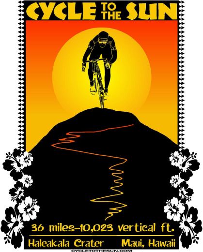


