


Hawaiian Islands weather details & Aloha paragraphs
Posted by GlennMarch 25-26 2008
Air Temperatures – The following maximum temperatures were recorded across the state of Hawaii Tuesday:
Lihue, Kauai – 82
Honolulu, Oahu – 86
Kaneohe, Oahu – 80
Kahului, Maui – 83
Hilo, Hawaii – 81
Kailua-Kona, Hawaii – 83
Temperatures ranged between these warmest and coolest spots near sea level at 4 p.m. Tuesday afternoon:
Honolulu, Oahu – 83F
Barking Sands, Kauai – 77
Precipitation Totals – The following numbers represent the largest precipitation totals (inches) during the last 24 hours on each of the major islands, as of Tuesday afternoon:
2.08 MOUNT WAIALEALE, KAUAI
0.24 OAHU FOREST NWR, OAHU
0.00 MOLOKAI
0.01 LANAI
0.00 KAHOOLAWE
0.65 PUU KUKUI, MAUI
1.19 GLENWOOD, BIG ISLAND
Weather Chart – Here’s the latest (automatically updated) weather map. A high pressure system is located far to the north of Hawaii Tuesday. Our local winds will be lighter from the east to southeast, then strengthen from the trade wind direction again Wednesday.
Satellite and Radar Images: To view the cloud conditions we have here in Hawaii, please use the following satellite links, starting off with the Infrared Satellite Image of the islands to see all the clouds around the state during the day and night. This next image is one that gives close images of the islands only during the daytime hours, and is referred to as a Close-up visible image. This next image shows a larger view of the Pacific…giving perspective to the wider ranging cloud patterns in the Pacific Ocean…out from the islands. To help you keep track of where any showers may be around the islands, here’s the latest animated radar image.
Hawaii’s Mountains – Here’s a link to the live webcam on the summit of near 14,000 foot Mauna Kea on the Big Island of Hawaii. The tallest peak on the island of Maui is the Haleakala Crater, which is near 10,000 feet in elevation. These two webcams are available during the daylight hours here in the islands…and when there’s a big moon rising just after sunset for an hour or two! Plus, during the nights and early mornings you will be able to see stars, and the sunrise too…depending upon cloud conditions.
Aloha Paragraphs
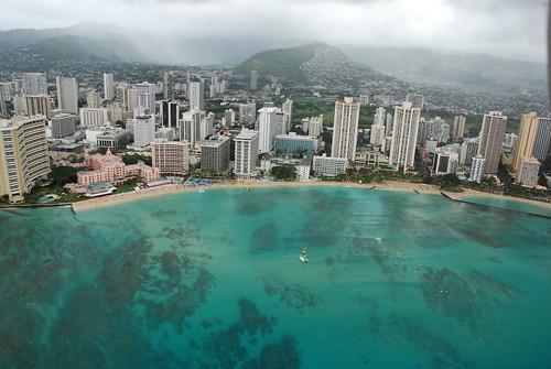
Waikiki Beach, Honolulu…Manoa Valley behind
Photo Credit: flikr.com
Our local winds were slightly lighter Tuesday, which will bounce back into the light to moderately strong range Wednesday. Weather maps show that a low pressure system to the northwest of Kauai, pushed our trade wind producing ridge of high pressure down closer to the islands. This in turn clocked our local winds around to the east-southeast locally. Winds from this direction put some parts of the state in a wind shadow behind the Big Island. As we get into Wednesday, the winds will likely turn back to the more customary easterly trade wind direction, and pick up a notch in strength. The trade winds will then continue through the rest of the week, strengthening further this weekend into next week.
There will be a few showers around, although nothing of particular note is expected. As the trade winds pick up some Wednesday, we’ll see the return of those normal passing showers along the windward coasts and slopes. The night and early morning hours will have the greatest likelihood of these few raindrops. The leeward sides will remain quite sunny and dry during the days, warm too. The Kona slopes on the Big Island, may see some late afternoon, or early evening showers falling locally.
It’s Tuesday evening as I begin updating this last paragraph of today’s narrative. As noted in the two paragraphs above, our weather here in the Hawaiian Islands will be just fine, really nice as a matter of fact! Our local beaches, at least most of them, basked in warm early spring sunshine Tuesday. I see no reason to believe that anything drastic will occur to change these positive weather conditions over the next couple of days, and for that matter…through the rest of this week. ~~~ Wednesday is a state holiday here in the islands, called Prince Kuhio Day. There’s a major parade that takes place in Honolulu, with marching bands, orchestras and color guards. It is celebrated to honor the birthday of Hawaii’s second delegate to Congress. Prince Kuhio was born in Koloa, Kauai, in 1871. As such, I have the day off from doing the tv weather show, and from regular day job in Kihei as well. ~~~ I’ll be back Wednesday morning nonetheless, with your next new weather narrative from paradise. I hope you have a great Tuesday night wherever you happen to be spending it! Aloha for now…Glenn.
Interesting: A vast ice shelf hanging on by a thin strip looks to be the next chunk to break off from the
Interesting2: The National Oceanic and Atmospheric Administration (NOAA) has this week highlighted the potential for major flooding across parts of the
Interesting3: A new study predicts water circulation in