


February 2-3, 2010
Air Temperatures – The following maximum temperatures were recorded across the state of Hawaii Tuesday afternoon:
Lihue, Kauai – 78
Honolulu, Oahu – 74
Kaneohe, Oahu – 76
Kaunakakai, Molokai – 72
Kahului, Maui – 74
Hilo, Hawaii – 85
Kailua-kona – 83
Air Temperatures ranged between these warmest and coolest spots near sea level around the state – and on the highest mountains…at 4pm Tuesday afternoon:
Kailua-kona – 81F
Molokai airport – 69
Haleakala Crater – 39 (near 10,000 feet on Maui)
Mauna Kea summit – 30 (near 14,000 feet on the Big Island)
Precipitation Totals – The following numbers represent the largest precipitation totals (inches) during the last 24 hours on each of the major islands, as of Tuesday afternoon:
1.01 Makaha Ridge, Kauai
1.77 Schofield South, Oahu
1.30 Molokai
0.39 Lanai
0.00 Kahoolawe
0.50 Kihei, Maui
0.10 Pohakuloa West, Big Island
Marine Winds – Here’s the latest (automatically updated) weather map showing a cold front is moving through the state. A new high pressure system will be moving into the area north of the islands…with cooler breezes from the north to northeast.
Satellite and Radar Images: To view the cloud conditions we have here in Hawaii, please use the following satellite links, starting off with this Infrared Satellite Image of the islands to see all the clouds around the state during the day and night. This next image is one that gives close images of the islands only during the daytime hours, and is referred to as a Close-up visible image. This next image shows a larger view of the Pacific…giving perspective to the wider ranging cloud patterns in the Pacific Ocean. Finally, here’s a Looping IR satellite image, making viewable the clouds around the islands 24 hours a day. To help you keep track of where any showers may be around the islands, here’s the latest animated radar image.
Hawaii’s Mountains – Here’s a link to the live webcam on the summit of near 14,000 foot Mauna Kea on the Big Island of Hawaii. The tallest peak on the island of Maui is the Haleakala Crater, which is near 10,000 feet in elevation. These two webcams are available during the daylight hours here in the islands…and when there’s a big moon rising just after sunset for an hour or two! Plus, during the nights and early mornings you will be able to see stars, and the sunrise too…depending upon weather conditions.
Tropical Cyclone activity in the eastern and central Pacific – Here’s the latest weather information coming out of the National Hurricane Center, covering the eastern north Pacific. You can find the latest tropical cyclone information for the central north Pacific (where Hawaii is located) by clicking on this link to the Central Pacific Hurricane Center. Here’s a tracking map covering both the eastern and central Pacific Ocean. A satellite image, which shows the entire ocean area between Hawaii and the Mexican coast…can be found here.
Aloha Paragraphs
Cooler…north to northeast breezes

Larger waves along our north and west facing beaches too
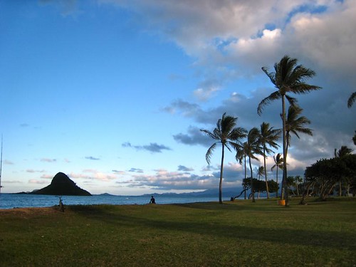
The approach of this latest cold front brought showers to Kauai and Oahu, and has reached down to
The computer models had shown all of the above, followed by a long lasting trade wind episode, now they’ve changed their tune…showing another couple of cold fronts arriving over the next week. Nonetheless, we will still see this two day cool snap after the cold front moves through our area. The latest idea includes another weak cold front late this weekend, followed by yet another around the middle of next week. At any rate, we’re still in our winter season, and so we expect these kinds of changeable conditions, it’s what makes following the weather so interesting! The changes presented by the computer models now show the trade winds, which will blow during the day Thursday, faltering already on Friday. As a matter of fact, the winds will shift all the way around to the southeast again, and probably to the south and southwest Kona directions, ahead of the next cold front later this weekend. Then, as has become so common this season, our winds will become north and northeast, and finally towards the ENE and easterly directions. Then, (there seems to be so many then’s this year) yet another cold front will arrive around next Tuesday or Wednesday…preceded by Kona winds, and followed by what else, other than more north to northeast breezes. We’re beginning to sound a bit like a broken record here! Although with that said, we’re happy to have any rainfall on any of our islands…as things remain drier than normal this winter.
It’s Tuesday evening, as I begin writing the last section of today’s narrative.
As described above, the majority of the remaining showers, some at least medium in intensity, if not a little more than that…are passing over Maui County. The showers, and most of the clouds have clear Kauai and Oahu, with just the rather insignificant cold front destined to pass quickly through tonight into Wednesday. This looping radar image
once again shows this situation well. I’m personally hoping that the Big Island, which has been particularly dry this winter, will get some of these showers soon! ~~~ Here in Kula this evening, it’s totally socked in with clouds above, and pea soup fog below…with still the Kona breezes blowing ahead of the frontal passage. The air temperature at a little past 5pm, was a chilly 59.5F degrees. Even down at Kapalua, near sea level, on Maui’s upper west side, at the same time…it was a chilly 70 degrees. What with the cooler breezes moving our way soon, the next day or day and a half, are going to be what winter is all about here in the tropics. We’ve had several of these cool snaps over the last several weeks. I know that many folks don’t appreciate these wintery outbreaks, and I can’t blame them, coming from colder places around the world. I grew up in southern California, and it never seemed to get cold enough for me there, so I sort of live for winter here in the tropics, so I can cool down once in a while. ~~~ Before anyone gets too nervous, this cool weather won’t last long, and already by later Thursday into Friday…our winds will swing around to the east and southeast even, carrying warmer air our way then. I’ll be back early Wednesday morning with your next new weather narrative from paradise, yes it is still paradise, despite the recent showers and cooler weather. I hope you have a great Tuesday night, and will be inclined to stop by for another visit soon! Aloha for now…Glenn.
Interesting: Humans and human activities have clearly altered the Earth’s landscape and oceans in countless ways, often to the detriment of other plants and animals. But a new report published online on January 28th in Current Biology, a Cell Press publication, shows just what a tangled food web we’ve woven. Two species of Mediterranean seabirds change their every move based on the activities of local fisheries and, in particular, the fish that people toss away.
The seabirds’ shifting movement patterns can be seen at the regional scale. "We show that human activities in the natural environment can promote critical transitions in the spreading properties of foraging animals by locally changing the predictability and availability of their resources," said Frederic Bartumeus of Princeton University and Institut Català de Ciències del Clima in Spain.
"Our study suggests an elementary but often disregarded connection between human local resource exploitation and global movement patterns of organisms." The findings may have important implications for conservation biology and the study of invasive species, the researchers said. The work also provides a solid statistical framework for quantifying movement patterns across ecological scales, which can now be applied to other species and other circumstances.
Bartumeus’ team took advantage of existing satellite data on the Cory’s shearwater and the Balearic shearwater, which tracked the seabirds’ movement over multiple foraging trips. Each trip typically lasts less than two days and covers distances anywhere from 10 to 1000 kilometers. Because the fisheries don’t operate on holidays and weekends, the researchers were able to characterize the birds’ activities in the presence and in the absence of the fisheries’ trawling activities.
When the fisheries don’t operate, seabirds essentially combine local searching with very large traveling distances, Bartumeus explained. Such a multi-scale search pattern generates what he calls super-diffusive movement properties, meaning that the birds spread out from one another at a rate that accelerates over time.
"Such a movement pattern allows for efficient explorations when the birds are looking for their natural prey of small fish and squid, which are highly mobile and unpredictably distributed in space and time," he said. In contrast, when fishermen are discarding fish, seabirds perform local searches around the boats, which act as an "attracting force."
As a result of such confined movement, the spreading of scavenging seabirds in the seascape decelerates with time, and movement patterns involve well-defined spatial scales related to the fishery activity. In a nutshell, says Bartumeus: "Fishery activities impact the foraging ecology of seabirds at much larger spatiotemporal scales than one might expect intuitively. The macroscopic spreading properties of seabirds through the seascape are directly influenced by the presence of fishermen’s boats discarding fish."
Interesting2: Speed is not a word typically associated with trees; they can take centuries to grow. However, a new study in the Proceedings of the National Academy of Sciences has found evidence that forests in the Eastern United States are growing faster than they have in the past 225 years. The study offers a rare look at how an ecosystem is responding to climate change. For more than 20 years forest ecologist Geoffrey Parker has tracked the growth of 55 stands of mixed hardwood forest plots in Maryland.
The plots range in size, and some are as large as 2 acres. Parker’s research is based at the Smithsonian Environmental Research Center, 26 miles east of the nation’s capital. Parker’s tree censuses have revealed that the forest is packing on weight at a much faster rate than expected. He and Smithsonian Tropical Research Institute postdoctoral fellow Sean McMahon discovered that, on average, the forest is growing an additional 2 tons per acre annually.
That is the equivalent of a tree with a diameter of 2 feet sprouting up over a year. Forests and their soils store the majority of the Earth’s terrestrial carbon stock. Small changes in their growth rate can have significant ramifications in weather patterns, nutrient cycles, climate change and biodiversity. Exactly how these systems will be affected remains to be studied. Parker and McMahon’s paper focuses on the drivers of the accelerated tree growth.
The chief culprit appears to be climate change, more specifically, the rising levels of atmospheric CO2, higher temperatures and longer growing seasons. Assessing how a forest is changing is no easy task. Forest ecologists know that the trees they study will most likely outlive them. One way they compensate for this is by creating a "chronosequence" — a series of forests plots of the same type that are at different developmental stages.
At SERC, Parker meticulously tracks the growth of trees in stands that range from 5 to 225 years old. This allowed Parker and McMahon to verify that there was accelerated growth in forest stands young and old. More than 90% of the stands grew two to four times faster than predicted from the baseline chronosequence. By grouping the forest stands by age, McMahon and Parker were also able to determine that the faster growth is a recent phenomenon.
If the forest stands had been growing this quickly their entire lives, they would be much larger than they are. Parker estimates that among himself, his colleague Dawn Miller and a cadre of citizen scientists, they have taken a quarter of a million measurements over the years. Parker began his tree census work Sept. 8, 1987 — his first day on the job. He measures all trees that are 2 centimeters or more in diameter. He also identifies the species, marks the tree’s coordinates and notes if it is dead or alive.
By knowing the species and diameter, McMahon is able to calculate the biomass of a tree. He specializes in the data-analysis side of forest ecology. "Walking in the woods helps, but so does looking at the numbers," said McMahon. He analyzed Parker’s tree censuses but was hungry for more data. It was not enough to document the faster growth rate; Parker and McMahon wanted to know why it might be happening.
"We made a list of reasons these forests could be growing faster and then ruled half of them out," said Parker. The ones that remained included increased temperature, a longer growing season and increased levels of atmospheric CO2. During the past 22 years CO2 levels at SERC have risen 12%, the mean temperature has increased by nearly three-tenths of a degree and the growing season has lengthened by 7.8 days.
The trees now have more CO2 and an extra week to put on weight. Parker and McMahon suggest that a combination of these three factors has caused the forest’s accelerated biomass gain. Ecosystem responses are one of the major uncertainties in predicting the effects of climate change.
Parker thinks there is every reason to believe his study sites are representative of the Eastern deciduous forest, the regional ecosystem that surrounds many of the population centers on the East Coast. He and McMahon hope other forest ecologists will examine data from their own tree censuses to help determine how widespread the phenomenon is.
Interesting3: NASA’s Hubble Space Telescope has observed a mysterious X-shaped debris pattern and trailing streamers of dust that suggest a head-on collision between two asteroids. Astronomers have long thought the asteroid belt is being ground down through collisions, but such a smashup has never been seen before. Asteroid collisions are energetic, with an average impact speed of more than 11,000 miles per hour, or five times faster than a rifle bullet.
The comet-like object imaged by Hubble, called P/2010 A2, was first discovered by the Lincoln Near-Earth Asteroid Research, or LINEAR, program sky survey on Jan. 6. New Hubble images taken on Jan. 25 and 29 show a complex X-pattern of filamentary structures near the nucleus. "This is quite different from the smooth dust envelopes of normal comets," said principal investigator David Jewitt of the University of California at Los Angeles.
"The filaments are made of dust and gravel, presumably recently thrown out of the nucleus. Some are swept back by radiation pressure from sunlight to create straight dust streaks. Embedded in the filaments are co-moving blobs of dust that likely originated from tiny unseen parent bodies." Hubble shows the main nucleus of P/2010 A2 lies outside its own halo of dust. This has never been seen before in a comet-like object.
The nucleus is estimated to be 460 feet in diameter. Normal comets fall into the inner regions of the solar system from icy reservoirs in the Kuiper Belt and Oort Cloud. As a comet nears the sun and warms up, ice near the surface vaporizes and ejects material from the solid comet nucleus via jets. But P/2010 A2 may have a different origin. It orbits in the warm, inner regions of the asteroid belt where its nearest neighbors are dry rocky bodies lacking volatile materials.
This leaves open the possibility that the complex debris tail is the result of an impact between two bodies, rather than ice simply melting from a parent body. "If this interpretation is correct, two small and previously unknown asteroids recently collided, creating a shower of debris that is being swept back into a tail from the collision site by the pressure of sunlight," Jewitt said. The main nucleus of P/2010 A2 would be the surviving remnant of this so-called hypervelocity collision.
"The filamentary appearance of P/2010 A2 is different from anything seen in Hubble images of normal comets, consistent with the action of a different process," Jewitt said. An impact origin also would be consistent with the absence of gas in spectra recorded using ground-based telescopes. The asteroid belt contains abundant evidence of ancient collisions that have shattered precursor bodies into fragments.
The orbit of P/2010 A2 is consistent with membership in the Flora asteroid family, produced by collisional shattering more than 100 million years ago. One fragment of that ancient smashup may have struck Earth 65 million years ago, triggering a mass extinction that wiped out the dinosaurs.
But, until now, no such asteroid-asteroid collision has been caught "in the act." At the time of the Hubble observations, the object was approximately 180 million miles from the sun and 90 million miles from Earth. The Hubble images were recorded with the new Wide Field Camera 3 (WFC3).
Interesting4: Brazil’s government has granted an environmental license for the construction of a controversial hydroelectric dam in the heart of the Amazon rainforest, the Environment Minister said on Monday. The $17 billion project on the Xingu River in the northern state of Para is to help the fast-growing Latin American country cope with soaring demand for electricity but has raised concern over its likely impact on the environment and on native Indians.
"It may have been the slowest and most complicated process under my management, after all, it is the third largest in the world … and a very controversial project," Environment Minister Carlos Minc told reporters in Rio de Janeiro. The 11,000-megawatt Belo Monte dam is part of Brazil’s largest concerted development plan for the Amazon since the country’s military government cut highways through the rain forest to settle the vast region during its two-decade reign starting in 1964.
Dams, roads, gas pipelines and power grids worth more than $30 billion are being built to tap the region’s vast raw materials, and transport its agricultural products in coming years. Minc said 96.5 sq miles of land would be flooded by the Belo Monte dam and that this had been reduced from 5,000 in the original plans for ecological reasons. Environmental groups say the Belo Monte project, which also includes creating a waterway to transport agricultural commodities grown in the Amazon, would damage the sensitive ecosystem with the flooding and threaten some fish species.
Jeep Says:
Glen – I’ve been watching the rapid increase in clouds over the El Nino ‘warm pool’ in mid-Pacific. And it seems there is cross equatorial flow of clouds and moisture heading toward Hawaii.
I’d appreciate your writing me a few sentences giving me your take on this change in the appearance of El Nino.
Hope you are rested and healthy and happy.
Jeep~~~Hi Jeep, you are correct in your assessment. There is a big storm down near Bora Bora, in the south Pacific…on the other side of the equator below Hawaii. Here’s a satellite http://www.weatheroffice.gc.ca/data/satellite/goes_gwdisk11_1070_100.jpg – that shows this well. The part of the current we are getting is carrying high cirrus clouds northward from the deeper tropics. Meanwhile, we have a cold front about to progress down through the island chain…with another one or two on tap to follow through the next week. Aloha, Glenn