Temperatures early Tuesday morning ranged between these warmest and coolest spots near sea level at the 4 a.m. hour:
HONOLULU, OAHU – 77 HILO AIRPORT – 69
Precipitation Totals – The following numbers represent the largest precipitation totals (inches) during the last 24 hours (as of Tuesday morning) on each of the major islands:
Weather Chart – Here’s the latest (automatically updated) weather map…showing a moderately strong 1034 millibar high pressure system located far to the NW of our islands. Meanwhile, a trough of low pressure will pass close to the state Tuesday…keeping our local winds light east to SE. This trough will move away to the north Wednsday, allowing the trade winds to return then. Here’s a Weather Map Symbol page for clarification about what all those weather symbols mean on the map.
Hawaii’s Mountains – Here’s a link to the live webcam on the summit of near 14,000 foot Mauna Kea on the Big Island of Hawaii. The tallest peak on the island of Maui is the Haleakala Crater, which is near 10,000 feet in elevation. These two webcams are available during the daylight hours here in the islands…and when there’s a big moon rising just after sunset for an hour or two! Plus, during the nights and early mornings you will be able to see stars, and the sunrise too…depending upon cloud conditions.
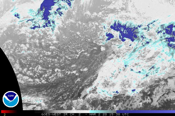
Satellite Images – To view the cloud conditions we have here in Hawaii, please use the following satellite links, starting off with the Infrared Satellite Image of the islands to see all the clouds around the state during the day and night. This next image is one that gives close images of the islands only during the daytime hours, and is referred to as a Close-up visible image. This next image shows a larger view of the Pacific…giving perspective to the wider ranging cloud patterns in the Pacific Ocean…out from the islands. To help you keep track of where any showers may be around the islands, here’s the latest animated radar image.
Tropical Cyclone Activity – The eastern Pacific hurricane season runs from May 15 through November 30…while the central Pacific (where Hawaii is) runs from June 1 through November 30. The latest storm information for the eastern Pacific can be found by clicking here. A storm tracking map for both the central and eastern areas can be found by clicking here . For the central Pacific, the latest storm information can be found by clicking here.
Aloha Paragraphs
Large summer waves in Hawaiinow…
A low pressure system aloft will at least partially block our regular summer trade winds through Tuesday. This will have several influences in our HawaiianIsland weather picture…not the least of which will be to keep our overlying atmosphere quite sultry and humid. As this trough of low pressure passes across our area of the central north Pacific, our winds will be much lighter than normal for this time of year. The late July, early August sunshine meanwhile will be beaming down like crazy, with hot and muggy weather conditions making for a somewhat uncomfortable reality for a couple of days. All that sunshine, combined with the humid air, will be the ingredients for shower prone conditions. The presence of the cold air aloft, in association the low pressure around now, will make for an unstable air mass. All of this will add up to an increased chance of afternoon cumulus cloud buildups over the interior sections of all the islands now. Those towering clouds will drop showers locally, some of which will be locally heavy. As the sun goes down, the islands will stop being “heating pads”, and the clouds will evaporate in most areas.
We call these types of meteorological conditions a convective weather pattern. Often we start off with slightly cooler than normal temperatures early on, then as the day progresses, we see that afternoon cloudiness described above. There’s a chance that we could some of those showers become localized flooders, although that would be only here and there at most. The expectation is that this rainfall inducing trough of low pressure will move away to the NW by Wednesday. This in turn will make way for the return of a regular trade wind weather pattern…putting an end to the sultry conditions, and returning the bias for showers to the windward sides.
The big news in Hawaii now, besides the unusual weather caused by the low pressure system, is the larger than normal surf along our south and west facing beaches. These waves were generated by a deep winter storm in the southern hemisphere more than a week ago. This storm had hurricane force winds revolving around its center, down near New Zealand. It has triggered a high surf advisory along our leeward beaches, which means that folks here in the islands should exercise caution when entering the ocean. A second reinforcing SSW swell will arrive around mid-week, which will keep the larger than normal surf around through the rest of this week.
It’s early Monday evening here in Kula, Maui, as I begin writing this sunset commentary. It was a hot day, especially down near the beaches. Case in point, the Kahului airport hit 91F degrees in the afternoon, while Kihei and Lahaina both were at least that hot…and perhaps a degree or two more. There was lots of sunshine at most coastal locations, although clouds stacked-up nicely, right on schedule, during the afternoon hours over and around the mountains. [There was a brief period of flooding rainfall that fell over parts of Oahu Monday afternoon.] As I was driving home, coming up past Pukalani, it started to rain, with the roads wet all the way to my house in upper Kula. Glancing back downcountry, it appears that the clouds have slid down towards the beaches now, although I don’t see any precipitation falling down there. I’m quite sure, due to the factors described in the paragraphs above, that we’ll see a repeat performance of today on Tuesday. By the way, we have two new tropical cyclones now active in the eastern Pacific, neither of which are a threat to our Hawaiian Islands. I hope you have a good Monday night, and that you will join me here again on Tuesday, for more updated weather information then. Aloha for now…Glenn.
By the way, you may notice that the activity pages on this website look much better now, thanks toBumpnetworks, who are both my friends, and also my valued website host! The team at Bump Networks provides custom software solutions, web solutions and hardware interfaces for a variety of clients. They’ve built software and web solutions for clients in many industries including high-tech, entertainment, travel, tour operator, GPS, disaster prevention and management, and government/DOD.
Temperatures early Monday morning ranged between these warmest and coolest spots near sea level at the 4 a.m. hour:
KANEOHE, OAHU – 78 KAHULUI AND MOLOKAI AIRPORTS – 67
Precipitation Totals – The following numbers represent the largest precipitation totals (inches) during the last 24 hours (as of Monday morning) on each of the major islands:
0.75 MOUNT WAIALEALE, KAUAI 0.14 MANOA LYON ARBORETUM, OAHU 0.00 MOLOKAI 0.00 LANAI 0.00 KAHOOLAWE 0.07 HANA AIRPORT, MAUI 1.62 HONAUNAU, BIG ISLAND
Weather Chart – Here’s the latest (automatically updated) weather map…showing a strong 1037 millibar high pressure system located far to the NNW of our islands. Meanwhile, a trough of low pressure will pass close to the state Monday, ending up to the NW Tuesday…weakening our local winds, turning them light east to SE. Here’s a Weather Map Symbol page for clarification about what all those weather symbols mean on the map.
Hawaii’s Mountains – Here’s a link to the live webcam on the summit of near 14,000 foot Mauna Kea on the Big Island of Hawaii. The tallest peak on the island of Maui is the Haleakala Crater, which is near 10,000 feet in elevation. These two webcams are available during the daylight hours here in the islands…and when there’s a big moon rising just after sunset for an hour or two! Plus, during the nights and early mornings you will be able to see stars, and the sunrise too…depending upon cloud conditions.
Satellite Images – To view the cloud conditions we have here in Hawaii, please use the following satellite links, starting off with the Infrared Satellite Image of the islands to see all the clouds around the state during the day and night. This next image is one that gives close images of the islands only during the daytime hours, and is referred to as a Close-up visible image. This next image shows a larger view of the Pacific…giving perspective to the wider ranging cloud patterns in the Pacific Ocean…out from the islands. To help you keep track of where any showers may be around the islands, here’s the latest animated radar image.
Tropical Cyclone Activity – The eastern Pacific hurricane season runs from May 15 through November 30…while the central Pacific (where Hawaii is) runs from June 1 through November 30. The latest storm information for the eastern Pacific can be found by clicking here. A storm tracking map for both the central and eastern areas can be found by clicking here . For the central Pacific, the latest storm information can be found by clicking here.
Aloha Paragraphs
Another Georgeous sunset in Hawaii… Photo Credit: Kona boy
The latest forecasts continue to point out the chance of an unusual weather circumstance for the first couple of days of the new week ahead…after a nice day Sunday.An upper level low pressure system is forecast to move near the state Monday and Tuesday, bringing lighter winds, and chance of locally heavy afternoon showers forming then. We will feel hot and muggy too, as humid air comes up from the SE, with some possible volcanic haze spreading from the Big Island up to Maui County then as well. Hawaii’s weather will turn back towards a more normal trade wind weather pattern, as we get to the mid-week point and beyond.
It’s early Sunday evening here in Kula, Maui, as I start this sunset commentary. As you read in the paragraph above, we have sultry and shower prone atmospherics heading our way. It will be tough to pinpoint exactly where, or how much rain will fall over the next couple of days, but the dynamics will be in place for some very generous amounts here and there! On another note, I had a great surfing experience this morning on the Lahaina side, really fun larger than normal waves to ride. It finally got so crowded that I had to paddle in, reluctantly I might add. I took the rest of the day off, and am reading a very interesting book, about a destitute family who lives in Ireland. It’s a Pulitzer Prize winner, and I’ll give you the name of it soon, as it’s downstairs and I’m too lazy to go down and get it at the moment. It’s been that kind of day, just hang loose, laying around reading, a few quick naps, with an occasional plate of red sauce pasta. On the one hand I’m sorry to see the weekend coming to a close, and on the other, looking forward to another week of weather work ahead. I hope you have a great Sunday night, and that you will meet me here again on Monday, when I’ll have a new narrative waiting for you early on. Aloha for now…Glenn.
By the way, you may notice that the activity pages on this website look renewed again, thanks toBumpnetworks, who are both my friends, and also my valued website host! The team at Bump Networks provides custom software solutions, web solutions and hardware interfaces for a variety of clients. They’ve built software and web solutions for clients in many industries including high-tech, entertainment, travel, tour operator, GPS, disaster prevention and management, and government/DOD.
Temperatures early Sunday morning ranged between these warmest and coolest spots near sea level at the 4 a.m. hour:
KANEOHE, OAHU – 78 HILO AIRPORT – 73
Precipitation Totals – The following numbers represent the largest precipitation totals (inches) during the last 24 hours (as of Sunday morning) on each of the major islands:
0.23 MOUNT WAIALEALE, KAUAI 0.19 POAMOHO 2, OAHU 0.02 MOLOKAI 0.01 LANAI 0.00 KAHOOLAWE 0.99 WEST WAILUAIKI, MAUI 3.82 WAIAHA, BIG ISLAND
Weather Chart – Here’s the latest (automatically updated) weather map…showing a relatively strong 1037 millibar high pressure system located far to the NNW of our islands. This high pressure cell will keep moderately strong trade winds blowing Sunday. A trough of low pressure will pass close to the state Monday, ending up to the NW Tuesday…weakening our local trade winds, eventually turning them SE. Here’s a Weather Map Symbol page for clarification about what all those weather symbols mean on the map.
Hawaii’s Mountains – Here’s a link to the live webcam on the summit of near 14,000 foot Mauna Kea on the Big Island of Hawaii. The tallest peak on the island of Maui is the Haleakala Crater, which is near 10,000 feet in elevation. These two webcams are available during the daylight hours here in the islands…and when there’s a big moon rising just after sunset for an hour or two! Plus, during the nights and early mornings you will be able to see stars, and the sunrise too…depending upon cloud conditions.
Satellite Images – To view the cloud conditions we have here in Hawaii, please use the following satellite links, starting off with the Infrared Satellite Image of the islands to see all the clouds around the state during the day and night. This next image is one that gives close images of the islands only during the daytime hours, and is referred to as a Close-up visible image. This next image shows a larger view of the Pacific…giving perspective to the wider ranging cloud patterns in the Pacific Ocean…out from the islands. To help you keep track of where any showers may be around the islands, here’s the latest animated radar image.
Tropical Cyclone Activity – The eastern Pacific hurricane season runs from May 15 through November 30…while the central Pacific (where Hawaii is) runs from June 1 through November 30. The latest storm information for the eastern Pacific can be found by clicking here. A storm tracking map for both the central and eastern areas can be found by clicking here . For the central Pacific, the latest storm information can be found by clicking here.
Aloha Paragraphs
Lovely…
The cloud field associated with former tropical cyclone Daniel moved through the islands Friday. We saw some showers, although most of those were restricted for the most part to the windward and mountain areas. The largest amounts were 1.00+ inches generally, although just under 4.00 inches fell at one gauge along the Hana coast of east Maui. Weather conditions will improve this weekend in the wake of Daniel, although there will still be showers along the windward sides…and around the mountains locally during the afternoons. The latest computer forecast models are pointing out the chance of another unusual weather circumstance for the first couple of days of the new week ahead.An upper level low pressure system is forecast to move near the state on Monday and Tuesday, with light winds, and chance of locally heavy afternoon showers forming then. We will feel rather hot and muggy then too, as our air comes up from the SE, with some possible volcanic haze spreading from the Big Island up to Maui County then as well.
It’s early Saturday evening here in Kula, Maui, as I start this evening’s sunset commentary. The air is so soft, the sunshine is so warm on my bare shoulders, and the quiet is so comforting to my body and soul. There are left over clouds from Daniel, and then some just regular ones too. I must say I just love Maui! I just got off the telephone with a lady friend in Marin County, northern California. She was saying she heard that a well known Zen Master, named Suzuki Roshi, was asked on his death bed, "what is the truth?" His reply was: "Everything Changes." I made a red sause pasta sauce, very basic, red onions, garlic, sauteed in extra virgin olive oil, with fresh picked basil from the garden. I’m sipping on my new favorite ale, called IPA. A friend from work called and invited me out to the movies with he and his wife tonight, I didn’t go, needing to pull back from the busy life for a full 24 hours. At any rate, I have plans to meet them early Sunday morning for an early surfing session. Have a good one, Aloha…Glenn.
By the way, you may notice that the activity pages on this website look renewed again, thanks toBumpnetworks, who are both my friends, and also my valued website host! The team at Bump Networks provides custom software solutions, web solutions and hardware interfaces for a variety of clients. They’ve built software and web solutions for clients in many industries including high-tech, entertainment, travel, tour operator, GPS, disaster prevention and management, and government/DOD.
Temperatures early Saturday morning ranged between these warmest and coolest spots near sea level at the 5 a.m. hour:
KAILUA-KONA – 79 HILO AIRPORT – 71
Precipitation Totals – The following numbers represent the largest precipitation totals (inches) during the last 24 hours (as of Saturday morning) on each of the major islands:
1.99 MOUNT WAIALEALE, KAUAI 1.43 MANOA LYON ARBORETUM, OAHU 0.03 MOLOKAI 0.06 LANAI 0.00 KAHOOLAWE 3.93 WEST WAILUAIKI, MAUI 2.13 MOUNTAIN VIEW, BIG ISLAND
Weather Chart – Here’s the latest (automatically updated) weather map…showing a relatively strong 1039 millibar high pressure system located to the NNW of our islands. This high pressure cell will keep moderately strong trade winds blowing…locally quite gusty during the afternoons Saturday, then somewhat lighter Sunday. Here’s a Weather Map Symbol page for clarification about what all those weather symbols mean on the map.
Hawaii’s Mountains – Here’s a link to the live webcam on the summit of near 14,000 foot Mauna Kea on the Big Island of Hawaii. The tallest peak on the island of Maui is the Haleakala Crater, which is near 10,000 feet in elevation. These two webcams are available during the daylight hours here in the islands…and when there’s a big moon rising just after sunset for an hour or two! Plus, during the nights and early mornings you will be able to see stars, and the sunrise too…depending upon cloud conditions.
Satellite Images – To view the cloud conditions we have here in Hawaii, please use the following satellite links, starting off with the Infrared Satellite Image of the islands to see all the clouds around the state during the day and night. This next image is one that gives close images of the islands only during the daytime hours, and is referred to as a Close-up visible image. This next image shows a larger view of the Pacific…giving perspective to the wider ranging cloud patterns in the Pacific Ocean…out from the islands. To help you keep track of where any showers may be around the islands, here’s the latest animated radar image.
Tropical Cyclone Activity – The eastern Pacific hurricane season runs from May 15 through November 30…while the central Pacific (where Hawaii is) runs from June 1 through November 30. The latest storm information for the eastern Pacific can be found by clicking here. A storm tracking map for both the central and eastern areas can be found by clicking here . For the central Pacific, the latest storm information can be found by clicking here.
Aloha Paragraphs
High surf advisory on the leeward beaches of Hawaii now…
The trough associated with a tropical disturbance, which was former tropical cyclone Daniel, is moving away from the Hawaiian Islands late in the day Friday. Looking at what is left of this former tropical system, using this lastest animated satellite image, we can see that the large compex of thunderstorms has dissipated considerably from what we saw earlier in the day Friday. We had some pretty good showers falling over the Big Island and Maui County at times during the day. The winds that will influence the islands now into Saturday, which will be locally gusty trade winds, aren’t a part of the trough itself. Rather, they will be associated with the steep pressure gradient (like a slope) between a very strong 1040 millibar high pressure system far to our north, as this low pressure vortex passes by to our south.
NOTICE:A flash flood watch for Maui and the Big Island, Lanai and Molokai was cancelled late Friday afternoon.
The latest computer forecast models are pointing out the chance of another unusual weather circumstance for early next week. A deep upper level low is forecast to move near the state on Monday and Tuesday, with light winds, and chance of locally heavy afternoon showers forming then. 2006 has been one of those years that wants to continually deviate from the norm!
It’s late Friday afternoon here in Kihei, Maui, as I update this last paragraph of today’s narrative. Watching the satellite images today, as those thunderstorms and heavy rain bearing clouds moved over the Big Island and a small part of Maui…was quite interesting. It reminded me of a water balloon, that got poked by the tall summits on the Big Island, as they quickly fell apart soon after arrival! The latest images showed what was left of those clouds moving northward away from the islands. On the one hand, I suppose that is a good thing, although we could really have used some more rain, as our water reservoirs here on Maui are getting lower than we like them to be. I must admit it has been a very big week in this Maui weatherman’s life, busy, busy, busy! It will feel good to have a couple of days off from work. I see the computer forecast models are trying to spin up the next tropical storm in the eastern Pacific now. Here’s a satellite image of that area so that you can check it out too…it’s those clouds well south of the southern tip of Baja, California. I’m going to look in the paper now, and see if there’s a film that I’d like see tonight. Everytime I go out in public now, I’m constantly asked about the weather, so it will be good to sort of "escape the weather" for a couple of hours, to the privacy of a dark theatre! I’ll be back here early Saturday morning with the next narrative updates. I hope you have a great Friday night! Aloha for now…Glenn.
I want to highlight another of the advertisers on my website today, this time its Hana Botanicals – Island Gifts. To capture the essence of Hana, Maui…Hana Botanicals has created an exclusive line of hand poured candles and handcrafted bath and body products including soaps, lotions, shower gels, bath salts, and luxury body oils. Custom blended in their Maui studio, they use only the finest ingredients that Mother Nature and Father Earth provide. Each of their products are designed to sooth the senses!
By the way, you may notice that the activity pages on this website look renewed again, thanks to Bumpnetworks, who are both my friends, and also my valued website host! The team at Bump Networks provides custom software solutions, web solutions and hardware interfaces for a variety of clients. They’ve built software and web solutions for clients in many industries including high-tech, entertainment, travel, tour operator, GPS, disaster prevention and management, and government/DOD.
Temperatures early Friday morning ranged between these warmest and coolest spots near sea level at the 4 a.m. hour:
HONOLULU AIRPORT – 78 HILO AIRPORT – 73
Precipitation Totals – The following numbers represent the largest precipitation totals (inches) during the last 24 hours (as of Friday morning) on each of the major islands:
1.86 MOUNT WAIALEALE, KAUAI 0.24 PUNALUU PUMP, OAHU 0.01 MOLOKAI 0.00 LANAI 0.00 KAHOOLAWE 0.61 HAIKU, MAUI 0.24 WAIAKEA UKA, BIG ISLAND
Weather Chart – Here’s the latest (automatically updated) weather map…showing a relatively strong 1034 millibar high pressure system located to the NNE of our islands. This high pressure cell will keep moderately strong trade winds blowing…locally quite strong and gusty during the afternoons. Here’s a Weather Map Symbol page for clarification about what all those weather symbols mean on the map.
Hawaii’s Mountains – Here’s a link to the live webcam on the summit of near 14,000 foot Mauna Kea on the Big Island of Hawaii. The tallest peak on the island of Maui is the Haleakala Crater, which is near 10,000 feet in elevation. These two webcams are available during the daylight hours here in the islands…and when there’s a big moon rising just after sunset for an hour or two! Plus, during the nights and early mornings you will be able to see stars, and the sunrise too…depending upon cloud conditions.
Satellite Images – To view the cloud conditions we have here in Hawaii, please use the following satellite links, starting off with the Infrared Satellite Image of the islands to see all the clouds around the state during the day and night. This next image is one that gives close images of the islands only during the daytime hours, and is referred to as a Close-up visible image. This next image shows a larger view of the Pacific…giving perspective to the wider ranging cloud patterns in the Pacific Ocean…out from the islands. To help you keep track of where any showers may be around the islands, here’s the latest animated radar image.
Tropical Cyclone Activity – The eastern Pacific hurricane season runs from May 15 through November 30…while the central Pacific (where Hawaii is) runs from June 1 through November 30. The latest storm information for the eastern Pacific can be found by clicking here. A storm tracking map for both the central and eastern areas can be found by clicking here . For the central Pacific, the latest storm information can be found by clicking here.
Aloha Paragraphs
Larger than normal south shore waves in Hawaii now … Photo Credit: Sean Davey
The center of a tropical disturbance, which was former tropical cyclone Daniel, is now within 200 miles ESE of Hilo, on the Big Island early Friday morning. Looking at what is left of this former tropical system, using this lastest animated satellite image, we can see that there’s still quite a large field of clouds to the east of the Islands. This vortex, or remnant tropical low pressure system, is expected to start moving through the Hawaii islands early Friday morning. We’ll see an increase in showers over all the islands when the northern fringe of these clouds arrive, especially over the Big Island and Maui County. The winds that will influence the islands then, which will be locally gusty trade winds, won’t be part of the disturbance itself. Rather, they will be associated with the steep pressure gradient (like a slope) between a strong 1037 millibar high pressure system far to our north, and the tropical low pressure vortex of former Daniel as it passes by to our south.
The link to that satellite image above shows a rather impressive field of clouds, which has a large thunderstorm complex to the north of its center point, growing to near 45,000 feet early Friday morning! This suggests that we may be in for quite a lot of rain, especially if these thunderstorms remain active when this area of clouds moves through the state early Friday morning into Saturday morning. This brings up the possibility of localized flooding, which certainly isn’t out of the question!
NOTICE:A flash flood watch is in effect for Maui and the Big Island, Lanai and Molokai early Friday morning.
As you can surmise from the information above, we’re still intimately involved in the prospect of a locally breezy and wet weather outlook from the remnant circulation of former Daniel. The computer forecast models go on to point out the chance of another very unusual weather circumstance for early next week. A deep upper level low is forecast to move near the state by Monday and Tuesday, with light winds, and chance of locally heavy afternoon showers, or maybe even an isolated thunderstorm. 2006 has been one of those years that wants to continually deviate from the norm!
It’s just now sunset time here in Kula, Maui, as I begin this sunset commentary. Looking over at the windward side of east Maui, I see thick clouds, which are dropping showers. The leeward areas around Kihei and Lahaina saw a nice mostly clear skied sunset, while here in upcountry Kula, it’s partly cloudy and dry. Now that the NWS has issued a flash flood watch, and with obvious rain bearing clouds moving in our direction, it brings things to a head, so to speak. I think folks, especially those on the windward sides, should be prepared for locally heavy rains during the next 24 hours. It’s one of those times, as you can see from the satellite link provided about three paragraphs up this page, that it’s starting to seem imminent. I’d say get ready for some good old fashioned rains, and with some possible lightning and thunder too in places. I’ll be back very early Friday morning with the latest information about this situation, be well until then. Aloha for now…Glenn.
I want to highlight another of the advertisers on my website today, this time its Hawaiian Music from Maui. Ulu Loa, the producers of this Hawaiian Music, is situated on the slopes of Haleakala in Haiku, Maui, and embodies the things represented by our logo. In addition to our home and the bounty of its land, it is home to Ulu Loa Studio and Ululoa Productions. Together with the artists, Ulu Loa is a family dedicated to producing quality Hawaiian music that honors tradition and culture and speaks to the heart…celebrating the Spirt of the islands.
By the way, you may notice that the activity pages on this website look renewed again, thanks to Bumpnetworks, who are both my friends, and also my valued website host! The team at Bump Networks provides custom software solutions, web solutions and hardware interfaces for a variety of clients. They’ve built software and web solutions for clients in many industries including high-tech, entertainment, travel, tour operator, GPS, disaster prevention and management, and government/DOD.
Temperatures early Thursday morning ranged between these warmest and coolest spots near sea level at the 4 a.m. hour:
KAILUA-KONA – 77 HILO AIRPORT – 68
Precipitation Totals – The following numbers represent the largest precipitation totals (inches) during the last 24 hours (as of Thursday morning) on each of the major islands:
0.77 MOUNT WAIALEALE, KAUAI 0.13 WILSON TUNNEL, OAHU 0.00 MOLOKAI 0.00 LANAI 0.00 KAHOOLAWE 0.08 WEST WAILUAIKI, MAUI 0.50 LAUPAHOEHOE, BIG ISLAND
Weather Chart – Here’s the latest (automatically updated) weather map…showing a relatively strong 1034 millibar high pressure system located to the NNE of our islands. This high pressure cell will keep moderately strong trade winds blowing…locally quite strong and gusty during the afternoons. Here’s a Weather Map Symbol page for clarification about what all those weather symbols mean on the map.
Hawaii’s Mountains – Here’s a link to the live webcam on the summit of near 14,000 foot Mauna Kea on the Big Island of Hawaii. The tallest peak on the island of Maui is the Haleakala Crater, which is near 10,000 feet in elevation. These two webcams are available during the daylight hours here in the islands…and when there’s a big moon rising just after sunset for an hour or two! Plus, during the nights and early mornings you will be able to see stars, and the sunrise too…depending upon cloud conditions.
Satellite Images – To view the cloud conditions we have here in Hawaii, please use the following satellite links, starting off with the Infrared Satellite Image of the islands to see all the clouds around the state during the day and night. This next image is one that gives close images of the islands only during the daytime hours, and is referred to as a Close-up visible image. This next image shows a larger view of the Pacific…giving perspective to the wider ranging cloud patterns in the Pacific Ocean…out from the islands. To help you keep track of where any showers may be around the islands, here’s the latest animated radar image.
Tropical Cyclone Activity – The eastern Pacific hurricane season runs from May 15 through November 30…while the central Pacific (where Hawaii is) runs from June 1 through November 30. The latest storm information for the eastern Pacific can be found by clicking here. A storm tracking map for both the central and eastern areas can be found by clicking here . For the central Pacific, the latest storm information can be found by clicking here.
Aloha Paragraphs
The golden glow of Kona… Photo Credit: Konaboy
Favorably inclined trade wind weather will continue across the Hawaiian Islands through Thursday. Skies will be quite clear to partly cloudy in general. Many rain gauges around the state have remained dry during the last 24 hours, although some windward biased showers will fall at times. The trade winds will be quite light during the morning hours, then getting stronger and more gusty during the afternoons as usual.
Tropical disturbance Daniel continues to wind down approximately 700 miles ESE of Hilo, Hawaii early Wednesday evening. Looking at what is left of this former tropical depression, using this lastest satellite image, we can see that there is a swirl of low clouds to the ESE of the Big Island. This vortex, or remnant tropical low pressure system, is expected to move by south of Hawaii Friday into Saturday. At this point, it looks like we would see an increase in showers when the northern fringe of these clouds arrive, especially over the Big Island, with locally strong and gusty trade winds blowing for a time. This tropical system is now officially finished, as the Central Pacific Hurricane Center issued its final advisory late Wednesday morning.
It’s early Wednesday evening here in Kula, Maui, as I start this sunset commentary. Wednesday was another nice day, although there were a few more clouds around than the previous couple of days. Those clouds dropped more showers too, although most of those were restricted to the windward sides of the islands. The winds in Kihei, after being calm during most of the morning hours, kicked up their heels quite a lot during the afternoon. The latest information about former tropical system Daniel is contained in the paragraph above. There is still a fairly impressive swirl of lower level clouds, which are quite shallow. Nonetheless, there is still the chance, as noted above, for locally showery and windy weather to move through the state during the day Friday into Saturday. I think it would still be a good idea, for folks, especially on Maui and the Big Island, to pay attention to weather changes that might occur during that time frame. I will continue to monitor the situation, and present my latest thoughts several times each day. I’m not worrying about this area of disturbed weather, although I’m remaining cautious and keeping an eye out for any unexpected changes. I hope you have a great Wednesday night. I’ll be back early Thursday morning for the next narrative. Aloha for now…Glenn.
By the way, you may notice that the activity pages on this website look renewed again, thanks to Bumpnetworks, who are both my friends, and also my valued website host! The team at Bump Networks provides custom software solutions, web solutions and hardware interfaces for a variety of clients. They’ve built software and web solutions for clients in many industries including high-tech, entertainment, travel, tour operator, GPS, disaster prevention and management, and government/DOD.
I want to highlight another of the advertisers on my website today, this time its Jim Sanders Realty. Maui is one of the world’s most popular vacation destinations. It has also recently become accepted as not only a wonderful place to visit or retire but also a great place to live and raise a family. Maui’s attractiveness to vacationers, retirees and families has fueled incredible demand for our real estate. Short supply and high demand make for a very dynamic Real Estate market. MauiRealEstate.com provides you with four excellent ways to stay up to date with the Valley Island’s fast-paced real estate market: Let Billy Jalbert help you with all your Maui Realty needs!
Temperatures early Wednesday morning ranged between these warmest and coolest spots near sea level at the 4 a.m. hour:
KAILUA-KONA – 78 HILO AIRPORT – 68
Precipitation Totals – The following numbers represent the largest precipitation totals (inches) during the last 24 hours (as of Wednesday morning) on each of the major islands:
0.45 MOUNT WAIALEALE, KAUAI 0.21 WILSON TUNNEL, OAHU 0.04 MOLOKAI 0.00 LANAI 0.00 KAHOOLAWE 0.04 WEST WAILUAIKI, MAUI 0.10 KAMUELA, BIG ISLAND
Weather Chart – Here’s the latest (automatically updated) weather map…showing a 1029 millibar high pressure system located to the NNE of our islands. This high pressure cell will keep light to moderately strong trade winds blowing…locally quite strong and gusty during the afternoons. Here’s a Weather Map Symbol page for clarification about what all those weather symbols mean on the map.
Hawaii’s Mountains – Here’s a link to the live webcam on the summit of near 14,000 foot Mauna Kea on the Big Island of Hawaii. The tallest peak on the island of Maui is the Haleakala Crater, which is near 10,000 feet in elevation. These two webcams are available during the daylight hours here in the islands…and when there’s a big moon rising just after sunset for an hour or two! Plus, during the nights and early mornings you will be able to see stars, and the sunrise too…depending upon cloud conditions.
Satellite Images – To view the cloud conditions we have here in Hawaii, please use the following satellite links, starting off with the Infrared Satellite Image of the islands to see all the clouds around the state during the day and night. This next image is one that gives close images of the islands only during the daytime hours, and is referred to as a Close-up visible image. This next image shows a larger view of the Pacific…giving perspective to the wider ranging cloud patterns in the Pacific Ocean…out from the islands. To help you keep track of where any showers may be around the islands, here’s the latest animated radar image.
Tropical Cyclone Activity – The eastern Pacific hurricane season runs from May 15 through November 30…while the central Pacific (where Hawaii is) runs from June 1 through November 30. The latest storm information for the eastern Pacific can be found by clicking here. A storm tracking map for both the central and eastern areas can be found by clicking here . For the central Pacific, the latest storm information can be found by clicking here.
Aloha Paragraphs
Wouldn’t you like to take a little nappypo here…would it be tropical enough? Photo Credit: flikr.com
Pleasant trade wind weather will continue across the Hawaiian Islands through Thursday. Skies will be quite clear during the days, with fair nights prevailing. Most rain gauges around the state have remained quite dry during the last 24 hours, with little change expected. There will however be a few showers splashing down here and there.
Tropical depression Daniel remains modestly active some 800+ miles to the ESE of Hilo, Hawaii early Wednesday morning. Looking at what’s left of this storm, using this lastest satellite image, we can see that there is one spot of deep convection. Winds at 5am (Hawaii Standard Time) were sustained at 35+ mph around the center of this weakening tropical cyclone. The latest forecasts show that we’ll see just a swirl of low clouds moving by just south of the Big Island, then to the south of the other islands late Thursday night into Saturday morning. At this point, it looks like we would see an increase in showers when the northern fringe of these clouds arrive, especially over the Big Island, with locally strong and gusty trade winds blowing. This tropical system should be watched closely by interests in Hawaii, for any changes in the forecast track or wind speeds. Here’s a tracking map for your convenience, to keep you updated on Daniel’s progress westward.
It’s early Tuesday evening here in Kula, Maui, as I start this sunset commentary. I was astonished at how clear the Haleakala Crater was while driving home from Kihei to Kula! There was literally not a cloud in sight, which left every detail of the mountain clearly visible. Those slopes are often so cloud shrouded during the afternoons, reluctantly showing themselves only during the morning hours. We find ourselves on the outer fringe of tropical depression Daniel, with the subsiding air flow aloft creating pristine weather conditions. There are still NE trade winds blowing some patchy moisture into the islands, but there will probably be less and less, that is until the actual cloud field associated with Dannyboy arrives late Thursday into Friday morning. I’m straddling the fence at the moment, not sure to come down on the drier side, or the wetter side of how much precipitation will fall Friday into Saturday. To be truthful, I’m not altogether certain how strong the winds will become then either. I am quite sure though that whatever conditions do develop, they will look a lot like wet trade winds, coming into the state from the east and then the NE. I need another day or so before I’ll step down on one side or the other. Please excuse my uncertainty, it comes from seeing so many last minute changes that can occur with these retiring tropical systems. I hope you have a simply perfect Tuesday night, and that you will meet me here again Wednesday, at which point I’ll have waiting all the latest and greatest weather details that you have come to expect from this website. Aloha for now…Glenn.
Temperatures early Tuesday morning ranged between these warmest and coolest spots near sea level at the 4 a.m. hour:
HONOLULU, OAHU – 79
HILO AIRPORT – 73
Precipitation Totals – The following numbers represent the largest precipitation totals (inches) during the last 24 hours (as of Tuesday morning) on each of the major islands:
0.09 WAILUA, KAUAI 0.21 HAKIPUU MAUKA, OAHU 0.02 MOLOKAI
0.00 LANAI
0.00 KAHOOLAWE
0.03 HANA, MAUI
0.04 KAMUELA, BIG ISLAND
Weather Chart – Here’s the latest (automatically updated) weather map…showing high pressure systems located to the north of our islands. These high pressure cells will keep light to moderately strong trade winds blowing through this forecast period. Here’s a Weather Map Symbol page for clarification about what all those weather symbols mean on the map.
Hawaii’s Mountains – Here’s a link to the live webcam on the summit of near 14,000 foot Mauna Kea on the Big Island of Hawaii. The tallest peak on the island of Maui is the Haleakala Crater, which is near 10,000 feet in elevation. These two webcams are available during the daylight hours here in the islands…and when there’s a big moon rising just after sunset for an hour or two! Plus, during the nights and early mornings you will be able to see stars, and the sunrise too…depending upon cloud conditions.
Satellite Images – To view the cloud conditions we have here in Hawaii, please use the following satellite links, starting off with the Infrared Satellite Image of the islands to see all the clouds around the state during the day and night. This next image is one that gives close images of the islands only during the daytime hours, and is referred to as a Close-up visible image. This next image shows a larger view of the Pacific…giving perspective to the wider ranging cloud patterns in the Pacific Ocean…out from the islands. To help you keep track of where any showers may be around the islands, here’s the latest animated radar image.
Tropical Cyclone Activity – The eastern Pacific hurricane season runs from May 15 through November 30…while the central Pacific (where Hawaii is) runs from June 1 through November 30. The latest storm information for the eastern Pacific can be found by clicking here. A storm tracking map for both the central and eastern areas can be found by clicking here . For the central Pacific, the latest storm information can be found by clicking here.
Aloha Paragraphs
Interesting clouds! Photo Credit: Konaboy
The Hawaiian Islands will be in a normal July trade wind weather pattern now. The latest weather charts show that the trade winds will blow through Thursday. These refreshing and cooling breezes will bring relief from the rather hot and muggy weather that has been part of our weather circumstances lately.
Most rain gauges have remained quite dry this past weekend, although there have been a few showers around in places. Most of those have been on the light side. As the trade winds are blowing steadily now, a few showers will continue to fall over the windward sides of the islands here and there…perhaps increasing a bit Monday, then drier Tuesday.
Hurricane Daniel remains active some 800+ miles to the ESE of Hawaii Monday evening…located in the central Pacific. Looking at this storm late in the day Monday, according to this lastest satellite image, we can see that it's starting to take on a more ragged appearance, showing a continued weakening under the influence of shear from the upper winds. Winds at 5pm (Hawaii Standard Time) were sustained at 75+ mph around the center of this tropical cyclone. It’s still too early to know exactly what influence Daniel will have here in the islands later this week. The latest forecast numbers show that whatever is left of this storm will be weaker than at present by the time it gets closer to our islands around Friday. Daniel remains a storm that warrants close monitoring. At this point, it looks like we would see an increase in showers upon its arrival, with the wind speeds then still the wild card…although at the moment it looks like Daniel will still be a tropical storm, which means that it could be unusually windy then. Here's a tracking map for your convenience, to keep you updated on Daniel's progress westward.
It’s early Monday evening here in Kula, Maui, as I start this sunset commentary. I'm very tired, as once I walked into the Pacific Disaster Center in Kihei this morning, I never walked out again until early evening. That means that there was certainly no customary beach walk and swim, not to mention even lunch! It was a busy day studying hurricane Daniel, and putting out report after report on the progress towards the Hawaiian Islands. I'm pleased to say that there seems to be a definite downward trend in strength going on now. I've stated the very latest information about the specifics in the paragraph above, and will return very early Tuesday morning with the latest updates on this soon to be weaker tropical storm. We're not out of the woods yet, as we haven't seen tropical storm force winds, which range between 39-73 mph, in quite some time here in the islands. The forecasts have another several days to change back and forth, with the forecast track shifting this way and that, so that I'd suggest you pay attention if you live here in the islands, but don't get too upset. My advice is to hold it all lightly for the time being, and stay tuned. Aloha for now…Glenn.
Temperatures early Monday morning ranged between these warmest and coolest spots near sea level at the 4 a.m. hour:
KANEOHE, OAHU – 78
HILO AIRPORT – 69
Precipitation Totals – The following numbers represent the largest precipitation totals (inches) during the last 24 hours (as of Monday morning) on each of the major islands:
0.29 KAPAHI, KAUAI
0.03 WILSON TUNNEL, OAHU 0.00 MOLOKAI
0.00 LANAI
0.00 KAHOOLAWE
0.05 OHEO GULCH, MAUI
0.09 LAUPAHOEHOE, BIG ISLAND
Weather Chart – Here’s the latest (automatically updated) weather map…showing
high pressure systems located far to the NW and NE of our islands. These high pressure cells will keep light to moderately strong trade winds blowing through this forecast period. Here’s a Weather Map Symbol page for clarification about what all those funny weather symbols mean.
Hawaii’s Mountains – Here’s a link to the live webcam on the summit of near 14,000 foot Mauna Kea on the Big Island of Hawaii. The tallest peak on the island of Maui is the Haleakala Crater,
which is near 10,000 feet in elevation. These two webcams are available
during the daylight hours here in the islands…and when there’s a big
moon rising just after sunset for an hour or two! Plus, during the
nights and early mornings you will be able to see stars, and the
sunrise too…depending upon cloud conditions.
Satellite Images – To view the cloud conditions we have here in Hawaii, please use the following satellite links, starting off with the Infrared Satellite Image
of the islands to see all the clouds around the state during the day
and night. This next image is one that gives close images of the
islands only during the daytime hours, and is referred to as a Close-up visible image. This next image shows a larger view of the Pacific…giving
perspective to the wider ranging cloud patterns in the Pacific
Ocean…out from the islands. To help you keep track of where any showers
may be around the islands, here’s the latest animated radar image.
Tropical Cyclone Activity – The eastern Pacific
hurricane season runs from May 15 through November 30…while the central
Pacific (where Hawaii is) runs from June 1 through November 30. The
latest storm information for the eastern Pacific can be found by
clicking here. A storm tracking map for both the central and eastern areas can be found by clicking here . For the central Pacific, the latest storm information can be found by clicking here.
Aloha Paragraphs
Ahh, the warm beaches of Hawaii!
The Hawaiian Islands will finally see the return of a more normal trade wind weather pattern. The latest weather charts show that the trade winds will start picking
up in strength a little today into Monday, and remain active into the new week ahead.
These refreshing and cooling breezes will bring relief from the rather hot and muggy weather that has been part of our weather circumstances during the last week.
Most rain gauges have remained quite dry this past week, although there have been a few showers around in places. Most
of those have been on the light side, although there have been a couple
of occasions when a few briefly heavier showers have fallen over some
of the islands. As the trade winds pick now, a few showers will gradually move back over to the windward
sides of the islands.
Hurricane Daniel remains active some 1000+ miles to the ESE of Hawaii early Sunday evening…in the eastern Pacific. It peaked out in strength late Saturday, and will continue to gradually weaken in strength through the remainder of its life cycle. Looking at this storm Sunday, according to the lastest satellite images, we can see that it's still quite compact in appearance, although has only a faint eyewall. Winds remain
very strong around the center of this fifth
tropical cyclone of the hurricane season in the eastern
Pacific. It’s still too early to
know exactly what influence Daniel will have here in the islands late
in the upcoming week. The latest forecast numbers show that whatever is left
of this storm will be much weaker than at present…when it gets
closer to our islands around next Friday. Daniel remains a storm that warrants close monitoring, as it's expected to still be a hurricane as it enters our
central Pacific waters soon. At this point, it looks like we would see an
increase in showers upon its approach, with the wind speeds then still the wild card…although at the moment it looks like Daniel will still be a tropical storm as it gets into the island area! Here's tracking map for your convenience, to keep you updated on Daniel's progress westward.
It’s early Sunday evening here in Kula, Maui, as I start this sunset commentary. I had such a good surfing experience early this morning over on the Lahaina side! It was glassy, with great little waves breaking, along with a very mellow crowd. I surfed for just under two hours, and then hightailed it right back up to Kula for the rest of the day. I so much enjoyed the rest of this relaxed day, with weather that was so very nice. I suggest you keep in touch with the information you find in the paragraph above through the next week, as we have a situation that is very unusual now. It's rare to have a tropical storm forecast to enter the Hawaiian Islands, and as you can see from the track map, it runs right over Maui. Personally, I'm not worried, as these storms often have a way of changing course as they get closer. Tropical cyclone Daniel, another hurricane back in the year 2000 did almost the very same thing, ran right up on our doorstep, and then veered off to the NW with no damage to our islands. I'll be back very early Monday morning with the next narrative, and all the latest news about hurricane Daniel then. Aloha for now… Glenn.
Temperatures early Sunday morning ranged between these warmest and coolest spots near sea level at the 4 a.m. hour:
KANEOHE, OAHU – 78
KAHULUI, MAUI AIRPORT – 71
Precipitation Totals – The following numbers represent the largest precipitation totals (inches) during the last 24 hours (as of Sunday morning) on each of the major islands:
Weather Chart – Here’s the latest (automatically updated) weather map…showing
high pressure systems located far to the NW and NE of our islands. The influence of the trough of low pressure to our NW will lessen now, allowing strengthening trade wind speeds today into Monday. Here’s a Weather Map Symbol page for clarification about what all those funny weather symbols mean.
Hawaii’s Mountains – Here’s a link to the live webcam on the summit of near 14,000 foot Mauna Kea on the Big Island of Hawaii. The tallest peak on the island of Maui is the Haleakala Crater,
which is near 10,000 feet in elevation. These two webcams are available
during the daylight hours here in the islands…and when there’s a big
moon rising just after sunset for an hour or two! Plus, during the
nights and early mornings you will be able to see stars, and the
sunrise too…depending upon cloud conditions.
Satellite Images – To view the cloud conditions we have here in Hawaii, please use the following satellite links, starting off with the Infrared Satellite Image
of the islands to see all the clouds around the state during the day
and night. This next image is one that gives close images of the
islands only during the daytime hours, and is referred to as a Close-up visible image. This next image shows a larger view of the Pacific…giving
perspective to the wider ranging cloud patterns in the Pacific
Ocean…out from the islands. To help you keep track of where any showers
may be around the islands, here’s the latest animated radar image.
Tropical Cyclone Activity – The eastern Pacific
hurricane season runs from May 15 through November 30…while the central
Pacific (where Hawaii is) runs from June 1 through November 30. The
latest storm information for the eastern Pacific can be found by
clicking here. A storm tracking map for both the central and eastern areas can be found by clicking here . For the central Pacific, the latest storm information can be found by clicking here.
Aloha Paragraphs
Hawaii has some of the best sunsets!
The Hawaiian Islands will see one more day of lighter than normal trade winds blowing.
These lighter than normal breezes have kept our local atmosphere
feeling pretty hot and locally muggy for the last several days. The
usual July trade wind flow are being interrupted by the presence of an usually deep low pressure system
far to the north. This low has sent its cold front/trough southward in our
direction. This trough has broken the connection (ridge) between two
high pressure systems, one located to the NE and the other to the NW.
The latest weather charts show that the trade winds will start picking
up in strength a little this weekend, and remain active into next week. High and middle level clouds are covering many parts of the islands now, with good
sunrise and sunset colors to see!
Most rain gauges have remained quite dry this past week, although there have been a few showers around in places. Most
of those have been on the light side, although there have been a couple
of occasions when a few briefly heavier showers have fallen over some
of the islands. The softer than normal trade winds now may set the
stage for a few more of those locally heavy showers here and there,
although it certainly won’t be wide spread. As the trade winds return
this weekend, the bias for showers will gradually move back over to the windward
sides of the islands.
The big weather news remains impressive hurricane Daniel 1500 miles to the east of Hawaii, in the eastern Pacific. It has finally peaked out in strength, and is starting to become more ragged looking according to the lastest satellite images.
As you can see, it is definitely starting to lose its central eye, and the outer bands of clouds are starting to spread out. Winds are still very strong around the center of this fifth
tropical cyclone of the hurricane season in the eastern Pacific…although are now on a downward trend in strength. It was slower to peak in
strength then expected, although is forecast to continue to weaken now into Sunday and beyond. It’s still too early to
know exactly what influence Daniel will have here in the islands late next week. The most recent forecast numbers show that whatever is left of this storm will be much weaker than at the present, when it gets closer to our islands. Daniel remains a storm that warrants close observation, as it is expected to still be a hurricane as it enters our central Pacific waters. At this point, it looks like we would see an increase in showers upon its approach, with the wind speeds then still in question. Here's tracking map for your convenience, to keep you updated on Daniel's progress westward.
It’s early Saturday evening here in Kula, Maui, as I start this sunset commentary. It was another hot and humid day here in the islands, although the windward sides began to feel the cooling relief of light trade winds that started to blow this afternoon. This is good news, as the trades should strength a little more on Sunday. If you had the time or inclination to read the paragraph above, you will know that hurricane Daniel has finally peaked in strength, and started to dissipate from its very powerful category 4 status. Hawaii is not out of the woods quite yet, although it is with some relief that the forecast numbers coming out of the National Hurricane Center in Miami, are showing lighter winds as we go forward. It will be with interest that we wait to see what this tropical cyclone has in store for us here in the islands. At this point it looks like we could see a definite increase in showers, although the winds are still the wild card as it enters the Hawaiian Island weather picture next week. There is still lots of uncertainty, so we should be watchful, but not taking any drastic measures at this time. I hope you have a great Saturday night, I'll be back first thing Sunday with more information about this situation. Aloha for now…Glenn.


