


Air Temperatures – The following high temperatures (F) were recorded across the state of Hawaii Sunday…along with the low temperatures Sunday:
78 – 61 Lihue, Kauai
71 – 61 Honolulu, Oahu
68 – 64 Kahului AP, Maui
74 – 73 Kona Int’l AP
74 – 70 Hilo AP, Hawaii
Here are the latest 24-hour precipitation totals (inches) for each of the islands as of Sunday evening:
0.08 Kilohana, Kauai
1.58 Hawaii Kai, Oahu
3.02 Molokai
2.05 Lanai
2.76 Kahoolawe
7.03 Kula 1, Maui
1.70 Kealakomo, Big Island
The following numbers represent the strongest wind gusts (mph) as of Sunday evening:
22 Poipu, Kauai
33 Makua Range, Oahu
12 Molokai
14 Lanai
38 Kahoolawe
22 Hana, Maui
27 Kona AP, Big Island
Hawaii’s Mountains – Here’s a link to the live webcam on the summit of our tallest mountain Mauna Kea (nearly 13,800 feet high) on the Big Island of Hawaii. This webcam is available during the daylight hours here in the islands, and at night whenever there’s a big moon shining down. Also, at night you will be able to see the stars — and the sunrise and sunset too — depending upon weather conditions.
Aloha Paragraphs

An upper level, counter-clockwise rotating low pressure system near the islands

Rainy clouds over the islands…locally

Heavy weather over parts of the state…severe thunderstorms in the general vicinity

Rain and showers…some locally heavy – Looping radar image
Update: As many of you know, I was in Southern California, helping to get my Mom back to a better state of health. Fortunately, this was successful, and after almost three months, she’s in much better shape! Recently I flew back to Maui, as I had to do my taxes, go to my Dermatologist, and visit my Dentist…among a few other important things.
I’m now back in California, at my friend Linda’s place in Marin County. She had a hip replacement, and can use some help, as she’s restricted for the next several weeks. Once she gets a bit more mobile, I’ll head up north to Sonoma County…to visit friends up there for a bit.
Then, later in May I’ll fly down to Long Beach again, and spend some more time with my Mom. Likely, I’ll be jetting between northern and southern California for the next several months. Meanwhile, I’ll be able to continue my Pacific Disaster Center work, and will be able to keep this website going as well. I just thought I’d keep you abreast of my life these days. Aloha, Glenn
Flash Flood Watch…Big Island
Winter Storm Warning…for Big Island Summits
Wind Advisory…Big Island Summits / 30 to 50 with gusts to 65 mph
Small Craft Advisory…windiest coasts and channels around the Big Island and Maui County
~~~ Hawaii Weather Narrative ~~~
Broad Brush Overview: A strong upper level low pressure system, located just southwest of the islands, will interact with a weakening stationary cold front near the Big Island tonight. This will result in cool, rainy weather for the smaller islands, along with a chance of thunderstorms mainly near the Big Island. The upper low will weaken and slowly move away through mid-week, and the stationary front will weaken and push westward as well. This will result in a gradual return to trade wind weather by Wednesday.
Details: The threat of heavy rain and flooding will continue for the islands from Oahu to the Big Island, as deep moisture brings bands of heavy rain and embedded thunderstorms at times. This heavy rain may be enhanced along, and to the east of the frontal boundary near the Big Island…where instability is the greatest. This stationary front will gradually push westward and weaken to a trough tonight and Monday, and then continue moving away from the islands. In the meantime, the upper low just to our southwest, will gradually weaken and drift away. Winds aloft are relatively strong over us, so some of the thunderstorms near the Big Island could be strong or even locally severe, along with strong winds at the summit level. Also the cold air aloft, combined with deep layered moisture there…could result in periods of heavy, snow at the summits.
As we push into Monday, we’ll see a gradually diminishing threat of heavy rainfall, although deeper moisture undercutting the lingering cold air aloft…could still result in robust downpours in bands where anchored by terrain over the islands. There’s the chance that the current Flash Flood Watch for some areas, may be extended into tonight. A warm, moist air mass near and to the southeast of the Big Island, will spread westward up the chain, in contrast to the chilly temperatures over some of the smaller islands today.
Looking Ahead: Gradually warming temperatures aloft Tuesday and beyond, will be accompanied by a slow reestablishment of the high pressure ridge to the north of the islands. Moist trades at generally light speeds should return by Wednesday, becoming breezy and drier late in the work week…into next weekend.
Here’s a wind profile of the Pacific Ocean – Closer view of the islands / Here’s the vog forecast animation / Here’s the latest weather map
Marine environment details: With the cold front and upper trough in the area, the chance for thunderstorms over the coastal waters will persist through today.
Surf along north facing shores, especially on Kauai and Oahu, has been increasing somewhat from a choppy swell associated with stronger winds that have been occurring behind the front. A series of small northwest swells are expected during the new week…expected to remain below advisory levels.
A series of south swells will affect the south facing shores into the new week as well. The first of these swells will continue to bring advisory level surf to exposed south facing shores…although lowering. A reinforcing south swell will fill in Monday and Tuesday, and keep surf borderline for advisory conditions.
Locally heavy rainfall into Monday
San Francisco Bay Weather Brief: Sunny and seasonably warm weather will continue across our region today, with temperatures similar to those of yesterday. Warming is then forecast from Monday through Wednesday, as offshore flow develops and high pressure strengthens over California. Widespread 80’s are forecast by Tuesday and Wednesday, with some lower to mid 90’s in the warmest inland areas. A cooling trend is then forecast Thursday and Friday, as the upper ridge over California is replaced by a trough. Rain showers are possible next weekend…when an upper low is forecast to develop over California.
.
Warm to very warm weather coming up for northern California…some clouds offshore today
World-wide tropical cyclone activity
![]()
>>> Atlantic Ocean: The 2017 hurricane season begins June 1st
>>> Caribbean: The 2017 hurricane season begins June 1st
>>> Gulf of Mexico: The 2017 hurricane season begins June 1st
Here’s a satellite image of the Caribbean Sea…and the Gulf of Mexico
Here’s the link to the National Hurricane Center (NHC)
>>> Eastern Pacific: The 2017 hurricane season begins May 15th
Here’s the NOAA 2016 Hurricane Season Summary for the Eastern Pacific Basin
Here’s a wide satellite image that covers the entire area between Mexico, out through the central Pacific…to the International Dateline.
Here’s the link to the National Hurricane Center (NHC)
>>> Central Pacific: The 2017 hurricane season begins June 1st
Here’s the NOAA 2016 Hurricane Season Summary for the Central Pacific Basin
Here’s a link to the Central Pacific Hurricane Center (CPHC)
>>> Northwest Pacific Ocean: No active tropical cyclones
>>> North and South Indian Oceans / Arabian Sea:
Tropical Cyclone 17S (Frances) is dissipating in the South Indian Ocean, here’s the graphical track map, a satellite image – Final Warning
Here’s a link to the Joint Typhoon Warning Center (JTWC)
Interesting: Wildfire in a Warming Climate Could Relegate Some Forests to Shrubland – The ability of some Western conifer forests to recover after severe fire may become increasingly limited as the climate continues to warm, according to a new study published today in Global Change Biology, by HF Senior Ecologist Jonathan Thompson and fellow scientists from the Smithsonian Conservation Biology Institute (SCBI) and UVA.
Although most of the evergreen trees in the study region are well adapted to fire, the study examined whether two likely facets of climate change — hotter, drier conditions and larger, more frequent and severe wildfires — could potentially transform landscapes from forested to shrub-dominated systems.
As part of the study, which was funded by the National Science Foundation, scientists examined conifer forests in the richly diverse Klamath region of northern California and southwestern Oregon. The Klamath region is a botanical hotspot, home to 29 species of conifers and a suite of plant species that exist nowhere else on earth.
The researchers sampled sites that burned severely in wildfires between 1987 and 2008. They found that, after fire, hardwood trees and shrubs quickly established by either re-sprouting from surviving root systems or growing rapidly from seeds that persisted in the soil. These plants dominated the vegetation for at least the first few decades after fire. Most conifers, on the other hand, were slow to compete, relying on establishment of new seedlings borne by trees in less severely burned patches or from outside the fire perimeter.
As a result, conifers had only a few years to establish before the regenerating hardwoods and shrubs grew dense enough to suppress them. “If they miss that window there’s much less chance of successful establishment and their growth will be slower,” says study author Kristina Anderson-Teixeira, a forest ecologist at SCBI and the Smithsonian Tropical Research Institute. In fact, the study found that the longer the interval between the fire and the conifer’s establishment, the slower the tree’s growth.
“The Klamath ecosystem is an important transition zone separating the shrubs of the California chaparral from the Pacific Northwest’s temperate rainforest,” says Thompson. “Our work suggests climate change will push the chaparral north at the expense of the Klamath’s existing conifer forests.”
Because most conifers depend on seed dispersal from surviving trees, larger patches of high-severity fire could put a growing portion of the landscape at risk of poor post-fire conifer regeneration. The study suggests this trend could be even more pronounced because under drier conditions more abundant seed sources are needed to support conifer seedlings at densities sufficient for forest recovery. In addition, previous research by Thompson and others suggests the young, shrub-dominated vegetation that develops after severe fire tends to burn more severely in subsequent fires than older conifer forests, meaning that once severe fire converts a conifer forest to a shrub-dominated system, the non-forested vegetation could be perpetuated almost indefinitely through a cycle of repeated burning.
“We see climate change affecting the system from two directions,” says Thompson. “First, it is slowing conifer growth, keeping them low to the ground and more vulnerable to future fires for a longer period of time. Second, climate change is making fire more frequent. This phenomenon, which researchers call the ‘interval squeeze,’ threatens to transform this and other arid, fire-prone forests worldwide.”
Still, portions of the landscape may be relatively resilient. For example, conifers were able to regenerate in wetter sites, even amid relatively large high-severity patches with few surviving trees. “The Klamath region has supported conifers for thousands of years,” says Thompson. “Some patches will surely survive no matter what climate throws at them.”
The researchers hope these findings could help provide information needed to prioritize management efforts. “Our study helps to identify the places that are at greatest risk of forest loss, where managers could either target management to promote post-fire forest recovery, or accept that we’re going to see some degree of landscape transformation in the coming decades and learn to meet ecological objectives under the new climate and disturbance regimes,” says Alan Tepley, a forest ecologist with SCBI and the study’s lead author.
These findings could also be applied in a broader context to other forest ecosystems. “There are concerns for much of the western U.S. and other similar landscapes that under climate change, forests may be less likely to regenerate,” says Anderson-Teixeira. “And that can then reduce forest cover on the landscape and result in big losses of carbon storage.” According to Anderson-Teixeira, the fate of the Klamath region depends in part on societal carbon emissions, where increased emissions lead to more warming, which ultimately could result in more forest loss.
The study is part of a large collaborative effort that includes the US Forest Service and Portland State University.
Anna Says:
Aloha Glenn, I live in Honolulu and follow your weather narrative every day to plan outside activities. Thank you for giving such a detailed explanation of the weather patterns, which helps me to learn a lot as well.
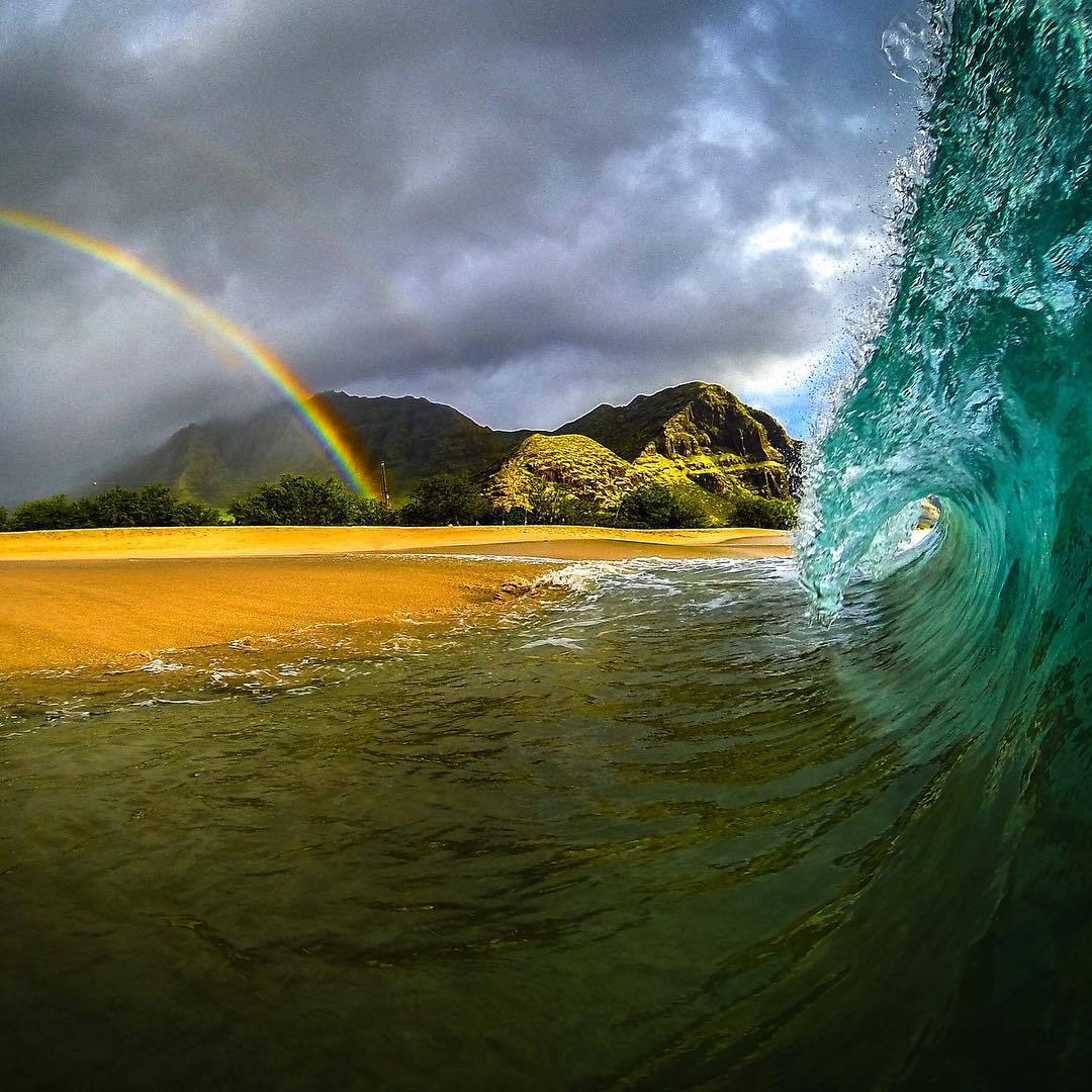
I have noticed a beautiful wave/rainbow picture on your website today. I taught myself to do high quality images to capture beauty of Hawaii, but I have never seen such a beautiful picture that conveys Hawaiian spirit so well. I am collecting canvas prints of such inspirational pictures I make on my wall. However, I doubt I will ever be able to capture such a beauty. Is it possible for you to share this picture? I would love to have it as a central piece in my collection.
Thanks for posting inspirational images. Now I will be trying to go into the waves every time I see a rainbow to capture the same picture 😉
Mahalo, Anna
~~~ Hi Anna, very nice to read your words, so supportive!
I’m delighted that you appreciate today’s picture, I totally agree…what a combo of weather and waves!
I love finding nice pictures to post, it inspires me both in the looking for…and the sharing of these images.
Very glad to know you are on Oahu, and finding my website useful!
Aloha, Glenn
woody adamz Says:
…..Lucky you going on hike….I gotta do a hike/camp trip myself soon as I love bring up mountain under the stars….I pretty much live outside as nature and quietude are and always have been my fav mode of existence….Yesterday was sunny here in Ainaloa with 20-25 knot circular winds..and,today is Rain….not too heavy but pretty steady…. Hi Mom and Hi Linda….Glad you are both on upswing…Having Glen “on deck” I’m sure is a blessing….Have a Great Day all…..AHHHHHHH..
~~~ Hi again Woody, yes, that hike into the Redwoods yesterday was fabulous…along with the small creek that ran through the groove.
I know what you mean about quietude, it’s my thing as well, keeps me grounded.
Glad you’re getting some rain down your way, totally sunny, dry, and warm here in northern California. The spring is so lovely in this part of the state!
Take care Woody,
Aloha, Glenn
Scott Says:
Hi Glenn,
I appreciate your work daily as I try to plan my day in the office and on the water here on Maui.
We have friends coming this week to kite, who have been scouring websites looking for wind. Our group has looked to you for advice for many years- we used to all get together early AM to watch you on TV before our day started! I’m glad I can still read the daily narratives. Thanks for keeping us up to date even though you are on the mainland. Your work affects a lot of people even though you may not know it. Just thought I’d let you know. Thanks again!
~~~ Hi Scott, so happy to hear that you used to enjoy my TV weather show for all those years…that was so much fun!
This website is great too, I enjoy keeping it updated all day everyday…It’s my life now, at least in terms of my work…in addition to keeping track of all the tropical cyclone activity across the planet. The Pacific Disaster Center fortunately told me that I can work from anywhere in the world!
Best wishes to your friends, hope they find some kiteboarding winds when they get here!
Best wishes friend…
Aloha, Glenn
Jeanette Says:
Hi Glenn,
I followed you regularly when I lived on Maui. A few years ago I moved to Sebastopol, but when I was homesick I would pull up your page. I’m back on Maui for a month to plan my return. Funny that you are now in the North Bay Area. And nice that you can still work and be there for your mom and friends. Be sure to catch the happenings at The Barlow and the Sunday morning farmer’s market.
Cheers!
Jeanette
~~~ Hi Jeanette, wow, you’re now on Maui…planning your return. We both love Maui and Marin and Sonoma Counties, we have that in common. I find these places to be my favorite, although I’m sure many other areas would be wonderful to be in too.
Best of luck with your return to Maui, I’ll never tire of getting back home to upper Kula…I love it.
I must admit however, Marin and Sonoma, and Mendocino are fabulous too!
I will definitely get to the Barlo, and I enjoy the Farmers Mkt too, right across from Whole Foods…where I shop when I’m in Sebastopol.
Best of luck to you!
Aloha, Glenn
Mauri Galvez Says:
1st time poster, but longtime reader/visitor of your site want to express appreciation for your helpful and beneficial efforts and wish you and your mom well.
23 yr Maui resident (from Silicon Valley area), living on the side of Haleakala now for 14+ years have come to depend on your site for weather info and forecasts.
You’re always more informative, and accurate, than any of the big weather or news sites. Much mahalo.
~~~ Hi Mauri, good to hear from you, thanks so much for your positive comments! I always enjoy reading encouraging words from my long time readers…and all readers for that matter.
My Mom reads all these comments, so she will be reading yours too, let me thank you, and all those kind folks who are following my Mom’s much better health.
Best to you…
Aloha, Glenn