


Air Temperatures – The following maximum temperatures (F) were recorded across the state of Hawaii Thursday along with the low temperatures Thursday:
86 – 77 Lihue, Kauai
87 – 75 Honolulu, Oahu
88 – 74 Molokai AP
90 – 67 Kahului AP, Maui – record high Thursday was 93
88 – 76 Kailua Kona
87 – 71 Hilo AP, Hawaii
Here are the latest 24-hour precipitation totals (in inches) for each of the islands as of Thursday evening:
0.27 Mount Waialeale, Kauai
0.28 Ahimanu Loop, Oahu
0.00 Molokai
0.00 Lanai
0.00 Kahoolawe
0.30 West Wailuaiki, Maui
0.33 Saddle Quarry, Big Island
The following numbers represent the strongest wind gusts (mph) as of Thursday evening:
21 Port Allen, Kauai
31 Oahu Forest NWR, Oahu
29 Molokai
28 Lanai
30 Kahoolawe
25 Maalaea Bay, Maui
30 Pali 2, Big Island
Hawaii’s Mountains – Here’s a link to the live webcam on the summit of our tallest mountain Mauna Kea (nearly 13,800 feet high) on the Big Island of Hawaii. This webcam is available during the daylight hours here in the islands, and at night whenever there’s a big moon shining down. Also, at night you will be able to see the stars — and the sunrise and sunset too — depending upon weather conditions.
Aloha Paragraphs

Cold front far northwest of Hawaii

The ragged leading edge of an early season cold front far to the northwest

High cirrus clouds moving away eastward

Showers mostly offshore, a few over the islands locally – Looping radar image
Small Craft Advisory…Maalaea Bay, Pailolo and Alenuihaha Channels, leeward and southeast waters of the Big Island
~~~ Hawaii Weather Narrative ~~~
The trade winds will persist in the moderately strong range through the weekend, into early next week. Here’s the latest weather map, showing a moderately strong, near 1023 millibar high pressure system far to the northeast of Hawaii. Our refreshing trade winds will remain in place through the next week, with no definite end in sight.
Here’s a wind profile of the offshore waters around the islands – A closer look
Here’s the Hawaiian Islands Sulfate Aerosol animated graphic, showing vog forecast
Fair weather will prevail through the rest of the week, with a chance of showers early next week. Our weather should remain quite pleasant through the weekend, with just a few windward showers at times. The models show some moisture arriving early next week, from a couple of possible sources. We may find some showers arriving from the southeast, as a tropical disturbance moves close to the Big Island next Tuesday. At about the same time, we could see some showers arriving from an old cold front, mostly over the Kauai end of the island chain.
Marine environment details: A small craft advisory (SCA) is in effect for the typical windier coastal waters around Maui County and the Big Island, due to the breezy trade winds. Winds are expected to decrease Friday morning, then strengthen again this weekend. The SCA will likely drop out Friday, and then be back over the weekend as the winds strengthen and a northwest swell arrives.
Surf along north and west facing shores will begin to build Friday night, and then peak over the weekend at advisory levels, as a large northwest swell reaches the islands. A similar sized northwest swell may follow Sunday night, peaking Monday into Tuesday.
Nice weather through the rest of the week
World-wide tropical cyclone activity..
Here is useful information about Hurricane Matthew:
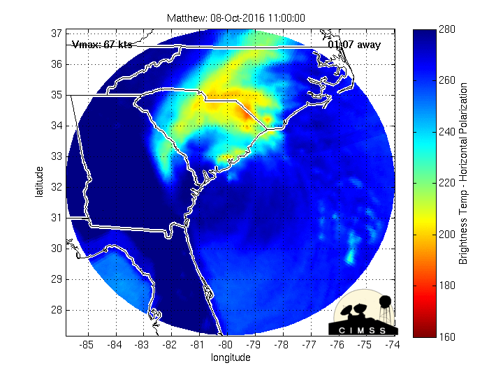
Hurricane 14L (Matthew) is an intense major category 3 hurricane (120 mph sustained winds)…brushing the Florida coast
Here’s the latest satellite image of this hurricane, with the looping version…and what the computer models are showing
NHC Tropical Storm Force Wind Speed Probability graphic
Looping radar image, showing hurricane Matthew moving through the Bahamas towards Florida / with a second radar loop showing Florida more directly
The Windytv wind profile of hurricane Matthew
The current wind speed and directions for areas around Florida
How strong Matthew is when it affects Georgia and South Carolina is difficult to predict, as it depends on how much time the hurricane spends over land in Florida.
![]()
>>> Atlantic Ocean:
Tropical Storm 15L (Nicole) is located approximately 335 miles south of Bermuda. Here’s the NHC graphical track map, a satellite image, and what the computer models are showing
Here’s a satellite image of the Atlantic Ocean
>>> Caribbean:
Hurricane 14L (Matthew) remains an extremely dangerous category 3 major hurricane! Located approximately 95 miles southeast of Jacksonville, Florida. Here’s the NHC graphical track map, a satellite image, and what the computer models are showing
>>> Gulf of Mexico: No active tropical cyclones
Here’s a satellite image of the Caribbean Sea…and the Gulf of Mexico
Here’s the link to the National Hurricane Center (NHC)
>>> Eastern Pacific: No active tropical cyclones
Here’s a wide satellite image that covers the entire area between Mexico, out through the central Pacific…to the International Dateline.
1.) An area of low pressure is expected to form several hundred miles south-southwest or southwest of the southern tip of the Baja California peninsula in a few days. Environmental conditions are expected to be conducive for development of this system, and a tropical depression could form by the early or middle part of next week. The low is expected to move generally west- northwestward at 10 to 15 mph.
* Formation chance through 48 hours…low…near 0 percent
* Formation chance through 5 days…medium…60 percent
2.) A second area of low pressure could develop several hundred miles south or southwest of the south-central coast of Mexico early next week. Some gradual development of this system is also possible while the low moves generally westward at about 10 mph.
* Formation chance through 48 hours…low…near 0 percent
* Formation chance through 5 days…low…20 percent
Here’s the link to the National Hurricane Center (NHC)
>>> Central Pacific: No active tropical cyclones
1.) A poorly organized area of showers and thunderstorms, located 940 miles southeast of the Big Island of Hawaii, is associated with a trough of low pressure. Development, if any, of this system will be slow to occur as it moves generally westward near 10 mph during the next several days.
* Formation chance through 48 hours…low…20 percent
Here’s a link to the Central Pacific Hurricane Center (CPHC)
Tropical Storm 22W (Aere) remains active, located approximately 127 NM east-southeast of Hong Kong. Here’s the JTWC graphical track map, a satellite image, and what the computers models are showing
>>> South Pacific Ocean: No active tropical cyclones
>>> North and South Indian Oceans / Arabian Sea: No active tropical cyclones
Here’s a link to the Joint Typhoon Warning Center (JTWC)
Interesting: Hydrogen-powered passenger ferry in San Francisco Bay is possible – Nearly two years ago, Sandia National Laboratories researchers Joe Pratt and Lennie Klebanoff set out to answer one not-so-simple question: Is it feasible to build and operate a high-speed passenger ferry solely powered by hydrogen fuel cells? The answer is yes.
The details behind that answer are in a recent report, “Feasibility of the SF-BREEZE: a Zero Emission, Hydrogen Fuel Cell High Speed Passenger Ferry.” SF-BREEZE stands for San Francisco Bay Renewable Energy Electric Vessel with Zero Emissions.
“The study found that it is technically possible to build a high-speed, zero-emission hydrogen-powered ferry. We also believe this can be done with full regulatory acceptance,” said Pratt.
“In the course of the study, we examined over 10 major issues where feasibility was initially unknown. SF-BREEZE sailed through them all,” added Klebanoff.
Tom Escher, president of San Francisco’s Red and White Fleet, first conceived of the project when he asked if it was possible to do away with emissions altogether on one of his ferries.
“This is a game changer. We can eliminate environmental pollution from ships,” he said. “This could have a major impact on every shipyard in the country.”
Funded by the Department of Transportation’s Maritime Administration and led by Sandia, the feasibility study brought together the American Bureau of Shipping (ABS), the U.S. Coast Guard, naval architect Elliott Bay Design Group, the Port of San Francisco and dozens of other contributors.
“Not long ago, the prospect of pollution-free transportation seemed like science fiction,” said Maritime Administration Administrator Paul “Chip” Jaenichen. “Today, through public-private collaboration on projects like SF-BREEZE, we are making progress to turn it into a reality.”
Novel boat design
Hydrogen-powered ferries do exist, but most are smaller, slower vessels used for tours on lakes and rivers. The SF-BREEZE study set out to discover whether it is technically feasible to build a large, fast vessel; it could meet maritime regulations; and it could be economically competitive with modes of transportation already available in the San Francisco Bay area.
The group drew up conceptual specifications: a 150-passenger commuter ferry that would travel four 50-mile round-trip routes each day at a top speed of 35 knots (roughly 39 miles per hour) about 60 percent of the time. The ferry could refuel midday, between the morning and afternoon commutes.
“This kind of boat has never been built before,” said mechanical engineer Curt Leffers, the project manager for Elliott Bay Design Group. “Hydrogen fuel cells are heavier than diesel engines for a given power output, so achieving the right power-to-weight ratio for the vessel was tricky.”
The need for speed drove the design to a slightly longer catamaran. The engineers were able to save weight by consolidating the support equipment for the fuel cells.
To achieve the necessary safety standoffs from the fuel cells, the designers placed the fuel cells on the main deck of the vessel in a separate compartment. Leffers explained that this provides physical separation between the fuel cells and passengers.
The project supports Elliott Bay’s commitment to the environment. “I’m a big believer in developing environmentally friendly designs,” Leffers added. “This project has been terrific because it’s something I really believe in. I think that this proof-of-concept, that this boat can be built, is very important for future projects.”
Regulations and economics
ABS issued a conditional Approval in Principal to verify that the conceptual design would be compliant with applicable regulations and rules and to identify any potential gaps in compliance. Combining their assessment with feedback from the U.S. Coast Guard, Sandia found no regulatory show-stoppers and concluded that the vessel will be acceptable from a regulatory perspective once a more detailed “ready-to-build” design is generated.
“ABS is proud to have participated in the SF-BREEZE feasibility study and advance the research on unique challenges of designing a high-speed passenger ferry powered solely by hydrogen fuel cells,” said ABS Chief Technology Officer Howard Fireman. “The collaboration with Sandia and the project team extends our knowledge base and the potential technology transfer to address the challenge of reducing the environmental footprint.”
The hydrogen ferry would cost about twice as much as a comparable diesel ferry with today’s prices. Much of that cost is in the fuel cell system.
“Right now, we can’t achieve economic parity with a comparable diesel ferry,” said Pratt. “But this is a question we need to explore further. Is economic parity necessary from the outset? Lessons from the automotive market tell us maybe not.”
Vehicle manufacturers have successfully brought fuel cell electric vehicles to market even though those cars are more expensive than comparable internal combustion engine vehicles. Many experts expect mass adoption of fuel cell electric vehicles to bring down prices of hydrogen fuel cells.
Optimization is next step
The next step is to optimize the vessel design. “We need to consider if the parameters we started out with are optimal for the technology that is available today,” said Pratt.
Working with Red and White Fleet and other stakeholders, Klebanoff and Pratt are now undertaking an optimization study. They will examine the tradeoffs between speed and costs and emissions among other factors.
Red and White Fleet President Escher sees SF-BREEZE as the start of a revolution in marine transportation. “When this boat is launched, it will be a seed. When you add a seed to water, it grows,” he said. “This seed could grow into a 40-meter tugboat, a 70-meter supply boat or a 300-meter oceangoing ship trading between the West Coast and Hawaii. And all at zero pollution.”
todd Says:
Hey Glenn I know the NHC has a monopoly on weather data, there is now way Matthew is a cat4. People are saying they were forced to hype the storm for political reasons concerning climate change. I was watching the weather channel and reporters were not ever seeing tropical storm force winds with the storm being directly off the cost 60 miles from the center of the storm. Makes you wonder. Regards-
~~~ Hi Todd, thanks for your comments, Aloha, Glenn
Christian Twigg-Smith Says:
What happened to the closer view?
~~~ Hi Christian, the information being shown on the product was incorrect, and I’m waiting to see when it gets fixed, and will re-instate it then.
Aloha, Glenn
Tim Says:
I just noticed that you were dropped from the online version of the Maui News. What happened?
~~~ Hi Tim, I wasn’t aware of this change. I just called the Publisher of the Maui News, and will ask him why. If I hear from him today, I’ll post his answer here.
Joe, the Publisher of the Maui News just called me, and he said my website will be back on their site tomorrow (Friday).
Thanks again for letting me know!
Aloha, Glenn
todd Says:
Hi Glenn, I’m not a hurricane expert but how can Matthew be a cat 4 the storm does not look organized and the eye is hardly visible. There are a lot of people asking the same questions. Regards-
~~~ Hi Todd, that’s a reasonable question, and part of the reason that the cloud signature looks a bit disorganized at the moment, is that it just banged through lots of Islands in the Caribbean, and is now getting moving through the Bahama’s…towards the Florida coast. Hurricanes don’t like land, they prefer the open ocean, and especially a warm to very warm ocean.
As far as it being a category 4 hurricane, well, if the National Hurricane Center says its that, I totally trust and believe it…they ARE the experts.
Aloha, Glenn
Eleanor Schofield Says:
RE: Your piece about new ferries for San Francisco Bay:
Hydrogen ferry between our islands? Wouldn’t that be nice…
Eleanor in (somewhat damp) Hilo
~~~ Hi Eleanor, it sure would be nice, not only in San Francisco, but also here in the islands, and everywhere! I assume that it’s just a matter of time.
Aloha, Glenn