


Air Temperatures – The following maximum temperatures (F) were recorded across the state of Hawaii Sunday…along with the low temperatures Sunday:
87 – 79 Lihue, Kauai
86 – 77 Honolulu, Oahu
85 – 77 Molokai AP
90 – 76 Kahului AP, Maui – record high Sunday was 94…back in 1953
89 – 77 Kona AP
85 – 73 Hilo AP, Hawaii
Here are the latest 24-hour precipitation totals (inches) for each of the islands…Sunday evening:
2.54 Mount Waialeale, Kauai
0.14 Punaluu Stream, Oahu
0.02 Molokai
0.00 Lanai
0.00 Kahoolawe
0.24 West Wailuaiki, Maui
2.09 Papaikou Well, Big Island
The following numbers represent the strongest wind gusts (mph)…Sunday evening:
32 Port Allen, Kauai
35 Oahu Forest NWR, Oahu
37 Molokai
32 Lanai
38 Kahoolawe
37 Maalaea Bay, Big Island
33 Pali 2, Big Island
Hawaii’s Mountains – Here’s a link to the live web cam on the summit of near 13,800 foot Mauna Kea on the Big Island of Hawaii. This web cam is available during the daylight hours here in the islands…and when there’s a big moon shining down during the night at times. Plus, during the nights you will be able to see stars, and the sunrise and sunset too…depending upon weather conditions.
Aloha Paragraphs

Normal trade wind weather…over these last few days of very late summer

Thunderstorms far south and west

Clear to partly cloudy…a large cloud patch along our windward sides locally

Showers mostly windward areas – Looping radar image
Small Craft Advisory…windiest coasts and channels Maui County and the Big Island
~~~ Hawaii Weather Narrative ~~~
Gusty trades…a little lighter as we push into the new week. Here’s the latest weather map, showing a moderately strong high pressure system to our north-northeast, with another similar cell far to our north. We can expect gusty trade winds through Wednesday. As we reach Thursday and Friday, we may see the trade winds diminish a bit in strength…as the old circulation of former tropical cyclone Orlene moves closer.
The recent moist and somewhat unstable atmospheric conditions…is now being replaced by a drier and increasingly stable air mass. As always though, when the trade winds are blowing, we’ll find showers carried towards our windward coasts and slopes. The leeward beaches should be in good shape, with generally fine weather conditions prevailing.
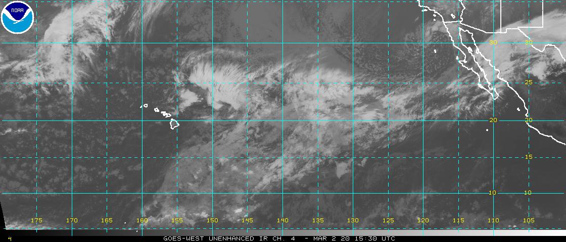
Looking ahead, we may see an increase in showers later in the week…as an area of tropical moisture gets carried towards us on the trade winds. This area is loosely associated with former TC Olene…and is located between our islands, and Hurricane Paine near Mexico. This area shows up faintly around 142W and 18N…look for it on this satellite image. Paine will stay in the eastern Pacific near Baja California by the way, and won’t be an issue for Hawaii. Although the folks in the dry southwest might get some localized heavy rainfall around Wednesday.
Here’s a wind profile…of the offshore waters around the islands – with a closer view
Here’s the Hawaiian Islands Sulfate Aerosol animated graphic – showing vog forecast
Marine environment details: A Small Craft Advisory (SCA) remains in effect for the typically windy waters around the Big Island and Maui County…due to locally strong easterly trade winds. The SCA is currently in effect through Monday afternoon, although may need to be extended into mid- week.
The current northwest swell will decline. No other significant northwest swells are expected through the week. Trade winds will maintain an easterly swell, followed by a decline during the week. South facing shores will see a small south-southwest swell…with a possible increase in swell energy Tuesday and Wednesday.
Friday Evening Film: All of my movie viewing friends or off the island now, so I’ll go see one alone this time. I’ve picked the new one called Snowden, starring Tom Wilkinson, Nicolas Cage, Joseph Gordon-Levitt, Shailene Woodley, Rhys Ifans, Timothy Olyphant, Joely Richardson and Melissa Leo…among others. The synopsis, Academy Award winning director Oliver Stone, who brought Platoon, Born on the Fourth of July, Wall Street and JFK to the big screen, tackles this fascinating true story. Snowden, the politically-charged, pulse-pounding thriller reveals the incredible untold personal story of Edward Snowden, the polarizing figure who exposed shocking illegal surveillance activities by the NSA…and became one of the most wanted men in the world. He is considered a hero by some, and a traitor by others. No matter which you believe, the epic story of why he did it, who he left behind, and how he pulled it off makes for one of the most compelling films of the year.
This was the opening night for Snowden, and it played in the largest theater of the megaplex. Many of the seats were taken, although it wasn’t by any means a packed house. The basic premise that I took away, if we’re to believe it, is that the Government is electronically spying on us at every turn. This computer spying appeared, at least in the film, to be rampant across our country. The audience is asked to contemplate some very serious questions. This wasn’t my favorite film of the year, although I will say that it was very thought provoking. I enjoyed it quite a lot, and in the end am giving it a B+ grade. It was interesting that I’d say about half the people in the theater clapped out loud at the end of the film…I don’t see this happening much! If you have any interest, here’s the trailer – large screen viewing is good.
Pleasant conditions…as we glide tranquilly towards Autumn 2016 – Thursday, September 22nd
World-wide tropical cyclone activity…
![]()
>>> Atlantic Ocean:
Tropical Storm 12L (Karl) remains active, located approximately 895 miles east of the Leeward Islands. Here’s the NHC graphical track map, a satellite image…and what the computer models are showing
1.) Shower and thunderstorm activity associated with a large but well-defined low pressure system located southwest of the Cabo Verde Islands is beginning to show signs of organization. Environmental conditions are expected to be conducive for development over the next couple of days, and a tropical depression is likely to form later today or on Tuesday before large-scale conditions become less favorable. Occasional heavy rains and gusty winds associated with this system should diminish later today over the Cabo Verde Islands.
Invest 96L, satellite image…and the computer model outlooks
* Formation chance through 48 hours…high…70 percent
* Formation chance through 5 days…high…80 percent
Here’s a satellite image of the Atlantic Ocean
>>> Caribbean: No active tropical cyclones
>>> Gulf of Mexico: No active tropical cyclones
Here’s a satellite image of the Caribbean Sea…and the Gulf of Mexico
Here’s the link to the National Hurricane Center (NHC)
>>> Eastern Pacific:
Hurricane 17E (Paine) remains active, located approximately 355 miles west of the southern tip of Baja California. Here’s the NHC graphical track map, a satellite image…and what the computer models are showing
1.) An area of low pressure could form in a couple of days well to the southwest of southwestern Mexico. Development, if any, of this system should be slow to occur while it moves slowly northwestward.
* Formation chance through 48 hours…low…near 0 percent
* Formation chance through 5 days…low…20 percent
Here’s a wide satellite image that covers the entire area between Mexico, out through the central Pacific…to the International Dateline.
Here’s the link to the National Hurricane Center (NHC)
>>> Central Pacific: No active tropical cyclones
Here’s a link to the Central Pacific Hurricane Center (CPHC)
Typhoon 18W (Malakas) remains active…located approximately 132 NM south of Sasebo, Japan. Here’s the JTWC graphical track map … a satellite image … and what the computer models are showing
>>> South Pacific Ocean: No active tropical cyclones
>>> North and South Indian Oceans / Arabian Sea: No active tropical cyclones
Here’s a link to the Joint Typhoon Warning Center (JTWC)
Interesting: Virgin Atlantic: Emissions from Steel Mills Could Fuel Airplanes – After five years of research and development, Virgin Atlantic and one of its clean-technology partners, Illinois-based LanzaTech, developed a source of jet fuel made of waste gases from steel mills. According to the companies, this new source of jet fuel passed extensive tests that both delivered on performance and promise to result in carbon emissions savings of 65 percent compared to conventional jet fuel.
This discovery comes at a time when airlines, seeking to mitigate what is a carbon-intensive business, have long dabbled with jet fuel blended with algae and other biofuels. The Dutch carrier KLM experimented with algae fuel blends, has flown transatlantic flights using blends of kerosene and cooking oil, and is still apparently committed to sourcing these fuels when available. Alaska Airlines also considered using recycled cooking oil to reduce its carbon emissions. Earlier this year, United kicked off flights between San Francisco and Los Angeles using a biofuel-conventional blend. Aviation fuel using feedstock from Brazilian sugarcane is also touted as an option.
But the problem with the development of more sustainable jet fuel boils down to one word: scale. A blend of 5, 10 or even 50 percent sounds impressive. But airlines are still struggling to get a seat on the carbon-reduction bandwagon – and air travel is still on the rise worldwide. The struggle with expanding capacity for fuels such as algae-based oils is one reason why one giant in the industry, Solazyme, transitioned away from a focus on biofuels, rebranded itself as TerraVia, and now sees foods made from algae as its cash cow.
Virgin Atlantic and LanzaTech suggest they have a more scaleable option. LanzaTech’s process involves capturing carbon monoxide gas from steel mills and other carbon-intensive industries. That carbon monoxide is then collected and fermented into alcohol, which can eventually be transformed into ethanol feedstock. The companies say each gallon of that ethanol can be converted into a half gallon of jet fuel, while reducing emissions from steel mills by up to a third.
Some say this does not really solve the carbon emissions problem, as emissions from one dirty industry are simply collected and burned off by another. But LanzaTech estimates that 15 billion gallons of jet fuel could be produced should this technology scale, enough to meet almost 20 percent of the global aviation industry’s fuel requirements.
The first phase generated 1,500 gallons of jet fuel. To put those numbers in context, a Boeing 747 consumes 1 gallon of fuel per second. (Do the math and compare airplane vs. automobile mileage, and you could argue that flying by air is more efficient than driving by car given the number of passengers.) So, we are still left with that pesky question of scale, as this is only enough fuel to fly a puddle jumper from a Central Valley town to a larger California air hub.
Nevertheless, innovation by the likes of Virgin Atlantic and LanzaTech is more than just being “sustainable” or wowing stakeholders. This is another step as scientists and entrepreneurs find ways to create fuel that has is more efficient and with a reduced impact on the planet.
j. eagle Says:
Glenn,
Huge thanks for movie critiques from a fan who used to take the train from Aberdeen, MD to NYC, to see two flicks in a day. Your review of “Snowden” thoughtfully provided snither reason not to see it. Though finding two movies worth attending in a day might be hard, am always up for one.
Mahalo.
J. (Also your devoted fan)
~~~ Hi J, good to hear from you. I’m with you, I love a good film, and haven’t very many times in my life, although could see two good ones if I had the time and inclination…you bet!
Thanks for being a devoted reader of my website, I appreciate your letting me know!
Aloha, Glenn