


Air Temperatures – The following maximum temperatures (F) were recorded across the state of Hawaii Wednesday…along with the low temperatures Wednesday:
82 – 75 Lihue, Kauai
89 – 78 Honolulu, Oahu
91 – 77 Molokai AP
91 – 73 Kahului AP, Maui – record 94…back in 1953
88 – 78 Kona AP
86 – 72 Hilo AP, Hawaii
Here are the latest 24-hour precipitation totals (inches) for each of the islands…Wednesday:
2.57 Mount Waialeale, Kauai
1.93 Poamoho RG 1, Oahu
0.05 Puu Alii, Molokai
0.00 Lanai
0.01 Kahoolawe
1.01 West Wailuaiki, Maui
1.65 Ahumoa, Big Island
The following numbers represent the strongest wind gusts (mph)…Wednesday:
24 Puu Lua, Kauai
38 Oahu Forest NWR, Oahu
27 Molokai
32 Lanai
28 Kahoolawe
20 Kahului AP, Maui
27 Pali 2, Big Island
Hawaii’s Mountains – Here’s a link to the live web cam on the summit of near 13,800 foot Mauna Kea on the Big Island of Hawaii. This web cam is available during the daylight hours here in the islands…and when there’s a big moon shining down during the night at times. Plus, during the nights you will be able to see stars, and the sunrise and sunset too…depending upon weather conditions.
Aloha Paragraphs

Darby is spinning to the east of Hawaii, with Estelle following in Darby’s wake…along with former Celia moving away northwest of Kauai

Darby spinning towards the Hawaiian Islands, with an expected turn towards the northwest just before reaching us…probably

Darby in our central Pacific…as a tropical storm
![]()
What the models show for Darby

Estelle heading into higher latitudes…not a threat for Hawaii

Estelle peaking in strength…remaining a tropical storm for several days
![]()
What the models are showing for Estelle

We see former Celia, with associated thunderstorms moving away to our northwest…with Darby spinning in the direction of Hawaii

Showers locally – Looping radar image
Small Craft Advisory…windiest coasts and channels around Maui County and the Big Island
~~~ Hawaii Weather Narrative ~~~
Refreshing trades returning through Friday…then lighter winds with more muggy air arriving by the weekend. Here’s the latest weather map, showing a very strong near 1040 millibar high pressure system in the area far north of Hawaii. At the same time, we see former tropical depression Celia moving away well to the northwest of our islands…steadily westward. Relatively cooler and more refreshing trade winds will return for a couple of days, becoming quite breezy. We’ll then see more muggy air arriving…as whatever is left of tropical cyclone Darby likely moves by just to the northeast and north of the state, through the weekend into early next week. There’s a chance that Darby could not take a turn towards the northwest, in which case our winds could increase markedly rather than soften…stay tuned.
Here’s a wind profile…of the offshore waters around the islands – with a closer view
Here’s the Hawaiian Islands Sulfate Aerosol animated graphic – showing vog forecast
We’re moving back into a typical trade wind weather pattern for the time being…with a few showers. As the trade winds return now, we’ll see our showers focusing on the windward sides…for the most part at least. The leeward beaches should be quite nice, with generally dry weather prevailing. Meanwhile, as tropical storm Darby gets closer to Hawaii by the weekend, we could see this system bringing a weather change our way. There continues to be a spread in what the computer models are suggesting, so there’s still uncertainty about the eventual track for Darby, and associated weather conditions as it nears Hawaii. It should be pointed out that the islands, and especially the eastern islands in the chain, could see tropical storm conditions…stay tuned.
Marine environment details: A Small Craft Advisory is currently posted for the typically windy waters around Maui County and the Big Island as strong high pressure builds in to our north. Expect these conditions to continue for the next few days. Later in the week swells from Tropical Storm Darby along with locally generated wind waves will likely cause Small Craft Advisory conditions over waters exposed to these swells. Also, depending on the track and intensity of Darby, winds and seas may increase over the eastern coastal waters this weekend.
Swells from Tropical Storm Darby will cause an increase in surf along east facing shores later this week and on through the weekend. Advisory level surf is likely over the eastern islands as early as Thursday, gradually spreading up the island chain Thursday night and Friday. Depending on the strength and intensity of Darby, surf heights could approach warning levels during the peak of the swell. Otherwise there will be a series of small southerly swells through the rest of the week and on through the weekend.

Trade wind weather pattern
World-wide tropical cyclone activity –
>>> Atlantic Ocean: No active tropical cyclones
Tropical cyclone formation is not expected during the next 5 days
Here’s a satellite image of the Atlantic Ocean
>>> Caribbean Sea: No active tropical cyclones
Tropical cyclone formation is not expected during the next 5 days
>>> Gulf of Mexico: No active tropical cyclones
Here’s a satellite image of the Caribbean Sea…and the Gulf of Mexico
Here’s the link to the National Hurricane Center (NHC)
>>> Eastern Pacific:
Estelle remains active well offshore from Mexico…located about 1115 west of the southern tip of Baja California. Here’s the NHC graphical track map, along with a satellite image of this area…and the computer models are showing.
1.) Showers and thunderstorms have increased in organization since yesterday in association with a broad area of low pressure located several hundred miles south-southwest of Acapulco, Mexico. Environmental conditions are expected to be conducive for further development of this system, and a tropical depression is likely to form during the next couple of days while it moves generally northwestward at about 10 mph to the south of Mexico.
* Formation chance through 48 hours…high…70 percent
* Formation chance through 5 days…high…90 percent
2.) Shower and thunderstorm activity continues to show signs of organization in association with an area of low pressure located about 900 miles south-southwest of the southern tip of the Baja California peninsula. Environmental conditions are forecast to be marginally conducive for some development of this system, and a tropical depression could form during the next few days while it moves west-northwestward at 10 to 15 mph.
* Formation chance through 48 hours…medium…40 percent
* Formation chance through 5 days…medium…60 percent
Here’s a wide satellite image that covers the entire area between Mexico, out through the central Pacific…to the International Dateline.
Here’s the link to the National Hurricane Center (NHC)
>>> Central Pacific:
Darby continues to move westward…located about 735 miles east of Hilo, Hawaii. Here’s the CPHC graphical track map, along with a satellite image of this area…and the computer models are showing.
Here’s a link to the Central Pacific Hurricane Center (CPHC)
>>> South Pacific Ocean: No active tropical cyclones
>>> North and South Indian Oceans / Arabian Sea: No active tropical cyclones
Here’s a link to the Joint Typhoon Warning Center (JTWC)
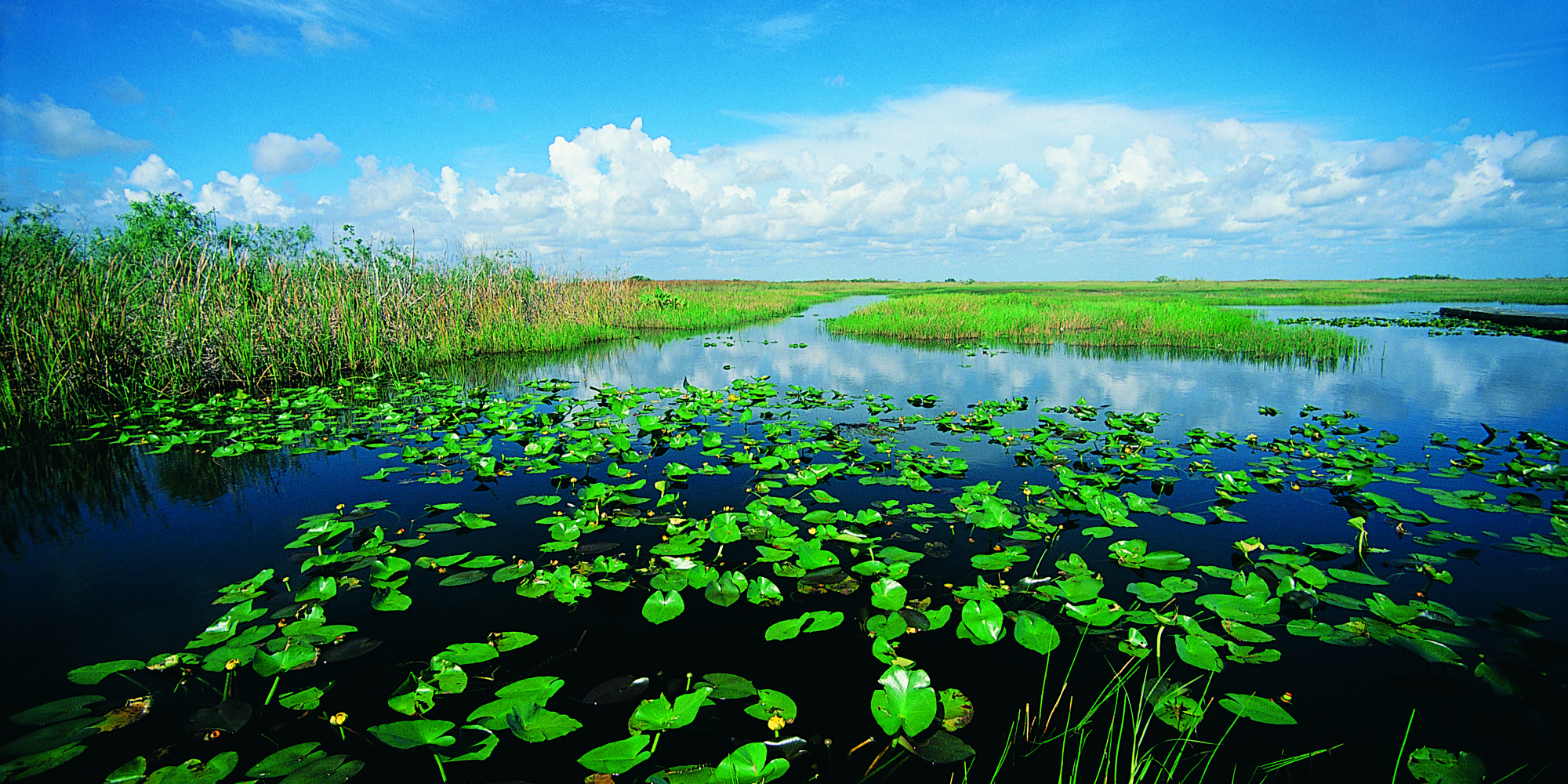
Interesting: Rising Seas Push Too Much Salt Into The Florida Everglades – The Florida Everglades is a swampy wilderness the size of Delaware. In some places along the road in southern Florida, it looks like tall saw grass to the horizon, a prairie punctuated with a few twisted cypress trees. The sky is the palest blue.
But beneath the surface a different story is unfolding. Because of climate change and sea level rise, the ocean is starting to seep into the swampland. If the invasion grows worse, it could drastically change the Everglades, and a way of life for millions of residents in South Florida.
An experiment is going on here to help scientists understand more about what’s likely to happen as the ocean invades. “We’re making, basically, artificial seawater here,” a guy wearing a mosquito net over his face tells me, as he stirs water in a vat the size of a hot tub.
The guy in the mosquito net is Joe Stachelek — a collaborator with Tiffany Troxler, from Florida International University. They’re making salt water and pumping it out into the wetland — dosing the plants and soil with their briny mix as a preview of what the ocean could do.
“As sea level rises,” Troxler explains, “the saltwater wedge moves inland.” And it infiltrates the bedrock.
“Our underlying rock is limestone,” Troxler says. “That limestone is very porous; it’s almost like Swiss cheese in some areas.”
We walk out into the test site — through the saw grass and the underlying peat, which is a fancy name for muck. It’s rich stuff, full of nutrients and microorganisms that feed this river of grass. And, like the plants, the peat also is affected by salt water.
The team has laid out a metal boardwalk, so you can walk around the muck without sinking up to your waist. Out here the grass is patchier, and in some places the peat is slumping — collapsing.
Troxler says there’s lots of this slumping going on. “When we start to lose the structure of the plants,” she explains, “essentially this peat, which is otherwise held together by roots, becomes a soupy pond.”
In response to the salt, the plants actually pull up some of their roots — out of the peat. The roots look like teeth protruding from receding gums.
This could be the future of the Everglades, Troxler says. And here’s the thing: The Everglades acts like sponge, feeding off the Biscayne aquifer — a giant cell of freshwater that lies underneath the land.
“We get over 90 percent of our freshwater from the Biscayne aquifer,” Troxler says, “we” meaning millions of people in South Florida.
As seawater seeps up from underneath, through the limestone bedrock, it is contaminating the aquifer and the Everglades above it.
That’s starting to worry some people. Like Julie Hill-Gabriel, who directs Everglades policy for the National Audubon Society in Florida. She says she tells people in South Florida, “What we do in the Everglades is 100 percent going to affect you in your neighborhood — [and whether] when you turn on the tap water, you have enough fresh clean water.”
For millennia, fresh water flowed south to the Everglades, making it the largest flooded grassland in America. But over the past several decades, that water was diverted to irrigate agricultural fields, and to keep homes from flooding. Environmental groups like Audubon have been trying to restore the natural flow to the Everglades, mostly to preserve wildlife.
Now, Hill-Gabriel says, there’s a new reason for that restoration — to repel the invading sea. Putting more freshwater back into the sponge that is the Everglades could create a kind of “back pressure” to keep seawater out.
“It just really compounds the urgency to move that freshwater south,” says Hill-Gabriel.
At least that’s the theory.
When it comes to climate change in South Florida, much of the focus until now has been about protecting property with pumps and barriers. But James Cason, the Republican mayor of the city of Coral Gables, says he hopes his constituents can understand the importance of protecting the Everglades as well.
“It’s not just so they can see the alligators,” Cason says. “It’s because they’ll want to make sure the drinking water on which we all depend is not contaminated.”