


Air Temperatures – The following maximum temperatures (F) were recorded across the state of Hawaii Wednesday…along with the minimums Wednesday:
79 – 69 Lihue, Kauai
80 – 69 Honolulu, Oahu
76 – 67 Molokai AP
81 – 68 Kahului AP, Maui
76 – 66 Hilo AP, Hawaii
Here are the latest 24-hour precipitation totals (inches) for each of the islands, as of Wednesday evening:
1.59 Kilohana, Kauai
1.10 Makaha Stream, Oahu
5.44 Puu Alii, Molokai
0.78 Lanai
0.05 Kahoolawe
3.65 Puu Kukui, Maui
2.20 Kawainui Stream, Big Island
The following numbers represent the strongest wind gusts (mph)…as of Wednesday evening:
29 Port Allen, Kauai – NE
42 Kuaokala, Oahu – NE
32 Molokai – ENE
40 Lanai – NE
35 Kahaloowe – NNW
29 Kaupo Gap, Maui – NW
44 Kohala Ranch, Big Island – NE
Hawaii’s Mountains – Here’s a link to the live web cam on the summit of near 13,800 foot Mauna Kea on the Big Island of Hawaii. This web cam is available during the daylight hours here in the islands…and when there’s a big moon shining down during the night at times. Plus, during the nights you will be able to see stars, and the sunrise and sunset too… depending upon weather conditions.
Aloha Paragraphs

Pacific storm track remains far north of Hawaii

A weakening cold front is gradually dissipating as it sits
over the Big Island

Lots of low level clouds to the north of the islands, arriving
over the windward sides…thanks to the gusty trade winds

Showers locally…generally falling along the windward sides
looping radar image
Small Craft Advisory…all coasts and channels statewide
High Surf Advisory…east facing shores through 6pm today
Wind Advisory…windiest areas in Maui County and the Big Island
20-30 mph with gusts to 50 mph
~~~ Hawaii Weather Narrative ~~~
Strong and gusty trade winds through Thursday…with lighter winds Friday into the weekend. Here’s the latest weather map, showing the Hawaiian Islands, and the rest of the North Pacific Ocean. We find a strong high pressure system northwest of Hawaii, with an associated ridge extending eastward to the north of the islands. In addition, there’s a low pressure system far to the northeast of Hawaii. The tail-end of a dissipating cold front is over the Big Island. As this cold front slowly moves offshore over the ocean, northeasterly winds will remain over the state…locally strong and gusty. These winds should taper off Friday, and then become much lighter ahead of another cold front approaching the islands during the weekend, along with more volcanic haze locally then. Our winds will turn cooler from the north early next week, in the wake of the weekend cold front…followed by light breezes into next Wednesday.
Here’s a wind profile…of the offshore waters around the islands – with a closer view
Here’s the Hawaiian Islands Sulfate Aerosol…animated graphic – showing vog forecast
Moisture from the recent frontal boundary is still around tonight, in addition to considerable clouds to our north through northeast…keeping windward showers in the forecast. The bulk of these showers will fall along the windward coasts and slopes. The leeward sides, and especially the beaches, should have better weather, albeit with occasional showers being carried over to those areas on the strong and gusty trade winds. The computer models continue pointing towards drier conditions returning to the state as we get into Friday. Showers may increase again as another cold front approaches the islands this coming weekend. I was just looking at the latest model runs, and they show a large area of moisture moving by to the north and northeast of the state later this weekend…which for the most part misses the state. Somewhat cooler and generally dry weather will arrive early next week for several days.
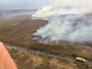
Here in Maui County…It’s mostly clear over the leeward sides early this Wednesday morning, with clouds and showers along the windward sides. Here in upcountry Kula we have an air temperature of 56.3F degrees well before sunrise. The temperature at near the same time was 68 degrees down in Kahului with light rain, 70 out in Hana…and 41 atop the Haleakala Crater. Meanwhile, Kahoolawe was 68 degrees, 64 at Lanai City, with 69 at the Molokai airport. / Just back from my morning walk, and saw lots of big bright rainbows! As I got up a bit higher, I could see what looks like haze over towards Keokea, and down into Kihei and Wailea. There are showers towards the north and up the mountain to the northeast from here in Kula too. There’s just a little bit of mist here at my place…and the winds are very light at the time of this writing. I just now see that there’s a 5,500+ acre brush fire here on Maui, which is bringing smoke to some areas…that’s the haze I see down towards the south, the south side of the island! In some areas the fire has burned all the way to the ocean below the highway, and to about the 3,500 foot level on the mountain side of the Piilani Highway. Here’s a picture taken yesterday.
– Mid-afternoon, under clear to partly cloudy skies, although with more cloudiness along the windward sides. The winds are still up, although have probably peaked yesterday, and will be on their way down through the rest of the week. The active showers earlier in the day seem to have been backing off now too. As I do most days, in between my early work and the work I do later in the afternoon into early evening, I went up the mountain from here in Kula…my backyard. I knew it was going to be raining, like it did yesterday while I was up there. Therefore, I took my rain equipment, and did some good walking outside, rather than skateboarding. Skateboarding and wet roads don’t go together, which is probably obvious. At any rate, I took the short nature trail hike in Hosmer’s Grove, and as it was lightly raining, there was no one around, which was kind of nice. I have about another 30 minutes before I start working again, so I think I’ll take it easy until then. I have a little piece of what’s called Princess Cake that I got at Mana Foods this past weekend. I like to eat just a little piece each day around 4pm, at the same time I have my regular shot of espresso. I sometimes buy a couple of cream puffs, which last me during the work week…they are so good!
– Early evening, just before sunset, and there continues to be a big difference between the cloudy, and off and on showery windward sides…and the dry leeward sides. I expect this to continue into Thursday, as the trade winds remain quite strong and gusty…carrying showers to those windward coasts and slopes.
I’ll be back with many more updates on all of the above and below, I hope you have a great Wednesday night wherever you’re spending it! Aloha for now…Glenn
World-wide tropical cyclone activity:
>>> Atlantic Ocean: The last regularly scheduled Tropical Weather Outlook of the 2015 Atlantic hurricane season…has occurred. Routine issuance of the Tropical Weather Outlook will resume on June 1, 2016. During the off-season, Special Tropical Weather Outlooks will be issued if conditions warrant. Here’s the 2015 hurricane season summary
Here’s a satellite image of the Atlantic Ocean
>>> Caribbean Sea: The last regularly scheduled Tropical Weather Outlook of the 2015 Atlantic hurricane season…has occurred. Routine issuance of the Tropical Weather Outlook will resume on June 1, 2016. During the off-season, Special Tropical Weather Outlooks will be issued if conditions warrant.
>>> Gulf of Mexico: The last regularly scheduled Tropical Weather Outlook of the 2015 Atlantic hurricane season…has occurred. Routine issuance of the Tropical Weather Outlook will resume on June 1, 2016. During the off-season, Special Tropical Weather Outlooks will be issued if conditions warrant.
Here’s a satellite image of the Caribbean Sea…and the Gulf of Mexico
Here’s the link to the National Hurricane Center (NHC)
>>> Eastern Pacific: The last regularly scheduled Tropical Weather Outlook of the 2015 North Pacific hurricane season…has occurred. Routine issuance of the Tropical Weather Outlook will resume on May 15, 2016. During the off-season, Special Tropical Weather Outlooks will be issued if conditions warrant. Here’s the 2015 hurricane season summary
Here’s a wide satellite image that covers the entire area between Mexico, out through the central Pacific…to the International Dateline.
Here’s the link to the National Hurricane Center (NHC)
>>> Central Pacific: The central north Pacific hurricane season has officially ended. Routine issuance of the tropical weather outlook will resume on June 1, 2016. During the off-season, special tropical weather outlooks will be issued if conditions warrant. Here’s the 2015 hurricane season summary
Here’s a link to the Central Pacific Hurricane Center (CPHC)
>>> South Pacific Ocean:
Tropical Cyclone 11P (Winston) remains active in the Southwest Pacific Ocean, located 182 NM northwest of Niue, with sustained winds of 115 mph. Here’s the JTWC graphical track map, along with a satellite image of this system…and what the computer models are showing
>>> North and South Indian Oceans / Arabian Sea:
Tropical Cyclone 13S (Uriah) remains active in the South Indian Ocean, located 963 NM south-southeast of Diego Garcia, with sustained winds of 104 mph. Here’s the JTWC graphical track map, along with a satellite image of this system…and what the computer models are showing
Here’s a link to the Joint Typhoon Warning Center (JTWC)
Interesting: Better water management could halve the global food gap – Improved agricultural water management could halve the global food gap by 2050 and buffer some of the harmful climate change effects on crop yields. For the first time, scientists investigated systematically the worldwide potential to produce more food with the same amount of water by optimizing rain use and irrigation. They found the potential has previously been underestimated. Investing in crop water management could substantially reduce hunger while at the same time making up for population growth. However, putting the findings into practice would require specific local solutions, which remains a challenge.
“Smart water use can boost agricultural production — we’ve in fact been surprised to see such sizeable effects at the global level,” says lead-author Jonas Jägermeyr from the Potsdam Institute for Climate Impact Research. In a water management scenario the scientists call ambitious, global kilocalorie production could rise by 40 percent, while according to UN estimates roughly 80 percent would be needed to eradicate hunger by the middle of this century. But even in less ambitious scenarios, results show that integrated crop water management could make a crucial contribution to filling the plates of the poor, says Jägermeyr. “It turns out that crop water management is a largely underrated approach to reduce undernourishment and increase climate resilience of smallholders.”
Large yield increase potential in China, Mexico, Australia
The scientists have run comprehensive biophysical computer simulations, constraining these in such a way that croplands do not expand into forests and no additional water resources are needed. As it is a global study, it provides detailed vegetation dynamics and water use effects in river basins — certainly too coarse to simulate farm-level conditions but suited to identify regional hotspots. For example, the yield increase potential of crop water management is found to be particularly large in water-scarce regions such as in China, Australia, the western US, Mexico, and South Africa.
“Assessing the potential is tricky: If upstream farmers reroute otherwise wasted water to increase irrigation and production, less water returns to downstream users and consequently this can affect their production,” says co-author and team leader Dieter Gerten. “Below the line, we found that the overall production increases. Still, this of course poses quite some distributional challenges. Also, a lot of local government regulation and incentives such as-micro credit schemes are needed to put crop water management into large-scale practice.”
Mulching and drip systems to counter climate change impacts
The scientists took into account a number of very different concrete water management options, from low-tech solutions for smallholders to the industrial scale. Water harvesting by collecting excess rain run-off for instance in cisterns — for supplementary irrigation during dry spells — is a common traditional approach in some regions such as the Sahel region in Africa, but is under-used in many other semi-arid regions such as Asia and North America. Mulching is another option — the soil gets covered either simply with crop residues left on the field, reducing evaporation, or with huge plastic sheets. Finally, a major contribution to the global potential is upgrading irrigation to drip systems.
It is especially under ongoing climate change that water management becomes increasingly important to reduce food risks. The reason is that global warming is likely to increase droughts and change rainfall patterns, so water availability becomes even more critical than before. Assuming a moderate CO2 fertilization effect — plants take up CO2 and could hence benefit from higher concentrations in the air, but the magnitude of this effect is still under debate -, the study shows that in most climate policy scenarios water management can counterbalance a large part of the regional warming impacts on farming. Yet if greenhouse-gas emissions from burning fossil fuels are not reduced at all, in a business-as-usual scenario, water management will clearly not suffice to outweigh the negative climate effects.
Given the planetary boundaries, decision-makers should look into water use
“Water management is key for tackling the greater sustainability challenge,” says Wolfgang Lucht, co-author of the study and co-chair of PIK’s research domain Earth System Analysis. “It has been an issue in many local and regional studies and its effects on farm level have been well demonstrated, but on the global level it has been somewhat neglected. The renewed Sustainable Development Goals — while stipulating sustainable agriculture among all nations — need to be based on more evidence on how to achieve it; they do not focus on water use very much. Since we’re rapidly approaching planetary boundaries, our study should indeed draw the attention of decision-makers of all levels to the potential of integrated crop water management.”
Maxine Says:
Awesome Glenn, thanks!
Edmonton has been fairly warm this winter and not much snow. Average +10 so pretty good for here. Still can’t wait for the hot sun and sand, Have a great day!
Maxine
~~~ Hi again Maxine, you’re very welcome, yes…that hot sun and sand will be here waiting for your return!
Aloha, Glenn
Maxine Says:
Morning Glenn, we are coming up from Canada on Sun. Whenever we come up I always check in with your updates. Miss you talking about your day and daily walks. Brought us right there with you even though there is snow here.
Looks like there is alot of wind, hopefully that dies down for a bit while we are there for the two weeks. Still better than snow. Love your site, keep up the good work.
Maxine
~~~ Hi Maxine, nice to hear from you up there in cold Canada. I still write about my daily events, although you’re accessing my site in the morning, and I haven’t done anything yet…still working!
At any rate, the windy weather we’re having now will be gone by the time you arrive this weekend. Looking ahead, it appears that you have chosen a good time to arrive. It will be way warmer here in Hawaii, than the snowy reality you will be leaving behind.
Here’s wishing you a lovely vacation, full of fun and sun, and all the things you like about flying down here to paradise!
Aloha, Glenn
Joy Says:
Thanks Glenn for the weather updates! I always check your website first. Have a great week! Joy
~~~ Hi, you are very welcome Joy, I appreciate your taking a minute to let me know…it’s always nice to get some positive feedback for the time and energy I put into keeping this website going!
Aloha, Glenn