


January 19-20, 2011
Air Temperatures – The following maximum temperatures were recorded across the state of Hawaii Wednesday afternoon:
Lihue airport, Kauai – 81
Honolulu airport, Oahu – 80
Kaneohe, Oahu – 77
Molokai airport – 75
Kahului airport, Maui – 76
Kona airport – 76
Hilo airport, Hawaii – 73
Air Temperatures ranged between these warmest and coolest spots near sea level – and on the highest mountain tops…as of 5pm Wednesday evening:
Honolulu, Oahu – 77F
Molokai airport – 71
Haleakala Crater – missing (near 10,000 feet on Maui)
Mauna Kea summit – 25 (near 14,000 feet on the Big Island)
Precipitation Totals – The following numbers represent the largest precipitation totals (inches) during the last 24 hours on each of the major islands, as of Wednesday evening:
0.05 Mohihi Crossing, Kauai
0.08 Punaluu Stream, Oahu
0.00 Molokai
0.00 Lanai
0.04 Kahoolawe
0.84 West Wailuaiki, Maui
1.99 Laupahoehoe, Big Island
Marine Winds – Here’s the latest (automatically updated) weather map showing a 1032 millibar high pressure system far to our northeast…with a high pressure ridge just to the north. At the same time, there are one or two troughs of low pressure in our area as well, which are keeping the trade winds at bay for the time being. Our winds will be gradually picking up from the trade wind direction Thursday into Friday.
Satellite and Radar Images: To view the cloud conditions we have here in Hawaii, please use the following satellite links, starting off with this Infrared Satellite Image of the islands to see all the clouds around during the day and night. This next image is one that gives close images of the islands only during the daytime hours, and is referred to as a Close-up visible image. This next image shows a larger view of the Pacific…giving perspective to the wider ranging cloud patterns in the Pacific Ocean. Finally, here's a Looping IR satellite image, making viewable the clouds around the islands 24 hours a day. To help you keep track of where any showers may be around the islands, here’s the latest animated radar image.
Hawaii’s Mountains – Here’s a link to the live web cam on the summit of near 14,000 foot Mauna Kea on the Big Island of Hawaii. The tallest peak on the island of Maui is the Haleakala Crater, which is near 10,000 feet in elevation. These two web cams are available during the daylight hours here in the islands…and when there’s a big moon rising just after sunset for an hour or two! Plus, during the nights and early mornings you will be able to see stars, and the sunrise too…depending upon weather conditions.
Tropical Cyclone activity in the eastern and central Pacific – Here’s the latest weather information coming out of the National Hurricane Center, covering the eastern north Pacific. You can find the latest tropical cyclone information for the central north Pacific (where Hawaii is located) by clicking on this link to the Central Pacific Hurricane Center. Here’s a tracking map covering both the eastern and central Pacific Ocean. A satellite image, which shows the entire ocean area between Hawaii and the Mexican coast…can be found here. Of course, as we know, our hurricane season won't end until November 31st here in the central Pacific.
Aloha Paragraphs
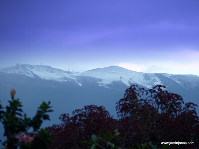
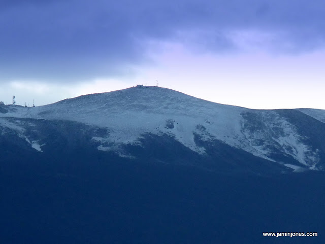
>Pictures of snow atop the Haleakala Crater, Maui…Wednesday morning!<
Winds will become trade winds Thursday into the weekend. These trades will continue likely right on into early next week….although softer by Monday into Tuesday. This weather map shows a moderately strong 1032 millibar high pressure system far to our northeast, with its associated ridge of high pressure (orange zigzag line) extending southwest, just barely to the north of the islands. As the cold front to our north and northwest moves away…it will take away its wind diminishing influence, with light to moderately strong trade winds returning soon.
Winds are light, although will be strengthening…the following numbers represent the strongest gusts, along with directions Wednesday evening:
15 mph Port Allen, Kauai – SE
16 Wheeler Field, Oahu – SE
17 Molokai – NNE
17 Kahoolawe – SE
17 Kapalua, Maui – NE
09 Lanai Airport – NE
07 Kawaihae, Big Island – SW
An area of low pressure aloft, which has been located to the north of the state, is now south of the islands…with quickly improving weather conditions in almost all areas. This large University of Washington satellite image shows the line of clouds coming off the weakening cold front to our northwest…now just to the west of Kauai and Niihau. Looking at this NOAA satellite picture, it shows the islands from Oahu down through Maui County in a clear slot, to the east of the clouds over Kauai, and to the north of the clouds covering parts of the Big Island. There are some unstable elements in the clouds to the south through east of the Big Island, which may keep a few stray showers falling there.
The instability associated with this upper level trough of low pressure, has now moved into the area south of Hawaii. This trough has had unusually cold air aloft, which triggered thunderstorms offshore from the Big Island and Maui Wednesday morning. There was snowfall that fell atop the Big Island summits, with even several inches of snow over the Haleakala Crater on Maui! We can use this looping satellite image to see the rather complicated weather situation over the islands tonight. Kauai will see clearing soon, although the Big Island is still dealing with the low pressure system as it moves off into the area to our south. Checking out this looping radar image shows showers falling over the ocean around the Big Island at the time of this writing. The rest of the state looks to be generally rain free at the moment.
A new very large, long lasting swell began arriving today…and will remain very large Thursday. This new west-northwest swell will bring dangerously large surf to our west and north shores through Friday into the weekend…and perhaps even into early next week! The NWS office has issued high surf warnings and advisories for the north and west facing shores, through Friday at 6pm. Folks unfamiliar with breaking waves, should remain well away from the ocean. Only the most experienced water persons should be out in the ocean during this episode. There may be more of these abnormally large surf events arriving over the next week or two.
Tuesday night into early Wednesday was a very interesting period of weather! There was very cold air above, and just normally warm area below, which set up unstable atmospherics. This helped to cause snow atop the Haleakala Crater here on Maui, as shown in the pictures above. There were also lots of thunderstorms over the ocean around Maui and the Big Island too. Things appear to be settling down this evening, and have turned the corner towards improving weather conditions Thursday. The one main problem that we have now, is occurring in the marine environment. As described in the paragraph above, we have a major winter west-northwest swell impacting the coastal areas, especially along those exposed north and west facing shores. This is the kind of surf that has the potential to cause drownings. I highly recommend staying away from the ocean's edge anywhere that the surf looks too big! This higher than normal surf will be long lasting, persisting through the rest of this week at least…likely into the early part of next week. Bottom line here: returning trade winds, with improved weather conditions, especially along our leeward beaches. We could see an increase in windward biased showers by Friday, but we can talk about that on Thursday. ~~~ I'll be back early in the morning with your next freshly updated weather narrative, I hope you have a great Wednesday night until then! Don't forget to look up tonight, find that big just past full moon and be amazed, like I was while driving home after work this evening! Aloha for now…Glenn.
Helen Says:
Snow !! How breathtaking that was this morning to look up at the summit ! Mahalo for all you do ! ~~~ Hi Helen, I agree, I was out walking before light this morning, and could see what looked like lots of snow on on the Crater summit…but didn’t quite think it could be. Then, as I was driving down the mountain, I finally could look back up the Crater, and sure enough, there it was. I couldn’t stop looking at it, and so much enjoyed having this sight fill my eyes! I haven’t seen such a display in many, many years. It was breathtaking! Aloha, Glenn
Kevin Says:
Hi there
Great web page! My family is planning to come for our first visit to Maui. However upon looking at the weather, I have some concerns. With the flooding in Kihei, flood warnings this week and brown water advisory… we're not so sure. Are these normal conditions for Maui, or am I just reading the worst headlines? Our trip is planned for Feb 5-19th, what if any feedback do you have on my concerns.~~~Kevin, I would come ahead, there will areas that you can go to, to mostly avoid any brown water…if there is any still around. Kihei is one of the driest areas, so you are generally in good shape for rainfall. I’m quite sure you won’t be disappointed. Best of luck, Aloha, Glenn
Ross Says:
Glen I'm a long term follower of your website and would like to add my thanks for all the effort you put into it. My wife and I are frequent visitors to your wonderful island and always stay in Kihei. The last time we were there Kihei and most if not all of the island was in the midst of a significant period of drought. With all the rain the island has received over the last few months, is the drought officiall over? Again thanks for what you do – your page certainly lightens up the often dreary cold days in Alberta…….. Ross~~~Hi Ross, I haven’t officially heard that the drought is over, although I’m definitely willing to say that it seems over, don’t quote me however – smiling. Thanks so much for your positive comments about my website, and what I do too…its my pleasure. Stay warm there in Alberta, Canada! Aloha, Glenn
Benjamin Says:
What a great weather day. Lightening, thunder, snow, massive surf! A mini whirling low pressure system over the Big Island, massive low all the way to the Aleuts and the fun of watching a rare rotation of clouds and precip in the radar image around the island.
The area discussion from NWS reads like a thriller: "prolific lightning producers", "destabilizing cold pool","small but intense echoes near the core of the low", "freezing rain, freezing fog or rime ice" and my favorite "only fly in the ointment being a surge in trade showers".
Weather Nerds Unite! Today is our day.
~~~Being one of those weather nerds Benjamin, I’m as stoked as you are! I agree, we’ve had it all going on…and now its even sunny again down here by the beach in Kihei! Aloha, Glenn
Jamin Says:
There IS snow on Haleakala!
I have some pictures at http://picasaweb.google.com/jaminjones/20110119MoonSnowOverMaui#
Aloha,
–Ben (jaminjones)~~~Great, thanks so much Jamin! Aloha, Glenn