


August 11-12 2008
Air Temperatures – The following maximum temperatures were recorded across the state of Hawaii Monday afternoon:
Lihue, Kauai – 87
Honolulu, Oahu – 88
Kaneohe, Oahu – 84
Kahului, Maui – 88
Hilo, Hawaii – 81
Kailua-kona – 85
Air Temperatures ranged between these warmest and coolest spots near sea level, and on the taller mountains…at 5 p.m. Monday evening:
Port Allen, Kauai – 86F
Kapalua, Maui – 79 (light rain)
Haleakala Crater- 50 (near 10,000 feet on Maui)
Mauna Kea summit – 43 (near 14,000 feet on the Big Island)
Precipitation Totals – The following numbers represent the largest precipitation totals (inches) during the last 24 hours on each of the major islands, as of Monday afternoon:
0.39 Mount Waialaele, Kauai
1.20 South Fork Kaukonahua, Oahu
0.31 Molokai
0.02 Lanai
0.00 Kahoolawe
3.18 Puu Kukui, Maui
0.97 Kealakekua, Big Island
Weather Chart – Here’s the latest (automatically updated) weather map showing high pressure systems located to the northwest through northeast of Hawaii. Low pressure systems to the north of our trade wind producing high pressure systems, will cause lighter winds across our area into Wednesday.
Satellite and Radar Images: To view the cloud conditions we have here in Hawaii, please use the following satellite links, starting off with the Infrared Satellite Image of the islands to see all the clouds around the state during the day and night. This next image is one that gives close images of the islands only during the daytime hours, and is referred to as a Close-up visible image. This next image shows a larger view of the Pacific…giving perspective to the wider ranging cloud patterns in the Pacific Ocean. To help you keep track of where any showers may be around the islands, here’s the latest animated radar image.
Hawaii’s Mountains – Here’s a link to the live webcam on the summit of near 14,000 foot Mauna Kea on the Big Island of Hawaii. The tallest peak on the island of Maui is the Haleakala Crater, which is near 10,000 feet in elevation. These two webcams are available during the daylight hours here in the islands…and when there’s a big moon rising just after sunset for an hour or two! Plus, during the nights and early mornings you will be able to see stars, and the sunrise too…depending upon weather conditions.
Aloha Paragraphs
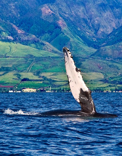
Humpback cruising offshore from Lahaina
Photo Credit: flickr.com
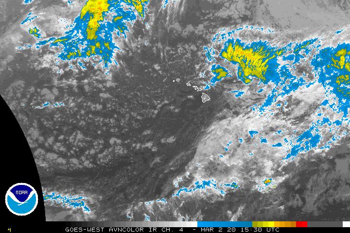
The Central Pacific Hurricane Center (CPHC) continues tracking tropical depression Kika, located far to the southwest of the islands Monday night. Here’s a looping satellite picture, showing this tropical cyclone moving away towards the west. Here’s a storm tracking map showing this tropical system in relation to the Hawaiian Islands. Looking to the of Hawaii, you will also see recently downgraded tropical storm Hernan in the eastern Pacific. Hernan is a gradually weakening tropical cyclone, which will dissipating in strength, as it moves over cooler water through the remainder of its life cycle. Despite all this tropical activity, neither of these storms will have any influence on our local weather here in the Hawaiian Islands. There is a chance that whatever leftover moisture, which may be involved with, what will then be former tropical cyclone Hernan…may bring some showers to the southern part of the state next week.
~~~ This satellite image shows the two main areas of interest around the Hawaiian Islands. The area to the southwest, to the lower left of the islands, is tropical depression Kika…no problem there as this system remains on course towards the west. The area of disturbed weather to the east-southeast, is a region of tropical moisture, around a vortex of low pressure. All the computer models show this tropical disturbance moving towards our islands, then turning westward…remaining to the south of Hawaii. There remains the good chance of showers arriving later this week, and that our local trade winds will accelerate as this tropical system moves by Friday into the weekend.
It’s early Monday evening here in Kihei, Maui, as I begin writing this last section of today’s narrative.
The new work started off in a pretty good way, with the trade winds still quite snappy, along with more of those common windward biased showers.The strongest wind gust that I saw at 5pm was once again, which isn’t the slightest bit unusual…at Maalaea Bay on Maui, at 40 mph. The island of Lanai wasn’t too far behind, with the cup anemometer there twirling to the tune of 37 mph. Looking ahead, Tuesday will be a transition day, with our local trade winds finally starting to calm down. They will remain on the lighter side through Thursday, due to storms filing by in the middle latitudes to our north. Friday will be another transition day, as the trade winds surge again, and with quite a few showers riding in on the strengthening trades. The source of these showers will be an area of disturbed weather moving by to the south of Hawaii. I’ll be back very early Tuesday morning with your next new weather narrative from paradise, I hope you have a great Monday night until then! Aloha for now…Glenn.
Note:
I will be flying to Honolulu late Wednesday afternoon, to attend a Climate Conference on Oahu Thursday and Friday. Friends on Oahu, who live on the windward side in Kailua, have invited me to spend some time with them Friday night, Saturday and Sunday. I will fly back to Maui late Sunday afternoon. This means that Iwill not be doing my tv weather show on Thursday, and then again not on Friday…which is a local state holiday. I will not be updating, or at least not regularly, this website during that time frame. The daily forecasts, in the upper left hand column on this and all other pages, will continue to have the latest weather forecasts however. Glenn
Information about tonight’s Perseids Meteor shower
Interesting:
A new variety of premium grapes debuted in
The average price for the Ruby Roman grapes at Monday’s auction was about $245 a bunch. Isu said local farmers hope to sell 1,500 bunches, or 1 ton, of the grapes by mid-September. Fruit is generally expensive in
Interesting2:
Already threatened by a thaw of ice around the North Pole, the polar bear’s title as the top Arctic predator may under challenge from a shark. Scientists researching how far sharks hunt seals in the Arctic were stunned in June to find part of the jaw of a young polar bear in the stomach of a
He said he had not heard of a shark eating a bear before and it was a "million dollar question" for researchers as to whether
Interesting3:
As the Arctic Ocean warms this century, shellfish, snails and other animals from the Pacific Ocean will resume an invasion of the northern Atlantic that was interrupted by cooling conditions three million years ago, predict Geerat Vermeij, professor of geology at the University of California, Davis, and Peter Roopnarine at the California Academy of Sciences. Climate models predict a nearly ice-free
At least 77 molluscan lineages, about a third of the species of shallow-water shellfish in the Bering Sea, have the potential to spread to the
Interesting4: If wind energy converters are located anywhere near a residential area, they must never become too noisy even in high winds. Most such power units try to go easy on their neighbors’ ears, but even the most careful design cannot prevent noise from arising at times: One source is the motion of the rotor blades, another is the cogwheels that produce vibrations in the gearbox. These are relayed to the tower of the wind turbine, where they are emitted across a wide area — and what the residents hear is a humming noise. "People find these monotone sounds particularly unpleasant, rather like the whining of a mosquito," says André Illgen, a research associate at the Fraunhofer Institute for Machine Tools and Forming Technology IWU in
If the wind energy converters hum too loudly, they are only permitted to operate under partial load: They rotate at a slower speed and generate less electricity. In some cases the operators have to install additional damping systems or even replace the gearbox — an expensive business. However, the effectiveness of the passive damping systems used until now is somewhat limited: They only absorb noise at a certain frequency. Since modern wind energy converters adapt their rotational speed to the wind velocity in order to generate as much electricity as possible, however, the frequency of the humming sound also varies. Despite noise attenuation measures, humming noises penetrate the surrounding area.