March 2010
Monthly Archive
Posted by Glenn
[3] Comments
March 11-12, 2010
Air Temperatures – The following maximum temperatures were recorded across the state of Hawaii Thursday afternoon:
Lihue, Kauai – 78
Honolulu, Oahu – 82
Kaneohe, Oahu – 74
Kaunakakai, Molokai – 78
Kahului, Maui – 79
Hilo, Hawaii – 80
Kailua-kona – 81
Air Temperatures ranged between these warmest and coolest spots near sea level around the state – and on the highest mountains…at 4pm Thursday afternoon:
Barking Sands, Kauai – 81F
Hilo, Hawaii – 73
Haleakala Crater – 50 (near 10,000 feet on Maui)
Mauna Kea summit – 34 (near 14,000 feet on the Big Island)
Precipitation Totals – The following numbers represent the largest precipitation totals (inches) during the last 24 hours on each of the major islands, as of Thursday afternoon:
0.58 Mount Waialaele, Kauai
2.36 South Fork Kaukonahua, Oahu
0.01 Molokai
0.00 Lanai
0.00 Kahoolawe
1.90 Puu Kukui, Maui
1.58 Saddle Quarry, Big Island
Marine Winds – Here’s the latest (automatically updated) weather map showing high pressure systems to the northwest through northeast of Hawaii. The winds will be strong and gusty…gradually losing strength into the weekend.
Satellite and Radar Images: To view the cloud conditions we have here in Hawaii, please use the following satellite links, starting off with this Infrared Satellite Image of the islands to see all the clouds around the state during the day and night. This next image is one that gives close images of the islands only during the daytime hours, and is referred to as a Close-up visible image. This next image shows a larger view of the Pacific…giving perspective to the wider ranging cloud patterns in the Pacific Ocean. Finally, here’s a Looping IR satellite image, making viewable the clouds around the islands 24 hours a day. To help you keep track of where any showers may be around the islands, here’s the latest animated radar image.
Hawaii’s Mountains – Here’s a link to the live webcam on the summit of near 14,000 foot Mauna Kea on the Big Island of Hawaii. The tallest peak on the island of Maui is the Haleakala Crater, which is near 10,000 feet in elevation. These two webcams are available during the daylight hours here in the islands…and when there’s a big moon rising just after sunset for an hour or two! Plus, during the nights and early mornings you will be able to see stars, and the sunrise too…depending upon weather conditions.
Tropical Cyclone activity in the eastern and central Pacific – Here’s the latest weather information coming out of the National Hurricane Center, covering the eastern north Pacific. You can find the latest tropical cyclone information for the central north Pacific (where Hawaii is located) by clicking on this link to the Central Pacific Hurricane Center. Here’s a tracking map covering both the eastern and central Pacific Ocean. A satellite image, which shows the entire ocean area between Hawaii and the Mexican coast…can be found here.
Aloha Paragraphs

Napping Hawaiian cat
The trade winds are still wound up pretty tight, with wind gusts having topped 40 mph again today at a couple of spots in Maui County, and on the Big Island. The pressure gradient across our central Pacific, at least in the area around the Hawaiian Islands, remains fairly steep. Despite this, the winds do seem to have come down from their even stronger realms a tad, which we saw earlier in the week. Nonetheless, the NWS forecast office in Honolulu is keeping small craft wind advisories active across every square inch of our coastal marine environment. All this wind, not only locally, but also well upstream of the islands, is keeping rough and choppy waves…breaking along our east facing beaches. Thus, we see the high surf advisory flags stuck in the sand along those windward shores.
The winds are expected to ease up going forward, perhaps a little more tomorrow, than what we saw today…and then more significantly by the weekend. This will be caused by our high pressure systems, now positioned to the northwest through northeast, losing strength. This weather map shows a 1029 millibar high pressure system to the northwest, with its 1024 millibar counterpart to the northeast. Meanwhile, we also see a very deep 96 millibar storm to the northwest, moving very rapidly towards our central Pacific. This storm has a cold front draping southwest from its center, with hurricane force winds blowing behind it. The computer models show this frontal boundary arriving near Kauai Sunday night or Monday morning. The latest iteration of the GFS model now shows the frontal cloud band slowing way down as it approaches Kauai. This may limit the frontal showers for the areas past Oahu. However, here could be some prefrontal showers ahead of the front, or perhaps more likely…moisture associated with the front being carried onto the north and northeast coasts and slopes.
Looking even further ahead, the computer models are showing a second cold front approaching the state around the middle of next week. If we consider the drought conditions around the state now, we’re hoping that the postfrontal showers (from this next front) brings good precipitation to the windward sides Monday and Tuesday. Then, the models go on to show another cold front arriving around next Wednesday, posing the chance of more much needed moisture. Perhaps looking a bit too far into the future, the GFS model is showing a third cold front arriving next weekend. It seems that after a break from lots of cold fronts coming our way during February, the trade winds have taken over in no uncertain terms during March. Perhaps we’re moving into another period of frontal activity…lets just hope these cold fronts bring more rain than those February ones did! As is always the case, it will take time to tell. Back to the moment, a good thing has been happening more recently…as the windward sides have seen more prolific rainfall than we’ve seen in quite some time.
It’s Thursday evening, as I begin writing the last section of today’s narrative. The winds have let up a bit, especially over the Kauai and Oahu end of the island chain. They are still quite uppity down around Maui and the Big Island. Just to get an idea about the nature of the winds, here’s the strongest gusts, at around 630pm Thursday – 25 mph on Kauai; 24 mph on Oahu; 28 mph on Molokai; 35 mph on Lanai; 33 Kahoolawe; 35 mph on Maui; and 40 mph at South Point on the Big Island. ~~~ Here in Kula, Maui, there isn’t any wind at around 7pm, while being partly cloudy and dry. The air temperature was running 62.2F degrees. I just got back from my evening walk, and feeding the cats…one of which named Kiwi, looks remarkably like the one in the picture above. I hope you have a great Thursday night, and perhaps you can meet me here again Friday morning. Aloha for now…Glenn.
Interesting: China and India joined almost all other major greenhouse gas emitters Tuesday in signing up to the climate accord struck in Copenhagen, boosting a deal strongly favored by the United States. More than 100 nations have now endorsed the Copenhagen Accord, a non-binding agreement reached after two weeks of tortuous wrangling at a 194-nation summit in December.
The accord plans $100 billion a year in climate aid for developing nations from 2020 and seeks to limit global warming to below 2 degrees Celsius (3.6F) above pre-industrial times, but produced no timetable of emission limits to reach that goal. Indian Environment Minister Jairam Ramesh told parliament that India would also let its name join the list of "associated" countries on the three-page document.
"This will strengthen our negotiating position on climate change," Ramesh said. Chinese negotiator Su Wei wrote a one-sentence letter to the U.N. Climate Change Secretariat in Bonn saying that it could "proceed to include China in the list." China, the United States, the European Union, Russia and India are the main emitters of the greenhouse gases that are blamed for global warming — mostly carbon dioxide from burning fossil fuels.
Only Russia has yet to associate with the deal. The endorsements are a small boost for the Accord, which environmentalists say was a bare-minimum outcome from a summit that many nations hoped would end with a broad, legally binding pact to fight climate change.
But they offer little indication of how, or when, rich and poor nations might agree on a binding mechanism for combating climate changes that scientists say will multiply droughts, floods, storms and heat waves, and dramatically raise sea levels. China and India have preferred since Copenhagen to stress the supremacy of the 1992 U.N. Climate Convention, agreed in Kyoto, which puts the emphasis on rich nations cutting emissions.
Interesting2: The sensitivity of Amazon rain forests to dry season droughts is still poorly understood, with reports of enhanced tree mortality and forest fires on one hand, and excessive forest greening on the other. In a current story there is a report that previous conclusions of large scale greening of the Amazon as a result of drought are not reproducible. Approximately 11%-12% of the drought stricken forests display greening, while, 28%-20% show browning or no change, and for the rest, the data are not of sufficient quality to characterize any changes.
These changes are also not unique; approximately similar changes are observed in non-drought years as well. The Amazon drought of 2005 was the worst ever recorded in the Amazon. The drought has turned rivers into grassy mud flats, killed tens of millions of fish, stranded hundreds of communities, and brought disease and economic despair to the region.
There have been other droughts such as in 1926, 1983, and 1998. These other droughts can be more linked to El Nino effects. Scientists are not certain as to the cause of the 2005 drought, although warmer water temperatures in the Atlantic Ocean are the leading suspect. Wet tropical forests are the most species rich biome, and tropical forests in the Americas such as along the Amazon River are consistently more species rich than the wet forests in Africa and Asia.
As the largest tract of tropical rain forest in the Americas, the Amazonian rain forests have unparalleled biodiversity. However extensive deforestation has occurred in the last few decades and the 2005 drought did not help. There had been earlier claims that the 2005 drought caused a "greening" of the Amazon. Tied to this thought was that available sunlight increased in this area.
In the March Geophysical Letters an article was published by several authors entitled: "Amazon Forests Did Not Green-up in the 2005 Drought". The authors included Arindam Samanta and Ranga B. Myneni. In this the authors concluded that only about 10% of the affected area increased in greenness and about three times this area became browner. The majority of the affected areas could not be determined.
At the same time sunlight (in the wavelengths most useful for plant life) decreased rather than decreased in most areas. There was no co-relation between drought severity and greenness changes, which is contrary to the idea of drought induced greening. Finally the study concluded that the spatial patterns of Enhanced Vegetation Index changes seen in drought year 2005 are not unique in comparison to non” drought years.
Interesting3: Two billion people worldwide do their cooking on open fires, producing sooty pollution that shortens millions of lives and exacerbates global warming. If widely adopted, a new generation of inexpensive, durable cook stoves could go a long way toward alleviating this problem. With a single, concerted initiative, says Lakshman Guruswami, the world could save millions of people in poor nations from respiratory ailments and early death, while dealing a big blow to global warming — and all at a surprisingly small cost.
"If we could supply cheap, clean-burning cook stoves to the large portion of the world that burns biomass," says Guruswami, a Sri Lankan-born professor of international law at the University of Colorado, "we could address a significant international public health problem, and at the same stroke cut a major source of warming." Sooty, indoor air pollution from open wood or other biomass fires has long been linked to health problems and deaths.
More recently, scientists have been surprised to learn that black carbon — not only from biomass fires but from dirty diesel engines and other sources — is a far larger contributor to global warming than previously suspected: The dark particles absorb and retain heat close to the Earth’s surface that might otherwise be reflected. Some two billion people around the world, Guruswami notes, do most or all of their cooking and heating with fires from simple biomass — dried dung, wood, brush, or crop residues.
In India alone, the ratio is much higher — about three-fourths. "Think about that," says Guruswami, who directs his university’s Center for Energy and Environmental Security. "Two billion people, one-third of the people on Earth, are caught in a time warp, with no access to modern energy. They got energy from Prometheus a long time ago, and that was it."
Interesting4: Consider this T-shirt: It can monitor your heart rate and breathing, analyze your sweat and even cool you off on a hot summer’s day. What about a pillow that monitors your brain waves, or a solar-powered dress that can charge your MP3 player? This is not science fiction — this is cotton in 2010.
Now, the laboratory of Juan Hinestroza, assistant professor of Fiber Science and Apparel Design, has developed cotton threads that can conduct electric current as well as a metal wire can, yet remain light and comfortable enough to give a whole new meaning to multi-use garments.
This technology works so well that simple knots in such specially treated thread can complete a circuit — and solar-powered dress with this technology literally woven into its fabric will be featured at the annual Cornell Design League Fashion Show on Saturday, March 13 at Cornell University’s Barton Hall.
Using multidisciplinary nanotechnology developed at Cornell in collaboration with the universities at Bologna and Cagliari, Italy, Hinestroza and his colleagues developed a technique to permanently coat cotton fibers with electrically conductive nanoparticles. "We can definitively have sections of a traditional cotton fabric becoming conductive, hence a great myriad of applications can be achieved," Hinestroza said.
"The technology developed by us and our collaborators allows cotton to remain flexible, light and comfortable while being electronically conductive," Hinestroza said. "Previous technologies have achieved conductivity but the resulting fiber becomes rigid and heavy. Our new techniques make our yarns friendly to further processing such as weaving, sewing and knitting." This technology is beyond the theory stage.
Hinestroza’s student, Abbey Liebman, was inspired by the technology enough to design a dress that actually uses flexible solar cells to power small electronics from a USB charger located in the waist. The charger can power a smartphone or an MP3 player. "Instead of conventional wires, we are using our conductive cotton to transmit the electricity — so our conductive yarns become part of the dress," Hinestroza said. "Cotton used to be called the ‘fabric of our lives’ but based on these results, we can now call it ‘The fabric of our lights.’"
Posted by Glenn
[9] Comments
March 10-11, 2010
Air Temperatures – The following maximum temperatures were recorded across the state of Hawaii Wednesday afternoon:
Lihue, Kauai – 78
Honolulu, Oahu – 81
Kaneohe, Oahu – 78
Kaunakakai, Molokai – 78
Kahului, Maui – 77
Hilo, Hawaii – 76
Kailua-kona – 81
Air Temperatures ranged between these warmest and coolest spots near sea level around the state – and on the highest mountains…at 5pm Wednesday evening:
Barking Sands, Kauai – 81F
Hilo, Hawaii – 70
Haleakala Crater – 41 (near 10,000 feet on Maui)
Mauna Kea summit – 32 (near 14,000 feet on the Big Island)
Precipitation Totals – The following numbers represent the largest precipitation totals (inches) during the last 24 hours on each of the major islands, as of Wednesday afternoon:
1.45 Mount Waialaele, Kauai
0.92 South Fork Kaukonahua, Oahu
0.10 Molokai
0.00 Lanai
0.00 Kahoolawe
2.99 Kaupo Gad, Maui
2.06 Glenwood, Big Island
Marine Winds – Here’s the latest (automatically updated) weather map showing high pressure systems to the northwest through northeast of Hawaii. The winds will be strong and gusty…gradually losing some strength.
Satellite and Radar Images: To view the cloud conditions we have here in Hawaii, please use the following satellite links, starting off with this Infrared Satellite Image of the islands to see all the clouds around the state during the day and night. This next image is one that gives close images of the islands only during the daytime hours, and is referred to as a Close-up visible image. This next image shows a larger view of the Pacific…giving perspective to the wider ranging cloud patterns in the Pacific Ocean. Finally, here’s a Looping IR satellite image, making viewable the clouds around the islands 24 hours a day. To help you keep track of where any showers may be around the islands, here’s the latest animated radar image.
Hawaii’s Mountains – Here’s a link to the live webcam on the summit of near 14,000 foot Mauna Kea on the Big Island of Hawaii. The tallest peak on the island of Maui is the Haleakala Crater, which is near 10,000 feet in elevation. These two webcams are available during the daylight hours here in the islands…and when there’s a big moon rising just after sunset for an hour or two! Plus, during the nights and early mornings you will be able to see stars, and the sunrise too…depending upon weather conditions.
Tropical Cyclone activity in the eastern and central Pacific – Here’s the latest weather information coming out of the National Hurricane Center, covering the eastern north Pacific. You can find the latest tropical cyclone information for the central north Pacific (where Hawaii is located) by clicking on this link to the Central Pacific Hurricane Center. Here’s a tracking map covering both the eastern and central Pacific Ocean. A satellite image, which shows the entire ocean area between Hawaii and the Mexican coast…can be found here.
Aloha Paragraphs

Still windy for a while yet
We’ve moved through the most intense part of this latest windy episode, although the winds are still remarkably strong and gusty on each of the individual islands at mid-week. These winds are still up in the 30, 40 and 50 mph range…at least in terms of gusts. I say past the peak, which is referring to some of the gusts that were up around 60 mph over the last day or two! The source of these unusually blustery winds continues to be the steep pressure gradient between high pressure cells to our northwest through northeast…and low pressure down near the equator. This weather map shows this well, including the nearly straight east to west orientation of the winds streaming across our island chain now.
We have some changes up ahead, as our trade winds finally begin to ease up…as we move into the weekend. This slowing down of the trade winds, and their associated veering, will be prompted by the approach of a cold front…forecast to arrive later in the day Sunday. The computer models suggest that our winds will swing around to the southeast. Winds from this direction, puts most of the state in a wind shadow, at least the smaller islands downwind from the blocking Big Island. At the same time, southeast winds can effectively carry volcanic haze up from the Big Island vents, over other parts of the island chain as well. The cold front is expected to arrive, along with fairly generous rainfall later Sunday into Monday.
The computer models then go on to show a new high pressure system moving into range to our northwest…in the wake of the cold frontal passage (fropa). This new high pressure cell will bring a temporary bout of cooler north to northeast winds. Temporary…because shortly thereafter, another cold front begins to push in our direction. The computer models show quite a bit of moisture getting hung-up along the windward sides after the cold front. This means that there’s a good chance of lots of windward showers, which is a good thing in terms of the dry weather we’ve had this winter. We’ve actually had quite a bit of good showers along the windward sides lately however, and if the cold front does what it’s suppose to do, followed by more showers…this would be a very good turn of events! More and more showers, that’s a good thing now, pushing the drought back several steps in its tracks.
It’s Wednesday evening, as I begin writing the last section of today’s narrative. The trade winds have blown all day, and continue to rush through the Aloha state as we push into the night Wednesday. Here’s the strongest gusts, this time at around 5pm Wednesday evening – 35 mph on Kauai; 37 mph on Oahu; 42 mph on Molokai; 43 mph on Lanai; 46 Kahoolawe; 36 mph on Maui; and 40 mph at South Point on the Big Island. As we move into Thursday onward, the winds will begin to slow down, due to the weakening of our high pressure systems to the north. As we get into the weekend, our winds will become even lighter from the southeast. This may bring some volcanic haze up from the Big Island vents to Maui County, perhaps further up the island chain. Due to the extended drought conditions, I’m getting more excited about the prospect of a cold front bringing generous showers Sunday into early next week. The following chilly north to northeast winds may keep showers falling along the north and northeast coasts and slopes for several days thereafter. By the way, another cold front may approach the islands around the middle of next week, more about that soon. ~~~ As you might have seen at the bottom of this page, where folks leave reponses to me, to us, there was a note from Shawn, who wrote in saying that there had been 50-67 mph gusts in Launiupoko…which is on west Maui, not far from typically light winded Lahaina town! As I wrote in my response to her – Wow! I’m heading out in a few minutes for the drive back upcountry to Kula, Maui. Looking out the window here in Kihei, it’s not totally calm, at least where I am in upper Kihei, but just a gentle breeze at most. I’ll be back here early Thursday morning with your next new weather narrative, I hope you have a great Wednesday night until then! Aloha for now…Glenn.
Extra: incredible music video
Interesting: China and India joined almost all other major greenhouse gas emitters Tuesday in signing up to the climate accord struck in Copenhagen, boosting a deal strongly favored by the United States. More than 100 nations have now endorsed the Copenhagen Accord, a non-binding agreement reached after two weeks of tortuous wrangling at a 194-nation summit in December.
The accord plans $100 billion a year in climate aid for developing nations from 2020 and seeks to limit global warming to below 2 degrees Celsius (3.6F) above pre-industrial times, but produced no timetable of emission limits to reach that goal. Indian Environment Minister Jairam Ramesh told parliament that India would also let its name join the list of "associated" countries on the three-page document.
"This will strengthen our negotiating position on climate change," Ramesh said. Chinese negotiator Su Wei wrote a one-sentence letter to the U.N. Climate Change Secretariat in Bonn saying that it could "proceed to include China in the list." China, the United States, the European Union, Russia and India are the main emitters of the greenhouse gases that are blamed for global warming — mostly carbon dioxide from burning fossil fuels.
Only Russia has yet to associate with the deal. The endorsements are a small boost for the Accord, which environmentalists say was a bare-minimum outcome from a summit that many nations hoped would end with a broad, legally binding pact to fight climate change.
But they offer little indication of how, or when, rich and poor nations might agree on a binding mechanism for combating climate changes that scientists say will multiply droughts, floods, storms and heat waves, and dramatically raise sea levels. China and India have preferred since Copenhagen to stress the supremacy of the 1992 U.N. Climate Convention, agreed in Kyoto, which puts the emphasis on rich nations cutting emissions.
Interesting2: The sensitivity of Amazon rain forests to dry season droughts is still poorly understood, with reports of enhanced tree mortality and forest fires on one hand, and excessive forest greening on the other. In a current story there is a report that previous conclusions of large scale greening of the Amazon as a result of drought are not reproducible. Approximately 11%-12% of the drought stricken forests display greening, while, 28%-20% show browning or no change, and for the rest, the data are not of sufficient quality to characterize any changes.
These changes are also not unique; approximately similar changes are observed in non-drought years as well. The Amazon drought of 2005 was the worst ever recorded in the Amazon. The drought has turned rivers into grassy mud flats, killed tens of millions of fish, stranded hundreds of communities, and brought disease and economic despair to the region.
There have been other droughts such as in 1926, 1983, and 1998. These other droughts can be more linked to El Nino effects. Scientists are not certain as to the cause of the 2005 drought, although warmer water temperatures in the Atlantic Ocean are the leading suspect. Wet tropical forests are the most species rich biome, and tropical forests in the Americas such as along the Amazon River are consistently more species rich than the wet forests in Africa and Asia.
As the largest tract of tropical rain forest in the Americas, the Amazonian rain forests have unparalleled biodiversity. However extensive deforestation has occurred in the last few decades and the 2005 drought did not help. There had been earlier claims that the 2005 drought caused a "greening" of the Amazon. Tied to this thought was that available sunlight increased in this area.
In the March Geophysical Letters an article was published by several authors entitled: "Amazon Forests Did Not Green-up in the 2005 Drought". The authors included Arindam Samanta and Ranga B. Myneni. In this the authors concluded that only about 10% of the affected area increased in greenness and about three times this area became browner. The majority of the affected areas could not be determined.
At the same time sunlight (in the wavelengths most useful for plant life) decreased rather than decreased in most areas. There was no co-relation between drought severity and greenness changes, which is contrary to the idea of drought induced greening. Finally the study concluded that the spatial patterns of Enhanced Vegetation Index changes seen in drought year 2005 are not unique in comparison to non” drought years.
Interesting3: Two billion people worldwide do their cooking on open fires, producing sooty pollution that shortens millions of lives and exacerbates global warming. If widely adopted, a new generation of inexpensive, durable cook stoves could go a long way toward alleviating this problem. With a single, concerted initiative, says Lakshman Guruswami, the world could save millions of people in poor nations from respiratory ailments and early death, while dealing a big blow to global warming — and all at a surprisingly small cost.
"If we could supply cheap, clean-burning cook stoves to the large portion of the world that burns biomass," says Guruswami, a Sri Lankan-born professor of international law at the University of Colorado, "we could address a significant international public health problem, and at the same stroke cut a major source of warming." Sooty, indoor air pollution from open wood or other biomass fires has long been linked to health problems and deaths.
More recently, scientists have been surprised to learn that black carbon — not only from biomass fires but from dirty diesel engines and other sources — is a far larger contributor to global warming than previously suspected: The dark particles absorb and retain heat close to the Earth’s surface that might otherwise be reflected. Some two billion people around the world, Guruswami notes, do most or all of their cooking and heating with fires from simple biomass — dried dung, wood, brush, or crop residues.
In India alone, the ratio is much higher — about three-fourths. "Think about that," says Guruswami, who directs his university’s Center for Energy and Environmental Security. "Two billion people, one-third of the people on Earth, are caught in a time warp, with no access to modern energy. They got energy from Prometheus a long time ago, and that was it."
Interesting4: Consider this T-shirt: It can monitor your heart rate and breathing, analyze your sweat and even cool you off on a hot summer’s day. What about a pillow that monitors your brain waves, or a solar-powered dress that can charge your MP3 player? This is not science fiction — this is cotton in 2010.
Now, the laboratory of Juan Hinestroza, assistant professor of Fiber Science and Apparel Design, has developed cotton threads that can conduct electric current as well as a metal wire can, yet remain light and comfortable enough to give a whole new meaning to multi-use garments.
This technology works so well that simple knots in such specially treated thread can complete a circuit — and solar-powered dress with this technology literally woven into its fabric will be featured at the annual Cornell Design League Fashion Show on Saturday, March 13 at Cornell University’s Barton Hall.
Using multidisciplinary nanotechnology developed at Cornell in collaboration with the universities at Bologna and Cagliari, Italy, Hinestroza and his colleagues developed a technique to permanently coat cotton fibers with electrically conductive nanoparticles. "We can definitively have sections of a traditional cotton fabric becoming conductive, hence a great myriad of applications can be achieved," Hinestroza said.
"The technology developed by us and our collaborators allows cotton to remain flexible, light and comfortable while being electronically conductive," Hinestroza said. "Previous technologies have achieved conductivity but the resulting fiber becomes rigid and heavy. Our new techniques make our yarns friendly to further processing such as weaving, sewing and knitting." This technology is beyond the theory stage.
Hinestroza’s student, Abbey Liebman, was inspired by the technology enough to design a dress that actually uses flexible solar cells to power small electronics from a USB charger located in the waist. The charger can power a smartphone or an MP3 player. "Instead of conventional wires, we are using our conductive cotton to transmit the electricity — so our conductive yarns become part of the dress," Hinestroza said. "Cotton used to be called the ‘fabric of our lives’ but based on these results, we can now call it ‘The fabric of our lights.’"
Posted by Glenn
1 Comment
March 9-10, 2010
Air Temperatures – The following maximum temperatures were recorded across the state of Hawaii Tuesday afternoon:
Lihue, Kauai – 76
Honolulu, Oahu – 81
Kaneohe, Oahu – 78
Kaunakakai, Molokai – 79
Kahului, Maui – 79
Hilo, Hawaii – 78
Kailua-kona – 81
Air Temperatures ranged between these warmest and coolest spots near sea level around the state – and on the highest mountains…at 4pm Tuesday afternoon:
Barking Sands, Kauai – 81F
Hilo, Hawaii – 73
Haleakala Crater – 37 (near 10,000 feet on Maui)
Mauna Kea summit – 28 (near 14,000 feet on the Big Island)
Precipitation Totals – The following numbers represent the largest precipitation totals (inches) during the last 24 hours on each of the major islands, as of Tuesday afternoon:
0.87 Mount Waialaele, Kauai
0.41 Oahu Forest NWR, Oahu
0.20 Molokai
0.18 Lanai
0.00 Kahoolawe
0.83 Puu Kukui, Maui
0.69 Kawainui Stream, Big Island
Marine Winds – Here’s the latest (automatically updated) weather map showing high pressure systems to the north through northeast of Hawaii. The winds will be strong and gusty…gradually veering around to the ENE and east.
Satellite and Radar Images: To view the cloud conditions we have here in Hawaii, please use the following satellite links, starting off with this Infrared Satellite Image of the islands to see all the clouds around the state during the day and night. This next image is one that gives close images of the islands only during the daytime hours, and is referred to as a Close-up visible image. This next image shows a larger view of the Pacific…giving perspective to the wider ranging cloud patterns in the Pacific Ocean. Finally, here’s a Looping IR satellite image, making viewable the clouds around the islands 24 hours a day. To help you keep track of where any showers may be around the islands, here’s the latest animated radar image.
Hawaii’s Mountains – Here’s a link to the live webcam on the summit of near 14,000 foot Mauna Kea on the Big Island of Hawaii. The tallest peak on the island of Maui is the Haleakala Crater, which is near 10,000 feet in elevation. These two webcams are available during the daylight hours here in the islands…and when there’s a big moon rising just after sunset for an hour or two! Plus, during the nights and early mornings you will be able to see stars, and the sunrise too…depending upon weather conditions.
Tropical Cyclone activity in the eastern and central Pacific – Here’s the latest weather information coming out of the National Hurricane Center, covering the eastern north Pacific. You can find the latest tropical cyclone information for the central north Pacific (where Hawaii is located) by clicking on this link to the Central Pacific Hurricane Center. Here’s a tracking map covering both the eastern and central Pacific Ocean. A satellite image, which shows the entire ocean area between Hawaii and the Mexican coast…can be found here.
Aloha Paragraphs

Windy weather continues
The unusually strong and gusty trade winds remain our main focus…which will carry showers to our windward sides this evening into Wednesday morning. Wind directions have been out of the northeast, although will be gradually becoming east-northeast to east over the next day or two. The winds have been strong enough, that wind chill has made it still feel somewhat chilly. This weather map shows high pressure systems strung out along the area north through northeast…pumping out these blustery winds.
These winds have prompted the NWS forecast office in Honolulu to continue the Small Craft Wind Advisories across all coastal waters, along with Wind Advisories over all those windiest areas on all the islands…which is unusual. In addition, we have High Surf Advisory flags posted on all our east facing beaches…for rough surf conditions. Finally, we have gale warnings active in the channels around Maui and the Big Island. The computer models suggest that the winds will shift a little, becoming slightly lighter after Wednesday…remaining in force through the rest of this work week though.
We can still see the trough of low pressure over to the east of the islands…although it is now almost gone. Here’s a satellite image showing that area of diminished clouds. This fading upper level trough, has moved far enough away now, to have lost its influence over our area. An upper level ridge moving over the state now, which will put an end to the threat of heavy showers. An area of clouds however, will bring some showers overnight into Wednesday morning. The GFS computer model continues to show a cold front reaching the islands this Sunday, with showers extending into Monday, followed by what else…but more cool blustery north to northeast winds!
As noted in the paragraphs above, we have locally strong and gusty winds blowing. They have been able to funnel through valley’s, bringing gusty winds into some leeward areas. Tuesday evening still finds Gale Warnings placed in the Alenuihaha Channel between Maui and the Big Island, and in the Pailolo Channel…between Maui and Molokai. Small Craft Wind Advisories are active across all of Hawaii’s coastal waters too. Meanwhile, those windiest locations around the state, now have a Wind Advisory for sustained winds of 30 mph, with higher gusts locally to near 50 mph or above. While we’re listing all these things, we shouldn’t forget the high surf advisories for all the east facing beaches across the state…caused by the strong winds blowing over the ocean.
It’s Tuesday evening, as I begin writing this last section of today’s narrative. The trade winds are really cranking now, definitely as strong as they were at the beginning of last week…almost a perfect match in fact. Just to nail down this fact, here’s the strongest gusts again, this time at around 5pm Tuesday evening – 42 mph on Kauai; 44 mph on Oahu; 38 mph on Molokai; 46 mph on Lanai; 50 Kahoolawe; 48 mph on Maui; and 55.3 mph at Kawaihae on the Big Island. These are big numbers, especially that 55 mph observation on the Big Island! As the winds turn more easterly, there will be an island blocking effect, calming the winds down in some areas. Plus, as we move past Wednesday, the winds will slow down further, due to the weakening of our high pressure systems to the north. ~~~ I’m just about ready to leave Kihei, for the drive back upcountry to Kula, Maui. Looking out the window here before I leave, it’s still breezy outside, although not so bad as it was earlier. At one point, when I left to go to lunch, I honestly had a bit of a hard time pushing the door open…with the gusty winds pushing in from the other side! I anticipate another blustery day Wednesday, and will be back early in the morning to discuss the new details about that then. I hope you have a great Tuesday night until then! Aloha for now…Glenn.
Extra: This link is for sunrise and sunset times here in Hawaii…please bookmark
Interesting: A string of earthquakes hitting Haiti, Chile and as recently as Turkey this year have fueled the speculation that the "clustering" of temblors may signal the Earth is entering a new period of earthquake cycle, but whether the theory stands is still an issue of debate within the science community. Stephen S. Gao, a geophysics professor at Missouri University of Science and Technology in the United States, is one of the scientists who argued that the Earth has been witnessing increased activity.
"It is clear that the Earth is significantly more active over the past 15 years than the 20 years before," he told Xinhua in a recent interview. Gao’s statement is based on the study of the so-called "moment release," a measure of the product of the area ruptured by an earthquake and the displacement between the two sides of the fault.
His calculation shows that the moment release per year between 1995 and 2010 is about four times as large as that between 1975 and 1994. Even when the 2004 Sumatra earthquake in Indonesia and its large aftershocks and this year’s 8.8-magnitude earthquake in Chile are not counted, the moment release over the past 15 years is still twice as large as that of the previous two decades.
Gao believed that the increased activity could simply be natural fluctuations of the stress field in the Earth’s lithosphere, or the outer solid part. "We do not have a long-enough record of instrumentally determined earthquakes to determine if this is true or not for a longer period," noted the geophysicist.
"Although we are still trying to come up with some explanations for the higher activity over the past 15 years, I do not think global warming or human activities have much to do with it," he added. According to a recent report by the newspaper USA Today, Marcia McNutt, director of the U.S. Geological Survey (USGS), said that global earthquakes in recent years, starting with the 9.1- magnitude one in Indonesia in 2004, follow a 50-year cycle of earthquake activity.
The last cycle, in the 1960s, produced two mega-quakes with a magnitude-9.5 earthquake in Chile and a magnitude-9.2 one in Alaska. The one in Chile in 1960 is the largest earthquake ever instrumentally recorded. Other scientists in the United States, however, are not as convinced that a new spike of major earthquakes is emerging.
Statistics by the USGS indicated that seven out of the 15 largest earthquakes since 1900 occurred in the period between 1950 and 1964, with four quakes on the top 15 list happening after the end of 2004 including the 8.8-magnitude one in Chile this year. However, when a larger pool of earthquakes with magnitude 8.0 or above are considered, the pattern of the "clustering" or " grouping" of large quakes becomes much less apparent, said Jian Lin, a geologist at the Woods Hole Oceanographic Institution.
Whether recent earthquakes are part of a new phase of long-term cycle is subject to ongoing research, he told Xinhua. "The answer to the question will also depend on how large the earthquakes one would like to consider in a statistical study," Lin said. Dr. Chris Goldfinger, a marine geologist at Oregon State University, also cautioned that scientists should not rush to conclusions.
A global "clustering" of big earthquakes is very difficult to test, as "our history for most faults is not long enough," said Goldfinger, director of the university’s Active Tectonics and Seafloor Mapping Laboratory. It’s not impossible that there could be such "clustering," as earthquakes may trigger other earthquakes through transfer of stress in the crust and could result in a peak in earthquake activity, the scientists said. "Overall though, a general increase in earthquake frequency isn’t something that would be very likely without some tectonic explanation, I know of no such mechanism," he told Xinhua.
Interesting2: U.S. researchers estimate that an 18 percent tax on pizza and soda can push down U.S. adults’ calorie intake enough to lower their average weight by 5 pounds (2 kg) per year. Health The researchers, writing in the journal Archives of Internal Medicine on Monday, suggested taxing could be used as a weapon in the fight against obesity, which costs the United States an estimated $147 billion a year in health costs.
"While such policies will not solve the obesity epidemic in its entirety and may face considerable opposition from food manufacturers and sellers, they could prove an important strategy to address overconsumption, help reduce energy intake and potentially aid in weight loss and reduced rates of diabetes among U.S. adults," wrote the team led by Kiyah Duffey of the University of North Carolina at Chapel Hill.
With two-thirds of Americans either overweight or obese, policymakers are increasingly looking at taxing as a way to address obesity on a population level. California and Philadelphia have introduced legislation to tax soft drinks to try to limit consumption. CDC director Dr. Thomas Frieden supports taxes on soft drinks, as does the American Heart Association.
There are early signs that such a policy works. Duffey’s team analyzed the diets and health of 5,115 young adults aged age 18 to 30 from 1985 to 2006. They compared data on food prices during the same time. Over a 20-year period, a 10 percent increase in cost was linked with a 7 percent decrease in the amount of calories consumed from soda and a 12 percent decrease in calories consumed from pizza.
The team estimates that an 18 percent tax on these foods could cut daily intake by 56 calories per person, resulting in a weight loss of 5 pounds (2 kg) per person per year. "Our findings suggest that national, state or local policies to alter the price of less healthful foods and beverages may be one possible mechanism for steering U.S. adults toward a more healthful diet," Duffey and colleagues wrote.
In a commentary, Drs. Mitchell Katz and Rajiv Bhatia of the San Francisco Department of Public Health said taxes are an appropriate way to correct a market that favors unhealthy food choices over healthier options. They argued that the U.S. government should carefully consider food subsidies that contribute to the problem.
"Sadly, we are currently subsidizing the wrong things including the product of corn, which makes the corn syrup in sweetened beverages so inexpensive," they wrote. Instead, they argued that agricultural subsidies should be used to make healthful foods such as locally grown vegetables, fruits and whole grains less expensive.
Interesting3: The Toba super eruption occurred between 69,000 and 77,000 years ago at Lake Toba (present day Indonesia), and it is recognized as one of Earth’s largest known eruptions. The related catastrophe theory holds that this super volcanic event plunged the planet into a 6 to 10 year volcanic winter, which resulted in the world’s human population being reduced to 10,000 or even a mere 1,000 breeding pairs, creating a bottleneck in human evolution. Some researchers argue that the Toba eruption produced not only a catastrophic volcanic winter but also an additional 1,000 year cooling episode.
Newly discovered archaeological sites in southern and northern India have revealed how people lived before and after the colossal Toba volcanic eruption 74,000 years ago. According to the supporters of the genetic bottleneck theory, between 50,000 and 100,000 years ago human population suffered a severe population decrease (only 3,000 to 10,000 individuals survived).
Genetic evidence suggests that all humans alive today, despite apparent variety, are descended from a very small population, perhaps between 1,000 to 10,000 breeding pairs about 70,000 years ago. Ambrose and Rampino proposed in late 90s that this bottleneck could have been caused by the climate effects of the Toba eruption.
The supporters of the Toba catastrophe theory suggest that the eruption resulted in a global ecological disaster with extreme phenomena, such as worldwide vegetation destruction, and severe drought in the tropical rain forest belt and in monsoonal regions. Τhis massive environmental change created population bottlenecks in species that existed at the time.
Toba may have caused modern races to differentiate abruptly only 70,000 years ago, rather than gradually over one million years. The Toba explosion instantly destroyed all life in its immediate area. The eruption was more powerful than Krakatoa in 1883 that helped lower global temperatures by about 1.2 degrees C in the next year.
It also sent hundreds of cubic kilometers of ash and gases high into the atmosphere, even as the volcano itself collapsed inwards to form a huge sunken caldera (now Lake Toba). The gases, including sulfur dioxide, circled the globe on air currents, while the ash spread out to the north and west fanned by prevailing winds.
When the ash began to fall, it covered the Indian subcontinent and rained down into oceans from the Arabian Sea in the west to the South China Sea in the east. Around this time the earth slipped into a dramatically colder portion of the ice ages, and while this was underway before Toba’s eruption, the super volcano undoubtedly had an important influence.
An international, multidisciplinary research team, led by Oxford University in collaboration with Indian institutions, recently unveiled to a conference in Oxford what it calls "Pompeii like excavations" beneath the Toba ash in India. The seven year project examines the environment that humans lived in, their stone tools, as well as the plants and animal bones of the time.
The team has concluded that many forms of life survived the super eruption, contrary to other research which has suggested significant animal extinctions and genetic bottlenecks. According to the team, a potentially ground-breaking implication of the new work is that the species responsible for making the stone tools in India was Homo Sapiens. Stone tool analysis has revealed that the artifacts consist of cores and flakes, which are classified in India as Middle Palaeolithic and are similar to those made by modern humans in Africa.
"Though we are still searching for human fossils to definitively prove the case, we are encouraged by the technological similarities. This suggests that human populations were present in India prior to 74,000 years ago, or about 15,000 years earlier than expected based on some genetic clocks," said project director Dr Michael Petraglia, Senior Research Fellow in the School of Archaeology at the University of Oxford.
This exciting new information questions the idea that the Toba super eruption caused a worldwide environmental catastrophe. An area of widespread speculation about the Toba super eruption is that it nearly drove humanity to extinction. The fact that the Middle Palaeolithic tools of similar styles are found right before and after the Toba super eruption, suggests that the people who survived the eruption were the same populations, using the same kinds of tools, says Dr Petraglia.
Although some scholars have speculated that the Toba volcano led to severe and wholesale environmental destruction, the Oxford led research in India suggests that a mosaic of ecological settings was present in the world, and some areas experienced a relatively rapid recovery after the volcanic event. Dr Petraglia said: "This exciting new information questions the idea that the Toba super eruption caused a worldwide environmental catastrophe.
That is not to say that there were no ecological effects. We do have evidence that the ash temporarily disrupted vegetative communities and it certainly choked and polluted some fresh water sources, probably causing harm to wildlife and maybe even humans."
Interesting4: "This is the biggest, deepest crater on the Moon — an abyss that could engulf the United States from the East Coast through Texas," said Noah Petro of NASA’s Goddard Space Flight Center in Greenbelt, Md. The impact punched into the layers of the lunar crust, scattering that material across the Moon and into space. The tremendous heat of the impact also melted part of the floor of the crater, turning it into a sea of molten rock. That was just an opening shot.
Asteroid bombardment over billions of years has left the lunar surface pockmarked with craters of all sizes, and covered with solidified lava, rubble, and dust. Glimpses of the original surface, or crust, are rare, and views into the deep crust are rarer still. Fortunately, a crater on the edge of the South Pole-Aitken basin may provide just such a view. Called the Apollo Basin and formed by the later impact of a smaller asteroid, it still measures a respectable 300 miles across.
"It’s like going into your basement and digging a deeper hole," said Petro. "We believe the central part of the Apollo Basin may expose a portion of the Moon’s lower crust. If correct, this may be one of just a few places on the Moon where we have a view into the deep lunar crust, because it’s not covered by volcanic material as many other such deep areas are.
Just as geologists can reconstruct Earth’s history by analyzing a cross-section of rock layers exposed by a canyon or a road cut, we can begin to understand the early lunar history by studying what’s being revealed in Apollo." Petro presents his result March 4 during the Lunar and Planetary Science meeting in Houston, Texas.
Petro and his team made the discovery with the Moon Mineralogy Mapper (M3), a NASA instrument on board India’s Chandrayaan-1 lunar-orbiting spacecraft. Analysis of the light (spectra) in images from this instrument revealed that portions of the interior of Apollo have a similar composition to the impact melt in the South Pole-Aitken (SPA) basin.
As you go deeper into the Moon, the crust contains minerals have greater amounts of iron. When the Moon first formed, it was largely molten. Minerals containing heavier elements, like iron, sank down toward the core, and minerals with lighter elements, like silicon, potassium, and sodium, floated to the top, forming the original lunar crust.
"The asteroid that created the SPA basin probably carved through the crust and perhaps into the upper mantle. The impact melt that solidified to form the central floor of SPA would have been a mixture of all those layers. We expect to see that it has slightly more iron than the bottom of Apollo, since it went deeper into the crust.
This is what we found with M3. However, we also see that this area in Apollo has more iron than the surrounding lunar highlands, indicating Apollo has uncovered a layer of the lunar crust between what is typically seen on the surface and that in the deepest craters like SPA," said Petro. The lower crust exposed by Apollo survived the impact that created SPA probably because it was on the edge of SPA, several hundred miles from where the impact occurred, according to Petro.
Both SPA and Apollo are estimated to be among the oldest lunar craters, based on the large number of smaller craters superimposed on top of them. As time passes, old craters get covered up with new ones, so a crater count provides a relative age; a crater riddled with additional craters is older than one that appears relatively clean, with few craters overlying it.
As craters form, they break up the crust and form a regolith, a layer of broken up rock and dust, like a soil on the Earth. Although the Apollo basin is ancient and covered with regolith, it still gives a useful view of the lower crust because the smaller meteorite impacts that create most of the regolith don’t scatter material very far. "Calculations of how the regolith forms indicate that at least 50 percent of the regolith is locally derived," said Petro.
"So although what we’re seeing with M3 has been ground up, it still mostly represents the lower crust." It’s likely Earth wasn’t spared the abusive asteroid bombardment experienced by the Moon. Giant craters on other worlds across the solar system, including Mercury and Mars, indicate the rain from the heavens was widespread.
However, on Earth, the record of these events was rubbed out long ago. The crust gets recycled by plate tectonics and weathered by wind and rain, erasing ancient impact craters. "The Apollo and SPA basins give us a window into the earliest history of the Moon, and the Moon gives us a window into the violent youth of Earth," said Petro.
Posted by Glenn
[5] Comments
March 8-9, 2010
Air Temperatures – The following maximum temperatures were recorded across the state of Hawaii Monday afternoon:
Lihue, Kauai – 75
Honolulu, Oahu – 78
Kaneohe, Oahu – 77
Kaunakakai, Molokai – 75
Kahului, Maui – 79
Hilo, Hawaii – 75
Kailua-kona – 85
Air Temperatures ranged between these warmest and coolest spots near sea level around the state – and on the highest mountains…at 4pm Monday afternoon:
Kailua-kona – 81F
Hilo, Hawaii – 68
Haleakala Crater – 46 (near 10,000 feet on Maui)
Mauna Kea summit – 37 (near 14,000 feet on the Big Island)
Precipitation Totals – The following numbers represent the largest precipitation totals (inches) during the last 24 hours on each of the major islands, as of Monday afternoon:
1.66 Mount Waialaele, Kauai
1.37 Oahu Forest NWR, Oahu
1.30 Molokai
0.01 Lanai
0.14 Kahoolawe
3.34 Puu Kukui, Maui
1.59 Kawainui, Big Island
Marine Winds – Here’s the latest (automatically updated) weather map showing strong high pressure systems to the north and northeast Hawaii. The winds will be strong and gusty…gradually veering around from the NE to the ENE and east into mid-week.
Satellite and Radar Images: To view the cloud conditions we have here in Hawaii, please use the following satellite links, starting off with this Infrared Satellite Image of the islands to see all the clouds around the state during the day and night. This next image is one that gives close images of the islands only during the daytime hours, and is referred to as a Close-up visible image. This next image shows a larger view of the Pacific…giving perspective to the wider ranging cloud patterns in the Pacific Ocean. Finally, here’s a Looping IR satellite image, making viewable the clouds around the islands 24 hours a day. To help you keep track of where any showers may be around the islands, here’s the latest animated radar image.
Hawaii’s Mountains – Here’s a link to the live webcam on the summit of near 14,000 foot Mauna Kea on the Big Island of Hawaii. The tallest peak on the island of Maui is the Haleakala Crater, which is near 10,000 feet in elevation. These two webcams are available during the daylight hours here in the islands…and when there’s a big moon rising just after sunset for an hour or two! Plus, during the nights and early mornings you will be able to see stars, and the sunrise too…depending upon weather conditions.
Tropical Cyclone activity in the eastern and central Pacific – Here’s the latest weather information coming out of the National Hurricane Center, covering the eastern north Pacific. You can find the latest tropical cyclone information for the central north Pacific (where Hawaii is located) by clicking on this link to the Central Pacific Hurricane Center. Here’s a tracking map covering both the eastern and central Pacific Ocean. A satellite image, which shows the entire ocean area between Hawaii and the Mexican coast…can be found here.
Aloha Paragraphs

High surf advisory…east facing beaches
A couple of relatively strong high pressure systems, located to the north and northeast of Hawaii…are spinning out gusty winds in our direction Monday evening. At the same time, a trough of low pressure to our northeast is veering those winds into the state from the northeast. This is giving this rushing air some added strength…and a bit of a wind chill too. This weather map shows this situation quite well. These winds have prompted the NWS forecast office in Honolulu to issue not only Small Craft Wind Advisories across the coastal waters, and also Wind Advisories over those windier island locations in MauiCounty…and parts of the BigIsland. If all that wasn’t enough, they have also put out a Red Flag Warning for the leeward areas from Oahu down through the Big Island. The computer models suggest that the winds will shift a little, becoming true trade winds Tuesday, and remain in force through most of the rest of this week.
All this wind is carrying moisture in our direction, mostly generously along the north and east facing coasts and slopes. The winds are strong enough locally though, that some showers were taking a free ride over into the leeward sides…at least on the smaller islands. The trough of low pressure mentioned in the paragraph above, with its instability factor, has enhanced some of those showers during the day. Here’s a satellite image of that area of thunderstorms to our northeast. This trough, with its cold air aloft, is pretty far away, although not so far that it hasn’t influenced our weather a bit on the Big Island end of the island chain. Here’s a movie showing lightning (blue dots) strikes out over the ocean…associated with those thunderstorms. This trough will be moving away soon, taking the unstable atmospheric conditions, that sparked the locally heavy rainfall over parts of Maui. Nonetheless, incoming showers will wet the windward sides at times, although with an upper level ridge moving over the state, showers will back off some going forward. The GFS computer model shows a cold front reaching the islands later this coming Sunday…with showers extending into Monday and perhaps Tuesday. It’s probably too early to try and make this a solid possibility, although we could use the precipitation!
It’s Monday evening, as I begin writing this last section of today’s narrative. As noted in the paragraphs above, we have locally strong and gusty winds blowing. These breezes kept winds a bit lighter along the north and northeast to easterly areas Monday. They were able to funnel through some valley’s though, bringing gusty winds into some leeward areas. Monday evening finds a Gale Warning placed in the Alenuihaha Channel between Maui and the Big Island, and in the Pailolo Channel…between Maui and Molokai. Small Craft Wind Advisories are active across all of Hawaii’s coastal waters too. All the windy weather, with low relative humidities, has also necessitated a NWS issued Red Flag Warning…for increased fire danger in the leeward areas. Meanwhile, those windiest locations around Maui County and the Big Island, have an active Wind Advisory, for sustained winds of 30 mph, with higher gusts up towards 50 mph. ~~~ While I was at lunch today in Kihei, Maui, the winds were gusting up over 40 mph, with people actually having a difficult time walking along the sidewalks along South Kihei Road. Looking out the window here in Kihei at around 530pm, it’s still blustery out there. As the winds turn more easterly over the next couple of days, the winds will become more pronounced along the windward sides, and less so along the leeward sides. ~~~ I’m going to be driving through this windy weather back upcountry to Kula now. I’m pretty sure it was a windy day up there, and am going home to find out myself. I’ll be out there on the road for my walk, and then dinner and bed. I will however, be back early Tuesday morning with your next new weather narrative from paradise, I hope you have a great Monday night until then! Aloha for now…Glenn.
Extra: I have recently learned that all computer screens on the inside are covered with bacteria, dust, germs, etc. that can be dangerous to your health.
This is caused by a variety of reasons and it can prove to be a health hazard for everyone that uses the computer. Some at the CDC in Atlanta have recently said that this problem can be as dangerous as cigarette smoking because of the time that most of us are now spending on computers for work and personal reasons.
Click on this link to clean the inside of your screen.
Interesting: China’s western Qinghai Province, containing major deposits of the country’s "combustible ice," will see increased explorations for this emerging clean energy, Provincial Governor Luo Huining said. The plateau province plans to allow large energy companies along with researchers to tap this new source of energy while minimizing environmental threats, Luo said on the sidelines of the annual session of the National People’s Congress (NPC), China’s top legislature.
"Combustible ice," or natural gas hydrate, is mainly found in deep seas and atop plateaus. Approximately one cubic meter of "combustible ice" equals 164 cubic meters of regular natural gas. At a time of energy bottlenecks, the new energy resource has drawn interest from many countries. Additional attention has focused on the "ice" having a low proportion of impurities, resulting in it generating almost no pollutants when burned.
More than 100 countries around the world have found deposits of "combustible ice." The deposits in Qinghai Province, home to one-quarter of China’s total reserve on the Qinghai-Tibet Plateau, were discovered in September 2009. "Combustible ice" reserves on the Qinghai-Tibet Plateau are estimated to equal at least 35 billion tons of oil, which could supply energy to China for 90 years. Luo said tapping this new energy resource should be given high priority in China’s energy strategy.
Interesting2: U.S. Energy Secretary Steven Chu said that the United States needs to come up with a better system for storing or disposing of radioactive nuclear waste than a planned repository near Las Vegas. "The president has made it very clear that we are going to go beyond Yucca mountain. You should go beyond Yucca mountain," Chu said. "But instead of wringing my hands, let’s go forward and do something better."
The Obama administration, in January, announced it was stopping the license application for a long-planned multi-billion dollar nuclear waste storage site at Yucca Mountain near Las Vegas, which is opposed by environmental groups.
The Energy Department formally asked the Nuclear Regulatory Commission this week to withdraw the application. Chu said when the waste site was first started, there were conditions put in the requirements for the repository that didn’t really mesh with what scientists knew even back then.
"Long, long ago, it began looking less and less ideal," he said. "As time wore on, it’s got to be one of those things: ‘oops this might have happen, oops the Supreme Court says this…’," "Wouldn’t it be nice to step back and take a fresh look?" he asked.
Interesting3: Garlic is known in legend as great against vampires and it is quite nice in many delicious recipes. Researchers have now designed a urine test that can simultaneously measure the extent of a potential carcinogenic process and a marker of garlic consumption in humans. In a small pilot study, the test suggested that the more garlic people consumed, the lower the levels of the potential carcinogenic process were.
In some studies garlic has been found to have antibacterial, antiviral, and antifungal activity. However, these actions are less clear in humans. Garlic is also claimed to help prevent heart disease (including atherosclerosis, high cholesterol, and high blood pressure). Perhaps the most indispensable of herbs (or vegetables) garlic has a long and distinguished history that gives credence to its reputation as a one of the most valuable and seasoning and medicinal herbs in existence.
Garlic is mentioned by name in the Old Testament and the Muslim Quran as one of the foods the Israelites missed most during their years of wandering. Garlic was also considered sacred among the ancient Egyptians who buried it in the tombs of their deceased kings. It is not surprising that the ancients ascribed many properties to the very strong smelling garlic. It was alluded to drive away evil spirits, protect against werewolves and vampires, protect from evil and to bring good luck. The ancient Egyptians used garlic to treat many different conditions.
The ancient Greeks credited it for repelling scorpions and treating dog bites. During the course of history, garlic has been touted as a cure for everything from the common cold to the plague. Garlic has powerful antibiotic properties due to the presence of several sulfur compounds. The present research is all about body processes associated with nitrogen containing compounds. These processes include nitrosation, or the conversion of some substances found in foods or contaminated water into carcinogens.
“What we were after was developing a method where we could measure in urine two different compounds, one related to the risk for cancer, and the other, which indicates the extent of consumption of garlic,” said Earl Harrison, Dean’s Distinguished Professor of Human Nutrition at Ohio State and senior author of the study. “Our results showed that those were inversely related to one another — meaning that the more we had the marker for garlic consumption, the less there was of the marker for the risk of cancer.”
Ultimately, the scientists hope to find that a nutritional substance could be a way to control at least some body carcinogens. About 20 percent of nitrates that are consumed convert to nitrites. A cascade of events can convert these compounds into what are called nitrosamines, and many, but not all, nitrosamines are linked to cancer. Vegetables also contain nitrates, but previous research has suggested that the vitamin C in vegetables lowers the risk that those nitrates will convert to something toxic.
Researchers suspected that nutrients in garlic could have a similar antioxidant effects as does vitamin C. The study is published in a recent issue of the journal Analytical Biochemistry. The present research began with the small human study based at Penn State University. Researchers there fed participants a week long diet lacking any nitrates or garlic.
They then gave the participants a dose of sodium nitrate — in a formulation that would not become toxic, but which would show a marker in the urine of the potentially toxic process. “What this research does suggest is that garlic may play some role in inhibiting formation of these nitrogen based toxic substances.
This was a very small pilot study, so it’s also possible that the more garlic you have, the better it would be." When the urine samples were analyzed, it showed that the participants who had taken garlic had lower concentrations of the marker for nitrosation than did those who took no garlic.
Though the differences were slight, the consumption of 5 grams (1 clove) of garlic per day was associated with the lowest level of the marker for potential carcinogens. “What this research does suggest, however, is that garlic may play some role in inhibiting formation of these nitrogen based toxic substances.
This was very small pilot study, so it’s also possible that the more garlic you have, the better it would be. “So if you like garlic and you like garlic containing foods, go out and have as much as you want. There’s no indication it’s going to hurt you, and it may well help you.”
Interesting4: What if space held the key to producing alternative energy crops on Earth? That’s what researchers are hoping to find in a new experiment on the International Space Station. The experiment, National Lab Pathfinder-Cells 3, is aimed at learning whether microgravity can help jatropha curcas plant cells grow faster to produce biofuel, or renewable fuel derived from biological matter.
Jatropha is known to produce high quality oil that can be converted into an alternative energy fuel, or biofuel. By studying the effects of microgravity on jatropha cells, researchers hope to accelerate the cultivation of the plant for commercial use by improving characteristics such as cell structure, growth and development.
This is the first study to assess the effects of microgravity on cells of a biofuel plant. "As the search for alternate energy sources has become a top priority, the results from this study could add value for commercialization of a new product," said Wagner Vendrame, principal investigator for the experiment at the University of Florida in Homestead.
"Our goal is to verify if microgravity will induce any significant changes in the cells that could affect plant growth and development back on Earth." Launched on space shuttle Endeavour’s STS-130 mission in February, cell cultures of jatropha were sent to the space station in special flasks containing nutrients and vitamins.
The cells will be exposed to microgravity until they return to Earth aboard space shuttle Discovery’s STS-131 mission targeted for April. For comparison studies of how fast the cultures grow, a replicated set of samples are being maintained at the University of Florida’s Tropical Research and Education Center in Homestead.
"Watching the space shuttle go up carrying a little piece of my work is an indescribable experience," said Vendrame. "Knowing that my experiment could contribute to creating a sustainable means for biofuel production on Earth, and therefore making this a better world adds special value to the work."
Posted by Glenn
No Comments
March 7-8, 2010
Air Temperatures – The following maximum temperatures were recorded across the state of Hawaii Sunday afternoon:
Lihue, Kauai – 77
Honolulu, Oahu – 81
Kaneohe, Oahu – 77
Kaunakakai, Molokai – 80
Kahului, Maui – 82
Hilo, Hawaii – 79
Kailua-kona – 80
Air Temperatures ranged between these warmest and coolest spots near sea level around the state – and on the highest mountains…at 4pm Sunday afternoon:
Kahului, Maui – 79F
Molokai airport – 68
Haleakala Crater – 39 (near 10,000 feet on Maui)
Mauna Kea summit – 34 (near 14,000 feet on the Big Island)
Precipitation Totals – The following numbers represent the largest precipitation totals (inches) during the last 24 hours on each of the major islands, as of Sunday afternoon:
0.48 Wainiha, Kauai
0.95 Oahu Forest NWR, Oahu
0.03 Molokai
0.00 Lanai
0.04 Kahoolawe
2.93 Puu Kukui, Maui
1.24 Saddle Quarry, Big Island
Marine Winds – Here’s the latest (automatically updated) weather map showing strong high pressure systems to the north Hawaii. At the same time, a cold front between these high pressure cells and our islands, is moving by to the north. The trade winds will increase later Monday into Tuesday.
Satellite and Radar Images: To view the cloud conditions we have here in Hawaii, please use the following satellite links, starting off with this Infrared Satellite Image of the islands to see all the clouds around the state during the day and night. This next image is one that gives close images of the islands only during the daytime hours, and is referred to as a Close-up visible image. This next image shows a larger view of the Pacific…giving perspective to the wider ranging cloud patterns in the Pacific Ocean. Finally, here’s a Looping IR satellite image, making viewable the clouds around the islands 24 hours a day. To help you keep track of where any showers may be around the islands, here’s the latest animated radar image.
Hawaii’s Mountains – Here’s a link to the live webcam on the summit of near 14,000 foot Mauna Kea on the Big Island of Hawaii. The tallest peak on the island of Maui is the Haleakala Crater, which is near 10,000 feet in elevation. These two webcams are available during the daylight hours here in the islands…and when there’s a big moon rising just after sunset for an hour or two! Plus, during the nights and early mornings you will be able to see stars, and the sunrise too…depending upon weather conditions.
Tropical Cyclone activity in the eastern and central Pacific – Here’s the latest weather information coming out of the National Hurricane Center, covering the eastern north Pacific. You can find the latest tropical cyclone information for the central north Pacific (where Hawaii is located) by clicking on this link to the Central Pacific Hurricane Center. Here’s a tracking map covering both the eastern and central Pacific Ocean. A satellite image, which shows the entire ocean area between Hawaii and the Mexican coast…can be found here.
Aloha Paragraphs

Diamond Head…Oahu
The trade winds will remain active, although be slightly lighter Sunday night into Monday morning. Despite these modestly softer winds, those windiest areas around the state, especially around Maui and the Big Island…will continue to have gusty winds. A cold front moving by to our north, along with an upper air trough of low pressure, out ahead of it…whose presence is the reason that our trade winds have eased up temporarily. As we move into the new work week ahead, by later Monday or certainly by Tuesday, we’ll find the high pressure system to our north able to increase our local trade wind speeds. This high will keep the trade winds blowing through the upcoming week.
The trade winds will carry passing showers into the windward sides…increasing some in intensity Sunday evening into Monday morning. The trade winds remain strong enough, that some showers will be able to move over from the windward sides…into the leeward sides locally. This satellite image shows that most of the showery looking clouds are taking aim on the area from Kauai down through Maui County. There are some big thunderstorms far to our south, near the equator, with high cirrus clouds streaming northward in our direction too, having almost reached the Big Island. If we glance at this next IR satellite picture, it stretches our view even further…we’ll be able to take an even broader look. It appears that there will be more of these off and on passing showers into the new week ahead.
It’s Sunday evening, as I begin writing this last section of today’s narrative. As noted in the paragraphs above, it will remain locally breezy, despite the softening going on today now through the first half of Monday. To give you an idea about the slightly lighter trade wind speeds Sunday evening…here’s the top wind gusts at around 5pm – 33 mph on Kauai; 16 mph on Oahu; 18 mph on Molokai; 20 on Lanai; 18 mph on Kahoolawe; 28 mph on Maui; and 27 mph at South Point on the Big Island. These numbers are relatively light compared to what we’ve been seeing lately…and what they will become again by Tuesday. ~~~ Sunday was a really nice day here in the islands, with generally lots of warm sunshine beaming down. Showers have been few and far between, although the satellite images show clouds just upstream of the windward sides. The upper trough of low pressure moving by to our northeast, will likely enhance these showers…which could become locally quite generous into Monday morning. It’s just about 5pm here in Kula, Maui, and my outdoor thermometer was reading 71.2F warm degrees. The winds are very light, with mostly clear skies prevailing. Glancing over towards the windward sides, I can see the leading edge of those clouds that are being carried our way on the trade winds. These clouds should bring some increase in showers overnight into Monday morning. I’ll refer to those again early Monday morning, when I get back online to prepare your next new weather narrative. I hope you have a great Sunday night wherever you happen to be spending it! Aloha for now…Glenn.
Interesting: In a new study conducted by the U.S. Geological Survey (USGS), every single fish tested from 291 freshwater streams across the United States was found to be contaminated with mercury. "This study shows just how widespread mercury pollution has become in our air, watersheds and many of our fish in freshwater streams," said Interior Secretary Ken Salazar. Mercury is a potent neurotoxin that builds up in the food chain at ever higher concentrations in predators such as large fish and humans.
It is especially damaging to the developing nervous systems of fetuses and children, but can have severe effects on adults, as well. The pollutant enters the environment almost wholly as atmospheric emissions from industrial processes, primarily the burning of coal for electricity.
It then spreads across the plant and settles back to the surface, eventually concentrating in rivers, lakes and oceans, where it enters the aquatic food chain. The number one cause of human mercury poisoning in the United States is the consumption of fish and shellfish. Researchers tested the water, sediment and fish of the 291 streams between 1998 and 2005. Fish tested were mostly larger species near the top of the food chain, such as largemouth bass.
Interesting2: The recent earthquake in Chile was one of the biggest the world has felt in the past century – so why was the tsunami that spread across the Pacific smaller than originally feared? The magnitude-8.8 earthquake was devastating, claiming at least 700 lives. Large tsunami waves were reported along parts of Chile’s coastline: reports suggest the town of Constitución was worst affected by the wave. Yet locations further afield were more or less spared by the tsunami.
Waves smaller than 1.5 meters struck Hawaii and Japan, for example, causing very little damage. By contrast, a magnitude-9.5 earthquake in 1960 spawned a tsunami that claimed over 200 lives in Japan, Hawaii and the Philippines. Tim Henstock of the National Oceanography Center at the University of Southampton, UK, speculates that the reason might be that Saturday’s earthquake ruptured a relatively small segment of fault – around 350 kilometers.
The length of fault rupture determines the distance at which a tsunami begins to lose energy. By comparison, the magnitude-9.1 earthquake that generated the 2004 Indian ocean tsunami ruptured around 1600 kilometers of fault. Chile’s recent tsunami was also highly focused. "It was quite a directed tsunami, rather than a ‘stone in a pool’ type propagation," explains Simon Haslett of the University of Wales, Newport.
The tsunami was severe at the coast nearest the epicenter, and westward at the Juan Fernandez Islands, but the energy and height were lost quickly in other directions, he says. Furthermore, the relatively deep origin of the earthquake – 35 kilometers – may have minimized the uplift on the sea floor that displaced the water. "The Chile quake was smaller and deeper than the Indian Ocean quake of 2004, so less energy was released and, most importantly, less of this reached the surface," says Bill McGuire of University College London.
Interesting3: Scientists at the University of Rochester have discovered that the Earth’s magnetic field 3.5 billion years ago was only half as strong as it is today, and that this weakness, coupled with a strong wind of energetic particles from the young Sun, likely stripped water from the early Earth’s atmosphere. The findings, presented in Science, suggest that the magnetopause — the boundary where the Earth’s magnetic field successfully deflects the Sun’s incoming solar wind — was only half the distance from Earth it is today.
"With a weak magnetosphere and a rapid-rotating young Sun, the Earth was likely receiving as many solar protons on an average day as we get today during a severe solar storm," says John Tarduno, a geophysicist at the University of Rochester and lead author of the study. "That means the particles streaming out of the Sun were much more likely to reach Earth.
It’s very likely the solar wind was removing volatile molecules, like hydrogen, from the atmosphere at a much greater rate than we’re losing them today." Tarduno says the loss of hydrogen implies a loss of water as well, meaning there may be much less water on Earth today than in its infancy. To find the strength of the ancient magnetic field, Tarduno and his colleagues from the University of KwaZulu-Natal visited sites in Africa that were known to contain rocks in excess of 3 billion years of age.
Not just any rocks of that age would do, however. Certain igneous rocks called dacites contain small millimeter-sized quartz crystals, which in turn have tiny nanometer-sized magnetic inclusions. The magnetization of these inclusions act as minute compasses, locking in a record of the Earth’s magnetic field as the dacite cooled from molten magma to hard rock.
Simply finding rocks of this age is difficult enough, but such rocks have also witnessed billions of years of geological activity that could have reheated them and possibly changed their initial magnetic record. To reduce the chance of this contamination, Tarduno picked out the best preserved grains of feldspar and quartz out of 3.5 billion-year-old dacite outcroppings in South Africa.
Complicating the search for the right rocks further, the effect of the solar wind interacting with the atmosphere can induce a magnetic field of its own, so even if Tarduno did find a rock that had not been altered in 3.5 billion years, he had to make sure the magnetic record it contained was generated by the Earth’s core and not induced by the solar wind.
Interesting4: An infrared space telescope has spotted several very dark asteroids that have been lurking unseen near Earth’s orbit. Their obscurity and tilted orbits have kept them hidden from surveys designed to detect things that might hit our planet. Called the Wide-Field Infrared Survey Explorer (WISE), the new NASA telescope launched on 14 December on a mission to map the entire sky at infrared wavelengths. It began its survey in mid-January.
In its first six weeks of observations, it has discovered 16 previously unknown asteroids with orbits close to Earth’s. Of these, 55 per cent reflect less than one-tenth of the sunlight that falls on them, which makes them difficult to spot with visible-light telescopes. One of these objects is as dark as fresh asphalt, reflecting less than 5 per cent of the light it receives.
Many of these dark asteroids have orbits that are steeply tilted relative to the plane in which all the planets and most asteroids orbit. This means telescopes surveying for asteroids may be missing many other objects with tilted orbits, because they spend most of their time looking in this plane. Fortunately, the new objects are bright in infrared radiation, because they absorb a lot of sunlight and heat up.
This makes them relatively easy for WISE to spot. "It’s really good at finding the darkest asteroids and comets," said mission team member Amy Mainzer of NASA’s Jet Propulsion Laboratory in Pasadena, California, at the Lunar and Planetary Science Conference in Houston, Texas, on Thursday. WISE is expected to discover as many as 1000 near-Earth objects – but astronomers estimate that the number of unknown objects with masses great enough to cause ground damage in an impact runs into the tens of thousands.
Interesting5: Your cell phone need never again run out of juice while you’re on the go. So says Nokia of Finland, which filed a US patent last week for a handset that recharges itself by harvesting energy from the owner’s motion. Nokia envisages a phone in which the heavier components, such as the radio transmitter circuit and battery, are supported on a sturdy frame.
This frame can move along two sets of rails, one allows it travel up and down, the other side to side. Strips of piezoelectric crystals sit at the end of each rail and generate a current when compressed by the frame. So as the user walks, or otherwise moves the phone, the motion generates electricity. This charges a capacitor which in turn trickles charge into the battery, keeping it topped up.
Interesting6: Geologists have found evidence that sea ice extended to the equator 716.5 million years ago, bringing new precision to a "snowball Earth" event long suspected to have taken place around that time. Led by scientists at Harvard University, the team reports on its work in the journal Science. The new findings — based on an analysis of ancient tropical rocks that are now found in remote northwestern Canada — bolster the theory that our planet has, at times in the past, been ice-covered at all latitudes.
"This is the first time that the Sturtian glaciation has been shown to have occurred at tropical latitudes, providing direct evidence that this particular glaciation was a ‘snowball Earth’ event," says lead author Francis A. Macdonald, an assistant professor in the Department of Earth and Planetary Sciences at Harvard. "Our data also suggests that the Sturtian glaciation lasted a minimum of 5 million years."
The survival of eukaryotic life throughout this period indicates sunlight and surface water remained available somewhere on the surface of Earth. The earliest animals arose at roughly the same time, following a major proliferation of eukaryotes. Even in a snowball Earth, Macdonald says, there would be temperature gradients on Earth and it is likely that ice would be dynamic: flowing, thinning, and forming local patches of open water, providing refuge for life.
"The fossil record suggests that all of the major eukaryotic groups, with the possible exception of animals, existed before the Sturtian glaciation," Macdonald says. "The questions that arise from this are: If a snowball Earth existed, how did these eukaryotes survive? Moreover, did the Sturtian snowball Earth stimulate evolution and the origin of animals?" "From an evolutionary perspective," he adds, "it’s not always a bad thing for life on Earth to face severe stress."
The rocks Macdonald and his colleagues analyzed in Canada’s Yukon Territory showed glacial deposits and other signs of glaciation, such as striated clasts, ice rafted debris, and deformation of soft sediments. The scientists were able to determine, based on the magnetism and composition of these rocks, that 716.5 million years ago they were located at sea level in the tropics, at about 10 degrees latitude.
"Because of the high albedo of ice, climate modeling has long predicted that if sea ice were ever to develop within 30 degrees latitude of the equator, the whole ocean would rapidly freeze over," Macdonald says. "So our result implies quite strongly that ice would have been found at all latitudes during the Sturtian glaciation."
Scientists don’t know exactly what caused this glaciation or what ended it, but Macdonald says its age of 716.5 million years closely matches the age of a large igneous province stretching more than 932 miles from Alaska to Ellesmere Island in far northeastern Canada. This coincidence could mean the glaciation was either precipitated or terminated by volcanic activity.
Posted by Glenn
[2] Comments
March 6-7, 2010
Air Temperatures – The following maximum temperatures were recorded across the state of Hawaii Saturday afternoon:
Lihue, Kauai – 78
Honolulu, Oahu – 81
Kaneohe, Oahu – missing
Kaunakakai, Molokai – 79
Kahului, Maui – 81
Hilo, Hawaii – 75
Kailua-kona – 80
Air Temperatures ranged between these warmest and coolest spots near sea level around the state – and on the highest mountains…at 4pm Saturday afternoon:
Barking Sands, Kauai – 84F
Hilo, Big Island – 67
Haleakala Crater – 45 (near 10,000 feet on Maui)
Mauna Kea summit – 39 (near 14,000 feet on the Big Island)
Precipitation Totals – The following numbers represent the largest precipitation totals (inches) during the last 24 hours on each of the major islands, as of Saturday afternoon:
1.06 Mount Waialeale, Kauai
1.78 South Fork Kaukonahua, Oahu
0.38 Molokai
0.00 Lanai
0.04 Kahoolawe
5.83 Puu Kukui, Maui
1.68 Mountain View, Big Island
Marine Winds – Here’s the latest (automatically updated) weather map showing a large 1032 millibar high pressure system to the northeast of Hawaii. This high pressure system, and its associated ridges, will keep slightly lighter trades blowing through Monday…then increasing again into the new week.
Satellite and Radar Images: To view the cloud conditions we have here in Hawaii, please use the following satellite links, starting off with this Infrared Satellite Image of the islands to see all the clouds around the state during the day and night. This next image is one that gives close images of the islands only during the daytime hours, and is referred to as a Close-up visible image. This next image shows a larger view of the Pacific…giving perspective to the wider ranging cloud patterns in the Pacific Ocean. Finally, here’s a Looping IR satellite image, making viewable the clouds around the islands 24 hours a day. To help you keep track of where any showers may be around the islands, here’s the latest animated radar image.
Hawaii’s Mountains – Here’s a link to the live webcam on the summit of near 14,000 foot Mauna Kea on the Big Island of Hawaii. The tallest peak on the island of Maui is the Haleakala Crater, which is near 10,000 feet in elevation. These two webcams are available during the daylight hours here in the islands…and when there’s a big moon rising just after sunset for an hour or two! Plus, during the nights and early mornings you will be able to see stars, and the sunrise too…depending upon weather conditions.
Tropical Cyclone activity in the eastern and central Pacific – Here’s the latest weather information coming out of the National Hurricane Center, covering the eastern north Pacific. You can find the latest tropical cyclone information for the central north Pacific (where Hawaii is located) by clicking on this link to the Central Pacific Hurricane Center. Here’s a tracking map covering both the eastern and central Pacific Ocean. A satellite image, which shows the entire ocean area between Hawaii and the Mexican coast…can be found here.
Aloha Paragraphs

Red Ti leaf…Hawaiian Gecko
The trade winds will remain active, although will become slightly lighter Sunday into Monday. Despite these softer winds, those windiest areas around the state, especially around Maui and the Big Island…will continue to have gust winds at times. A cold front moving by to our north, along with an upper air trough of low pressure, out ahead of it…will cause our trade winds to ease up some temporarily. This modest faltering of our trade winds won’t last long. As we move into the new work week ahead, by Tuesday, we’ll find a new high pressure system moving into the area northwest of Hawaii. This high will boost our local wind speeds again, with more strong trade winds expected through most of the new week.
The trade winds will carry passing showers into the windward sides…increasing some in coverage and intensity Sunday into Monday. The trade winds remain strong enough, that some showers will be able to move over from the windward sides…into the leeward sides locally. This satellite image shows no lack of cloudiness in any direction…extending almost as far as the west coast of north America. There are some big thunderstorms far to our south, near the equator, with high cirrus clouds streaming northward in our direction too. If we glance at this next IR satellite picture, it stretches our view even further…we’ll be able to take an even broader look. As long as we’re looking at pictures, we might as well check out this looping radar image, to keep an eye on where showers will be falling. It appears that there will be more of these off and on passing showers through the rest of this weekend into the new week ahead.
It’s Saturday evening, as I begin writing this last section of today’s narrative. As noted in the paragraphs above, it will remain locally breezy, despite the modest softening going into Sunday and Monday. To give you an idea about how strong the trade winds were Saturday evening…here’s the top wind gusts at around 4pm – 33 mph on Kauai; 30 mph on Oahu; 29 mph on Molokai; 29 on Lanai; 30 mph on Kahoolawe; 30 mph on Maui; and 36 mph at Kawaihae on the Big Island. These numbers are relatively light compared to what we’ve been seeing lately…and will be calming down tonight through the next couple of days. ~~~ The showers will continue to arrive along our windward sides, in an off and on manner. As an upper air trough moves into our area Sunday into Monday, we’ll likely see some heavier, and perhaps more widespread shower activity for a short while.
~~~ I went to see a new film Friday evening after work, called Brooklyn’s Finest (2010), starring Wesley Snipes, Ethan Hawke, Don Cheadle, and Richard Gere…among others. A short synopsis: NYPD cops are caught up in the violence and corruption of the gritty 65th Precinct. The critics are giving this film a C grade, which isn’t all that great. I must say that this film was one of the more intense that I’ve seen in quite a while. I’m sure I didn’t even come close to smiling once, during the entire 2:05 hours that the film took to play. I didn’t have to avert my eyes, but it was a bit hard to stomach in many parts. This is certainly not the type of film that I could recommend, it is way too heavy for most folks, although there were quite a few of us in the theatre. I’m not exactly sure what it is that gets me into these types of films, I guess its just that I am fascinated by the seedier side of life. Here’s a trailer of the film if you have any interest.
~~~ It’s Saturday evening, as I finish up this last short paragraph. It has been lightly showering here in Kula, in upcountry Maui the last hour or two…in that off and on manner that’s famous here in the islands. As I’ve been trying to do lately, I’m not getting back online at the crack of dawn Sunday. I’m trying to get myself to sleep in later, have a nice walk and breakfast, before returning to this page again. It’s my way of trying to get a life, as the common saying goes these days. I hope you have a great Saturday night! Aloha for now…Glenn.
Interesting: In a new study conducted by the U.S. Geological Survey (USGS), every single fish tested from 291 freshwater streams across the United States was found to be contaminated with mercury. "This study shows just how widespread mercury pollution has become in our air, watersheds and many of our fish in freshwater streams," said Interior Secretary Ken Salazar. Mercury is a potent neurotoxin that builds up in the food chain at ever higher concentrations in predators such as large fish and humans.
It is especially damaging to the developing nervous systems of fetuses and children, but can have severe effects on adults, as well. The pollutant enters the environment almost wholly as atmospheric emissions from industrial processes, primarily the burning of coal for electricity.
It then spreads across the plant and settles back to the surface, eventually concentrating in rivers, lakes and oceans, where it enters the aquatic food chain. The number one cause of human mercury poisoning in the United States is the consumption of fish and shellfish. Researchers tested the water, sediment and fish of the 291 streams between 1998 and 2005. Fish tested were mostly larger species near the top of the food chain, such as largemouth bass.
Interesting2: The recent earthquake in Chile was one of the biggest the world has felt in the past century – so why was the tsunami that spread across the Pacific smaller than originally feared? The magnitude-8.8 earthquake was devastating, claiming at least 700 lives. Large tsunami waves were reported along parts of Chile’s coastline: reports suggest the town of Constitución was worst affected by the wave. Yet locations further afield were more or less spared by the tsunami.
Waves smaller than 1.5 meters struck Hawaii and Japan, for example, causing very little damage. By contrast, a magnitude-9.5 earthquake in 1960 spawned a tsunami that claimed over 200 lives in Japan, Hawaii and the Philippines. Tim Henstock of the National Oceanography Center at the University of Southampton, UK, speculates that the reason might be that Saturday’s earthquake ruptured a relatively small segment of fault – around 350 kilometers.
The length of fault rupture determines the distance at which a tsunami begins to lose energy. By comparison, the magnitude-9.1 earthquake that generated the 2004 Indian ocean tsunami ruptured around 1600 kilometers of fault. Chile’s recent tsunami was also highly focused. "It was quite a directed tsunami, rather than a ‘stone in a pool’ type propagation," explains Simon Haslett of the University of Wales, Newport.
The tsunami was severe at the coast nearest the epicenter, and westward at the Juan Fernandez Islands, but the energy and height were lost quickly in other directions, he says. Furthermore, the relatively deep origin of the earthquake – 35 kilometers – may have minimized the uplift on the sea floor that displaced the water. "The Chile quake was smaller and deeper than the Indian Ocean quake of 2004, so less energy was released and, most importantly, less of this reached the surface," says Bill McGuire of University College London.
Interesting3: Scientists at the University of Rochester have discovered that the Earth’s magnetic field 3.5 billion years ago was only half as strong as it is today, and that this weakness, coupled with a strong wind of energetic particles from the young Sun, likely stripped water from the early Earth’s atmosphere. The findings, presented in Science, suggest that the magnetopause — the boundary where the Earth’s magnetic field successfully deflects the Sun’s incoming solar wind — was only half the distance from Earth it is today.
"With a weak magnetosphere and a rapid-rotating young Sun, the Earth was likely receiving as many solar protons on an average day as we get today during a severe solar storm," says John Tarduno, a geophysicist at the University of Rochester and lead author of the study. "That means the particles streaming out of the Sun were much more likely to reach Earth.
It’s very likely the solar wind was removing volatile molecules, like hydrogen, from the atmosphere at a much greater rate than we’re losing them today." Tarduno says the loss of hydrogen implies a loss of water as well, meaning there may be much less water on Earth today than in its infancy. To find the strength of the ancient magnetic field, Tarduno and his colleagues from the University of KwaZulu-Natal visited sites in Africa that were known to contain rocks in excess of 3 billion years of age.
Not just any rocks of that age would do, however. Certain igneous rocks called dacites contain small millimeter-sized quartz crystals, which in turn have tiny nanometer-sized magnetic inclusions. The magnetization of these inclusions act as minute compasses, locking in a record of the Earth’s magnetic field as the dacite cooled from molten magma to hard rock.
Simply finding rocks of this age is difficult enough, but such rocks have also witnessed billions of years of geological activity that could have reheated them and possibly changed their initial magnetic record. To reduce the chance of this contamination, Tarduno picked out the best preserved grains of feldspar and quartz out of 3.5 billion-year-old dacite outcroppings in South Africa.
Complicating the search for the right rocks further, the effect of the solar wind interacting with the atmosphere can induce a magnetic field of its own, so even if Tarduno did find a rock that had not been altered in 3.5 billion years, he had to make sure the magnetic record it contained was generated by the Earth’s core and not induced by the solar wind.
Interesting4: An infrared space telescope has spotted several very dark asteroids that have been lurking unseen near Earth’s orbit. Their obscurity and tilted orbits have kept them hidden from surveys designed to detect things that might hit our planet. Called the Wide-Field Infrared Survey Explorer (WISE), the new NASA telescope launched on 14 December on a mission to map the entire sky at infrared wavelengths. It began its survey in mid-January.
In its first six weeks of observations, it has discovered 16 previously unknown asteroids with orbits close to Earth’s. Of these, 55 per cent reflect less than one-tenth of the sunlight that falls on them, which makes them difficult to spot with visible-light telescopes. One of these objects is as dark as fresh asphalt, reflecting less than 5 per cent of the light it receives.
Many of these dark asteroids have orbits that are steeply tilted relative to the plane in which all the planets and most asteroids orbit. This means telescopes surveying for asteroids may be missing many other objects with tilted orbits, because they spend most of their time looking in this plane. Fortunately, the new objects are bright in infrared radiation, because they absorb a lot of sunlight and heat up.
This makes them relatively easy for WISE to spot. "It’s really good at finding the darkest asteroids and comets," said mission team member Amy Mainzer of NASA’s Jet Propulsion Laboratory in Pasadena, California, at the Lunar and Planetary Science Conference in Houston, Texas, on Thursday. WISE is expected to discover as many as 1000 near-Earth objects – but astronomers estimate that the number of unknown objects with masses great enough to cause ground damage in an impact runs into the tens of thousands.
Interesting5: Your cell phone need never again run out of juice while you’re on the go. So says Nokia of Finland, which filed a US patent last week for a handset that recharges itself by harvesting energy from the owner’s motion. Nokia envisages a phone in which the heavier components, such as the radio transmitter circuit and battery, are supported on a sturdy frame.
This frame can move along two sets of rails, one allows it travel up and down, the other side to side. Strips of piezoelectric crystals sit at the end of each rail and generate a current when compressed by the frame. So as the user walks, or otherwise moves the phone, the motion generates electricity. This charges a capacitor which in turn trickles charge into the battery, keeping it topped up.
Interesting6: Geologists have found evidence that sea ice extended to the equator 716.5 million years ago, bringing new precision to a "snowball Earth" event long suspected to have taken place around that time. Led by scientists at Harvard University, the team reports on its work in the journal Science. The new findings — based on an analysis of ancient tropical rocks that are now found in remote northwestern Canada — bolster the theory that our planet has, at times in the past, been ice-covered at all latitudes.
"This is the first time that the Sturtian glaciation has been shown to have occurred at tropical latitudes, providing direct evidence that this particular glaciation was a ‘snowball Earth’ event," says lead author Francis A. Macdonald, an assistant professor in the Department of Earth and Planetary Sciences at Harvard. "Our data also suggests that the Sturtian glaciation lasted a minimum of 5 million years."
The survival of eukaryotic life throughout this period indicates sunlight and surface water remained available somewhere on the surface of Earth. The earliest animals arose at roughly the same time, following a major proliferation of eukaryotes. Even in a snowball Earth, Macdonald says, there would be temperature gradients on Earth and it is likely that ice would be dynamic: flowing, thinning, and forming local patches of open water, providing refuge for life.
"The fossil record suggests that all of the major eukaryotic groups, with the possible exception of animals, existed before the Sturtian glaciation," Macdonald says. "The questions that arise from this are: If a snowball Earth existed, how did these eukaryotes survive? Moreover, did the Sturtian snowball Earth stimulate evolution and the origin of animals?" "From an evolutionary perspective," he adds, "it’s not always a bad thing for life on Earth to face severe stress."
The rocks Macdonald and his colleagues analyzed in Canada’s Yukon Territory showed glacial deposits and other signs of glaciation, such as striated clasts, ice rafted debris, and deformation of soft sediments. The scientists were able to determine, based on the magnetism and composition of these rocks, that 716.5 million years ago they were located at sea level in the tropics, at about 10 degrees latitude.
"Because of the high albedo of ice, climate modeling has long predicted that if sea ice were ever to develop within 30 degrees latitude of the equator, the whole ocean would rapidly freeze over," Macdonald says. "So our result implies quite strongly that ice would have been found at all latitudes during the Sturtian glaciation."
Scientists don’t know exactly what caused this glaciation or what ended it, but Macdonald says its age of 716.5 million years closely matches the age of a large igneous province stretching more than 932 miles from Alaska to Ellesmere Island in far northeastern Canada. This coincidence could mean the glaciation was either precipitated or terminated by volcanic activity.
Posted by Glenn
1 Comment
March 5-6, 2010
Air Temperatures – The following maximum temperatures were recorded across the state of Hawaii Friday afternoon:
Lihue, Kauai – 78
Honolulu, Oahu – 81
Kaneohe, Oahu – 78
Kaunakakai, Molokai – 79
Kahului, Maui – 79
Hilo, Hawaii – 77
Kailua-kona – 79
Air Temperatures ranged between these warmest and coolest spots near sea level around the state – and on the highest mountains…at 5pm Friday evening:
Barking Sands, Kauai – 82F
Hilo, Big Island – 67
Haleakala Crater – 37 (near 10,000 feet on Maui)
Mauna Kea summit – 36 (near 14,000 feet on the Big Island)
Precipitation Totals – The following numbers represent the largest precipitation totals (inches) during the last 24 hours on each of the major islands, as of Friday afternoon:
0.74 Mount Waialeale, Kauai
2.02 South Fork Kaukonahua, Oahu
0.40 Molokai
0.02 Lanai
0.00 Kahoolawe
3.53 Puu Kukui, Maui
1.11 Kawainui Stream, Big Island
Marine Winds – Here’s the latest (automatically updated) weather map showing a large 1034 millibar high pressure system to the north-northeast of Hawaii. This high pressure system, and its associated ridges, will keep slightly lighter trades blowing through Sunday.
Satellite and Radar Images: To view the cloud conditions we have here in Hawaii, please use the following satellite links, starting off with this Infrared Satellite Image of the islands to see all the clouds around the state during the day and night. This next image is one that gives close images of the islands only during the daytime hours, and is referred to as a Close-up visible image. This next image shows a larger view of the Pacific…giving perspective to the wider ranging cloud patterns in the Pacific Ocean. Finally, here’s a Looping IR satellite image, making viewable the clouds around the islands 24 hours a day. To help you keep track of where any showers may be around the islands, here’s the latest animated radar image.
Hawaii’s Mountains – Here’s a link to the live webcam on the summit of near 14,000 foot Mauna Kea on the Big Island of Hawaii. The tallest peak on the island of Maui is the Haleakala Crater, which is near 10,000 feet in elevation. These two webcams are available during the daylight hours here in the islands…and when there’s a big moon rising just after sunset for an hour or two! Plus, during the nights and early mornings you will be able to see stars, and the sunrise too…depending upon weather conditions.
Tropical Cyclone activity in the eastern and central Pacific – Here’s the latest weather information coming out of the National Hurricane Center, covering the eastern north Pacific. You can find the latest tropical cyclone information for the central north Pacific (where Hawaii is located) by clicking on this link to the Central Pacific Hurricane Center. Here’s a tracking map covering both the eastern and central Pacific Ocean. A satellite image, which shows the entire ocean area between Hawaii and the Mexican coast…can be found here.
Aloha Paragraphs

One of our lovely sandy beaches…on Kauai
Wind speeds are down only very slightly today, and will falter a little more as we move into the weekend. It should be pointed out though, that those windiest locales around the state, especially around Maui and the Big Island…will continue to have pretty strong gusts during the days. The high pressure system, which started out to our northwest, is now located to the north-northeast…rated at 1032 millibars. This high pressure cell has spoke-like ridges extending southeast into Mexico, and southwest into the area north of Kauai…as shown on this weather map. The cold front we see to our northwest won’t reach our islands, although will push the high’s ridge down a bit closer to us this weekend. This in turn is why our trade winds will be losing some strength. Before we move on to what the shower activity will be like, we should refer back to that weather map one more time. This time turning our attention further to the west, over in the western Pacific. We find our next source of increased trade winds, in the form of a new 1036 millibar high pressure system, which is moving in our direction. This high will boost our local wind speeds as we move into the first part of our upcoming new work week…with more strong trade winds expected.
As far as the clouds and shower aspect of our local weather goes, there are a few wet ones…generally along the windward sides though. The trade winds remain strong enough though, that some showers will be able to move over from the windward sides…into the leeward sides locally. This satellite image shows no lack of cloudiness in any direction…out from the Hawaiian Islands. There are some big thunderstorms far to our south, near the equator, with high cirrus clouds streaming northward in our direction. These thunderstorms have cloud tops extending up just over 50,000 feet in altitude…with heavy rain dropping from their bases, onto the salty ocean below. If we glance at this next IR satellite picture, it stretches our view even further…so that we can see a cold frontal cloud band far to our northwest. As long as we’re looking at pictures, we might as well check out this looping radar image, to see that most of the clouds are dragging their wet tails across Maui County, and the Big Island. The other islands are finding a few showers too. It appears that there will be more of these off and on passing showers through the weekend into the new week ahead…most notably during the cooler night and early morning hours.
It’s Friday evening, as I begin writing this last section of today’s narrative. As noted in the paragraphs above, it will remain windy, despite a modest softening into the weekend. To give you an idea about how strong the trade winds were early Friday evening…here’s the strongest wind gusts at around 5pm – 32 mph on Kauai; 36 mph on Oahu; 36 mph on Molokai; 42 mph on Lanai; 50 mph on Kahoolawe; 35 mph on Maui; and 42 mph at Kealakomo on the Big Island. So much for the slowing down of our trade wind speeds today…even in modest terms! I still expect some minor reductions this weekend, but don’t plan on any major changes. ~~~ The showers will continue to arrive along our windward sides, in an off and on manner. The two defining parameters in this regard, will be the amount of available moisture being carried our way…and whether there will be any upper air troughs around, which often enhance shower production. We’ll have to keep an eye on whether these two things…join forces as we move forward, helping to increase the showers. ~~~ I’m going to see a new film this evening, called Brooklyn’s Finest (2010), starring Wesley Snipes, Ethan Hawke, Don Cheadle, and Richard Gere…among others. A long synopsis of them film: Burned out veteran Eddie Dugan is just one week away from his pension and a fishing cabin in Connecticut. Narcotics officer Sal Procida has discovered there’s no line he won’t cross to provide a better life for his long-suffering wife and seven children. And Clarence "Tango" Butler has been undercover so long his loyalties have started to shift from his fellow police officers to his prison buddy Caz, one of Brooklyn’s most infamous drug dealers. With personal and work pressures bearing down on them, each man faces daily tests of judgment and honor in one of the world’s most difficult jobs. When NYPD’s Operation Clean Up targets the notoriously drug-ridden BK housing project, all three officers find themselves swept away by the violence and corruption of Brooklyn’s gritty 65th Precinct and its most treacherous criminals. During seven fateful days, Eddie, Sal and Tango find themselves hurtling inextricably toward the same fatal crime scene and a shattering collision with destiny. The critics are giving this film a C grade, which isn’t great by any means. I want to go see Alice in Wonderland (2010), but I’m afraid it will still be too crowded, so I’ll wait perhaps until next week. Here’s a trailer of this what looks like will be a pretty heavy duty film, which I’ll give my own review on in the morning. ~~~ Anyway, I’ll be back Saturday morning with your next new weather narrative, I hope you have a great Friday night until then! Aloha for now…Glenn.
Interesting: In a new study conducted by the U.S. Geological Survey (USGS), every single fish tested from 291 freshwater streams across the United States was found to be contaminated with mercury. "This study shows just how widespread mercury pollution has become in our air, watersheds and many of our fish in freshwater streams," said Interior Secretary Ken Salazar. Mercury is a potent neurotoxin that builds up in the food chain at ever higher concentrations in predators such as large fish and humans.
It is especially damaging to the developing nervous systems of fetuses and children, but can have severe effects on adults, as well. The pollutant enters the environment almost wholly as atmospheric emissions from industrial processes, primarily the burning of coal for electricity.
It then spreads across the plant and settles back to the surface, eventually concentrating in rivers, lakes and oceans, where it enters the aquatic food chain. The number one cause of human mercury poisoning in the United States is the consumption of fish and shellfish. Researchers tested the water, sediment and fish of the 291 streams between 1998 and 2005. Fish tested were mostly larger species near the top of the food chain, such as largemouth bass.
Interesting2: The recent earthquake in Chile was one of the biggest the world has felt in the past century – so why was the tsunami that spread across the Pacific smaller than originally feared? The magnitude-8.8 earthquake was devastating, claiming at least 700 lives. Large tsunami waves were reported along parts of Chile’s coastline: reports suggest the town of Constitución was worst affected by the wave. Yet locations further afield were more or less spared by the tsunami.
Waves smaller than 1.5 meters struck Hawaii and Japan, for example, causing very little damage. By contrast, a magnitude-9.5 earthquake in 1960 spawned a tsunami that claimed over 200 lives in Japan, Hawaii and the Philippines. Tim Henstock of the National Oceanography Center at the University of Southampton, UK, speculates that the reason might be that Saturday’s earthquake ruptured a relatively small segment of fault – around 350 kilometers.
The length of fault rupture determines the distance at which a tsunami begins to lose energy. By comparison, the magnitude-9.1 earthquake that generated the 2004 Indian ocean tsunami ruptured around 1600 kilometers of fault. Chile’s recent tsunami was also highly focused. "It was quite a directed tsunami, rather than a ‘stone in a pool’ type propagation," explains Simon Haslett of the University of Wales, Newport.
The tsunami was severe at the coast nearest the epicenter, and westward at the Juan Fernandez Islands, but the energy and height were lost quickly in other directions, he says. Furthermore, the relatively deep origin of the earthquake – 35 kilometers – may have minimized the uplift on the sea floor that displaced the water. "The Chile quake was smaller and deeper than the Indian Ocean quake of 2004, so less energy was released and, most importantly, less of this reached the surface," says Bill McGuire of University College London.
Interesting3: Scientists at the University of Rochester have discovered that the Earth’s magnetic field 3.5 billion years ago was only half as strong as it is today, and that this weakness, coupled with a strong wind of energetic particles from the young Sun, likely stripped water from the early Earth’s atmosphere. The findings, presented in Science, suggest that the magnetopause — the boundary where the Earth’s magnetic field successfully deflects the Sun’s incoming solar wind — was only half the distance from Earth it is today.
"With a weak magnetosphere and a rapid-rotating young Sun, the Earth was likely receiving as many solar protons on an average day as we get today during a severe solar storm," says John Tarduno, a geophysicist at the University of Rochester and lead author of the study. "That means the particles streaming out of the Sun were much more likely to reach Earth.
It’s very likely the solar wind was removing volatile molecules, like hydrogen, from the atmosphere at a much greater rate than we’re losing them today." Tarduno says the loss of hydrogen implies a loss of water as well, meaning there may be much less water on Earth today than in its infancy. To find the strength of the ancient magnetic field, Tarduno and his colleagues from the University of KwaZulu-Natal visited sites in Africa that were known to contain rocks in excess of 3 billion years of age.
Not just any rocks of that age would do, however. Certain igneous rocks called dacites contain small millimeter-sized quartz crystals, which in turn have tiny nanometer-sized magnetic inclusions. The magnetization of these inclusions act as minute compasses, locking in a record of the Earth’s magnetic field as the dacite cooled from molten magma to hard rock.
Simply finding rocks of this age is difficult enough, but such rocks have also witnessed billions of years of geological activity that could have reheated them and possibly changed their initial magnetic record. To reduce the chance of this contamination, Tarduno picked out the best preserved grains of feldspar and quartz out of 3.5 billion-year-old dacite outcroppings in South Africa.
Complicating the search for the right rocks further, the effect of the solar wind interacting with the atmosphere can induce a magnetic field of its own, so even if Tarduno did find a rock that had not been altered in 3.5 billion years, he had to make sure the magnetic record it contained was generated by the Earth’s core and not induced by the solar wind.
Interesting4: An infrared space telescope has spotted several very dark asteroids that have been lurking unseen near Earth’s orbit. Their obscurity and tilted orbits have kept them hidden from surveys designed to detect things that might hit our planet. Called the Wide-Field Infrared Survey Explorer (WISE), the new NASA telescope launched on 14 December on a mission to map the entire sky at infrared wavelengths. It began its survey in mid-January.
In its first six weeks of observations, it has discovered 16 previously unknown asteroids with orbits close to Earth’s. Of these, 55 per cent reflect less than one-tenth of the sunlight that falls on them, which makes them difficult to spot with visible-light telescopes. One of these objects is as dark as fresh asphalt, reflecting less than 5 per cent of the light it receives.
Many of these dark asteroids have orbits that are steeply tilted relative to the plane in which all the planets and most asteroids orbit. This means telescopes surveying for asteroids may be missing many other objects with tilted orbits, because they spend most of their time looking in this plane. Fortunately, the new objects are bright in infrared radiation, because they absorb a lot of sunlight and heat up.
This makes them relatively easy for WISE to spot. "It’s really good at finding the darkest asteroids and comets," said mission team member Amy Mainzer of NASA’s Jet Propulsion Laboratory in Pasadena, California, at the Lunar and Planetary Science Conference in Houston, Texas, on Thursday. WISE is expected to discover as many as 1000 near-Earth objects – but astronomers estimate that the number of unknown objects with masses great enough to cause ground damage in an impact runs into the tens of thousands.
Interesting5: Your cell phone need never again run out of juice while you’re on the go. So says Nokia of Finland, which filed a US patent last week for a handset that recharges itself by harvesting energy from the owner’s motion. Nokia envisages a phone in which the heavier components, such as the radio transmitter circuit and battery, are supported on a sturdy frame.
This frame can move along two sets of rails, one allows it travel up and down, the other side to side. Strips of piezoelectric crystals sit at the end of each rail and generate a current when compressed by the frame. So as the user walks, or otherwise moves the phone, the motion generates electricity. This charges a capacitor which in turn trickles charge into the battery, keeping it topped up.
Interesting6: Geologists have found evidence that sea ice extended to the equator 716.5 million years ago, bringing new precision to a "snowball Earth" event long suspected to have taken place around that time. Led by scientists at Harvard University, the team reports on its work in the journal Science. The new findings — based on an analysis of ancient tropical rocks that are now found in remote northwestern Canada — bolster the theory that our planet has, at times in the past, been ice-covered at all latitudes.
"This is the first time that the Sturtian glaciation has been shown to have occurred at tropical latitudes, providing direct evidence that this particular glaciation was a ‘snowball Earth’ event," says lead author Francis A. Macdonald, an assistant professor in the Department of Earth and Planetary Sciences at Harvard. "Our data also suggests that the Sturtian glaciation lasted a minimum of 5 million years."
The survival of eukaryotic life throughout this period indicates sunlight and surface water remained available somewhere on the surface of Earth. The earliest animals arose at roughly the same time, following a major proliferation of eukaryotes. Even in a snowball Earth, Macdonald says, there would be temperature gradients on Earth and it is likely that ice would be dynamic: flowing, thinning, and forming local patches of open water, providing refuge for life.
"The fossil record suggests that all of the major eukaryotic groups, with the possible exception of animals, existed before the Sturtian glaciation," Macdonald says. "The questions that arise from this are: If a snowball Earth existed, how did these eukaryotes survive? Moreover, did the Sturtian snowball Earth stimulate evolution and the origin of animals?" "From an evolutionary perspective," he adds, "it’s not always a bad thing for life on Earth to face severe stress."
The rocks Macdonald and his colleagues analyzed in Canada’s Yukon Territory showed glacial deposits and other signs of glaciation, such as striated clasts, ice rafted debris, and deformation of soft sediments. The scientists were able to determine, based on the magnetism and composition of these rocks, that 716.5 million years ago they were located at sea level in the tropics, at about 10 degrees latitude.
"Because of the high albedo of ice, climate modeling has long predicted that if sea ice were ever to develop within 30 degrees latitude of the equator, the whole ocean would rapidly freeze over," Macdonald says. "So our result implies quite strongly that ice would have been found at all latitudes during the Sturtian glaciation."
Scientists don’t know exactly what caused this glaciation or what ended it, but Macdonald says its age of 716.5 million years closely matches the age of a large igneous province stretching more than 932 miles from Alaska to Ellesmere Island in far northeastern Canada. This coincidence could mean the glaciation was either precipitated or terminated by volcanic activity.
Posted by Glenn
1 Comment
March 4-5, 2010
Air Temperatures – The following maximum temperatures were recorded across the state of Hawaii Thursday afternoon:
Lihue, Kauai – 76
Honolulu, Oahu – 80
Kaneohe, Oahu – 78
Kaunakakai, Molokai – 78
Kahului, Maui – 80
Hilo, Hawaii – 72
Kailua-kona – 81
Air Temperatures ranged between these warmest and coolest spots near sea level around the state – and on the highest mountains…at 5pm Thursday evening:
Barking Sands, Kauai – 79F
Hilo, Big Island – 69
Haleakala Crater – 45 (near 10,000 feet on Maui)
Mauna Kea summit – 37 (near 14,000 feet on the Big Island)
Precipitation Totals – The following numbers represent the largest precipitation totals (inches) during the last 24 hours on each of the major islands, as of Thursday afternoon:
1.01 Mount Waialeale, Kauai
2.10 South Fork Kaukonahua, Oahu
0.30 Molokai
0.00 Lanai
0.11 Kahoolawe
2.08 Puu Kukui, Maui
0.90 Kamuela Upper, Big Island
Marine Winds – Here’s the latest (automatically updated) weather map showing a large 1034 millibar high pressure system to the north of Hawaii…moving east. This high pressure system, and its associated ridge, will keep locally strong and gusty winds blowing Friday…slightly lighter Saturday.
Satellite and Radar Images: To view the cloud conditions we have here in Hawaii, please use the following satellite links, starting off with this Infrared Satellite Image of the islands to see all the clouds around the state during the day and night. This next image is one that gives close images of the islands only during the daytime hours, and is referred to as a Close-up visible image. This next image shows a larger view of the Pacific…giving perspective to the wider ranging cloud patterns in the Pacific Ocean. Finally, here’s a Looping IR satellite image, making viewable the clouds around the islands 24 hours a day. To help you keep track of where any showers may be around the islands, here’s the latest animated radar image.
Hawaii’s Mountains – Here’s a link to the live webcam on the summit of near 14,000 foot Mauna Kea on the Big Island of Hawaii. The tallest peak on the island of Maui is the Haleakala Crater, which is near 10,000 feet in elevation. These two webcams are available during the daylight hours here in the islands…and when there’s a big moon rising just after sunset for an hour or two! Plus, during the nights and early mornings you will be able to see stars, and the sunrise too…depending upon weather conditions.
Tropical Cyclone activity in the eastern and central Pacific – Here’s the latest weather information coming out of the National Hurricane Center, covering the eastern north Pacific. You can find the latest tropical cyclone information for the central north Pacific (where Hawaii is located) by clicking on this link to the Central Pacific Hurricane Center. Here’s a tracking map covering both the eastern and central Pacific Ocean. A satellite image, which shows the entire ocean area between Hawaii and the Mexican coast…can be found here.
Aloha Paragraphs

Hair blowin’ around weather here in Hawaii
These late winter springtime-like trade winds continue to blow over the islands, generating white caps and large incoming swells along our eastern coasts Thursday. The source of all this windiness is coming straight out of a moderately strong high pressure system, now located several hundred miles directly to the north of the Hawaiian Islands. This weather map shows this feature, in what is called in the weather business…an anticyclone. This entire week has been characterized by the gusty nature of these winds, as they rush southward to interact with the inter-tropical convergence zone (ITCZ), which is located at this time just north of the equator. This ITCZ on the weather map above, is portrayed as that red candy cane looking rope…where the trade winds from the northern hemisphere, converge with the trade winds moving north from the southern hemisphere.
All this rushing air isn’t necessarily setting any records, in terms of wind speed…although has caught the attention of most of our small boaters around the Aloha state. The NWS forecast office in Honolulu is keeping the small craft wind advisories active across all the marine coastal zones now. A new addition has been the appearance of gale warning flags over those windiest channels in the southern part of the state too. Gale warnings are what I would consider fairly rare, and aren’t pulled out of the closet all that often! The latest thought is that these gusty trade winds, now blowing pretty much out of the ENE and east, will continue through the rest of this week, into next week. They may slow down a touch this weekend, although the computer models suggest that they will flare up again, gaining added strength as we move into next week.
Moisture being carried along in the trade winds will concentrate along the windward sides…with generally dry and sunny to partly sunny conditions along the leeward sides in contrast. The majority of whatever showers that do fall will occur along the windward sides during the cooler night and early morning hours. There’s always that chance that a few showers may get carried over into the leeward sides, at least on the smaller islands…as long as the trade winds are blowing so strongly. If we check out this IR satellite image, showing relatively close in views, we see clouds stretched across the length of the island chain. If we check out this large satellite image, we see that there is no lack of cloudiness in any direction of Hawaii. I expect that there will be those occasional windward biased showers as long as the trade winds are blowing…and there is no end in sight. The computer models suggest that we may see more numerous, and perhaps heavier showers arriving during the first half of next week.
As per the NWS forecast office in Honolulu: An ongoing mature El Nino event continues to produce dry and stable weather conditions across the state of Hawaii through the heart of the normal wet season. Several gages indicated the lowest February rainfall totals since 2000 and most were lower than the January 2010 totals. This prolonged lack of rainfall resulted in an intensification of drought conditions in several areas.
In the South Kohala and leeward North Kohala areas of the Big Island…drought conditions have degraded to the exceptional drought classification in the U.S. drought monitor map. This marks the first time since the inception of the drought monitor in 1999 that an area in Hawaii has been designated at the severe level.
Conditions over the northeast slopes of Kauai and the entire island of Lanai have worsened, and these areas are now considered to be under severe drought. Moderate drought conditions on Kauai have also spread westward into the vicinity of the Waimea Canyon area. The eastern two-thirds of Molokai have also degraded to moderate drought levels.
For the rest of the state…extreme drought conditions persist over the southern sections of the Big Island. Severe drought also continues to affect central Maui and portions of the north Kona…south Kona and Kau districts on the Big Island. Moderate drought remains unchanged over the lower Kona slopes from Honaunau to Kalaoa.
Oahu remains as the only major island in the state without any areas under a drought classification.
Thus…more than three-quarters of the state is under at least moderate drought and is the only state in the country with locally severe conditions as of March 4, 2010.
It’s Thursday evening, as I begin writing this last section of today’s narrative. As noted in the paragraphs above, it’s still windy, windy, and more windy. I have been adding lately, as it gives good reference to the nature of our atmosphere…here’s the strongest wind gusts as of around 5pm Thursday evening – 30 mph on Kauai; 38 mph on Oahu; 32 mph on Molokai; 38 mph on Lanai; 42 on Kahoolawe; 39 mph on Maui; and 44 mph at Kohala Ranch on the Big Island. ~~~ Showers will increase a tad overnight into early Friday morning, which is often the case during a trade wind weather pattern such as this. This nocturnal increase, and diurnal decrease will continue on through Sunday. The computer models however continue to suggest, that as the trade winds increase early in the new week ahead, so will our incoming showers. We’ll talk more about this over the weekend, and point out where those showers will likely end up, although here’s a hint…windward. ~~~ I’m just about on my way up to Kula, Maui, as I think of what to write in way of ending this work day. The first thing that comes to mind in the moment, is this: I love my work, and feel so fortunate to be able to have it to do! Part of that of course is what you end up reading here each day. It adds so much to the quality of my life. See you early Friday. Aloha for now…Glenn.
Interesting: The Earth is angry. Or at least it seems that way, with three significant earthquakes in the past week: A 7.0 magnitude quake near Japan last Friday, the huge 8.8 quake near Chile on Saturday, and a 6.4 near Taiwan earlier today. And, of course, there was the devastating 7.0 quake in January in Haiti that killed more than 200,000 people.
So, is there any connection among all the quakes? "No, not that we can see," says Paul Caruso, a geophysicist with the U.S. Geological Survey in Golden, Colo. "We’ve had quite a few quakes in the past two months, but not more than average." What has made the recent earthquakes newsworthy is that the earthquakes have hit near populated areas, says Caruso. Another 6.4 quake this morning rattled the tiny Pacific island nation of Vanuatu, but no injuries have been reported.
In an average year, the geological survey estimates that several million earthquakes occur around the world. However, many go undetected because they hit remote areas or have very small magnitudes. According to long-term records (which exist since about 1900), the U.S.G.S. expects that about 17 major earthquakes (magnitude 7.0 – 7.9) and one great earthquake (8.0 or above) will affect the world in any given year.
Caruso says the three recent Pacific quakes are all related to the so-called "ring of fire," a seismically active region that surrounds the ocean. However, the distances between the quakes are far too great for there to be any relationship between them.
Interesting2: Scientists at Columbia’s Lamont-Doherty Earth Observatory have found evidence of hydrothermal vents on the seafloor near Antarctica, formerly a blank spot on the map for researchers wanting to learn more about seafloor formation and the bizarre life forms drawn to these extreme environments. Hydrothermal vents spew volcanically heated seawater from the planet’s underwater mountain ranges — the vast mid-ocean ridge system, where lava erupts and new crust forms. Chemicals dissolved in those vents influence ocean chemistry and sustain a complex web of organisms, much as sunlight does on land.
In recent decades more than 220 vents have been discovered worldwide, but so far no one has looked for them in the rough and frigid waters off Antarctica. From her lab in Palisades, N.Y., geochemist Gisela Winckler recently took up the search. By analyzing thousands of oceanographic measurements, she and her Lamont colleagues pinpointed six spots on the remote Pacific Antarctic Ridge, about 2,000 miles from New Zealand, the closest inhabited country, and 1,000 miles from the west coast of Antarctica, where they think vents are likely to be found.
The sites are described in a paper published in the journal Geophysical Research Letters. "Most of the deep ocean is like a desert, but these vents are oases of life and weirdness," said Winckler. "The Pacific Antarctic ridge is one of the ridges we know least about. It would be fantastic if researchers were to dive to the seafloor to study the vents we believe are there." Two important facts helped the scientists isolate the hidden vents.
First, the ocean is stratified with layers of lighter water sitting on top of layers of denser water. Second, when a seafloor vent erupts, it spews gases rich in rare helium-3, an isotope found in earth’s mantle and in the magma bubbling below the vent. As helium-3 disperses through the ocean, it mixes into a density layer and stays there, forming a plume that can stretch over thousands of kilometers.
The Lamont scientists were analyzing ocean-helium measurements to study how the deep ocean exchanges dissolved gases with the atmosphere when they came across a helium plume that looked out of place. It was in a southern portion of the Pacific Ocean, below a large and well-known helium plume coming off the East Pacific Rise, one of the best-studied vent regions on earth. But this mystery plume appeared too deep to have the same source.
Suspecting that it was coming from the Pacific Antarctic Ridge instead, the researchers compiled a detailed map of ocean-density layers in that region, using some 25,000 salinity, temperature and depth measurements. After locating the helium plume along a single density layer, they compared the layer to topographic maps of the Pacific Antarctic Ridge to figure out where the plume would intersect.
The sites they identified cover 340 miles of ridge line–the approximate distance between Manhattan and Richmond, Va.–or about 7 percent of the total 4,300 mile-ridge. This chain of volcanic mountains lies about three miles below the ocean surface, and its mile-high peaks are cut by steep canyons and fracture zones created as the sea floor spreads apart. It is a cold and lonely stretch of ocean, far from land or commercial shipping lanes.
"They haven’t found vents, but they’ve narrowed the places to look by quite a bit," said Edward Baker, a vent expert at the National Oceanic and Atmospheric Administration. Of course, finding vents in polar waters is not easy, even with a rough idea where to look. In 2007, Woods Hole Oceanographic Institution geophysicist Rob Reves-Sohn led a team of scientists to the Gakkel Ridge between Greenland and Siberia to look for vents detected six years earlier.
Although they discovered regions where warm fluids appeared to be seeping from the seafloor, they failed to find the high-temperature, black smoker vents they had come for. In a pending paper, Sohn now says he has narrowed down the search to a 400-kilometer-square area where he expects to find seven new vents, including at least one black smoker.
Interesting3: With concern over mercury contamination of tuna on the rise and growing information about the health effects of eating contaminated fish, scientists would like to know exactly where the pollutant is coming from and how it’s getting into open-ocean fish species. A new study published in the journal Environmental Science & Technology uses chemical signatures of nitrogen, carbon and mercury to get at the question. The work also paves the way to new means of tracking sources of mercury poisoning in people.
The study, by researchers at the University of Michigan, Harvard School of Public Health, the Louisiana Universities Marine Consortium and the National Institute of Nutrition and Seafood Research in Norway, appears in the journal’s March 1, 2010 issue. Mercury is a naturally occurring element, but some 2,000 tons of it enter the global environment each year from human-generated sources such as coal-burning power plants, incinerators and chlorine-producing plants.
Deposited onto land or into water, mercury is picked up by microorganisms, which convert some of it to methylmercury, a highly toxic form that builds up in fish and the animals — and people — that eat them. The primary way people in the United States are exposed to methylmercury is by eating fish and shellfish. Health effects include damage to the central nervous system, heart and immune system, and the developing brains of young and unborn children are especially vulnerable.
In the current study, the researchers wanted to know if tuna and other open-ocean fish pick up methylmercury by eating contaminated fish that live closer to shore or by some other means. They studied 11 species of fish, including red snapper, speckled trout, Spanish mackerel and two species of tuna. Seven of the species studied live in the shallow, coastal waters of the Gulf of Mexico; the two tuna species live far out in the ocean and are highly migratory; the remaining two species spend parts of their lives in both habitats.
It’s no mystery how the coastal fish acquire methylmercury, said Joel Blum, who is the John D. MacArthur Professor of Geological Sciences at U-M. "We know that there’s a lot of mercury pollution in the coastal zone. A large amount of mercury comes down the Mississippi River, and there’s also air pollution and deposition of mercury from the highly industrialized coastal Gulf region." In this environment, methylation occurs in the low-oxygen conditions of the lower water column and sediments, and the methylmercury wends its way up the food web, becoming more concentrated at each step along the way.
"It’s much less clear how methylmercury gets into open-ocean fish species, some of which don’t come anywhere close to shore but can still have very high levels," said the study’s lead author, David Senn, formerly of the Harvard School of Public Health, and now a senior researcher at the Swiss Federal Institute of Aquatic Science and Technology. Scientists have proposed three possibilities.
One is that open-ocean fish visit coastal areas to feed, picking up methylmercury from the coastal food web. Another possibility is that small organisms that acquire methylmercury in coastal regions are washed out to sea, where they enter the open-ocean food web. In the third scenario, mercury is directly deposited into the open ocean, where it undergoes methylation.
By looking at three chemical signatures in the fish — nitrogen isotopes, carbon isotopes and mercury isotopes — Senn, Blum and colleagues learned that coastal fish and open-ocean fish are feeding from two separate food webs. "That rules out the first explanation, that these tuna were getting their methylmercury by feeding off coastal fish," Senn said.
"We think it’s unlikely that the mercury is being methylated in coastal sediments and then washed out to the open ocean, so the most likely alternative is that there is deposition and methylation of mercury in the open ocean," Blum said. The finding runs counter to the long-held view that the open ocean is too oxygen-rich to support methylation, but it is consistent with recent studies suggesting more methylation may be occurring in that environment than was previously thought.
"It turns out there are probably low-oxygen microenvironments on tiny particles of organic matter, where methylation may be able to occur," Blum said. One of the biggest differences the researchers found between coastal and open-ocean fish was in their mercury "fingerprint." The fingerprint is the result of a natural phenomenon called isotopic fractionation, in which different isotopes of mercury react to form new compounds at slightly different rates.
In one type of isotopic fractionation, mass-dependent fractionation (MDF), the differing rates depend on the masses of the isotopes. In mass-independent fractionation (MIF), the behavior of the isotopes depends not on their absolute masses but on whether their masses are odd or even. The researchers found that open-ocean fish have a much stronger MIF fingerprint than do coastal fish, a discovery that opens the door to new ways of analyzing human exposure to mercury.
Interesting4: The Cretaceous-Tertiary mass extinction, which wiped out the dinosaurs and more than half of species on Earth, was caused by an asteroid colliding with Earth and not massive volcanic activity, according to a comprehensive review of all the available evidence, published in the journal Science. A panel of 41 international experts, including UK researchers from Imperial College London, the University of Cambridge, University College London and the Open University, reviewed 20 years’ worth of research to determine the cause of the Cretaceous-Tertiary (KT) extinction, which happened around 65 million years ago.
The extinction wiped out more than half of all species on the planet, including the dinosaurs, bird-like pterosaurs and large marine reptiles, clearing the way for mammals to become the dominant species on Earth. The new review of the evidence shows that the extinction was caused by a massive asteroid slamming into Earth at Chicxulub (pronounced chick-shoo-loob) in Mexico. The asteroid, which was around 15 kilometers wide, is believed to have hit Earth with a force one billion times more powerful than the atomic bomb at Hiroshima.
It would have blasted material at high velocity into the atmosphere, triggering a chain of events that caused a global winter, wiping out much of life on Earth in a matter of days. Scientists have previously argued about whether the extinction was caused by the asteroid or by volcanic activity in the Deccan Traps in India, where there were a series of super volcanic eruptions that lasted approximately 1.5 million years.
These eruptions spewed 1,100,000 km3 of basalt lava across the Deccan Traps, which would have been enough to fill the Black Sea twice, and were thought to have caused a cooling of the atmosphere and acid rain on a global scale. In the new study, scientists analyzed the work of palaeontologists, geochemists, climate modellers, geophysicists and sedimentologists who have been collecting evidence about the KT extinction over the last 20 years.
Geological records show that the event that triggered the extinction destroyed marine and land ecosystems rapidly, according to the researchers, who conclude that the Chicxulub asteroid impact is the only plausible explanation for this. Despite evidence for relatively active volcanism in Deccan Traps at the time, marine and land ecosystems showed only minor changes within the 500,000 years before the time of the KT extinction.
Furthermore, computer models and observational data suggest that the release of gases such as sulphur into the atmosphere after each volcanic eruption in the Deccan Traps would have had a short lived effect on the planet. These would not cause enough damage to create a rapid mass extinction of land and marine species. Dr Joanna Morgan, co-author of the review from the Department of Earth Science and Engineering at Imperial College London, said: "We now have great confidence that an asteroid was the cause of the KT extinction.
This triggered large-scale fires, earthquakes measuring more than 10 on the Richter scale, and continental landslides, which created tsunamis. However, the final nail in the coffin for the dinosaurs happened when blasted material was ejected at high velocity into the atmosphere. This shrouded the planet in darkness and caused a global winter, killing off many species that couldn’t adapt to this hellish environment."
Dr Gareth Collins, Natural Environment Research Council Fellow and another co-author from the Department of Earth Science and Engineering at Imperial College London, added: "The asteroid was about the size of the Isle of Wight and hit Earth 20 times faster than a speeding bullet. The explosion of hot rock and gas would have looked like a huge ball of fire on the horizon, grilling any living creature in the immediate vicinity that couldn’t find shelter.
Ironically, while this hellish day signaled the end of the 160 million year reign of the dinosaurs, it turned out to be a great day for mammals, who had lived in the shadow of the dinosaurs prior to this event. The KT extinction was a pivotal moment in Earth’s history, which ultimately paved the way for humans to become the dominant species on Earth." In the review, the panel sifted through past studies to analyze the evidence that linked the asteroid impact and volcanic activity with the KT extinction.
One key piece of evidence was the abundance of iridium in geological samples around the world from the time of the extinction. Iridium is very rare in Earth’s crust and very common in asteroids. Immediately after the iridium layer, there is a dramatic decline in fossil abundance and species, indicating that the KT extinction followed very soon after the asteroid hit.
Another direct link between the asteroid impact and the extinction is evidence of ‘shocked’ quartz in geological records. Quartz is shocked when hit very quickly by a massive force and these minerals are only found at nuclear explosion sites and at meteorite impacts sites. The team say that an abundance of shocked quartz in rock layers all around the world at the KT boundary lends further weight to their conclusions that a massive meteorite impact happened at the time of the mass extinction.
Posted by Glenn
1 Comment
March 3-4, 2010
Air Temperatures – The following maximum temperatures were recorded across the state of Hawaii Wednesday afternoon:
Lihue, Kauai – missing
Honolulu, Oahu – 79
Kaneohe, Oahu – missing
Kaunakakai, Molokai – 77
Kahului, Maui – 79
Hilo, Hawaii – 81
Kailua-kona – 81
Air Temperatures ranged between these warmest and coolest spots near sea level around the state – and on the highest mountains…at 4pm Wednesday afternoon:
Kailua-kona – 79F
Princeville, Kauai – 66
Haleakala Crater – 55 (near 10,000 feet on Maui)
Mauna Kea summit – 39 (near 14,000 feet on the Big Island)
Precipitation Totals – The following numbers represent the largest precipitation totals (inches) during the last 24 hours on each of the major islands, as of Wednesday afternoon:
0.21 Mount Waialaele, Kauai
0.18 Manoa Valley, Oahu
0.00 Molokai
0.00 Lanai
0.00 Kahoolawe
0.89 Puu Kukui, Maui
1.48 Kawainui Stream, Big Island
Marine Winds – Here’s the latest (automatically updated) weather map showing a 1035 millibar high pressure system to the north of Hawaii…moving east. This high pressure system, and its associated ridge, will keep strong and gusty winds in place through Thursday.
Satellite and Radar Images: To view the cloud conditions we have here in Hawaii, please use the following satellite links, starting off with this Infrared Satellite Image of the islands to see all the clouds around the state during the day and night. This next image is one that gives close images of the islands only during the daytime hours, and is referred to as a Close-up visible image. This next image shows a larger view of the Pacific…giving perspective to the wider ranging cloud patterns in the Pacific Ocean. Finally, here’s a Looping IR satellite image, making viewable the clouds around the islands 24 hours a day. To help you keep track of where any showers may be around the islands, here’s the latest animated radar image.
Hawaii’s Mountains – Here’s a link to the live webcam on the summit of near 14,000 foot Mauna Kea on the Big Island of Hawaii. The tallest peak on the island of Maui is the Haleakala Crater, which is near 10,000 feet in elevation. These two webcams are available during the daylight hours here in the islands…and when there’s a big moon rising just after sunset for an hour or two! Plus, during the nights and early mornings you will be able to see stars, and the sunrise too…depending upon weather conditions.
Tropical Cyclone activity in the eastern and central Pacific – Here’s the latest weather information coming out of the National Hurricane Center, covering the eastern north Pacific. You can find the latest tropical cyclone information for the central north Pacific (where Hawaii is located) by clicking on this link to the Central Pacific Hurricane Center. Here’s a tracking map covering both the eastern and central Pacific Ocean. A satellite image, which shows the entire ocean area between Hawaii and the Mexican coast…can be found here.
Aloha Paragraphs

Napali coast…Kauai
The strong and gusty trade winds remain gnarly, with rough and choppy sea surface conditions…and harbor surges coming into the Kahului harbor. This rushing air flow has remained active all this week, and although the winds may get a little softer this weekend briefly, are expected to increase as we move into next week. We have a 1035 millibar high pressure system located directly to the north of the islands, as shown on this latest weather map. This exceptionally large high pressure area sprawls from the International Dateline to our west…all the way across the central and eastern Pacific into Baja, Mexico. This high will be slowly shifting eastward, and end up to the northeast of Hawaii in 48-72 hours. This forecast weather map shows what will be a reduced 1031 millibar high early this weekend. As this trade wind producing high gets further away, our local winds will drop off some, although not by any means stop altogether. Glancing back at that forecast weather chart, we see a very strong 1038 millibar high pressure system straddling the International Dateline. This new high pressure cell will move into the area northwest of Hawaii, pumping up the trade winds early next week. It’s a little too early to know for sure just how strong the winds will be next week, but the way it looks from here, they could be in a rock and roll mood again then!
The windward sides of the islands will have showers, while the leeward sides will see less in the way of moisture. This looping satellite image shows that the stratocumulus and cumulus clouds that are riding along in the blustery trade wind flow, increased again overnight. Despite their rather threatening appearance after dark, the overlying atmosphere is on the dry side, limiting their ability to drop lots of rain. The majority of whatever showers that do fall will occur along the windward sides during those cooler night and early morning hours. There’s always that chance that a few showers may get carried over into the leeward sides, at least on the smaller islands…as long as the trade winds are on the strong side. The animated satellite picture also shows some fairly minor amounts of high cirrus clouds scooting along in the winds aloft over the state. The computer models want to increase our windward biased showers a bit early Thursday and perhaps into Friday…only to take them away again, as we move into the weekend. If we check out this large satellite image, we can track the cold front coming out of the southern California coast, extending far westward. This fragmented cold front will be the source of whatever showers that arrive tonight into Thursday. As the trade winds pick up again early next week, we might see a corresponding increase in showers again then for several days.
It’s Wednesday evening, as I begin writing this last section of today’s narrative. As noted in the paragraphs above, our winds are still up there, in terms of gustiness! As I’ve been doing the last several days, here’s the top gusts at around 5pm Monday – 33 mph on Kauai; 33 mph on Oahu; 31 mph on Molokai; 37 mph on Lanai; 39 on Kahoolawe; 39 on Maui; and 38 mph at South Point on the Big Island. These are big numbers, although not quite as impressive as what’ve seen the last several days. As I was mentioning this morning, I believe that we’ve moved past the strongest winds of this windy event…which took place Monday and Tuesday. ~~~ It looks like we might pick up a few additional showers later tonight into Thursday, although the lion’s share will be deposited along the north and east facing windward coasts and slopes. I expect that the winds will be with us again Thursday, then a little lighter Friday, perhaps bottoming-out in strength at some point this weekend. As pointed out in the paragraph below the picture above, the trade winds will be right back on us again as we push into next week. ~~~ I’m just about out the door here in Kihei, ready for the 40 minute drive back upcountry to Kula. It looks cloudy up on the western slope of the Haleakala Crater, although as the winds are more easterly now…it will likely be near calm up there. All this air in a hurry is pretty much focused along the windward sides now. This is why whatever showers that get blown in tonight and Thursday, will end up over there. I’ll be back early Thursday morning, as always, ready to put pen to paper, or at least fingers to keyboard, in preparation of your next new weather narrative. Sleep well until then folks! Aloha for now…Glenn.
Interesting: Perth, Australia has experienced one of its hottest and driest summer on record. Since November, temperatures have averaged nearly 5 degrees F above normal. The latest in a series of heat waves began on February 25th and has persisted through Monday. High temperatures were no lower than 98 degrees F and have been as hot as 107 degrees F during this period. The normal high temperature for the end of February is 88 degrees F.
Unusually dry weather has accompanied the heat wave this summer, with roughly half the normal amount of rain falling. In fact, since January 1, only 0.02 of an inch of rain has fallen, well short of the average of 1 inch of rain that normally falls during the same period. Meanwhile, the other side of the continent is coping with severe flooding. Over the past three days, nearly the average annual rainfall has fallen over portions of southwest Queensland, resulting in severe flooding.
The towns of Charleville and Roma have been declared disaster areas, resulting in hundreds of people to be evacuated. 30 patients from Charleville’s hospital have been flown to a hospital in Brisbane. The State Emergency Service has been called to more than 200 jobs to help with evacuations and to survey the damage.
The flooding rains have been the result of a monsoonal low pressure system that moved very slowly through the state. Much of southwest Queensland has been in a drought since 2002 and 2003. The heavy rains have ended, but the flooding will persist through the end of the week until flood waters can recede.
Interesting2: A new study by a former U.S. Food and Drug Administration (FDA) economist estimates the total economic impact of food borne illness across the nation to be a combined $152 billion annually. The Produce Safety Project, an initiative of The Pew Charitable Trusts at Georgetown University, published the report, Health-Related Costs from Food borne Illness in the United States. In addition, an interactive online map that graphically represents this cost information for every state in the nation is now available.
The report ranks states according to their total costs related to food borne illness and cost per case for an individual, which is $1,850 on average nationwide. The ten states with the highest costs per case are: Hawaii, Florida, Connecticut, Pennsylvania, South Carolina, the District of Columbia, Mississippi, New York, Massachusetts and New Jersey. The Centers for Disease Control and Prevention (CDC) estimates that approximately 76 million new cases of food-related illness — resulting in 5,000 deaths and 325,000 hospitalizations — occur in the United States each year.
Continuing outbreaks every year, shows that this is not a problem that is going away. "The costs associated with food borne illness are substantial," says report author Robert L. Scharff, a former FDA economist who is now an assistant professor in the Department of Consumer Sciences at The Ohio State University. "This study puts the problem of food borne illness in its proper perspective and should help facilitate reasonable action designed to mitigate this problem."
The release of the report comes as the U.S. Senate may soon vote on comprehensive food-safety legislation. The U.S. House of Representatives passed its food-safety bill (H.R. 2749) last July, and just before Thanksgiving, the U.S. Senate Committee on Health, Education, Labor & Pensions unanimously approved the FDA Food Safety Modernization Act (S. 510). "This report makes it clear that the gaps in our food-safety system are causing significant health and economic impacts," says Erik Olson, director of food and consumer product safety with the Pew Health Group.
"Especially in challenging economic times we cannot afford to waste billions of dollars fighting preventable diseases after it is too late. The Senate needs to act on this now and pass legislation that will improve protections for public health." "The data and analysis released today should show our lawmakers that they need to send strong food-safety legislation to the president’s desk as soon as possible," says Marilu Wilson of Bedford, New Hampshire, whose son suffered from a Salmonella infection.
"The new legislation may not help my family with the unfortunate events that we have experienced, but it could save lives and spare others from suffering what Ryan has endured." Despite the substantial magnitude of this problem, the aggregate economic cost of health losses associated with food borne illnesses has not been examined comprehensively in this way before.
Interesting3: Currently, beachgoers are informed about water-quality conditions based on results from the previous day’s sample. Scientists must collect samples in the field, then return to a lab to culture them for analysis — a process that takes a minimum of 24 hours. Now, engineers from the UCLA Henry Samueli School of Engineering and Applied Science have sped up the process of analyzing bacterial concentrations to under one hour, through the development of a new in-field, rapid-detection method.
Since bacteria levels can change quickly in the water column, a one-day turnaround time simply isn’t fast enough to adequately protect swimmers or prevent unnecessary beach closures, the engineers say. This issue is especially pertinent in California, where gastrointestinal illness that can result from contact with contaminated beach waters has been estimated to cost Orange and Los Angeles county beach visitors between $21 million and $51 million per year in sick days and related issues.
Furthermore, California coastlines are subject to chronic water pollution problems due to sewage spills and urban runoff. Rainstorms in Southern California can further exacerbate this problem, as pollutants that have accumulated over time on street surfaces are suddenly flushed into our waterways and into the ocean. Jenny Jay, UCLA associate professor of civil and environmental engineering, and Ph.D. student Christine Lee have advanced and tested a rapid method in marine and freshwater samples from beaches in Malibu and Santa Monica.
To their knowledge, it is among the first viable in-field methods for rapid, portable fecal bacteria analysis. This research will be published in an upcoming issue of the Journal of Applied Microbiology and is currently available online. Even for areas like the Southern California coast, which are close to state-of-the-art laboratories, transportation time, coupled with lab work, may mean that results often are not ready until the next day. With such a delay between sampling and results, the results may no longer be relevant due to the dynamic nature of water quality in beach environments.
The new rapid method represents a field-portable alternative to more expensive procedures, particularly where larger-scale, expensive equipment is not readily accessible. To decrease the time to determine results, the researchers have outfitted a portable kit to test samples for bacterial concentrations. "We envision a tool that can be used by lifeguards to collect and analyze water samples throughout the day, providing beachgoers with up-to-date, near-real-time data on water conditions," Lee said.
"This could also be useful in determining persistence of a bacterial contaminant after a pollution event, such as a sewage spill or a septic tank leaking." "We are currently applying this method, in a new approach, to identifying contamination sources in which we can adaptively sample the environment in order to hone in on hotspots," Jay said. The process uses magnetic beads conjugated to specific antibodies that identify and bind fecal bacteria that are used as standards for determining the safety of recreational waters, such as E. coli and Enterococcus.
After a few filtration and isolation steps, the sample organisms are lysed and treated with an enzyme that catalyzes a light-emitting reaction with target ATP, the energy currency of a cell. Cells break down ATP to obtain energy important for cellular processes. Scientists can then determine bacterial concentrations based on how much light is released by using a luminometer, a device that detects light emissions.
Posted by Glenn
[4] Comments
March 2-3, 2010
Air Temperatures – The following maximum temperatures were recorded across the state of Hawaii Tuesday afternoon:
Lihue, Kauai – 78
Honolulu, Oahu – 81
Kaneohe, Oahu – 78
Kaunakakai, Molokai – 78
Kahului, Maui – 79
Hilo, Hawaii – 80
Kailua-kona – 85
Air Temperatures ranged between these warmest and coolest spots near sea level around the state – and on the highest mountains…at 4pm Tuesday afternoon:
Kailua-kona, Big Island – 85F
Kapalua, Maui – 73
Haleakala Crater – 48 (near 10,000 feet on Maui)
Mauna Kea summit – 34 (near 14,000 feet on the Big Island)
Precipitation Totals – The following numbers represent the largest precipitation totals (inches) during the last 24 hours on each of the major islands, as of Tuesday afternoon:
0.22 Mount Waialaele, Kauai
0.18 St. Stephens, Oahu
0.00 Molokai
0.00 Lanai
0.00 Kahoolawe
0.10 West Wailuaiki, Maui
1.03 Kawainui Stream, Big Island
Marine Winds – Here’s the latest (automatically updated) weather map showing a 1032 millibar high pressure system to the north-northwest of Hawaii. This high pressure system, and its associated ridge, will keep strong and gusty winds in place through Wednesday…a bit lighter Thursday.
Satellite and Radar Images: To view the cloud conditions we have here in Hawaii, please use the following satellite links, starting off with this Infrared Satellite Image of the islands to see all the clouds around the state during the day and night. This next image is one that gives close images of the islands only during the daytime hours, and is referred to as a Close-up visible image. This next image shows a larger view of the Pacific…giving perspective to the wider ranging cloud patterns in the Pacific Ocean. Finally, here’s a Looping IR satellite image, making viewable the clouds around the islands 24 hours a day. To help you keep track of where any showers may be around the islands, here’s the latest animated radar image.
Hawaii’s Mountains – Here’s a link to the live webcam on the summit of near 14,000 foot Mauna Kea on the Big Island of Hawaii. The tallest peak on the island of Maui is the Haleakala Crater, which is near 10,000 feet in elevation. These two webcams are available during the daylight hours here in the islands…and when there’s a big moon rising just after sunset for an hour or two! Plus, during the nights and early mornings you will be able to see stars, and the sunrise too…depending upon weather conditions.
Tropical Cyclone activity in the eastern and central Pacific – Here’s the latest weather information coming out of the National Hurricane Center, covering the eastern north Pacific. You can find the latest tropical cyclone information for the central north Pacific (where Hawaii is located) by clicking on this link to the Central Pacific Hurricane Center. Here’s a tracking map covering both the eastern and central Pacific Ocean. A satellite image, which shows the entire ocean area between Hawaii and the Mexican coast…can be found here.
Aloha Paragraphs

Nice weather on most leeward beaches
The strong and gusty trade winds will continue to blow across our islands, thanks to a strong surface high pressure system to the north-northwest. This high pressure cell, currently weighing in at 1032 millibars, is nearly stationary Tuesday afternoon. This weather map shows this feature, with a ridge extending eastward from the flank of this large high pressure system. The high will gradually shift more eastward later this week, although be re-enforced from the northwest, by another high over the weekend. Wind speeds have likely peaked out now for the current windy episode…over the last two days actually. The strongest gusts were ranging between 50-60 mph on the Big Island, with all the islands finding 30-40+ mph gusts during this time frame. Just because the peak has passed though, doesn’t mean that we don’t still have a steep pressure gradient over the state…although it has slipped some since yesterday.
The strongest wind gusts Tuesday afternoon were riding up above the 30 mph mark…with a few over 40…all the way up to 50 mph at Kawaihae on the Big Island. This is a different kind of trade wind pattern than we’ve seen for quite some time…in that it will last quite a while. The wind flow started off coming directly out of the north, bringing cooler air into play over our tropical islands. It then shifted a bit towards the east, taking on a more northeasterly orientation. Today it veered all the way around to the east-northeast, which can be thought of as a true trade wind direction. This new direction has taken the cool edge off these strong and gusty trade winds, with both warmer air temperatures during the day and nighttime hours. During the next several days the local wind speeds might come down another ½ a notch, perhaps tripping a full notch as we move into the weekend.
As for precipitation, there isn’t going to be all that much, as the air mass over Hawaii remains somewhat drier now. The looping satellite image in the paragraph above, shows that the rather copious stratocumulus and cumulus clouds that were around overnight into early this morning…have thinned under the influence of sunshine. The majority of whatever showers that do fall will occur along the windward sides during the cooler night and early morning hours. There’s no guarantee’s that the leeward sides, at least on the smaller islands, won’t see a few light sprinkles flying over from the windward sides…as long as the trade winds are as strong as they are now. The computer models want to increase our windward biased showers a bit towards Thursday and Friday…only to take them away again, as we move into the upcoming weekend. As the trade winds pick up again early next week, we might see a corresponding increase in showers again then for several days.
It’s Tuesday evening, as I begin writing this last section of today’s narrative. As noted in the paragraphs above, our windy weather continues. As I pointed out this morning, here’s the top gusts at around 5pm on each of the islands – 35 mph on Kauai; 35 mph on Oahu; 38 mph on Molokai; 42 mph on Lanai; 46 mph on Kahoolawe; 37 mph on Maui; and 46 mph on the Big Island. These are not small numbers, and represent stronger than normal trade wind speeds, any way you look at it. The expectation is that this air flow will carry forward right into mid-week. As the air is coming in over a warmer ocean surface now, due to the east-northeast direction…our weather has warmed up nicely. This satellite image shows evidence of drier air coming our way. That being said, as the air mass cools during the night, there will likely be some increase in clouds along the windward coasts and slopes…with a modest increase in showers locally. Wednesday should be a decent day weatherwise, that is if you don’t mind the blustery winds. ~~~ I’m getting ready to head upcountry now, and look forward to being in Kula before sunset. I’ll be back at the drawing boards again early Wednesday morning, ready to prepare your next new weather narrative from paradise. I hope you have a great Tuesday night until then! Aloha for now…Glenn.
Interesting: The February 27 magnitude 8.8 earthquake in Chile may have shortened the length of each Earth day. JPL research scientist Richard Gross computed how Earth’s rotation should have changed as a result of the Feb. 27 quake. Using a complex model, he and fellow scientists came up with a preliminary calculation that the quake should have shortened the length of an Earth day by about 1.26 microseconds (a microsecond is one millionth of a second).
Perhaps more impressive is how much the quake shifted Earth’s axis. Gross calculates the quake should have moved Earth’s figure axis (the axis about which Earth’s mass is balanced) by 2.7 milliarcseconds (about 8 centimeters, or 3 inches). Earth’s figure axis is not the same as its north-south axis; they are offset by about 10 meters (about 33 feet).
By comparison, Gross said the same model estimated the 2004 magnitude 9.1 Sumatran earthquake should have shortened the length of day by 6.8 microseconds and shifted Earth’s axis by 2.32 milliarcseconds (about 7 centimeters, or 2.76 inches).
Gross said that even though the Chilean earthquake is much smaller than the Sumatran quake, it is predicted to have changed the position of the figure axis by a bit more for two reasons. First, unlike the 2004 Sumatran earthquake, which was located near the equator, the 2010 Chilean earthquake was located in Earth’s mid-latitudes, which makes it more effective in shifting Earth’s figure axis.
Second, the fault responsible for the 2010 Chilean earthquake dips into Earth at a slightly steeper angle than does the fault responsible for the 2004 Sumatran earthquake. This makes the Chile fault more effective in moving Earth’s mass vertically and hence more effective in shifting Earth’s figure axis. Gross said the Chile predictions will likely change as data on the quake are further refined.
Interesting2: In Switzerland, two pioneers are coming closer and closer to a flight around the world powered only by solar energy. It doesn’t make good business sense, physics sense, or much of any kind of sense, to try to fly an airplane on solar power.
Not yet. With the state of the technology, and how relatively young the solar sector still is, such an endeavor would be considered quixotic today—let alone in 2003, when Bertrand Piccard and André Borschberg, co-founders of Solar Impulse, announced they would design a solar-powered aircraft and fly it around the world.
It would be a statement, they said, about our global dependence on fossil fuels and the untapped promise of burgeoning green technologies. The Swiss pilot-entrepreneurs were after "perpetual flight": a plane that could climb to 9,000 feet and fly on the sun’s energy by day, then descend below cloud cover to lower altitudes, where it would cruise on stored battery power by night.
It was a long shot. And yet seven years of innovation later, the 70-person Solar Impulse team is nearing its goal. "We were intrigued by this notion of perpetual flight," said Borschberg when visited in September in Solar Impulse’s massive hangar, situated smack in the middle of Düendorf Airfield, a Swiss military zone.
"We wanted to be totally independent of any fuel." Forget hybrid planes, or the biofuels fixating most of the sustainable aviation sector today; Piccard and Borschberg are purists. "No fuel, no CO2, no pollution. It could fly almost forever, assuming good weather," Borschberg said of their invention.
By November of last year, test pilot Markus Scherdel—formerly of DLR German Aerospace, the NASA of Germany—was climbing into the cockpit of the completed prototype to taxi down the Dübendorf runway for the first time. Soon after that, Scherde was back in the cockpit, this time guiding the plane not just down the runway but up into the air for a series of successful "flea-hop" mini-flights over the tarmac.
The Solar Impulse HB-SIA, as it is officially named, is a strange sight to behold. Resting under the sky-high ceiling of its hangar at Dubendorf, it looks fragile to the point of breakable. And no wonder: HB-SIA, comprised of a carbon skeleton covered in a flexible polycarbonate “skin,” weighs only about 1.5 tons, about as much as a small car.
Its wings are so light that a single person can carry them. And when I tested both the pilot’s parachute and the detached nosepiece of a second prototype of the plane for weight, the parachute was heavier.
Interesting3: When one thinks of plague one thinks of the Black Plague in Europe in the Dark Ages that was spread by rodents. However, plague also affects wildlife where a reservoir of the disease is maintained. Plague, a flea borne bacterial disease introduced to North America in the late 1800s, spreads rapidly across a landscape, causing devastating effects to wildlife and posing risks to people.
Conservation and recovery efforts for imperiled species such as the black footed ferret and Utah prairie dog are greatly hampered by the effects of plague. Eruptions of the fatal disease have wiped out prairie dog colonies, as well as dependent ferret populations, in many locations over the years.
Plague has been identified as a disease of concern to human, wildlife and domestic animal populations within the United States. This infectious disease is caused by the bacterium Yersinia pestis and is primarily vectored by fleas. This same bacteria caused three human epidemics in recorded history; today, wildlife act as reservoirs for the bacteria throughout the world in arid areas.
Plague mostly affects, and is found within, rodent populations such as chipmunks, ground squirrels and prairie dogs, but can also affect other mammals, such as carnivores and scavengers that feed on rodents. Plague represents a health and safety threat to humans, especially in places where humans and rodents interface. There are currently about a dozen human plague cases reported each year.
In new research (special issue of Vector-Borne and Zoonotic Diseases), it is demonstrated that plague continues to affect the black footed ferret, one of the most critically endangered mammals in North America, as well as several species of prairie dogs, including the federally threatened Utah prairie dog even when the disease does not erupt into epidemic form.
“The impacts of plague on mammal populations remain unknown for all but a few species, but the impact on those species we have studied raises alarms as well as important questions about how plague might be affecting conservation efforts in general,” said Dean Biggins, a wildlife biologist with the U.S. Geological Survey and co-author of two papers in the special issue.
Biggins’ and his colleague’s research indicates that plague may be maintained in the wild within colonies of prairie dogs, the primary food of black footed ferrets, without causing the large scale, rapid die off of prairie dogs that is commonly observed. The mechanisms of the bacterium’s low level presence and survival, as well as the absence of a large scale die off of prairie dogs, remain under investigation.
“The overall difficulty of detecting plague in the absence of a large scale die off serves as a warning for those dedicated to wildlife conservation and human health,” Biggins said. “Hazards from plague may exist even where there have never been epidemics that caused widespread and readily detectable levels of mortality among local rodents such as prairie dogs.” Two years ago, for example, a National Park Service employee in Arizona died of plague contracted from an infected cougar that he had found dead, even though a plague epidemic had not been observed in resident prairie dog populations.
Interesting4: Besides aftershocks, Chile’s magnitude 8.8 earthquake on 27 February may also leave a legacy of volcanic explosions. "We expect to see an upsurge in volcanic activity over the next 12 months," says David Pyle, a volcanologist at the University of Oxford. Charles Darwin was among the first people to suggest a link between large earthquakes and increased volcanic activity.
In his records, he notes that a large earthquake off Chile’s coastline in February 1835 appeared to resurrect previously inactive volcanoes, and cause active ones to increase their eruption rates. Last year, Pyle and his colleagues confirmed that this was a real effect in Chile, showing that increases in volcanic activity have occurred following other large earthquakes along its coastline.
In particular, they found that after a magnitude 8.3 in 1906 and a magnitude 9.5 earthquake in 1960, there were three or four more volcanic eruptions within about 500 kilometers of the epicenter in the following year than would normally be expected. Last week’s earthquake occurred on the same section of fault that caused the earthquake Darwin observed in 1835.
"We’ll be using satellite measurements of heat and deformation to keep an eye on the entire arc of volcanoes, from Llaima in the south to Tupungatito in the north," says Pyle. Pyle stresses that the risk to local people from this extra volcanism is likely to be minimal. "At volcanoes that are already active we might see an increase in steam explosions, but we don’t expect it to present a significantly increased danger," he says.
« Previous Page — Next Page »


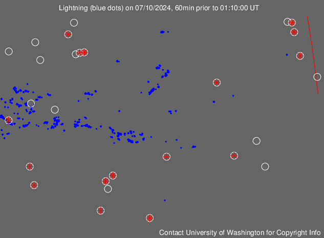