March 2010
Monthly Archive
Posted by Glenn
[3] Comments
March 31-April 1, 2010
Air Temperatures – The following maximum temperatures were recorded across the state of Hawaii Wednesday afternoon:
Lihue, Kauai – 79
Honolulu, Oahu – 83
Kaneohe, Oahu – 79
Kaunakakai, Molokai – 78
Kahului, Maui – 83
Hilo, Hawaii – 80
Kailua-kona – 82
Air Temperatures ranged between these warmest and coolest spots near sea level around the state – and on the highest mountains…at 4pm Wednesday afternoon:
Barking Sands, Kauai – 83F
Kapalua, Maui – 75
Haleakala Crater – 54 (near 10,000 feet on Maui)
Mauna Kea summit – 43 (near 14,000 feet on the Big Island)
Precipitation Totals – The following numbers represent the largest precipitation totals (inches) during the last 24 hours on each of the major islands, as of Wednesday afternoon:
0.37 Mount Waialaele, Kauai
0.31 Oahu Forest NWR, Oahu
0.06 Molokai
0.00 Lanai
0.00 Kahoolawe
0.15 West Wailuaiki, Maui
0.12 Kawainui Stream, Big Island
Marine Winds – Here’s the latest (automatically updated) weather map showing a 1031 millibar high pressure system located to the north of the islands. This pressure configuration will keep strong to very strong trade winds blowing Thursday…slightly lighter Friday.
Satellite and Radar Images: To view the cloud conditions we have here in Hawaii, please use the following satellite links, starting off with this Infrared Satellite Image of the islands to see all the clouds around the state during the day and night. This next image is one that gives close images of the islands only during the daytime hours, and is referred to as a Close-up visible image. This next image shows a larger view of the Pacific…giving perspective to the wider ranging cloud patterns in the Pacific Ocean. Finally, here’s a Looping IR satellite image, making viewable the clouds around the islands 24 hours a day. To help you keep track of where any showers may be around the islands, here’s the latest animated radar image.
Hawaii’s Mountains – Here’s a link to the live webcam on the summit of near 14,000 foot Mauna Kea on the Big Island of Hawaii. The tallest peak on the island of Maui is the Haleakala Crater, which is near 10,000 feet in elevation. These two webcams are available during the daylight hours here in the islands…and when there’s a big moon rising just after sunset for an hour or two! Plus, during the nights and early mornings you will be able to see stars, and the sunrise too…depending upon weather conditions.
Tropical Cyclone activity in the eastern and central Pacific – Here’s the latest weather information coming out of the National Hurricane Center, covering the eastern north Pacific. You can find the latest tropical cyclone information for the central north Pacific (where Hawaii is located) by clicking on this link to the Central Pacific Hurricane Center. Here’s a tracking map covering both the eastern and central Pacific Ocean. A satellite image, which shows the entire ocean area between Hawaii and the Mexican coast…can be found here.
Aloha Paragraphs

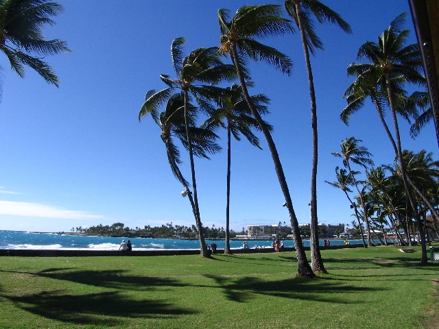
Windy weather to say the least!
There will be some fluctuations in the strength of the trade winds through the next week…although strong and gusty will be the name of the game for the most part. As I was mentioning down the page from here, the top gust so far, during this exceptionally windy period, was the outrageous 71 mph at Kaupo Gap…on the southeast side of east Maui! There have been many reports of 50+ mph gusts at several locations. The pressure gradient across our island chain remains tight, with a well established 1031 millibar high pressure system, positioned north of Hawaii Wednesday night, as shown on this weather map. Speaking of those fluctuations, it looks like Friday’s wind speeds will slip ever so slightly, and then again next Monday and Tuesday…otherwise, all kinds of windy weather will prevail through most of next week.
The reason for the slight softening of the winds coming up, is that a low pressure system, and its associated cold front, will migrate by to the north of our high pressure system Friday. This will erode the high pressure cell’s north side as it migrates by eastward. This slightly lighter version of the trade winds won’t last long, as a new high pressure system moves into place this weekend. This will jack the trade winds right back up across our area, before a second cold front moves by in the middle latitudes of the Pacific Ocean, slightly weakening our trade wind speeds a touch Monday and Tuesday. Then, yet another increase in our wind speeds will occur as a third high pressure system lines up to our north around next Wednesday…prompting another increase for several days.
We still have a ton of wind related advisories and warnings going on now…which will remain in force into Thursday. We continue to see an unusual wind advisory in effect over all the islands. At sea, at least over the coastal zones, a small craft wind advisory covers the entire state. In deeper water, in those major channels between the islands of Maui and Molokai, Maui and the Big Island, and to the south and west of the Big Island, we have another unusual feature…as gale warningd apply out there. All of these strong winds are of course blowing across the surrounding ocean too, and well upstream of our windward sides. Thus, we have a high surf advisory over the east facing shores, which is a rough and choppy affair. Perhaps by Friday, we may see a couple of these being dropped from the arsenal of NWS products.
Rainfall will be relatively scarce, as any showery clouds are being limited by several factors now. Very often we find wet clouds being carried into the windward sides of the islands…under such circumstances. This time around though, we have a very limited rainfall regime, at least for the time being. There will of course be some showers arriving, although not all that many. The windward sides will get the most, although some light showers may get carried over into the leeward sides on the smaller islands…during the windiest aspects this ongoing windy episode. The models have been describing some increase in showers for this weekend, and continuing into early next week. This would be a good thing, as we continue to have well below normal precipitation for this time of year...like near 25% of normal!
It’s Wednesday evening as I begin writing this last section of today’s narrative. Trade winds remain active across the islands now…to say the least. Looking at the strongest gusts around the state during the last 24 hours, these were the biggest numbers on each of the islands:
43 mph on Kauai
56 mph on Oahu
56 mph on Molokai
51 mph on Lanai
58 mph on Kahoolawe
71 mph on Maui
58 mph on the Big Island
It’s a little difficult to believe, although I absolutely trust the wind instruments (called anemometers), that the winds are actually this strong! 50+ mph gusts on all the islands from Oahu down through Maui County to the Big Island. The 70+ mph gust at Kaupo Gap, here on Maui, is incredible…very very unusual! This falls just 4 mph short of qualifying as hurricane force! One of the most remarkable things is to be in a place like Kihei, or Kula, Maui, and be almost totally in the wind shadow…of the near 10,000 foot Haleakala Crater. At lunch today here in Kihei, I was in a very light breeze, while I looked out over the ocean between Maui and Lanai, and could see very strong winds whipping-up the ocean like crazy! By the way, my automobile thermometer was reading 90F degrees at lunch today…that’s unofficial of course. My neighbors upcountry in Kula, said that there were generally light winds up there today as well. The direction of the winds are all important, with your exposure determining if you’re in the "wind tunnel" or not. I had a friend from Haiku, Maui (windward Maui) email me today, and told me she was having very strong and gusty trade winds in her area. ~~~ At near 515pm Wednesday evening, the strongest gusts in the state were being reported on both Maui and the Big Island…with 52 mph at PTA Kipuka Alala on the Big Island, and also Maalaea Bay, Maui. I had the Maui News call and interview me about the winds this afternoon, with the story coming out in Thursday’s paper. The reason I bring this up, is because my friend Brian Perry, the City Editor, told me that there was at least one brush fire reported in the Kaanapali area, which had scorched at least 10 acres so far. ~~~ I’m about ready to leave Kihei for my drive back to Kula now, and looking out the window of my office, I literally don’t see one cloud in the sky, it is toally clear again this evening, much like the last two evenings. I’ll be back with you again dark and early Thursday morning, with your next new weather narrative hot off the press…right here and now, I mean then. I hope you have a great Wednesday night! Aloha for now…Glenn.
Interesting: For all of you who enjoy syrupy pancakes, bacon, eggs, and sausage for breakfast; for all who crave omelets and pork-roll, egg and cheese sandwiches; for all who relish the breakfast of champions, there is some great news coming your way. According to a new study at the University of Alabama at Birmingham, eating a high fat breakfast is healthier than you think! Metabolic syndrome, the technical term for abdominal obesity, high triglycerides, insulin resistance, and other cardiovascular disease-risk factors, may actually be prevented from eating a high fat breakfast in the morning.
The study, titled "Time-of-day-dependent dietary fat consumption influences multiple cardio-metabolic syndrome parameters in mice," published in the International Journal of Obesity on March 30th may prove the old adage to eat breakfast like a king, lunch like a prince, and dinner like a pauper. "Studies have looked at the type and quantity of food intake," says the study’s lead author Molly Bray, Ph.D., "but nobody has undertaken the question of whether the timing of what you eat and when you eat it influences body weight."
Bray believes her research team has found that fat intake just after waking seems to make fat metabolism much more efficient, and increases the body’s ability to respond to different types of food later in the day. Therefore, your first meal determines your metabolism for the rest of the day. Using mice subjects, the team revealed that when the mice are fed a carbohydrate-rich breakfast, carbohydrate metabolism was turned up and seemed to stay at that level throughout the day, no matter what the mice were fed later on.
On the other hand, the consequences of a fat-rich breakfast is increased "metabolic plasticity to transfer your energy utilization between carbohydrate and fat," according to the study’s senior author, Martin Young, Ph.D. Since the human diet is so varied throughout the day, this flexibility becomes a significant advantage. However, before jumping for joy over this new bacon-loving freedom, it is important to note that this metabolic advantage only works in conjunction with low-caloric intake later in the day.
Only through the combination of the two can health benefits be seen. A high fat/carbohydrate meal at the end of the day would lead to weight gain and other obesity-related problems, no matter what was eaten for breakfast. The study concludes by stating that the time of day at which fat or carbohydrates are consumed significantly impacts the efficiency of the metabolic system. Therefore, the largest meal is better at the beginning rather than the end.
Interesting2: Magazines are being printed in volumes everyday, and the sheer bulk in waste is staggering. Time magazine prints more than four million copies a year, all in a slick glossy format that has not always been recyclable. But now, a technological gadget could provide a means for curbing the amount of glossy magazines that are produced—and therefore the number that end up in landfills.
Apple is bringing the iPad to the world on April 3rd, and as usual for Apple, it is being delivered with a lot of hoopla and plenty of pre-orders. However, this device is different from past debuts in that its strengths may not be the device itself, but rather the deals and the support surrounding it. To be more precise, Apple has been working with major publishers to bring their wares to the device.
As Information Week reports, Time and other major magazines will offer digital versions, served up on the device. Publishers are hoping the iPad will bring back declining readership and ad sales—and Time has already lined up Unilever, Toyota, and Fidelity Investments for ad space placement. The cost for an ad in an iPad issue? A cool $200,000.
One of the things attracting the print media giants is the iPad’s dynamic and colorful display, which will allow advertisements to really sing and transcend the printed page. You can expect to see interactive ads, incorporating user-generated and sport videos. These new ads should be a hit with young viewers, who have been exposed to interactive TV and video games for most of their lives.
Interesting3: Top a building with a light-colored "cool roof," and it reflects sunlight, cutting air conditioning bills in summer, but increasing winter heating costs. Choose black shingles, and the roof soaks up sunlight to cut winter heating costs but makes the roof bake in the summer sun. One or the other.
You can’t have it both ways. Until now. Scientists reported the development of a "smart" roof coating, made from waste cooking oil from fast food restaurants, that can "read" a thermometer. The coating automatically switches roles, reflecting or transmitting solar heat, when the outdoor temperature crosses a preset point that can be tuned to the local climate. They described the coating at the 239th National Meeting of the American Chemical Society (ACS) in San Francisco.
Roofs coated with the material would reflect scorching summer sunlight and reduce sticker-shock air-conditioning bills. When chilly weather sets in, the coating would change roles and transmit heat to help warm the interior. "This is one of the most innovative and practical roofing coating materials developed to date," said Ben Wen, Ph.D., leader of the research project. He is the vice-president of United Environment & Energy LLC in Horseheads, N.Y.
"This bio-based intelligent roof coating, compared with a traditional cool roof, could reduce both heating and cooling costs as it responds to the external environment. It will help save fuel and electricity and reduce emissions of volatile organic compounds from petroleum-based roofing products. In addition, it will provide a new use for millions of gallons of waste oil after it is used to cook french fries and chicken nuggets."
Scientists already have evidence that "white roofs" — roofs that are painted white to reflect solar heat and help cool buildings during peak summer weather — could significantly reduce global warming by lowering fuel consumption. However, white roofs can have a wintertime heating penalty because they reflect solar heat that would help warm the building. So white roofs are a benefit in summer but a detriment in winter.
The new "intelligent" coating may sidestep this quandry. Tests on coated asphalt shingles showed that it could reduce roof temperatures by about 50 — 80 percent in warm weather. In cooler weather, the coating could increase roof temperatures up to 80 percent compared with the traditional cool roof. By changing the coating’s composition, Wen and colleagues can tune the substance, so that it changes from reflective to transmitive at a specific environmental temperature.
"Even though the roof temperature is reduced or increased by a few degrees, depending on the outside temperature, this change could make a big difference in your energy bill," Wen noted. In producing the coating, waste cooking oil is processed into a liquid polymer that hardens into a plastic after application. Unlike raw waste oil, which can smell like French fries or fish, the resulting polymer is virtually odorless. Manufacturers could potentially produce it in any shade, ranging from clear to black, depending on what additives are used, he said.
The material is also non-flammable and nontoxic. Wen cautions against pouring ordinary cooking oil on a roof in an attempt to achieve a similar energy-saving effect. That’s because ordinary cooking oil won’t turn into a polymer, doesn’t contain the key ingredient for controlling infrared light levels, and could well pose a fire hazard for the building.
The coating can be applied to virtually any type of roof. Wen expects that the coating can last many years and can be reapplied when it wears off. If further testing continues to go well, he estimates that the coating could be ready for commercial use in about three years.
Interesting4: One of the most common house ant species might have been built for living in some of the smallest spaces in a forest, but the ants have found ways to take advantage of the comforts of city living. Grzegorz Buczkowski, a Purdue University research assistant professor of entomology, found that odorous house ant colonies become larger and more complex as they move from forest to city and act somewhat like an invasive species. The ants live about 50 to a colony with one queen in forest settings but explode into super-colonies with more than 6 million workers and 50,000 queens in urban areas.
"This is a native species that’s doing this," said Buczkowski, whose results are published in the early online version of the journal Biological Invasions. "Native ants are not supposed to become invasive. We don’t know of any other native ants that are out-competing other species of native ants like these." Odorous house ants live in hollow acorn shells in the forest. They’re called odorous because they have a coconut- or rum-like smell when crushed. They’re considered one of the most common house ants.
In semi-natural areas that are a cross of forest and urban areas, such as a park, Buczkowski said he observed colonies of about 500 workers with a single queen. He said it’s possible that as the ants get closer to urban areas they have easier access to food, shelter and other resources. "In the forest, they have to compete for food and nesting sites," Buczkowski said. "In the cities, they don’t have that competition. People give them a place to nest, a place to eat." Buczkowski observed the ants in three different settings on and around the Purdue campus.
He said it might be expected that if the odorous house ants were able to multiply into complex colonies, other ants would do the same. But Buczkowski found no evidence that other ants had adapted to new environments and evolved into larger groups as the odorous house ants have. He said it’s possible that odorous house ants are better adapted to city environments than other ant species or that they had somehow outcompeted or dominated other species.
"This raises a lot of questions we’d like to answer," he said. Buczkowski said understanding why the super-colonies form could lead to better control of the pests in homes, as well as ensuring that they don’t outcompete beneficial species. Future studies on odorous house ants will include studying the ant’s genetics and trying to understand the effects of urbanization of odorous house ants.
Interesting5: The main cause of a rapid global cooling period, known as the Big Freeze or Younger Dryas — which occurred nearly 13,000 years ago — has been identified thanks to the help of an academic at the University of Sheffield. A new paper, which is published in Nature on April 1, 2010, has identified a mega-flood path across North America which channelled melt-water from a giant ice sheet into the oceans and triggering the Younger Dryas cold snap.
The research team, which included Dr Mark Bateman from the University of Sheffield’s Department of Geography, discovered that a mega-flood, caused by the melting of the Laurentide ice sheet, which covered much of North America, was routed up into Canada and into the Arctic Ocean. This resulted in huge amounts of fresh water mixing with the salt water of the Arctic Ocean.
As a result, more sea-ice was created which flowed into the North Atlantic, causing the northward continuation of the Gulf Stream to shut down. Without the heat being brought across the Atlantic by the Gulf Stream, temperatures in Europe plunged from similar to what they are today, back to glacial temperatures with average winter temperatures of -25oC. This cooling event has become known as the Younger Dryas period with cold conditions lasting about 1400 years.
The cold of the Younger Dryas affected many places across the continent, including Yorkshire in the Vale of York and North Lincolnshire which became arctic deserts with sand dunes and no vegetation. Before now, scientists have speculated that the mega-flood was the main cause of the abrupt cooling period, but the path of the flood waters has long been debated and no convincing evidence had been found establishing a route from the ice-sheet to the North Atlantic.
The research team studied a large number of cliff sections along the Mackenzie Delta and examined the sediments within them. They found that many of the cliff sections showed evidence of sediment erosion. This evidence spanned over a large region at many altitudes, which could only be explained by a mega-flood from the over-spilling of Lake Agassiz, which was at times bigger than the UK, at the front of the Laurentide Ice-sheet rather than a normal flood of the river.
Dr Bateman, who has been researching past environmental changes both in the UK and elsewhere in the world for almost 20 years, runs the luminescence dating lab at Sheffield. The lab was able to take the MacKenzie Delta sediment samples from above and below the mega-flood deposits, and find out when the mega-flood occurred, enabling its occurrence to be attributed to the start of the Younger Dryas. The study will help shed light on the implications of fresh water input into the North Atlantic today.
There are current concerns that changes in the salinity of the ocean today, could cause another shut down of the Gulf Stream. Current climate changes, including global warming, may be altering the planetary system which regulates evaporation and precipitation, and moves fresh water around the globe.
The findings, which show the cause, location, timing and magnitude of the mega-flood, will enable scientists to better understand how sensitive both oceans and climates are to fresh-water inputs and the potential climate changes which may ensue if the North Atlantic continues to alter.
Posted by Glenn
[2] Comments
March 30-31, 2010
Air Temperatures – The following maximum temperatures were recorded across the state of Hawaii Tuesday afternoon:
Lihue, Kauai – 79
Honolulu, Oahu – 83
Kaneohe, Oahu – 79
Kaunakakai, Molokai – 78
Kahului, Maui – 82
Hilo, Hawaii – 80
Kailua-kona – 81
Air Temperatures ranged between these warmest and coolest spots near sea level around the state – and on the highest mountains…at 4pm Tuesday afternoon:
Kailua-kona – 82F
Princeville, Kauai – 75
Haleakala Crater – missing (near 10,000 feet on Maui)
Mauna Kea summit – 36 (near 14,000 feet on the Big Island)
Precipitation Totals – The following numbers represent the largest precipitation totals (inches) during the last 24 hours on each of the major islands, as of Tuesday afternoon:
0.48 Mount Waialaele, Kauai
0.20 Oahu Forest NWR, Oahu
0.00 Molokai
0.00 Lanai
0.00 Kahoolawe
0.03 Puu Kukui, Maui
0.37 Kawainui Stream, Big Island
Marine Winds – Here’s the latest (automatically updated) weather map showing a 1031 millibar high pressure system located to the north of the islands. This pressure configuration will keep strong to very strong trade winds blowing into mid-week…and beyond.
Satellite and Radar Images: To view the cloud conditions we have here in Hawaii, please use the following satellite links, starting off with this Infrared Satellite Image of the islands to see all the clouds around the state during the day and night. This next image is one that gives close images of the islands only during the daytime hours, and is referred to as a Close-up visible image. This next image shows a larger view of the Pacific…giving perspective to the wider ranging cloud patterns in the Pacific Ocean. Finally, here’s a Looping IR satellite image, making viewable the clouds around the islands 24 hours a day. To help you keep track of where any showers may be around the islands, here’s the latest animated radar image.
Hawaii’s Mountains – Here’s a link to the live webcam on the summit of near 14,000 foot Mauna Kea on the Big Island of Hawaii. The tallest peak on the island of Maui is the Haleakala Crater, which is near 10,000 feet in elevation. These two webcams are available during the daylight hours here in the islands…and when there’s a big moon rising just after sunset for an hour or two! Plus, during the nights and early mornings you will be able to see stars, and the sunrise too…depending upon weather conditions.
Tropical Cyclone activity in the eastern and central Pacific – Here’s the latest weather information coming out of the National Hurricane Center, covering the eastern north Pacific. You can find the latest tropical cyclone information for the central north Pacific (where Hawaii is located) by clicking on this link to the Central Pacific Hurricane Center. Here’s a tracking map covering both the eastern and central Pacific Ocean. A satellite image, which shows the entire ocean area between Hawaii and the Mexican coast…can be found here.
Aloha Paragraphs
Blustery weather continues into mid-week
As expected, and pointed out by the computer models since late last week, our trade winds have escalated into the strong and gusty realms. The gust factor of this blustery trade wind event has been notable, topping out, at least so far, at 67 mph at Kaupo Gap…on the southeast side of east Maui! As we know in reference, a hurricane has winds that exceed 74 mph. The big gust on Maui Tuesday morning missed that distinction by just eight miles per hour. There have been several reports of 50+ mph gusts, although as usual…sustained winds have been less strong. The pressure gradient across our island chain remains tight, with a well established 1030 millibar high pressure system, positioned north of Hawaii, as shown on this weather map. The strong flow of air is rushing across our tropical latitudes, on its way into the inter-tropical convergence zone (ITCZ), located just north of the equator…well to our south.
The latest computer forecast models show this high pressure center wobbling around to our north through the next couple of days. This will ensure that our exceptionally strong and gusty trade winds will remain in force for the time being. The computer models show a low pressure system, and its associated cold front, migrating by to the north of our high pressure system around Thursday. This will likely weaken the pressure gradient as it goes by, with a corresponding softening of our local wind speeds…although minimally. This slightly lighter version of the trade winds won’t last long, as a new high pressure system moves into position to our northwest and north this weekend. This will crank the trade winds right back up across our area, before a second cold front moves by in the middle latitudes of the Pacific Ocean, slightly weakening our trade wind speeds a touch Monday and Tuesday. Then, yet another increase in our wind speeds will occur as a third high pressure system lines up to our north around next Wednesday.
Besides just the wind, there will be other considerations to contend with during this prolonged windy regime. We’ve already seen an unusual wind advisory in effect over all the islands. At sea, at least over the coastal zones, a small craft wind advisory covers the entire state. In deeper water, in those major channels between the islands of Maui and Molokai, Maui and the Big Island, and to the south and west of the Big Island, we have another unusual feature…as a gale warning applies out there. The small craft wind advisories are common, although when we start to see wind advisories, and gale warnings…these grade into the more unusual side of the NWS arsenal of products. All of these strong winds are of course blowing across the surrounding ocean too, and well upstream of our windward sides as well. This fills the ocean surface with billions of white caps, in addition to swells and breaking waves along our beaches. Thus, we have a high surf advisory over the north and west facing beaches, as we have a large northwest swell occurring at the same time as these big winds are blowing. We have an advisory for the east facing shores too, which is a rough and choppy affair. If all of this wasn’t enough, we have a marine weather statement, for moderate surges in the Kahului and Hilo harbors, with potentially large breaking waves at the entrances of harbors.
So, what about precipitation, are we gonna get any? Very often we find wet clouds being carried into the windward sides of the islands…under such circumstances. This time it looks like a very limited rainfall regime, at least for the time being. There will of course be some showers arriving, although not all that many. The windward sides will get the most, although some light showers may get carried over into the leeward sides on the smaller islands…during the windiest aspects this ongoing windy episode. The models suggest that an upper level low pressure system will edge overhead later this weekend, into next week. This in turn could enhance our rainfall pattern, with more generous moisture getting into our area then. This is the time of year when we depend on, or at least hope…that the trade winds will bring us water, in order to get us through the often long dry summer months ahead. It’s still a bit too early to know for sure just how wet we may get beginning later Sunday, but we should all be looking forward to such an occurrence. As the information from the NWS shows below, we’re running short, very short of anything close to normal rainfall amounts thus far this year:
FOR JANUARY 2010 THROUGH THE END OF FEBRUARY – RAINFALL TOTAL ACCUMULATIONS WERE:
– LIHUEAIRPORT 2.00 INCHES (25 PERCENT OF NORMAL)
– HONOLULUAIRPORT 1.38 INCHES (27 PERCENT OF NORMAL)
– KAHULUIAIRPORT 1.61 INCHES (26 PERCENT OF NORMAL)
– HILOAIRPORT 2.32 INCHES (12 PERCENT OF NORMAL)
NCEP TOOLS PREDICT BELOW MEDIAN PRECIPITATION FOR HAWAII FOR APRIL 2010.
NCEP MODELS PREDICT BELOW NORMAL TEMPERATURE FOR HAWAII FOR APRIL 2010.
It’s Tuesday evening as I begin writing this last section of today’s narrative. Trade winds remain active across the islands now…to say the least. Looking at the strongest gusts around the state at near 5pm, these were the biggest numbers on each of the islands:
40 mph on Kauai
46 mph on Oahu
39 mph on Molokai
42 mph on Lanai
46 mph on Kahoolawe
50 mph on Maui
55 mph on the Big Island
As evidenced by the big numbers above, and after finding winds gusting up to 67 mph earlier Tuesday morning, the trade winds are still our headline weather news…as we head into Tuesday night and Wednesday. The flags are whipping straight out from their poles, dust is swirling around where there’s loose soil available, among numerous other wind sponsored happenings. It would be wise to drive carefully, not to mention take great care going out into the ocean now, what with the wind and seas so utterly rough in many places. ~~~ As I get ready to leave Kihei, on my way back upcountry to Kula, the whole west side of the Haleakala Crater is totally, absolutely cloud free! By the way, my neighbors mentioned it was near 80F degrees up at our property this afternoon, while down here near the ocean, my car thermometer was reading a very summery 89 degrees at lunch! I’ll be back with you early Wednesday morning, with what else – but more cutting edge information about this windy weather on the last day of March. I hope you have a great Tuesday night, made bright with the still large moon beaming down on us! Aloha for now…Glenn.
Interesting: In the Mediterranean Sea off the coast of Libya, there’s an area local fishermen call "Turtle Island." It’s real enough, but you’d be foolish to try to sail there. The island is never in precisely the same place, and it changes size from one minute to the next. In fact, you never know when its gleaming shore might disappear altogether, because it’s made up entirely of the half-exposed shells of basking loggerhead sea turtles.
The funny thing is, sea turtles, unlike the Mediterranean’s human denizens, aren’t supposed to like to float, says Sandra Hochscheid, a marine biologist at Stazione Zoologica Anton Dohrn in Naples, Italy. Scientists believe that loggerhead sea turtles (Caretta caretta), the dominant sea turtle in the Mediterranean, spend most of their lives underwater or on the sea floor, coming to the surface only for brief gasps of air.
"Everything we’d found out about turtles: feeding, mating, migrating, searching for good places, resting… has all taken place underwater," she says. Hochscheid knew about Turtle Island and had heard about basking turtles from tourists in Naples, but she’d never seen the behavior for herself. So she decided to figure out just what the loggerheads were doing spending so much time among the waves. "I’ve been looking 10 years into what they do under the water surface," Hochscheid says.
"But I’ve never looked at the time they spend at the surface." Hochscheid and colleagues collected 10 loggerheads from various locations in the Mediterranean and glued tracking devices—small black boxes with flexible antennas—to their shells. Over a year of observations, it became clear why the turtles had developed a reputation as bottom dwellers. The tagged loggerheads spent about 98% of their time underwater. And when they did come up, it was irregularly, sometimes twice in 2 days and sometimes not for a week.
Interesting2: The yearly ritual of severe heat and drought ahead of life-giving monsoon rains has kicked off earlier than usual over most of the Indian Subcontinent. As of Monday, average temperatures for the month thus far have been 5F to 10F above normal in a broad swath of eastern, central and northwestern India, as well as Pakistan and Bangladesh.
The upper end of this range has been reached along the thickly populated Indus River Valley between Karachi and Islamabad, Pakistan, and eastward into the desert of Rajasthan, the northwestern state of India. Highest temperature to about 110F have been reached this month from central Indian states of Chattisgarh, Maharashtra and Gujarat, west into Sindh, southern Pakistan.
An Indian rickshaw driver takes a nap in the afternoon heat in the Chandni Chowk neighborhood of New Delhi, India Friday, March 26, 2010. Coincident with the heat is serious drought over northwest India to much of Pakistan. This drought began last year with a rainfall dearth during the rain-giving summer monsoon. It has persisted through the present month on the back of deficient winter rains.
Heat and drought often work to perpetuate one another in a kind of reinforcing knock-on effect. In this light, and given that summer’s rains normally do not begin in earnest before July, sweltering heat and drought in Pakistan and northwest India are likely to persist indefinitely. Yields of winter crops have likely been trimmed by the ongoing drought. Looking forward, heat and drought will have continued impact in matters such as agriculture, water supply and personal comfort and health.
Interesting3: A new study involving scientists from 13 different organizations, universities and research institutions states that forest protection offers one of the most effective, practical, and immediate strategies to combat climate change. The study was published in PLoS Biology and makes specific recommendations for incorporating protected areas into overall strategies to reduce emissions of greenhouse gasses from deforestation and degradation (nicknamed REDD).
"Deforestation leads to about 15 percent of the world’s greenhouse gas emissions, more than all the cars, trucks, trains, ships, and planes on earth. If we fail to reduce it, we’ll fail to stabilize our climate," said Taylor Ricketts, director of World Wildlife Fund’s science program and lead author of the study.
"Our paper emphasizes that creating and strengthening indigenous lands and other protected areas can offer an effective means to cut emissions while garnering numerous additional benefits for local people and wildlife." The authors highlight analyses showing that since 2002, deforestation in the Brazilian Amazon has been 7 to 11 times lower inside of indigenous lands and other protected areas than elsewhere.
Simulation models suggest that protected areas established between 2003 and 2007 could prevent an estimated area of 100,000 square miles of deforestation through 2050. That is roughly the size of the state of Colorado, representing enough carbon to equal 1/3 of the world’s annual CO2 emissions. Within these efforts, location matters; protected areas in regions that face deforestation pressures would be most effective at truly reducing emissions.
"This study reinforces the wisdom behind global investments in protected areas," says Gustavo A.B. da Fonseca, co-author of the study and Team Leader Natural Resources of the Global Environment Facility (GEF). "In addition to protecting globally important species and ecosystems, the 2,302 protected areas supported by the GEF alone span over 634 million hectares and together store an impressive 30 billion tons of CO2"
Interesting4: Climate change might have helped bring about the fall of the ancient Khmer civilization in Angkor, Cambodia, nearly 600 years ago, new research suggests. Historians have given various explanations for the fall of the empire that stretched across much of Southeast Asia between the ninth and 14th centuries (801 to 1400), from land overexploitation to conflict with rival kingdoms.
But the new study offers strong evidence that two severe droughts, punctuated by bouts of heavy monsoon rain, could have weakened the empire by shrinking water supplies for drinking and agriculture, and damaging Angkor’s vast irrigation system, which was central to its economy. The kingdom, one of the greatest civilizations of all time, is thought to have collapsed in 1431 after a raid by the Siamese from present-day Thailand.
"Angkor at that time faced a number of problems — social, political and cultural. Environmental change pushed the ancient Khmers to the limit and they weren’t able to adapt," said study author Brendan Buckley, a climate scientist at Columbia University’s Lamont-Doherty Earth Observatory in New York. "I wouldn’t say climate caused the collapse, but a 30-year drought had to have had an impact."
The researchers were able to reconstruct 759 years of past climate in the region surrounding Angkor by studying the annual growth rings of cypress trees in a nearby national park. The tree rings revealed evidence of a mega-drought lasting three decades — from the 1330s to 1360s — followed by a more severe but shorter drought from the 1400s to 1420s, right before the empire collapse.
The droughts could have led to crop failure and a rise in infectious disease, and both problems would have been exacerbated by the density of the population, Buckley said. They also found evidence for intense rainy seasons that might have damaged Angkor’s hydraulic system. During a normal monsoon season, Angkor’s vast network of canals, embankments and reservoirs could have handled heavy downpours, but after extended droughts, the system may have been vulnerable to clogging.
The researchers suspect that El Niño, a cyclical warming of the tropical Pacific Ocean, might have played an important role in shutting down the monsoon rains in this region, leading to droughts. "The evidence from monsoon Asia should remind us that complex civilizations are still quite vulnerable to climate variability and change," said study researcher Kevin Anchukaitis, also of Columbia University.
Similar studies suggest that abrupt environmental changes may have pushed other ancient civilizations over the edge, including the Anasazi people of the southwestern United States; the Maya people of Central America; and the Akkadian people of Mesopotamia. The results were published this week in the journal Proceedings of the National Academy of Sciences.
Posted by Glenn
[3] Comments
March 29-30, 2010
Air Temperatures – The following maximum temperatures were recorded across the state of Hawaii Monday afternoon:
Lihue, Kauai – 78
Honolulu, Oahu – 79
Kaneohe, Oahu – 78
Kaunakakai, Molokai – 79
Kahului, Maui – 82
Hilo, Hawaii – 79
Kailua-kona – 81
Air Temperatures ranged between these warmest and coolest spots near sea level around the state – and on the highest mountains…at 5pm Monday evening:
Barking Sands, Kauai – 81F
Lihue, Kauai – 71
Haleakala Crater – 48 (near 10,000 feet on Maui)
Mauna Kea summit – 39 (near 14,000 feet on the Big Island)
Precipitation Totals – The following numbers represent the largest precipitation totals (inches) during the last 24 hours on each of the major islands, as of Monday afternoon:
0.82 Mount Waialaele, Kauai
0.31 South Fork Kaukonahua, Oahu
0.02 Molokai
0.00 Lanai
0.00 Kahoolawe
1.23 Puu Kukui, Maui
0.59 Kawainui Stream, Big Island
Marine Winds – Here’s the latest (automatically updated) weather map showing a 1031 millibar high pressure system located to the north of the islands. This pressure configuration will cause increasingly strong trade wind speeds Tuesday into mid-week.
Satellite and Radar Images: To view the cloud conditions we have here in Hawaii, please use the following satellite links, starting off with this Infrared Satellite Image of the islands to see all the clouds around the state during the day and night. This next image is one that gives close images of the islands only during the daytime hours, and is referred to as a Close-up visible image. This next image shows a larger view of the Pacific…giving perspective to the wider ranging cloud patterns in the Pacific Ocean. Finally, here’s a Looping IR satellite image, making viewable the clouds around the islands 24 hours a day. To help you keep track of where any showers may be around the islands, here’s the latest animated radar image.
Hawaii’s Mountains – Here’s a link to the live webcam on the summit of near 14,000 foot Mauna Kea on the Big Island of Hawaii. The tallest peak on the island of Maui is the Haleakala Crater, which is near 10,000 feet in elevation. These two webcams are available during the daylight hours here in the islands…and when there’s a big moon rising just after sunset for an hour or two! Plus, during the nights and early mornings you will be able to see stars, and the sunrise too…depending upon weather conditions.
Tropical Cyclone activity in the eastern and central Pacific – Here’s the latest weather information coming out of the National Hurricane Center, covering the eastern north Pacific. You can find the latest tropical cyclone information for the central north Pacific (where Hawaii is located) by clicking on this link to the Central Pacific Hurricane Center. Here’s a tracking map covering both the eastern and central Pacific Ocean. A satellite image, which shows the entire ocean area between Hawaii and the Mexican coast…can be found here.
Aloha Paragraphs

Exceptionally windy in many areas now
The primary influence in the Hawaiian Islands now is by far the strong and gusty trade wind flow, buffeting areas from sea level…on up to at least 10,000 feet in elevation. The source of all this blustery weather is the high pressure system, rated at 1031 millibars…as shown to the north of Kauai on this weather map. This trade wind producing high pressure cell is moving eastward, and will remain in a favorable location to spin out stronger than normal trade winds through most of the rest of this week. The computer models show another high pressure system moving into position, to our northwest and north towards the weekend. This will likely trigger a second blustery period of trade winds as we move into early next week.
Small craft wind advisories are up across the entire state now, at least in those coastal waters going into Monday night. As the winds have increased today, we now have gale warnings across the windy channels around Maui and the Big Island as well. At the same time, we already have a wind advisory atop the Haleakala Crater on Maui…which is now been extended to cover all the islands into Tuesday…which is very unusual! Winds, as shown in the list below, are already gusting well up into the 30 mph plus range, with some of the windiest places finding gusts topping 40 mph. At least one place, the small island of Kahoolawe has seen winds gusting up to the 50 mph mark! We will very likely see more of this kind of thing over the next few days, perhaps into Thursday even.
As far as rainfall goes, most of it will be deposited by the trade winds along the windward coasts and slopes, with a few showers perhaps flying over the lower mountains on the smaller islands…into the leeward sides. Typically, showers are quite abundant during such gusty trade wind episodes. This time around though, there should be somewhat limited precipitation, although passing showers at times nonetheless. Meanwhile, this satellite image shows a rather extensive amount of high cirrus clouds just to the west of the islands. This area has been nearly stationary for the last several days. It looks like it is getting ready to move closer on the upper winds aloft. The lower level clouds, as seen on this closer IR satellite picture…shows just scattered clouds upstream. By the way, a fire weather watch is now in effect through Wednesday evening, due to the gusty winds, low relative humidity, and ample dry fuel…on the leeward sides.
It’s Monday evening as I begin writing this last section of today’s narrative. Trade winds remain active across the islands now. Looking at the strongest gusts around the state at near 5pm, these were the highest on each of the islands:
32 mph at Lihue, Kauai
48 mph at Oahu Forest NWR
38 mph on Molokai
42 mph on Lanai
50 mph on Kahoolawe
46 mph at Kaupo Gap, Maui
44 mph at Waikola, Big Island
As we can see, these gusts are all at 30 mph or over…and actually are mostly over 40 mph later in the day Monday. I would expect these strongest gusts to top 50 mph as we move into Tuesday and potentially Wednesday too. As noted in the paragraph above, these strong winds, coupled with the relatively dry relative humidities, and lots of bone dry fuel along the windward sides, spell the danger from brush fires – thus the current fire weather watch. This windy episode will be the main feature in our Hawaiian Island weather picture through this week, and right on into next week as well. The spring months here in the islands are well known to be filled with trade winds. All this rushing air, as it passes over the ocean surface, will cause millions of white caps. Thus, we expect rough and choppy ocean conditions, be careful when heading out to sea under these circumstances. The surf will be large enough over the next day or two, that we now have high surf advisory flags having gone up along our east facing shores, and our northwest shores too. ~~~ It’s about 530pm here in Kihei, Maui, as I get ready to head back upcountry to Kula. By the way, have you been noticing the large near full moon lately? You’ll be able to see it Monday night into Tuesday morning, when it will be at its fullest aspect, I’ll sure be checking it out with you! Looking up towards the Haleakala Crater before I take the drive back home, its mostly clear, with just a few minor clouds. It wouldn’t surprise me to see some color in our sky at sunset, what with those high cirrus clouds over the ocean to our west. I’ll catch up with you again early Tuesday morning, when I’ll be back with your next new weather narrative from windy Hawaii! Aloha for now…Glenn.
Interesting: Starved and emaciated, sea lion pups are beaching themselves along the Pacific Coast. A strong El Nino tropical weather pattern is to blame. Unusually warm sea surface temperatures in the western Pacific are moving east, forcing the sea lions’ natural food sources — squid, hake, herring and anchovies — to seek out cooler waters.
Adult sea lions have enough fat stored up to survive the resulting food shortage, but their pups aren’t so well-equipped. Richard Evans, medical director of the Pacific Marine Mammal Center in Laguna Beach, Calif., tells NPR’s Guy Raz that by the time the animals get to his team, they’re in the third stage of starvation.
"We stage starvation in humans and animals: one, two, three. Three is when you’ve gone so bad that you start digesting your muscle as a source of protein." The Pacific Marine Mammal Center rescues and nurses starving sea lions back to health, and then releases them back into the sea. Scientists at the center started seeing an increase in starving sea lion pups last spring.
The center sees sick animals all the time, but not usually this severe. The pups began coming in so sick that it took much longer to nurse them back to health — up to six months instead of the usual two or three. Officials at the center soon learned that there had been an El Nino in the Pacific beginning in April. "It had taken its toll on the breeding colonies," Evans says. In addition to the food shortage, some sea lion mothers may have decided to stop nursing their pups in order to survive themselves.
Interesting2: A severe winter has left 4.5 million dead animals in stockyards across the Mongolian steppes, and many poor herders face the loss of all their property just before the important breeding season. About a tenth of Mongolia’s livestock may have perished, as deep snows cut off access to grazing and fodder. The damage to the rural economy could increase demands on Mongolia’s already-stretched national budget, which relies on mining revenues to meet spending commitments.
The Red Cross launched an emergency appeal for 1 million Swiss francs to assist Mongolian herders, after it estimated that 4.5 million livestock have died in the country since December. "The numbers of livestock that have perished have gone up very, very quickly and dramatically now to about 4 million which is roughly a tenth of the whole livestock population," Francis Markus, communications director for the Red Cross’ East Asia delegation, said in Beijing after returning from Mongolia.
"This means that thousands of families, mostly coming from the poorest and most vulnerable layers of the herder population, have lost their entire flocks of animals and have been left in a very, very distraught and very, very desperate state." Roughly one-quarter of Mongolia’s 3 million people are nomads, while others also raise livestock in fixed settlements.
Many go deeply in debt to buy and raise their herds, in hopes of making the money back by selling wool, meat and skins. A similar combination of a summer drought, followed by heavy snow and low winter temperatures, which is known in Mongolian as a ‘zud’, caused widespread hardship in Mongolia a decade ago. As a result, impoverished herder families flocked to the slums outside the capital, Ulan Bator, straining the city’s ability to provide basic services.
Interesting3: Once upon a time a trip around the world made major headlines. Nowadays it is common place and a convenient way to measure air quality around the world by plane. A plane outfitted to measure greenhouse gases has taken off from Colorado on the first leg of a 24 day mission that will take it back and forth across the Pacific Ocean from the Arctic to the Antarctic.
The mission is part of a three year project designed to determine when and where the gases enter and leave the atmosphere. That in turn could help policymakers as well as scientists on how to handle and measure climate change. The scientific questions that this study is focused on are (1) understanding the global sources and sinks for CO2, CH4, and other carbon cycle gases, and more broadly (2) determining large scale rates of tracer transport in the atmosphere.
In other words what are the seasonal ups and downs of these gases and where do they increase (sources) and where do they decrease (sinks). The largest known carbon dioxide sink is the ocean where about a quarter of the world supply of this gas is absorbed. Sources are both biological (animal) and fossil fuels. The three year campaign relies on the powerful capabilities of a specially equipped Gulfstream V aircraft.
The jet, known as the High performance Instrumented Airborne Platform for Environmental Research (HIAPER), has a range of about 7,000 miles, which allows scientists to traverse large regions of the Pacific Ocean without refueling, gathering air samples along the way. Researchers will take the jet from an altitude of 1,000 feet above Earth’s surface up to as high as 47,000 feet into the lower stratosphere. How carbon dioxide and methane gases vary by altitude will be determined.
Mapping air quality has been done before but not on a world level. For example NASA has funded maps on Carbon Dioxide air emissions are available of the US on a state by state level. Satellites have also been used to get a general range of some pollutants such as Nitrogen Dioxide in the troposphere as measured by SCIAMACHY Envisat. It can also measured with numerous ground based instruments and the data correlated and combined.
This is done by EPA for Ozone and Hazardous Air Pollutants such as Benzene for evaluating regional air quality. The present air borne study (the third of five) recently started from Anchorage, it will fly over the northern polar region, then to Hawaii, Fiji, New Zealand and the southern polar region before retracing its path to Alaska and returning to Colorado in mid-April.
"Previous experiments only can do like one fixed station, and with the aircraft you can actually fly and do vertical profiles of the gases you are measuring," said Vidal Salazar, project manager. "It’s the best and the latest." The missions are scheduled for different seasons to cover a range of conditions. Previous missions were in January and October 2009. The plane carries a 10 person research team along with cameras and instruments attached to the underside of each wing.
Interesting4: The economic growth in much of Asia has been quite remarkable in the last few decades. Unfortunately, along with growth comes intense pollution and atmospheric degradation. Pollutants from the region are being carried upward into the stratosphere during the monsoon season. Findings from a new study conducted by scientists at the National Center for Atmospheric Research (NCAR) provide evidence of the global nature of this atmospheric phenomenon.
The study was published Thursday, March 25, 2010 in Science Express, and was funded by the National Science Foundation with help from NASA and the Canadian Space Agency. Satellite observations and data modeling were used to determine the circulation properties associated with the Asian monsoon season.
"The monsoon is one of the most powerful atmospheric circulation systems on the planet, and it happens to form right over a heavily polluted region," says the lead author of the study, NCAR scientist William Randel. During the monsoon, air is transported upward into the stratosphere, about 20-25 miles above sea level.
This rapid movement of air provides a pathway for pollutants such as black carbon, sulfur dioxide (SO2), nitrogen oxides (NOx), and many others. Once at that level, the pollutants can circulate the globe for several years before returning to lower levels or breaking apart. It is difficult to predict the future of this global pollutant transport system. Increased industrial activity in Asia would increase the stratospheric damage. Also climate change has the potential to alter the monsoon season.
However, whether it would increase or decrease the upward flow of air remains uncertain. The effects of industrial pollutants in the stratosphere warrants further research. Sulfur-dioxide is known to affect the ozone layer by converting into compounds known as aerosols. Other chemicals may affect global climate by altering the amount of solar heat that reaches the planet surface.
Interesting5: The severe epidemic of plague known as the "Black Death" caused the death of a third of the European population in the 14th century. It is probable that the climatic conditions of the time were a contributory factor towards the disaster. "The late Middle Ages were unique from the point of view of climate," explains Dr Ulf Büntgen of the Swiss Federal Institute for Forest, Snow and Landscape Research (WSL) in Birmensdorf, Switzerland.
"Significantly, there were distinct phases in which summers were wetter than they are today." What exactly took place at the time can be reconstructed today by studying the annual growth rings of old oak trees. "Annual growth rings provide us with an accurate indication of summer droughts for each individual year, dating back to late medieval times," adds Professor Dr Jan Esper of the Johannes Gutenberg University Mainz.
Together with colleagues at the universities of Bonn, Gießen, and Göttingen, Büntgen and Esser managed, with the aid of the information provided by tree growth rings, to identify for the first time the summer drought periods over extensive areas of Germany in the last 1000 years. Their results have been published in the leading specialist journal Quaternary Science Reviews.
Using dendrochronology, the researchers have been able to demonstrate, for example, that a ridge beam in an old timber-framed house in the city of Kassel must have come from a tree felled in 1439. In this technique, the pattern of annual growth rings is compared with those in already dated wood samples. "We can thus determine the exact age of every beam," says Büntgen, describing the process. The ridge beam can also provide information on whether past summers in Kassel were wet or dry.
"If a summer tended to be wet, the trees generally grew faster, thus resulting in wider growth rings," Esper explains. However, the information available from one beam is not enough to allow reliable conclusions about the climate in Kassel in 1439 to be reached. A large number of wood samples are required. For their survey the researchers analyzed 953 different pieces of oak. To obtain information on the more recent past, they took wood from living trees.
They also took samples from wooden construction elements of old timber-framed houses, castles, and churches, thus roughly covering the period of the last 1000 years. All construction wood samples were obtained in the north of the German state of Hesse and the south of Lower Saxony, while the living wood came from the region of the Kellerwald-Edersee National Park. "Oak trees in this area are particularly sensitive to climate change," states Büntgen, explaining why these sites were selected.
The oldest wood sample used in this survey dates back to the year 996 A.D., a time when the Holy Roman Empire was just coming into being. A total of 135,000 individual growth rings were measured to obtain a detailed overview of the history of rainfall in Germany, covering major eras ranging from the optimal Medieval climate (warm and humid) through the Little Ice Age (dry and cold) to that of the Industrial Climate Change (dry and warm).
Posted by Glenn
No Comments
March 28-29, 2010
Air Temperatures – The following maximum temperatures were recorded across the state of Hawaii Sunday afternoon:
Lihue, Kauai – 78
Honolulu, Oahu – 83
Kaneohe, Oahu – 79
Kaunakakai, Molokai – 78
Kahului, Maui – 82
Hilo, Hawaii – 80
Kailua-kona – 82
Air Temperatures ranged between these warmest and coolest spots near sea level around the state – and on the highest mountains…at 5pm Sunday evening:
Kawaihae, Big Island – 82F
Molokai airport – 74
Haleakala Crater – 52 (near 10,000 feet on Maui)
Mauna Kea summit – 41 (near 14,000 feet on the Big Island)
Precipitation Totals – The following numbers represent the largest precipitation totals (inches) during the last 24 hours on each of the major islands, as of Sunday afternoon:
0.69 Mount Waialaele, Kauai
0.16 Manoa Valley, Oahu
0.03 Molokai
0.01 Lanai
0.21 Kahoolawe
0.46 Puu Kukui, Maui
0.31 Kawainui Stream, Big Island
Marine Winds – Here’s the latest (automatically updated) weather map showing a 1025 millibar high pressure system located far to the east-northeast, and another 1025 millibar high to the north-northwest of the Hawaiian Islands. This pressure configuration will cause an increase in trade wind speeds Monday and Tuesday.
Satellite and Radar Images: To view the cloud conditions we have here in Hawaii, please use the following satellite links, starting off with this Infrared Satellite Image of the islands to see all the clouds around the state during the day and night. This next image is one that gives close images of the islands only during the daytime hours, and is referred to as a Close-up visible image. This next image shows a larger view of the Pacific…giving perspective to the wider ranging cloud patterns in the Pacific Ocean. Finally, here’s a Looping IR satellite image, making viewable the clouds around the islands 24 hours a day. To help you keep track of where any showers may be around the islands, here’s the latest animated radar image.
Hawaii’s Mountains – Here’s a link to the live webcam on the summit of near 14,000 foot Mauna Kea on the Big Island of Hawaii. The tallest peak on the island of Maui is the Haleakala Crater, which is near 10,000 feet in elevation. These two webcams are available during the daylight hours here in the islands…and when there’s a big moon rising just after sunset for an hour or two! Plus, during the nights and early mornings you will be able to see stars, and the sunrise too…depending upon weather conditions.
Tropical Cyclone activity in the eastern and central Pacific – Here’s the latest weather information coming out of the National Hurricane Center, covering the eastern north Pacific. You can find the latest tropical cyclone information for the central north Pacific (where Hawaii is located) by clicking on this link to the Central Pacific Hurricane Center. Here’s a tracking map covering both the eastern and central Pacific Ocean. A satellite image, which shows the entire ocean area between Hawaii and the Mexican coast…can be found here.
Aloha Paragraphs

Molokai…sea cliffs
Our trade winds will gradually become stronger and gusty now through mid-week. Already our trade winds are beginning to increase in strength…a little earlier than previously throught. As these trades pick up, we may very well see wind advisories going up here and there over the islands…and even gale warnings in the major channels around Maui and the Big Island for a few days. This will of course be in addition to small craft wind advisories across all Hawaiian coastal waters…which have already gone up in all the marine zones from Kauai down through the Big Island Sunday evening. The models go on to show a cold front passing by to our north later in the new week, which should work to mellow-out the strong winds a little after by Friday. The computer model output then shows that the strong and gusty trade winds may return again next weekend into the following week.
The windward sides will continue to see some generally light showers falling at times…while the leeward sides remain dry. A high pressure ridge aloft, and to the north of the state, will shield us from any significant areas of precipitation well into the future. Looking at this satellite imagery, there are below normal amounts of clouds upstream of the islands, being carried our way on the trade wind flow. There are areas of high clouds (those brighter white clouds) in just about every direction, although none where spreading over the islands moving into Sunday night. This looping radar image shows that there are very few showers moving through the island chain at the time of this writing.
It’s Sunday evening as I begin writing this last section of today’s narrative. Trade winds remain active across the islands this evening. Looking at the strongest gusts around the state at around 5pm, as usual the strongest was occurring at Maalaea Bay, Maui…with 37 mph report, with 35 mph at the Kahului, Maui airport. The rest of the state had lighter winds, although stronger than they have been the last few days. We should find moderately strong trade winds blowing in most areas tonight, although as we can see, some of those windier areas are already beginning to get closer to 40 mph now. ~~~ The big news will be the substantially stronger trade winds arriving between Monday and Wednesday into Thursday. I would anticipate that wind speeds will be active in the 15-30 mph range in general, although with gusts in those windiest areas topping 40 mph…and perhaps edging up towards 50 mph at times! These are the kinds of winds that require some battening down of the hatches, in terms of securing lawn furniture and things like that. Dust will be flying around, the coconut palm trees will be leaning over, and of course the surface of the ocean will be filled with extensive white caps. ~~~ Sunday was a great day here in the islands, although as expected the winds are beginning to increase noticeably. By the way, the dry weather, with the gusty trade winds now, in addition to the dry fuel in the leeward sections…has triggered a red flag warning beginning soon. This simply means that here are dangerous conditions ripe for fires starting now. Here in Kula, Maui, it’s nearly calm, with an air temperature of a pleasant 68.5F degrees at around 530pm. The sun has been in and out of the clouds, which has been supportive of my getting lots of things ready for the new work work. I’m about ready to go down and prepare my red pasta sauce now, and then taking a nice walk before dinner. I’ll be back early Monday morning with your next new weather narrative. It’s been so great to have three days off from work, due to the Prince Kuhio Day this past Friday. This coming week, what with the Easter holidays, there will be another three day holiday period too. I hope you have a great Sunday night, and that we can meet here again then! Aloha for now…Glenn.
Interesting: The Asian monsoon spreads industrial pollution from China and India around the world by lofting it high into the atmosphere where it may affect the global climate, a study showed. "This is a vivid example of pollutants altering our atmosphere in subtle and far-reaching ways," said William Randel of the U.S. National Center for Atmospheric Research, who led the study in the journal Science.
It said the mid-year Asian monsoon sucks pollutants — such as black carbon, sulphur dioxide and nitrogen oxides — from the earth’s surface into the stratosphere about 20 to 25 miles high. Strong stratospheric winds then spread fast-growing amounts of pollution from countries such as China, India and Indonesia around the planet, where it can linger for years before falling to earth or breaking down.
"It’s as if there’s a hole that sucks the pollution from the ground and rapidly injects it into the lower stratosphere," said Professor Peter Bernath of the University of York in England who was among the authors. "People suspected it before but this shows that it happens," he told Reuters of the finding by researchers in Canada, Britain and the United States.
It was unclear what impact the Asian stratospheric pollution might have on the climate. Some particles could have a cooling effect by reflecting sunshine back into space while others might trap heat. "Overall you don’t know which way it could go," Bernath said. And pollution might also affect the ozone layer, which protects the planet from harmful ultraviolet rays.
Some scientists have proposed short-cut solutions to climate change known as geo-engineering — among them schemes to dim sunlight by spewing sulphur dioxide high into the atmosphere. Others say it is too risky, with possible damaging side effects. In the past, volcanoes have been shown to spew particles into the stratosphere and giant forest fires can also have the same impact.
But industrial pollution has been typically viewed as a local problem, low in the atmosphere. The study said a projected rise in economic growth, including the opening of many coal-fired power plants in China and India, could mean more pollution sucked up and spread by the Asian monsoon.
Climate change, blamed mainly on a build-up of heat-trapping carbon dioxide in the atmosphere, might also alter the monsoon alongside other impacts projected by the U.N. panel of climate scientists such as droughts, floods and rising sea levels. The researchers used satellites to monitor hydrogen cyanide — largely released from burning trees and other vegetation. Flows of hydrogen cyanide exposed how air currents were wafting pollution upwards.
Interesting2: What has been called the worst drought for China’s Yunnan Province in nearly a century will persist, as there is little prospect for meaningful rainfall until May. Between six and seven months of dry winter weather is characteristic of the Yunnan Province of China, but an early end to last year’s rainy season is causing the current drought to be much worse than in previous years.
A villager drives a bullock cart across a dried-up pond in Luliang, in southwest China’s Yunnan province, Monday, March 22, 2010. The worst drought in decades in China’s southern provinces of Yunnan, Guizhou, and Sichuan, as well as the Guangxi Autonomous Region and the city of Chongqing, has forced local governments to tap underground water sources and use cloud seeding to produce rain for agricultural production.
Yunnan has felt unusually high temperatures and unusually low rainfall since the beginning of September, when conditions usually dry out for the start of the winter’s dry season. May is expected to be the first month for heavier rainfall, when 4 inches is normal for the region during this time. The seasonal rainy weather usually begins in April or May for the province, with the dry season moving in after October.
The peak month of the rainy season is July, when over 8 inches of rain is normal. The drought is badly affecting the planting of crops, and reservoirs in serious shortage of water will make it even harder for planting to be sustained. The first round of crops this year failed, but there are hopes for a successful summer corn crop.
BBC estimated that over 50 million people in the province have been affected by the water shortage, deepening the poverty there. The dry conditions are being felt as far away as Beijing, where the first big dust storm of the season shrouded the city in orange grit last weekend.
Interesting3: The yellow haze descended across Nigeria, blotting out the sun, canceling airline flights and coating everything with a fine layer of dust. The sudden storm sparked frightened text messages about supposedly killer acid rain, but meteorologists say the weather comes from the harmattan, a yearly trade wind that brings dust from the Sahara Desert through Nigeria and the rest of West Africa.
This year, however, the harmattan has come at an abnormal time, a possible result of global warming. Experts say it may delay the rainy season in Africa’s most populous nation and there are worries it may even throw off future seasonal changes. "It is part of the changes of the climate," said Temi Ologunorisa, a professor of climatology at Osun State University. "With the coming of this dust, you cannot have rain."
The harmattan, caused by shifting weather patterns, means "tears your breath apart" in Twi, a West African language. The harmattan season typically begins in late November, as Nigeria’s dry season begins to end. The winds carry the sands and dust of the Sahara southward, and pick up the loose crop soil of Nigeria’s arid northern Sahel with it. This year, the harmattan briefly appeared in January.
It typically ends by February, said Sampson Wilson, a deputy general manager at the government-run Nigerian Meteorological Agency. But it blew back into Nigeria without warning last weekend, first enveloping the country’s north in dust and dropping visibility to almost zero, according to Wilson, and forcing many airlines to cancel flights in the country of 150 million people.
As it reached south, the storm encased the megacity of Lagos in a yellow fog that made the setting sun give off no more light than the moon. Northern Nigeria is experiencing growing desertification as rising temperatures allow the edge of the Sahara Desert to creep closer to the country. That additional dust adds fuel for the harmattan winds, said Ologunorisa, an expert on climate change.
"The more dust you have, it shows we have more desertification," he said. The harmattan has made it hard to breathe in Lagos, whose air already is polluted by swarms of beat-up cars navigating potholed streets and by electrical generators that provide power during frequent blackouts. Health authorities warned the public to cover faces with wet cloth and stay indoors, but many had to take to the streets to earn a living in a country where most live on less than $1 a day.
Doctors expected the late harmattan to bring colds, flu and asthma attacks, as the kicked-up dust in the air inflames lungs and nostrils. Changing patterns in the trade winds also affect when the harmattan will arrive, Ologunorisa said. The disruption of those patterns throws off Nigeria’s rainy and dry seasons as well — timing long relied on by farmers to know when to plant across the country’s fertile middle belt. Forecasters predict this harmattan will slowly lift across the country in the coming week. But fears over Nigeria’s changing weather patterns will linger.
Posted by Glenn
No Comments
March 27-28, 2010
Air Temperatures – The following maximum temperatures were recorded across the state of Hawaii Saturday afternoon:
Lihue, Kauai – 78
Honolulu, Oahu – 82
Kaneohe, Oahu – 79
Kaunakakai, Molokai – 75
Kahului, Maui – 80
Hilo, Hawaii – 79
Kailua-kona – 82
Air Temperatures ranged between these warmest and coolest spots near sea level around the state – and on the highest mountains…at 4pm Saturday afternoon:
Barking Sands, Kauai – 81F
Kapalua, Maui – 73
Haleakala Crater – 57 (near 10,000 feet on Maui)
Mauna Kea summit – 43 (near 14,000 feet on the Big Island)
Precipitation Totals – The following numbers represent the largest precipitation totals (inches) during the last 24 hours on each of the major islands, as of Saturday afternoon:
0.02 Mount Waialaele, Kauai
0.03 Oahu Forest NWR , Oahu
0.03 Molokai
0.03 Lanai
0.00 Kahoolawe
0.67 West Wailuaiki, Maui
0.50 Kawainui Stream, Big Island
Marine Winds – Here’s the latest (automatically updated) weather map showing a 1024 millibar high pressure system located far to the northeast, and another 1025 millibar high to the northwest of the Hawaiian Islands. At the same time, a cold front is moving by to the north of the state. This pressure configuration will keep light to moderately strong trade winds blowing Sunday...increasing Monday.
Satellite and Radar Images: To view the cloud conditions we have here in Hawaii, please use the following satellite links, starting off with this Infrared Satellite Image of the islands to see all the clouds around the state during the day and night. This next image is one that gives close images of the islands only during the daytime hours, and is referred to as a Close-up visible image. This next image shows a larger view of the Pacific…giving perspective to the wider ranging cloud patterns in the Pacific Ocean. Finally, here’s a Looping IR satellite image, making viewable the clouds around the islands 24 hours a day. To help you keep track of where any showers may be around the islands, here’s the latest animated radar image.
Hawaii’s Mountains – Here’s a link to the live webcam on the summit of near 14,000 foot Mauna Kea on the Big Island of Hawaii. The tallest peak on the island of Maui is the Haleakala Crater, which is near 10,000 feet in elevation. These two webcams are available during the daylight hours here in the islands…and when there’s a big moon rising just after sunset for an hour or two! Plus, during the nights and early mornings you will be able to see stars, and the sunrise too…depending upon weather conditions.
Tropical Cyclone activity in the eastern and central Pacific – Here’s the latest weather information coming out of the National Hurricane Center, covering the eastern north Pacific. You can find the latest tropical cyclone information for the central north Pacific (where Hawaii is located) by clicking on this link to the Central Pacific Hurricane Center. Here’s a tracking map covering both the eastern and central Pacific Ocean. A satellite image, which shows the entire ocean area between Hawaii and the Mexican coast…can be found here.
Aloha Paragraphs

Sea Turtle…black sand beach on the Big Island
High pressure systems located far to the northeast and northwest, will keep our trade winds blowing through Sunday…before getting quite a bit stronger Monday through Wednesday. As we move into Monday, a new high pressure system moving into the area northwest and north of the state, will increase the trade winds markedly for several days. The computer models continue to show that the trade winds will become strong and gusty, with perhaps wind advisories here and there over the islands…and even gale warnings in the major channels around Maui and the Big Island for a few days. The models go on to show another cold front passing by to our north later in the week, which should work to mellow out the strong winds some after mid-week. The newest computer model output now shows that the strong and gusty trade winds may return again next weekend.
The windward sides will continue to see some generally light showers falling at times…while the leeward sides remain generally dry. A high pressure ridge aloft, and to the north of the state, will shield us from any significant areas of precipitation well into the future. Looking at this satellite imagery, there are just the normal amount of clouds upstream of the islands, being carried our way on the trade wind flow. There’s that same area of high clouds (those brighter white clouds) to the southwest and west of the state, whose eastern edge remains to the west of the state as we move into Saturday night. This looping radar image shows that there are some showers arriving along the windward sides as noted…most actively around Maui at the time of this writing.
It’s Saturday evening as I begin writing this last section of today’s narrative. Trade winds remain active across the islands this this evening. Looking at the strongest gusts around the state at around 5pm, as usual the strongest gust was occurring at Maalaea Bay, Maui…with a 35 mph report. The rest of the state had considerably lighter winds. We should find light to moderately strong trade winds blowing in most areas again Sunday. The big news will be the substantially stronger trade winds arriving between Monday and Wednesday. I would anticipate that wind speeds will be active in the 15-30 mph range in general, although with gusts in those windiest areas topping 40 mph…and perhaps edging up towards 50 mph at times. These are the kinds of winds that require some battening down of the hatches, in terms of securing lawn furniture and things like that. Dust will be flying around, the coconut palm trees will be leaning over, and of course the surface of the ocean will be filled with extensive white caps. ~~~ My neighbors and I went out for breakfast this morning, and were enthused once again with our selections. The coffee at this French restaurant is great too…not to mention the wonderfully fresh pastries. We came home after that, before one of my neighbors and I took a drive down to Baldwin beach for a short visit. It was lightly sprinkling, breezy and on the cool side too. I must admit that I almost talked myself out of getting wet, although the sun did come out for long enough, that I finally forced myself to take a plunge for a little swimming. We then went shopping at the health food store in Paia, before heading out along the Hana Highway to Huelo. My friend had his pickup truck out there, so it needed to be returned back here to Kula. Wow, what a place we went to, hanging out there for quite a while, enjoying the jungle, and all the Buddha statues, and many other things from southeast Asia. This person is a collector, and sells this fine art. Then I drove his car home, and am now here in Kula finishing up this last big paragraph. I would imagine that we’ll all take a long walk now, before coming back and perhaps having dinner together. This feels like Sunday, although its only Saturday evening, since Friday was a holiday from work. I hope you had a great day too, and that you will have the chance to check back in tomorrow, when I’ll have more information on the upcoming windy episode starting Monday. Aloha for now…Glenn.
Interesting: The Asian monsoon spreads industrial pollution from China and India around the world by lofting it high into the atmosphere where it may affect the global climate, a study showed on Thursday. "This is a vivid example of pollutants altering our atmosphere in subtle and far-reaching ways," said William Randel of the U.S. National Center for Atmospheric Research, who led the study in the journal Science.
It said the mid-year Asian monsoon sucks pollutants — such as black carbon, sulphur dioxide and nitrogen oxides — from the earth’s surface into the stratosphere about 20 to 25 miles high. Strong stratospheric winds then spread fast-growing amounts of pollution from countries such as China, India and Indonesia around the planet, where it can linger for years before falling to earth or breaking down.
"It’s as if there’s a hole that sucks the pollution from the ground and rapidly injects it into the lower stratosphere," said Professor Peter Bernath of the University of York in England who was among the authors. "People suspected it before but this shows that it happens," he told Reuters of the finding by researchers in Canada, Britain and the United States.
It was unclear what impact the Asian stratospheric pollution might have on the climate. Some particles could have a cooling effect by reflecting sunshine back into space while others might trap heat. "Overall you don’t know which way it could go," Bernath said. And pollution might also affect the ozone layer, which protects the planet from harmful ultraviolet rays.
Some scientists have proposed short-cut solutions to climate change known as geo-engineering — among them schemes to dim sunlight by spewing sulphur dioxide high into the atmosphere. Others say it is too risky, with possible damaging side effects. In the past, volcanoes have been shown to spew particles into the stratosphere and giant forest fires can also have the same impact.
But industrial pollution has been typically viewed as a local problem, low in the atmosphere. The study said a projected rise in economic growth, including the opening of many coal-fired power plants in China and India, could mean more pollution sucked up and spread by the Asian monsoon.
Climate change, blamed mainly on a build-up of heat-trapping carbon dioxide in the atmosphere, might also alter the monsoon alongside other impacts projected by the U.N. panel of climate scientists such as droughts, floods and rising sea levels. The researchers used satellites to monitor hydrogen cyanide — largely released from burning trees and other vegetation. Flows of hydrogen cyanide exposed how air currents were wafting pollution upwards.
Interesting2: What has been called the worst drought for China’s Yunnan Province in nearly a century will persist, as there is little prospect for meaningful rainfall until May. Between six and seven months of dry winter weather is characteristic of the Yunnan Province of China, but an early end to last year’s rainy season is causing the current drought to be much worse than in previous years.
A villager drives a bullock cart across a dried-up pond in Luliang, in southwest China’s Yunnan province, Monday, March 22, 2010. The worst drought in decades in China’s southern provinces of Yunnan, Guizhou, and Sichuan, as well as the Guangxi Autonomous Region and the city of Chongqing, has forced local governments to tap underground water sources and use cloud seeding to produce rain for agricultural production.
Yunnan has felt unusually high temperatures and unusually low rainfall since the beginning of September, when conditions usually dry out for the start of the winter’s dry season. May is expected to be the first month for heavier rainfall, when 4 inches is normal for the region during this time. The seasonal rainy weather usually begins in April or May for the province, with the dry season moving in after October.
The peak month of the rainy season is July, when over 8 inches of rain is normal. The drought is badly affecting the planting of crops, and reservoirs in serious shortage of water will make it even harder for planting to be sustained. The first round of crops this year failed, but there are hopes for a successful summer corn crop.
BBC estimated that over 50 million people in the province have been affected by the water shortage, deepening the poverty there. The dry conditions are being felt as far away as Beijing, where the first big dust storm of the season shrouded the city in orange grit last weekend.
Interesting3: The yellow haze descended across Nigeria, blotting out the sun, canceling airline flights and coating everything with a fine layer of dust. The sudden storm sparked frightened text messages about supposedly killer acid rain, but meteorologists say the weather comes from the harmattan, a yearly trade wind that brings dust from the Sahara Desert through Nigeria and the rest of West Africa.
This year, however, the harmattan has come at an abnormal time, a possible result of global warming. Experts say it may delay the rainy season in Africa’s most populous nation and there are worries it may even throw off future seasonal changes. "It is part of the changes of the climate," said Temi Ologunorisa, a professor of climatology at Osun State University. "With the coming of this dust, you cannot have rain."
The harmattan, caused by shifting weather patterns, means "tears your breath apart" in Twi, a West African language. The harmattan season typically begins in late November, as Nigeria’s dry season begins to end. The winds carry the sands and dust of the Sahara southward, and pick up the loose crop soil of Nigeria’s arid northern Sahel with it. This year, the harmattan briefly appeared in January.
It typically ends by February, said Sampson Wilson, a deputy general manager at the government-run Nigerian Meteorological Agency. But it blew back into Nigeria without warning last weekend, first enveloping the country’s north in dust and dropping visibility to almost zero, according to Wilson, and forcing many airlines to cancel flights in the country of 150 million people.
As it reached south, the storm encased the megacity of Lagos in a yellow fog that made the setting sun give off no more light than the moon. Northern Nigeria is experiencing growing desertification as rising temperatures allow the edge of the Sahara Desert to creep closer to the country. That additional dust adds fuel for the harmattan winds, said Ologunorisa, an expert on climate change.
"The more dust you have, it shows we have more desertification," he said. The harmattan has made it hard to breathe in Lagos, whose air already is polluted by swarms of beat-up cars navigating potholed streets and by electrical generators that provide power during frequent blackouts. Health authorities warned the public to cover faces with wet cloth and stay indoors, but many had to take to the streets to earn a living in a country where most live on less than $1 a day.
Doctors expected the late harmattan to bring colds, flu and asthma attacks, as the kicked-up dust in the air inflames lungs and nostrils. Changing patterns in the trade winds also affect when the harmattan will arrive, Ologunorisa said. The disruption of those patterns throws off Nigeria’s rainy and dry seasons as well — timing long relied on by farmers to know when to plant across the country’s fertile middle belt. Forecasters predict this harmattan will slowly lift across the country in the coming week. But fears over Nigeria’s changing weather patterns will linger.
Posted by Glenn
No Comments
March 26-27, 2010
Air Temperatures – The following maximum temperatures were recorded across the state of Hawaii Friday afternoon:
Lihue, Kauai – 78
Honolulu, Oahu – 83
Kaneohe, Oahu – 79
Kaunakakai, Molokai – 78
Kahului, Maui – 80
Hilo, Hawaii – 79
Kailua-kona – 81
Air Temperatures ranged between these warmest and coolest spots near sea level around the state – and on the highest mountains…at 4pm Friday afternoon:
Barking Sands, Kauai – 85F
Kapalua, Maui – 73
Haleakala Crater – 52 (near 10,000 feet on Maui)
Mauna Kea summit – 41 (near 14,000 feet on the Big Island)
Precipitation Totals – The following numbers represent the largest precipitation totals (inches) during the last 24 hours on each of the major islands, as of Friday afternoon:
0.89 Mount Waialaele, Kauai
1.07 Oahu Forest NWR , Oahu
0.10 Molokai
0.00 Lanai
0.00 Kahoolawe
3.64 Puu Kukui, Maui
1.02 Kawainui Stream, Big Island
Marine Winds – Here’s the latest (automatically updated) weather map showing a 1028 millibar high pressure system located far to the northeast, and another 1026 millibar high far to the northwest of the Hawaiian Islands. At the same time, a cold front is moving by to the north of the state. This pressure configuration will allow somewhat lighter winds Saturday into Sunday.
Satellite and Radar Images: To view the cloud conditions we have here in Hawaii, please use the following satellite links, starting off with this Infrared Satellite Image of the islands to see all the clouds around the state during the day and night. This next image is one that gives close images of the islands only during the daytime hours, and is referred to as a Close-up visible image. This next image shows a larger view of the Pacific…giving perspective to the wider ranging cloud patterns in the Pacific Ocean. Finally, here’s a Looping IR satellite image, making viewable the clouds around the islands 24 hours a day. To help you keep track of where any showers may be around the islands, here’s the latest animated radar image.
Hawaii’s Mountains – Here’s a link to the live webcam on the summit of near 14,000 foot Mauna Kea on the Big Island of Hawaii. The tallest peak on the island of Maui is the Haleakala Crater, which is near 10,000 feet in elevation. These two webcams are available during the daylight hours here in the islands…and when there’s a big moon rising just after sunset for an hour or two! Plus, during the nights and early mornings you will be able to see stars, and the sunrise too…depending upon weather conditions.
Tropical Cyclone activity in the eastern and central Pacific – Here’s the latest weather information coming out of the National Hurricane Center, covering the eastern north Pacific. You can find the latest tropical cyclone information for the central north Pacific (where Hawaii is located) by clicking on this link to the Central Pacific Hurricane Center. Here’s a tracking map covering both the eastern and central Pacific Ocean. A satellite image, which shows the entire ocean area between Hawaii and the Mexican coast…can be found here.
Aloha Paragraphs

Perfect Kauai
Little change is expected in our trade wind weather pattern…through the weekend. Friday found moderately strong winds blowing across our islands generally, with gusts topping 30 mph in those windiest spots. The small craft wind advisories have been discontinued across the state, which will last through Sunday, and perhaps into Monday morning. A low pressure system, with its associated cold front passing by to the north of the state, will soften our local trade winds just a little through this period. A new high pressure system moving into the area north of the state early in the new work week ahead, will increase the trade winds markedly by Tuesday. As a matter of fact, the computer models are suggesting that the trade winds will become strong and gusty, with perhaps wind advisories here and there on the islands…and maybe a gale warning in the Alenuihaha Channel between Maui and the Big Island Tuesday and Wednesday of the new week.
Clouds will be around as usual, although any associated rainfall will likely be rather limited…into the weekend. There’s a good chance that most areas will find below normal precipitation through the next several days, with the leeward sides can count on hardly any showers at all. Looking at this satellite imagery, there aren’t all that many clouds upstream of the islands, in terms of the trade winds carrying them this way. There’s that same surge of high clouds (those brighter white clouds) to the southwest and west of the state, which are stretching over the islands now. This looping radar image shows that there are some showers arriving along the windward sides as noted…although nothing out of the ordinary. As is often the case, with such a weather pattern, the night and early morning hours often find the most generous showers falling.
It’s Friday evening as I begin writing the last section of today’s narrative. Trade winds remain active across the islands this evening. Looking at the strongest gusts around the state at around 5pm, there was a 31 mph gust at Maalaea Bay on Maui. The rest of the state had much lighter winds. Friday had quite a few clouds around, especially during the morning hours. Friday afternoon turned out to be quite clear, although some pesky clouds and a few light showers stuck around on the windward sides locally. Looking a bit further ahead, as we enter into the new week ahead, it will become windy again. ~~~ Friday is a holiday here in the islands, called Prince Kuhio Day. Therefore, many of Hawaii’s residents had the day off from work…including myself. ~~~ Friday evening I went to see a new film called The Ghost Writer (2010), starring Ewan McGregor, Kim Cattrall, Pierce Bronsan, Timothy Hutton…among others. A short synopsis: A ghostwriter hired to complete the memoirs of a former British prime minister uncovers secrets that put his own life in jeopardy. I liked this film quite a bit, and agreed with the critics, who gave it a B to B+ grade. It was just what I needed to do, after a very busy week, to just sit there in the dark and be entertained by a fast moving thriller. Here’s a trailer, in case you have some interest in checking it out. ~~~ I ended up staying home all day today, which was a good thing, as I’ve been so busy lately. I look forward to perhaps seeing a little color in our skies at sunset, what with those high cirrus clouds reaching in our direction from the west. I’ll be back again Saturday morning with your next new weather narrative, I hope you have a great Friday night! Aloha for now…Glenn.
Interesting: The Asian monsoon spreads industrial pollution from China and India around the world by lofting it high into the atmosphere where it may affect the global climate, a study showed on Thursday. "This is a vivid example of pollutants altering our atmosphere in subtle and far-reaching ways," said William Randel of the U.S. National Center for Atmospheric Research, who led the study in the journal Science.
It said the mid-year Asian monsoon sucks pollutants — such as black carbon, sulphur dioxide and nitrogen oxides — from the earth’s surface into the stratosphere about 20 to 25 miles high. Strong stratospheric winds then spread fast-growing amounts of pollution from countries such as China, India and Indonesia around the planet, where it can linger for years before falling to earth or breaking down.
"It’s as if there’s a hole that sucks the pollution from the ground and rapidly injects it into the lower stratosphere," said Professor Peter Bernath of the University of York in England who was among the authors. "People suspected it before but this shows that it happens," he told Reuters of the finding by researchers in Canada, Britain and the United States.
It was unclear what impact the Asian stratospheric pollution might have on the climate. Some particles could have a cooling effect by reflecting sunshine back into space while others might trap heat. "Overall you don’t know which way it could go," Bernath said. And pollution might also affect the ozone layer, which protects the planet from harmful ultraviolet rays.
Some scientists have proposed short-cut solutions to climate change known as geo-engineering — among them schemes to dim sunlight by spewing sulphur dioxide high into the atmosphere. Others say it is too risky, with possible damaging side effects. In the past, volcanoes have been shown to spew particles into the stratosphere and giant forest fires can also have the same impact.
But industrial pollution has been typically viewed as a local problem, low in the atmosphere. The study said a projected rise in economic growth, including the opening of many coal-fired power plants in China and India, could mean more pollution sucked up and spread by the Asian monsoon.
Climate change, blamed mainly on a build-up of heat-trapping carbon dioxide in the atmosphere, might also alter the monsoon alongside other impacts projected by the U.N. panel of climate scientists such as droughts, floods and rising sea levels. The researchers used satellites to monitor hydrogen cyanide — largely released from burning trees and other vegetation. Flows of hydrogen cyanide exposed how air currents were wafting pollution upwards.
Interesting2: What has been called the worst drought for China’s Yunnan Province in nearly a century will persist, as there is little prospect for meaningful rainfall until May. Between six and seven months of dry winter weather is characteristic of the Yunnan Province of China, but an early end to last year’s rainy season is causing the current drought to be much worse than in previous years.
A villager drives a bullock cart across a dried-up pond in Luliang, in southwest China’s Yunnan province, Monday, March 22, 2010. The worst drought in decades in China’s southern provinces of Yunnan, Guizhou, and Sichuan, as well as the Guangxi Autonomous Region and the city of Chongqing, has forced local governments to tap underground water sources and use cloud seeding to produce rain for agricultural production.
Yunnan has felt unusually high temperatures and unusually low rainfall since the beginning of September, when conditions usually dry out for the start of the winter’s dry season. May is expected to be the first month for heavier rainfall, when 4 inches is normal for the region during this time. The seasonal rainy weather usually begins in April or May for the province, with the dry season moving in after October.
The peak month of the rainy season is July, when over 8 inches of rain is normal. The drought is badly affecting the planting of crops, and reservoirs in serious shortage of water will make it even harder for planting to be sustained. The first round of crops this year failed, but there are hopes for a successful summer corn crop.
BBC estimated that over 50 million people in the province have been affected by the water shortage, deepening the poverty there. The dry conditions are being felt as far away as Beijing, where the first big dust storm of the season shrouded the city in orange grit last weekend.
Interesting3: The yellow haze descended across Nigeria, blotting out the sun, canceling airline flights and coating everything with a fine layer of dust. The sudden storm sparked frightened text messages about supposedly killer acid rain, but meteorologists say the weather comes from the harmattan, a yearly trade wind that brings dust from the Sahara Desert through Nigeria and the rest of West Africa.
This year, however, the harmattan has come at an abnormal time, a possible result of global warming. Experts say it may delay the rainy season in Africa’s most populous nation and there are worries it may even throw off future seasonal changes. "It is part of the changes of the climate," said Temi Ologunorisa, a professor of climatology at Osun State University. "With the coming of this dust, you cannot have rain."
The harmattan, caused by shifting weather patterns, means "tears your breath apart" in Twi, a West African language. The harmattan season typically begins in late November, as Nigeria’s dry season begins to end. The winds carry the sands and dust of the Sahara southward, and pick up the loose crop soil of Nigeria’s arid northern Sahel with it. This year, the harmattan briefly appeared in January.
It typically ends by February, said Sampson Wilson, a deputy general manager at the government-run Nigerian Meteorological Agency. But it blew back into Nigeria without warning last weekend, first enveloping the country’s north in dust and dropping visibility to almost zero, according to Wilson, and forcing many airlines to cancel flights in the country of 150 million people.
As it reached south, the storm encased the megacity of Lagos in a yellow fog that made the setting sun give off no more light than the moon. Northern Nigeria is experiencing growing desertification as rising temperatures allow the edge of the Sahara Desert to creep closer to the country. That additional dust adds fuel for the harmattan winds, said Ologunorisa, an expert on climate change.
"The more dust you have, it shows we have more desertification," he said. The harmattan has made it hard to breathe in Lagos, whose air already is polluted by swarms of beat-up cars navigating potholed streets and by electrical generators that provide power during frequent blackouts. Health authorities warned the public to cover faces with wet cloth and stay indoors, but many had to take to the streets to earn a living in a country where most live on less than $1 a day.
Doctors expected the late harmattan to bring colds, flu and asthma attacks, as the kicked-up dust in the air inflames lungs and nostrils. Changing patterns in the trade winds also affect when the harmattan will arrive, Ologunorisa said. The disruption of those patterns throws off Nigeria’s rainy and dry seasons as well — timing long relied on by farmers to know when to plant across the country’s fertile middle belt. Forecasters predict this harmattan will slowly lift across the country in the coming week. But fears over Nigeria’s changing weather patterns will linger.
Posted by Glenn
No Comments
March 25-26, 2010
Air Temperatures – The following maximum temperatures were recorded across the state of Hawaii Thursday afternoon:
Lihue, Kauai – 79
Honolulu, Oahu – 81
Kaneohe, Oahu – 79
Kaunakakai, Molokai – 78
Kahului, Maui – 79
Hilo, Hawaii – 80
Kailua-kona – 80
Air Temperatures ranged between these warmest and coolest spots near sea level around the state – and on the highest mountains…at 5pm Thursday evening:
Port Allen, Kauai – 81F
Molokai airport – 71
Haleakala Crater – 52 (near 10,000 feet on Maui)
Mauna Kea summit – 39 (near 14,000 feet on the Big Island)
Precipitation Totals – The following numbers represent the largest precipitation totals (inches) during the last 24 hours on each of the major islands, as of Thursday afternoon:
0.48 Mount Waialaele, Kauai
0.61 Manoa Valley, Oahu
0.06 Molokai
0.00 Lanai
0.00 Kahoolawe
2.78 Puu Kukui, Maui
1.07 Kawainui Stream, Big Island
Marine Winds – Here’s the latest (automatically updated) weather map showing a 1028 millibar high pressure system located far to the northeast, and another 1027 millibar high far to the west-northwest of the Hawaiian Islands. This pressure configuration will keep gusty trade winds blowing into Friday…somewhat lighter Saturday.
Satellite and Radar Images: To view the cloud conditions we have here in Hawaii, please use the following satellite links, starting off with this Infrared Satellite Image of the islands to see all the clouds around the state during the day and night. This next image is one that gives close images of the islands only during the daytime hours, and is referred to as a Close-up visible image. This next image shows a larger view of the Pacific…giving perspective to the wider ranging cloud patterns in the Pacific Ocean. Finally, here’s a Looping IR satellite image, making viewable the clouds around the islands 24 hours a day. To help you keep track of where any showers may be around the islands, here’s the latest animated radar image.
Hawaii’s Mountains – Here’s a link to the live webcam on the summit of near 14,000 foot Mauna Kea on the Big Island of Hawaii. The tallest peak on the island of Maui is the Haleakala Crater, which is near 10,000 feet in elevation. These two webcams are available during the daylight hours here in the islands…and when there’s a big moon rising just after sunset for an hour or two! Plus, during the nights and early mornings you will be able to see stars, and the sunrise too…depending upon weather conditions.
Tropical Cyclone activity in the eastern and central Pacific – Here’s the latest weather information coming out of the National Hurricane Center, covering the eastern north Pacific. You can find the latest tropical cyclone information for the central north Pacific (where Hawaii is located) by clicking on this link to the Central Pacific Hurricane Center. Here’s a tracking map covering both the eastern and central Pacific Ocean. A satellite image, which shows the entire ocean area between Hawaii and the Mexican coast…can be found here.
Aloha Paragraphs

Makena Beach…Maui
A pleasant early spring trade wind weather pattern will prevail through much of the next week. Friday will find moderately strong winds blowing across our islands, with gusts topping 30 mph in those windiest spots. The current small craft wind advisories have been pared back to just those windiest areas around Maui and the Big Island. Our local wind speeds will slip a bit this weekend, although will remain active. A low pressure system, with its associated cold front passing by to the north of the state, will soften the winds a touch or two. A new high pressure system moving into the area north of the state early next week, will crank the trade winds right back up. As a matter of fact, the computer models are suggesting that the trade winds will become quite strong and gusty as we move into the new work week ahead.
Clouds will be around as usual, although any associated rainfall will likely be rather limited…especially Friday into the weekend. As usual, with the trade winds on the brisk side, the bulk of the showers that do fall, will end up on the windward coasts and slopes. Looking at this satellite imagery, there aren’t that many clouds upstream of the islands early Thursday afternoon, in terms of the trade winds carrying them this way. There’s another new surge of high clouds (those brighter white clouds) to the southwest and west of the state, so we may see them arriving at some point soon…along with a colorful sunset. This looping radar image shows that there are some showers arriving along the windward sides…most notably over the central islands from Oahu down through Maui, and on the southeast coast of the BigIsland. As is often the case, with such a weather pattern, the night and early morning hours often find the most generous showers falling. Our high temperatures will remain seasonable the next couple of days, into the upper 70F’s at sea level locations, topping out close to the 80 degree mark over the next few days…along those warmest coastal sections.
It’s Thursday evening as I begin writing the last section of today’s narrative. Trade winds remain on the strong and gusty side this evening, and now it looks as if they will remain rather uppity through Friday…finally calming down a bit this weekend. Looking at the strongest gusts around the state at 5pm, there was a 40 mph gust at Maalaea Bay on Maui. The rest of the state was generally in the 15-30 mph range, at least in terms of gusts. Looking a bit further ahead, as we enter into next week, it will be windy again. I actually got through all my meetings at work today, and must admit, am relieved that they are done, at least for the moment. Friday is a holiday here in the islands, called Prince Kuhio Day. Therefore, I’ll be off work here in Kihei, although will be able to do this website updates at home. ~~~ I’m going to see a new film now, one that just opened up at the theatre in Kahului. It’s called The Ghost Writer (2010), starring Ewan McGregor, Kim Cattrall, Pierce Bronsan, Timothy Hutton…among others. A short synopsis: A ghostwriter hired to complete the memoirs of a former British prime minister uncovers secrets that put his own life in jeopardy. Here’s a trailer, and by the way, this film is getting B and B+ ratings by the critics. ~~~ I’ll catch up with you again Friday morning, right here, with your next new weather narrative from paradise! Aloha for now…Glenn.
Interesting: The Asian monsoon spreads industrial pollution from China and India around the world by lofting it high into the atmosphere where it may affect the global climate, a study showed on Thursday. "This is a vivid example of pollutants altering our atmosphere in subtle and far-reaching ways," said William Randel of the U.S. National Center for Atmospheric Research, who led the study in the journal Science.
It said the mid-year Asian monsoon sucks pollutants — such as black carbon, sulphur dioxide and nitrogen oxides — from the earth’s surface into the stratosphere about 20 to 25 miles high. Strong stratospheric winds then spread fast-growing amounts of pollution from countries such as China, India and Indonesia around the planet, where it can linger for years before falling to earth or breaking down.
"It’s as if there’s a hole that sucks the pollution from the ground and rapidly injects it into the lower stratosphere," said Professor Peter Bernath of the University of York in England who was among the authors. "People suspected it before but this shows that it happens," he told Reuters of the finding by researchers in Canada, Britain and the United States.
It was unclear what impact the Asian stratospheric pollution might have on the climate. Some particles could have a cooling effect by reflecting sunshine back into space while others might trap heat. "Overall you don’t know which way it could go," Bernath said. And pollution might also affect the ozone layer, which protects the planet from harmful ultraviolet rays.
Some scientists have proposed short-cut solutions to climate change known as geo-engineering — among them schemes to dim sunlight by spewing sulphur dioxide high into the atmosphere. Others say it is too risky, with possible damaging side effects. In the past, volcanoes have been shown to spew particles into the stratosphere and giant forest fires can also have the same impact.
But industrial pollution has been typically viewed as a local problem, low in the atmosphere. The study said a projected rise in economic growth, including the opening of many coal-fired power plants in China and India, could mean more pollution sucked up and spread by the Asian monsoon.
Climate change, blamed mainly on a build-up of heat-trapping carbon dioxide in the atmosphere, might also alter the monsoon alongside other impacts projected by the U.N. panel of climate scientists such as droughts, floods and rising sea levels. The researchers used satellites to monitor hydrogen cyanide — largely released from burning trees and other vegetation. Flows of hydrogen cyanide exposed how air currents were wafting pollution upwards.
Interesting2: What has been called the worst drought for China’s Yunnan Province in nearly a century will persist, as there is little prospect for meaningful rainfall until May. Between six and seven months of dry winter weather is characteristic of the Yunnan Province of China, but an early end to last year’s rainy season is causing the current drought to be much worse than in previous years.
A villager drives a bullock cart across a dried-up pond in Luliang, in southwest China’s Yunnan province, Monday, March 22, 2010. The worst drought in decades in China’s southern provinces of Yunnan, Guizhou, and Sichuan, as well as the Guangxi Autonomous Region and the city of Chongqing, has forced local governments to tap underground water sources and use cloud seeding to produce rain for agricultural production.
Yunnan has felt unusually high temperatures and unusually low rainfall since the beginning of September, when conditions usually dry out for the start of the winter’s dry season. May is expected to be the first month for heavier rainfall, when 4 inches is normal for the region during this time. The seasonal rainy weather usually begins in April or May for the province, with the dry season moving in after October.
The peak month of the rainy season is July, when over 8 inches of rain is normal. The drought is badly affecting the planting of crops, and reservoirs in serious shortage of water will make it even harder for planting to be sustained. The first round of crops this year failed, but there are hopes for a successful summer corn crop.
BBC estimated that over 50 million people in the province have been affected by the water shortage, deepening the poverty there. The dry conditions are being felt as far away as Beijing, where the first big dust storm of the season shrouded the city in orange grit last weekend.
Interesting3: The yellow haze descended across Nigeria, blotting out the sun, canceling airline flights and coating everything with a fine layer of dust. The sudden storm sparked frightened text messages about supposedly killer acid rain, but meteorologists say the weather comes from the harmattan, a yearly trade wind that brings dust from the Sahara Desert through Nigeria and the rest of West Africa.
This year, however, the harmattan has come at an abnormal time, a possible result of global warming. Experts say it may delay the rainy season in Africa’s most populous nation and there are worries it may even throw off future seasonal changes. "It is part of the changes of the climate," said Temi Ologunorisa, a professor of climatology at Osun State University. "With the coming of this dust, you cannot have rain."
The harmattan, caused by shifting weather patterns, means "tears your breath apart" in Twi, a West African language. The harmattan season typically begins in late November, as Nigeria’s dry season begins to end. The winds carry the sands and dust of the Sahara southward, and pick up the loose crop soil of Nigeria’s arid northern Sahel with it. This year, the harmattan briefly appeared in January.
It typically ends by February, said Sampson Wilson, a deputy general manager at the government-run Nigerian Meteorological Agency. But it blew back into Nigeria without warning last weekend, first enveloping the country’s north in dust and dropping visibility to almost zero, according to Wilson, and forcing many airlines to cancel flights in the country of 150 million people.
As it reached south, the storm encased the megacity of Lagos in a yellow fog that made the setting sun give off no more light than the moon. Northern Nigeria is experiencing growing desertification as rising temperatures allow the edge of the Sahara Desert to creep closer to the country. That additional dust adds fuel for the harmattan winds, said Ologunorisa, an expert on climate change.
"The more dust you have, it shows we have more desertification," he said. The harmattan has made it hard to breathe in Lagos, whose air already is polluted by swarms of beat-up cars navigating potholed streets and by electrical generators that provide power during frequent blackouts. Health authorities warned the public to cover faces with wet cloth and stay indoors, but many had to take to the streets to earn a living in a country where most live on less than $1 a day.
Doctors expected the late harmattan to bring colds, flu and asthma attacks, as the kicked-up dust in the air inflames lungs and nostrils. Changing patterns in the trade winds also affect when the harmattan will arrive, Ologunorisa said. The disruption of those patterns throws off Nigeria’s rainy and dry seasons as well — timing long relied on by farmers to know when to plant across the country’s fertile middle belt. Forecasters predict this harmattan will slowly lift across the country in the coming week. But fears over Nigeria’s changing weather patterns will linger.
Posted by Glenn
No Comments
March 24-25, 2010
Air Temperatures – The following maximum temperatures were recorded across the state of Hawaii Wednesday afternoon:
Lihue, Kauai – 79
Honolulu, Oahu – 83
Kaneohe, Oahu – 79
Kaunakakai, Molokai – 79
Kahului, Maui – 82
Hilo, Hawaii – 79
Kailua-kona – 79
Air Temperatures ranged between these warmest and coolest spots near sea level around the state – and on the highest mountains…at 6pm Wednesday evening:
Barking Sands, Kauai – 81F
Molokai airport – 72
Haleakala Crater – 52 (near 10,000 feet on Maui)
Mauna Kea summit – 39 (near 14,000 feet on the Big Island)
Precipitation Totals – The following numbers represent the largest precipitation totals (inches) during the last 24 hours on each of the major islands, as of Wednesday afternoon:
1.30 Mount Waialaele, Kauai
0.34 Dillingham, Oahu
0.03 Molokai
0.00 Lanai
0.10 Kahoolawe
0.25 Ulupalakua, Maui
0.40 Pahoa, Big Island
Marine Winds – Here’s the latest (automatically updated) weather map showing high pressure systems to the north and northeast. This pressure configuration will keep gusty trade winds blowing Thursday…somewhat lighter Friday.
Satellite and Radar Images: To view the cloud conditions we have here in Hawaii, please use the following satellite links, starting off with this Infrared Satellite Image of the islands to see all the clouds around the state during the day and night. This next image is one that gives close images of the islands only during the daytime hours, and is referred to as a Close-up visible image. This next image shows a larger view of the Pacific…giving perspective to the wider ranging cloud patterns in the Pacific Ocean. Finally, here’s a Looping IR satellite image, making viewable the clouds around the islands 24 hours a day. To help you keep track of where any showers may be around the islands, here’s the latest animated radar image.
Hawaii’s Mountains – Here’s a link to the live webcam on the summit of near 14,000 foot Mauna Kea on the Big Island of Hawaii. The tallest peak on the island of Maui is the Haleakala Crater, which is near 10,000 feet in elevation. These two webcams are available during the daylight hours here in the islands…and when there’s a big moon rising just after sunset for an hour or two! Plus, during the nights and early mornings you will be able to see stars, and the sunrise too…depending upon weather conditions.
Tropical Cyclone activity in the eastern and central Pacific – Here’s the latest weather information coming out of the National Hurricane Center, covering the eastern north Pacific. You can find the latest tropical cyclone information for the central north Pacific (where Hawaii is located) by clicking on this link to the Central Pacific Hurricane Center. Here’s a tracking map covering both the eastern and central Pacific Ocean. A satellite image, which shows the entire ocean area between Hawaii and the Mexican coast…can be found here.
Aloha Paragraphs

Sunny leeward, some showers windward
Now that the upper low pressure trough, along with it’s associated surface reflection have vacated our area…weather conditions have settled down quite a bit. The departure of these low pressure systems has also opened the gates to the trade winds, after a couple of days of light breezes. We have drier air, and a stabilized atmosphere overhead Wednesday, with the threat of heavy showers completely out of the weather picture now. Meanwhile, those sun dimming and filtering high cirrus clouds have moved off to the east as well. This puts us into a nice looking trade wind weather pattern, with little change expected through the next week. There will be those times when the trade winds increase or decrease a notch, although overall, will blow at the moderately strong levels generally. At mid-week, these trade winds are strong enough to have necessitated a small craft wind advisory over all the major channels between the islands statewide.
In the precipitation department, an overhead ridge of high pressure will limit showers from falling…especially along the leeward sides. As usual, with the trade winds on the brisk side, the bulk of the showers that do fall however, will land on the windward coasts and slopes. Looking at satellite imagery, it doesn’t appear that there’s all that many rainy clouds out to the east of the state. There’s another wave of high clouds far to the southwest of the state, although it may or may not continue to fly in our direction aloft. This looping radar image shows too, that rainfall certainly isn’t overbearing at the moment locally…with the Big Island’s windward side the most moist Wednesday evening. As is often the case, with such a weather pattern unfolding now, the night and early morning hours often find the most generous showers falling. Our high temperatures will likely sneak up a few degrees, into the 80F’s at sea level locations, perhaps even topping out around the middle 80’s over the next few days along those warmest coastal sections.
It’s Wednesday evening as I begin writing the last section of today’s narrative. The weather here in Hawaii has straightened itself out now, although this doesn’t mean it won’t be locally windy, with windward showers too. The leeward sides will be the best place to catch those all important sun rays, especially during the morning hours…when the least amount of clouds and wind will be around. As I menitoned above, I think I did at least, we should have generally fair weather conditions through the next week. As the winds calm down some this weekend, we may begin to see a bit more upcountry afternoon shower activity. This will depend upon just how light the winds become of course. There will be off and on showers along the windward sides, a bit less or a bit more, depending upon the amount of cloudiness that the trade winds carry our way on any particular day. ~~~ This week is a busy one for this Maui weatherman, after a long visit with my friend Bob, who was here from California for 10 days. Tuesday I had some dermatological surgery, although even with the stitches in two different places on my body, it wasn’t all that big a deal. Then today, I gave a talk to a group of students here from the Windward Community College. The Maui News called after that, and wanted to interview me on our local weather conditions for the paper Thursday. This interview was on the cell phone while I was driving upcountry to Makawao, for my annual tax preparation meeting. As soon as I got home, I went with one of my neighbors for a quick walk, before rememebering that I hadn’t written anything here! Tomorrow at work in Kihei, I have meetings all morning into the early afternoon, as I’m the lead person on a hurricane exercise that the Pacific Disaster Center, my day job, participates in later this spring. So, it’s a busy time, and I must admit, very stimulating in a positive way. ~~~ I’ll be back after meditating early Thursday morning, with your next new update of this page. I hope you have a great Wednesday night until then! Aloha for now…Glenn.
Interesting: A pandemic flu virus from 1918 is markedly similar to last year’s H1N1 strain, according to a study published Wednesday, which scientists said could help in the creation of new vaccines. The research was published in the online journal Science Translational Medicine said. "This study defines an unexpected similarity between two pandemic-causing strains of influenza," said Anthony Fauci, the director of the National Institute of Allergy and Infectious Diseases (NIAID).
"It gives us a new understanding of how pandemic viruses evolve into seasonal strains, and, importantly, provides direction for developing vaccines to slow or prevent that transformation," Fauci said. Researchers at the NIAID and the US Centers for Disease Control and Prevention (CDC) injected mice with a vaccine made from inactivated 1918 influenza virus, then exposed them to high levels of the 2009 H1N1 virus.
All of the vaccinated mice survived. The scientists then repeated the experiment, this time vaccinating the mice with inactivated 2009 H1N1 virus and exposing them to high concentrations of the 1918 virus. Again, the mice survived. The "surprising" finding is that either pandemic virus could be used to create a vaccine that caused the mice to produce antibodies capable of neutralizing the other.
"This is a surprising result," said NIAID scientist Gary Nabel, who led the research. "We wouldn’t have expected that cross-reactive antibodies would be generated against viruses separated by so many years," he said.
Interesting2: Increasing access to energy is critical to ensuring socioeconomic development in the world’s poorest countries. An estimated 1.5 billion people in developing countries have no access to electricity, with more than 80 per cent of these living in sub-Saharan Africa or South Asia. The problem is most acute in remote areas: 89 per cent of people in rural sub-Saharan Africa live without electricity, which is more than twice the proportion (46 per cent) in urban areas.
For these people, even access to a small amount of electricity could lead to life-saving improvements in agricultural productivity, health, education, communications and access to clean water. Options for expanding access to electricity in developing countries tend to focus on increasing centralized energy from fossil fuels such as oil, gas and coal, by expanding grid electricity.
But this approach has little benefit for the rural poor. Grid extension in these areas is either impractical or too expensive. Neither does this strategy help tackle climate change. Power already accounts for 26 per cent of global greenhouse gas emissions and while most of this comes from the developed world, by 2030 developing countries are predicted to use 70 per cent more total annual energy than developed nations. There is therefore a clear need for pro-poor, low-carbon ways to improve access to electricity in the developing world — solar power could be one such solution.
Interesting3: As you stroll down restaurant row and catch the wonderful aroma of food — steaks, burgers, and grilled veggies — keep this in mind: You may be in an air pollution zone. Scientists in Minnesota are reporting that commercial cooking is a surprisingly large source of a range of air pollutants that could pose risks to human health and the environment. They discussed the topic here today at the 239th National Meeting of the American Chemical Society.
Deborah Gross, Ph.D., pointed out that commercial food cooking is a known source of air pollutants, including gases and tiny solid particles — as is cooking in the home. "While that mouth-watering smell may whet our appetites, it comes from the emission of smoke from the cooking process into the air that we breathe," Gross said.
Research conducted in the U.S. during the past decade has shown that cooking is by far the largest source of respirable particles generated in the home, as well. "Exposure to high concentrations of these particles is common." Gross, who is with Carleton College in Northfield, Minn., has been working with colleagues Tom Kuehn, Bernard Olson, and Dabrina Dutcher of the University of Minnesota to define the specific contribution that commercial cooking makes to air pollution.
The project, also involving Carleton undergraduate student Lisa Wang, already has resulted in two air quality management districts in California implementing restrictions on commercial cooking emissions. They are the South Coast and Bay Area Air Quality Management Districts. Much of the Los Angeles Basin now requires the use of catalytic converters to minimize the release of aerosol particles from char broiler grates.
Interesting4: Following months of grueling tests and trials, scientists now reveal the World’s strongest insect to be a species of dung beetle called Onthophagus taurus. In an experiment to find out why animals vary so much in strength and endurance, Dr Rob Knell from Queen Mary, University of London and Professor Leigh Simmons from the University of Western Australia found the strongest beetle could pull an astonishing 1,141 times its own body weight — the equivalent of a 70kg person lifting 80 tons (the same as six full double-decker buses).
Writing in the journal Proceedings of the Royal Society B, the scientists also found these insect athletes need to pay just as much attention to their diet as human athletes. Even the strongest beetles were reduced to feeble weaklings when put on a poor diet for a few days. "Insects are well known for being able to perform amazing feats of strength," explained Dr Knell from Queen Mary’s School of Biological and Chemical Sciences, "and it’s all on account of their curious sex lives.
Female beetles of this species dig tunnels under a dung pat, where males mate with them. If a male enters a tunnel that is already occupied by a rival, they fight by locking horns and try to push each other out." Knell and Simmons tested the beetles’ ability to resist a rival by measuring how much weight was needed to pull him out of his hole. "Interestingly, some male dung beetles don’t fight over females," said Dr Knell. "They are smaller, weaker and don’t have horns like the larger males.
Even when we fed them up they didn’t grow stronger, so we know it’s not because they have a poorer diet. "They did, however, develop substantially bigger testicles for their body size. This suggests they sneak behind the back of the other male, waiting until he’s looking the other way for a chance to mate with the female. Instead of growing super strength to fight for a female, they grow lots more sperm to increase their chances of fertilizing her eggs and fathering the next generation."
Posted by Glenn
[2] Comments
March 23-24, 2010
Air Temperatures – The following maximum temperatures were recorded across the state of Hawaii Tuesday afternoon:
Lihue, Kauai – 79
Honolulu, Oahu – 83
Kaneohe, Oahu – 80
Kaunakakai, Molokai – 81
Kahului, Maui – 81
Hilo, Hawaii – 81
Kailua-kona – 79
Air Temperatures ranged between these warmest and coolest spots near sea level around the state – and on the highest mountains…at 4pm Tuesday afternoon:
Honolulu, Oahu – 82F
Kapalua, Maui – 77
Haleakala Crater – 48 (near 10,000 feet on Maui)
Mauna Kea summit – 41 (near 14,000 feet on the Big Island)
Precipitation Totals – The following numbers represent the largest precipitation totals (inches) during the last 24 hours on each of the major islands, as of Tuesday afternoon:
0.30 Wainiha, Kauai
0.24 Palisades, Oahu
0.07 Molokai
0.00 Lanai
0.00 Kahoolawe
0.25 Ulupalakua, Maui
0.64 Puu Waawaa, Big Island
Marine Winds – Here’s the latest (automatically updated) weather map showing high pressure systems to the northeast and northwest. Meanwhile, we have a low pressure trough moving away. This pressure configuration will bring back stronger returning trade winds Wednesday into Thursday.
Satellite and Radar Images: To view the cloud conditions we have here in Hawaii, please use the following satellite links, starting off with this Infrared Satellite Image of the islands to see all the clouds around the state during the day and night. This next image is one that gives close images of the islands only during the daytime hours, and is referred to as a Close-up visible image. This next image shows a larger view of the Pacific…giving perspective to the wider ranging cloud patterns in the Pacific Ocean. Finally, here’s a Looping IR satellite image, making viewable the clouds around the islands 24 hours a day. To help you keep track of where any showers may be around the islands, here’s the latest animated radar image.
Hawaii’s Mountains – Here’s a link to the live webcam on the summit of near 14,000 foot Mauna Kea on the Big Island of Hawaii. The tallest peak on the island of Maui is the Haleakala Crater, which is near 10,000 feet in elevation. These two webcams are available during the daylight hours here in the islands…and when there’s a big moon rising just after sunset for an hour or two! Plus, during the nights and early mornings you will be able to see stars, and the sunrise too…depending upon weather conditions.
Tropical Cyclone activity in the eastern and central Pacific – Here’s the latest weather information coming out of the National Hurricane Center, covering the eastern north Pacific. You can find the latest tropical cyclone information for the central north Pacific (where Hawaii is located) by clicking on this link to the Central Pacific Hurricane Center. Here’s a tracking map covering both the eastern and central Pacific Ocean. A satellite image, which shows the entire ocean area between Hawaii and the Mexican coast…can be found here.
Aloha Paragraphs

Returning trade winds…some windward showers
The upper level trough, along with its surface reflection, are just about done with us…as they migrate out of our Hawaiian Island weather picture. There’s still lot’s of high cirrus clouds around, although they have cleared the state from Kauai down through Maui County Tuesday evening. As this satellite image shows, they will be moving further to the east, bringing back clear skies to the Big Island overnight. This high stuff dimmed and filtered our Hawaiian sunshine, at least over the eastern end of the island chain. If we switch to this closer look at our local cloudiness, by using this satellite picture, we see that this 500+ mile wide cirrus swath extends southwest into the tropics…to northeast into the middle latitudes of the Pacific Ocean. In order to see our local shower activity, we can link to this looping radar image…which isn’t very impressive in terms of rainfall over the islands…at the time of this writing.
As the upper level low pressure trough moves away, and we see strengthening high pressure to our north…our trade winds are back with us now. Winds were still relatively light in most coastal locations today, although there was renewed evidence that the trade winds were on the rise. The aforementioned swath of cirrus is being pushed eastward as this low pressure trough migrates northeast in direction. Meanwhile, a dissipating cold front is located to the north and northwest of the islands. Finally, and what will bring the trade winds back more fully now…are the high pressure systems to the northwest and northeast. The trade winds will be even more well established Wednesday, and last through the rest of this week, into at least the early part of next week. These trade winds may slack-off a notch this weekend, as a cold front moves by to our north again, but then pick right back up moving into next week.
It’s Tuesday evening as I begin writing the last section of today’s narrative. The weather here in Hawaii is taking a definite turn for the better, at least for those folks who like sunshine. The heavy duty canopy of high cirrus clouds are almost gone, after sticking around for several days. I suspect that the leeward sides will be looking good Wednesday, while the windward sides will return to its fairly normal off and on passing shower regime. The long range computer models are keeping any signs of cold fronts out of our area well into next week. The trade winds seem to be digging in for a prolonged period, which is very normal this time of year. ~~~ Looking out the window this evening here in Kihei, before I take the drive back upcountry to Kula, it’s finally sunny again. Sunshine is beaming down before sunrise on all of the islands from Kauai to Maui. The Big Island should have nice sunset colors, as the high clouds continue to stream overhead at a good 60 mph clip. ~~~ I’ll catch up with you again early Wednesday morning, when I’ll be back online with your next new weather narrative. I hope you have a great Tuesday night until then! Aloha for now…Glenn.
Posted by Glenn
[2] Comments
March 22-23, 2010
Air Temperatures – The following maximum temperatures were recorded across the state of Hawaii Monday afternoon:
Lihue, Kauai – 79
Honolulu, Oahu – 84
Kaneohe, Oahu – 78
Kaunakakai, Molokai – 75
Kahului, Maui – 80
Hilo, Hawaii – 78
Kailua-kona – 80
Air Temperatures ranged between these warmest and coolest spots near sea level around the state – and on the highest mountains…at 5pm Monday evening:
Barking Sands – 80F
Honolulu, Oahu – 73
Haleakala Crater – 43 (near 10,000 feet on Maui)
Mauna Kea summit – 41 (near 14,000 feet on the Big Island)
Precipitation Totals – The following numbers represent the largest precipitation totals (inches) during the last 24 hours on each of the major islands, as of Monday afternoon:
0.77 Wailua, Kauai
0.26 Maunawili, Oahu
0.32 Molokai
0.01 Lanai
0.17 Kahoolawe
3.26 Kaupo Gap, Maui
4.96 Laupahoehoe, Big Island
Marine Winds – Here’s the latest (automatically updated) weather map showing high pressure systema far to the northeast and northwest. Meanwhile, we have low pressure aloft and near the surface to the west of Kauai. This pressure configuration will cause lighter east-southeast to southeast breezes winds Tuesday...with returning trade winds Wednesday.
Satellite and Radar Images: To view the cloud conditions we have here in Hawaii, please use the following satellite links, starting off with this Infrared Satellite Image of the islands to see all the clouds around the state during the day and night. This next image is one that gives close images of the islands only during the daytime hours, and is referred to as a Close-up visible image. This next image shows a larger view of the Pacific…giving perspective to the wider ranging cloud patterns in the Pacific Ocean. Finally, here’s a Looping IR satellite image, making viewable the clouds around the islands 24 hours a day. To help you keep track of where any showers may be around the islands, here’s the latest animated radar image.
Hawaii’s Mountains – Here’s a link to the live webcam on the summit of near 14,000 foot Mauna Kea on the Big Island of Hawaii. The tallest peak on the island of Maui is the Haleakala Crater, which is near 10,000 feet in elevation. These two webcams are available during the daylight hours here in the islands…and when there’s a big moon rising just after sunset for an hour or two! Plus, during the nights and early mornings you will be able to see stars, and the sunrise too…depending upon weather conditions.
Tropical Cyclone activity in the eastern and central Pacific – Here’s the latest weather information coming out of the National Hurricane Center, covering the eastern north Pacific. You can find the latest tropical cyclone information for the central north Pacific (where Hawaii is located) by clicking on this link to the Central Pacific Hurricane Center. Here’s a tracking map covering both the eastern and central Pacific Ocean. A satellite image, which shows the entire ocean area between Hawaii and the Mexican coast…can be found here.
Aloha Paragraphs

Locally wet weather…light winds
A shower prone atmosphere overlies the Hawaiian Islands Monday night…some of which will likely be locally heavy. There are lots of clouds hanging over the state now, which could pose some localized flooding problems. This IR satellite image shows the abundant nature of these showery clouds. There are still those areas of high cirrus clouds all over the islands too. If we take a look at this closer view, we can discern partly to mostly cloudy skies, although its difficult to see through the high overcast. There have been showers falling in an off and on manner across the island chain. Here’s a looping radar image, so we can keep an eye on the many showers that will likely be around through Tuesday. This won’t be a widespread rain event, although many areas locally will be getting generous rainfall.
We have an upper level trough of low pressure to the west of the state…with its surface reflection near Kauai. This area of low pressure will prompt light winds through Tuesday, generally from the southeast. This is bringing up some volcanic haze (vog) from the Big Island vents up over Maui County, perhaps elsewhere. In addition, the SE winds will impact the Big Island slopes, and veer offshore around the other islands. This leaves the smaller islands from Maui County up through Kauai, in a wind shadow. This will put us into a convective weather pattern, with towering cumulus clouds dropping rain at times. The cold air aloft, associated with the upper trough of low pressure, will add intensity to whatever showers that fall. The trade winds will return around Wednesday…keeping showers in the forecast for the windward sides.
It’s Monday evening as I begin writing the last section of today’s narrative. The weather here in Hawaii has turned unstable and shower prone now. The culprit for this wet beginning to the week is the presence of an upper level trough of low pressure near the state, with its surface reflection. This cold air aloft, with warmer moist air below, is acting as a trigger to thicken the clouds, with higher than normal cloud tops too. In addition, we have light winds, which are generally from the southeast, which promote the growth of tall rain bearing clouds too. The air mass over the islands will remain fertile for locally heavy showers through Tuesday. The trough of low pressure will lose some influence over the islands by Wednesday, with the trade winds returning then. ~~~ We have some interesting weather happening now, with even a water spout (a funnel cloud over the ocean) being reported near Oahu Monday afternoon. The upper clouds kept any sign of sunshine out of the picture Monday, and will continue to do so Tuesday. Looking out the window from here in Kihei, before I take the drive back upcountry to Kula, it’s totally cloudy, along with thick vog too. There are a few light shower areas that I can see, although most of the precipitation is falling over the ocean to the north and south of the central islands early Monday evening. I’ll be back early Tuesday morning with your next new look at our weather here in Hawaii, I hope you have a great Monday night until then! Aloha for now…Glenn.
Interesting: Scotland has approved ten marine energy projects that leaders predict could provide electricity for one-third of the nation’s homes by 2020 and make Scotland the world leader in wave energy. The government awarded leases to companies to construct six wave energy projects and four tidal projects off the Scottish coast in what experts say would be the first developments of their kind on a large commercial scale. Construction would cost £4 billion ($6.1 billion) and require another £1 billion ($1.53 billion) in government funding to upgrade the national electric grid.
But First Minister Alex Salmond said tapping into the resources of Pentland Firth, a strait north of Scotland that is known for its strong tides, can make the country the "powerhouse of Europe." If successful, experts predict, the projects could power 750,000 of Scotland’s 2.3 million homes and generate four times as much electricity as a former Scottish nuclear power station in Caithness. "Leading international energy companies and innovators continue to be drawn to Scottish waters, which boast as much as a quarter of Europe’s tidal and offshore wind resource and a tenth of the continent’s potential wave capacity," Salmond said.
Interesting2: To the average person, the weather this winter, especially in February, has certainly been a departure from those winters of the past few years. There has been record snowfall in the mid-Atlantic region, bitter cold in the Deep South, and remarkably mild weather for the Pacific Northwest and New England. However, if the United States can be taken as a whole, some more modest trends appear.
NOAA, the National Oceanic and Atmospheric Administration, has conducted a study of winters going back to 1895. This "State of the Climate" report for winter 2010 states that temperatures were below normal for the contiguous United States. The winter was wetter than normal; however, precipitation in February alone was only slightly above average. First, let’s analyze the temperatures in the United States.
About 63% of the country had below average temperatures, the biggest exception being Maine which had its third warmest winter. The average temperature in the US for February was 32.4 degrees F, 2.2 degrees below the long-term average. These dipping temps could be most clearly felt in the Deep South, Plains states, and the mid-Atlantic which were hit by several frigid Arctic air masses.
Precipitation this winter has been quite varied for different regions. For those of us on the East Coast, we know all too well this year’s departure from the norm. The winter wallop became a February fury, and eventually a Snowmageddon. Major snowstorms on February 4-7 and 9-11 dumped record setting snow on the DC area and spread from North Carolina up to Maine. These were followed up by a third major storm which hit southern New England on February 23-28.
The following cities shattered their previous record seasonal snowfalls:
Baltimore: 79.9 inches (62.5 inches, 1995-96)
Washington (Dulles): 72.8 inches (61.9 inches, 1995-96)
Wilmington, DE: 66.7 inches (55.9 inches, 1898-99)
Philadelphia: 71.6 inches (65.5 inches, 1995-96)
Areas in the southeast and southwest also experienced above average precipitation. On the other hand, as a whole, the US had only slightly above average precipitation in February due to the below average precipitation in the northwest, from Washington to Wyoming as well as the lower Mississippi valley, and the Ohio valley north to Michigan. Wyoming and Idaho had their eighth and ninth driest winters, respectively.
This winter’s bizarre weather, especially on the east coast, has had significant negative economic impacts. Many workweeks were cut short, businesses were closed, and deliveries delayed. Airlines, already facing economic troubles, had to cancel flights and then struggle to get back to normal.
Emergency crews worked overtime to restore downed power lines and trees, as well as other weather-related accidents. Cleanup efforts also proved quite costly to those areas with little expectations of heavy snowfall. Local and state governments scrambled to get a federal disaster declaration to help ease the financial burden.
New York City Mayor, Michael Bloomberg has said the blizzards cost taxpayers $1 million for each inch of show that fell. Virginia exhausted its $79 million snow removal funds plus a $25 million emergency reserve. Maryland’s $26 million snow budget dried up after snow in December alone.
In Washington DC, the snow made for some obvious shovel-ready projects, but provided little stimulus. Taxpayers not only footed the bill for the cleanup effort, but also for the over 230,000 federal employees who stayed home for days in a row. The snow also became a political football for those on either side of the climate change issue (that is another article altogether).
However, not all impacts were negative. Supermarkets could barely keep their shelves stocked with staple items. Hardware stores did well selling shovels, snow blowers, and ice melt. Private snow removal companies such as landscapers and anybody with a snow plow made out with higher profits.
Snowboard and ski resorts had a great winter. As can be expected for any natural disaster, alcohol sales went through the roof. But the biggest winners were probably the millions of adults and children who were able to stay home from work and school and experience a truly beautiful winter wonderland.
Interesting3: Cutting back on consumption of meat and dairy products will not have a major impact in combating global warming — despite repeated claims that link diets rich in animal products to production of greenhouse gases. That’s the conclusion of a report presented at the 239th National Meeting of the American Chemical Society in San Francisco. Air quality expert Frank Mitloehner, Ph.D., who made the presentation, said that giving cows and pigs a bum rap is not only scientifically inaccurate, but also distracts society from embracing effective solutions to global climate change.
He noted that the notion is becoming deeply rooted in efforts to curb global warming, citing campaigns for "meatless Mondays" and a European campaign, called "Less Meat = Less Heat," launched late last year. "We certainly can reduce our greenhouse-gas production, but not by consuming less meat and milk," said Mitloehner, who is with the University of California-Davis. "Producing less meat and milk will only mean more hunger in poor countries."
The focus of confronting climate change, he said, should be on smarter farming, not less farming. "The developed world should focus on increasing efficient meat production in developing countries where growing populations need more nutritious food. In developing countries, we should adopt more efficient, Western-style farming practices to make more food with less greenhouse gas production," Mitloehner said.
Developed countries should reduce use of oil and coal for electricity, heating and vehicle fuels. Transportation creates an estimated 26 percent of all greenhouse gas emissions in the U.S., whereas raising cattle and pigs for food accounts for about 3 percent, he said.
Next Page »


