Glenn will be on the mainland from January 11th to the 21st. He will begin updating this page upon his return. Please scroll down this page for notes that he will leave here while away.
Air Temperatures – Air Temperaturesranged between these warmest and coolest spots near sea level, and on the highest mountains
–
–
Haleakala Crater (near 10,000 feet on Maui)
Mauna Kea summit (near 14,000 feet on the Big Island) Precipitation Totals – The following numbers represent the largest precipitation totals (inches) during the last 24 hours on each of the major islands, as of
Kauai
Oahu
Molokai
Lanai
Kahoolawe Maui
Big Island Weather Chart – Here’s the latest (automatically updated) weather map … Satellite and Radar Images: To view the cloud conditions we have here in Hawaii, please use the following satellite links, starting off with theInfrared Satellite Image of the islands to see all the clouds around the state during the day and night. This next image is one that gives close images of the islands only during the daytime hours, and is referred to as a Close-up visible image. This next image shows a larger view of the Pacific…giving perspective to the wider ranging cloud patterns in the Pacific Ocean. To help you keep track of where any showers may be around the islands, here’s the latest animatedradar image.
Hawaii’s Mountains – Here’s a link to the live webcam on the summit of near 14,000 footMauna Kea on the Big Island of Hawaii. The tallest peak on the island of Maui is theHaleakala Crater, which is near 10,000 feet in elevation. These two webcams are available during the daylight hours here in the islands…and when there’s a big moon rising just after sunset for an hour or two! Plus, during the nights and early mornings you will be able to see stars, and the sunrise too…depending upon weather conditions.
Aloha Paragraphs
A beautifully empty beach on Kauai Photo Credit: flickr.com
While I’m gone, you can find the latest forecasts using links on the left hand margin of this, and all the pages on this website.I have a laptop computer with me, so I’ll be able to come back online daily, while I’m away…and let you know what’s going on in Phoenix, and other things that are going on along the way. Usually in the morning, and then again most evenings, I will add those comments here, along with new pictures too.
I look forward to rejoining you back here in the islands in about a week and a half, at which point I’ll get back to business on this website, and also return to work at the Pacific Disaster Center in Kihei. I wish you well in my absence, and trust that the weather will be fine, at least for the most part. The links up this page, above the picture, will all be working, so you can check things out using them. I’ll be checking my email when I can.
January 11: Hi everyone, I made it to Phoenix, and am in my hotel…all comfortable. It was in the middle 40F’s when I flew in, and so it felt good to have a nice toasty room to settle into. I flew on the overnight red eye from Kahului, which I must remember not to do again…if possible! Oh well, it just turned out that that was the way I had to schedule it traveling east. I’m going to rest for a while, and then have breakfast, before heading down to the conference a little later in the day. ~~~ I took the bus to the conference, which is downtown. I attended a nice presentation, put on by many of the weather vendors attending the conference. When I left that function, on the way back to the hotel, I met some nice folks from Puerto Rico, and then a chatty young lady working on her Phd in radar…who lives in Germany. This was her first time out of Germany to the U.S., so it was interesting to share a little time with her waiting for our transportation to arrive. I’m about ready to head down to the happy hour, at the restaurant here at the hotel, which is two hours long, rather than just one! I’ll come back online when I get back, and let you know how the evening turned out after a glass of wine or two, which there’s no charge for…and dinner. ~~~ I’m back from having those two drinks, and dinner. I wore my name tab from the conference, hoping it would help to spark some communication with other weather geeks, but alas, no luck. I’m often not that forward a person, so I just drank those two drinks, had a bite to eat, bought some water…and am back in my room, at 720pm. I’m sure I’ll sleep well this evening, after sitting up awake much of last night on the plane…I’ll hit the bed, and then launch off into a full day of weather talks Monday. I’ll catch up with you again then. Aloha, Glenn.
January 12: Good morning, it’s another perfectly clear day here in the southwest desert…in Phoenix.At home, I sleep with all the windows open, and have no blinds. Here at this hotel though, I couldn’t tell what time it was, and slept late. Rushing out to have breakfast, coffee, and take the bus to the conference. So, here’s wishing you well on Monday, and to let you know that I’ll catch up with you later today, when I get back, to give you my impressions of the day. ~~~ Hi, I’m back from the conference, after a full day of hearing experts in the field of meteorology, lecturing on the latest information about weather and climate related subjects. There are so many people at this conference, it’s really amazing how many people there are attending! It’s like walking through a sea, or more like a river I suppose, of people from all around the world who are attending. It’s so interesting not be known, after leaving the islands. It was sunny and cool when I went into the conference center in the morning. When I took my lunch, and carried it outside around noon, the sun was warm, and I had to take off my sport coat, as it was so warm in the direct sunlight. It’s odd to see so many men with jackets and ties on, and many of the women, if they aren’t meteorology students, dressed up quite nicely too. I’m getting tired, so I’d better retire to my hotel bed, but not before wishing you all well, and to let you know I’ll catch up with you on Tuesday, be well until then! Aloha for now…Glenn.
January 13: Good morning, the skies of Phoenix dawned totally clear again on Tuesday morning…what else is new!? I forgot to mention yesterday, that I finally met someone from Hawaii. This persons name was Grant Cooper, who is the commanding officer of the Navy’s Joint Typhoon Warning Center…in Honolulu. We had a nice chat, and I was able to tell him about the missing Navy satellite imagery on their website, and he told me they were gone for good. This was not good news, as they were the best close-in satellite images for the Hawaiian Islands…and the ones I used for this website. I just had breakfast, which included a nice egg dish, with bacon, toast, orange juice and coffee. At any rate, I’m about ready to catch a bus to the weather conference, and will catch up with you again this evening when I get back to this hotel room. I hope you have a great Tuesday wherever you happen to be reading from! Aloha, Glenn. ~~~ Hi, I’m back at my hotel, at the end of the conference day. I attended many good talks, this afternoon was filled with tropical cyclone discussions. There were several of the most influential people in the world, at least in the area of hurricanes, that made presentations. I just rode back to the hotel on the bus, with a female physicist, in the area of oceanography, who lives in Maryland. It was fun meeting a new person, and I’m proud of myself for being friendly enough to introduce myself…which is my new mantra for the 2009 – smile. Earlier in the day, I met another Phd who works at Goddard Space Flight Agency, who also works back east…we had a good conversation over coffee. I’m going now to take advantage of a free glass of wine at the hotel restaurant, continuing on my being more friendly tack. I’ll either be back in a little while, after dinner, or early Wednesday morning. Be well, and Aloha for now…Glenn.
January 14: I awoke to another perfectly clear day here in the desert! It seems as if this cloud free weather will never end, and alas, it may never during my one more day here in Phoenix. I don’t mind, as I’m indoors almost all of the time, either at the conference all day, or in my hotel room. I do get outside briefly on the ride to the conference center, on the bus, and then too for my short walks to the restuarant from my room. I feel disconnected from nature, but somehow that’s all right for these short number of days in Arizona. I just had a nice breakfast, with coffee of course, and will go out to lobby soon, to catch the big bus, filled with all of us professional meteorologists…for the drive to the convention center. At the end of the day there will be a banquet, with dinner and some sort of awards ceremony. Not sure when I’ll get back to my room, but likely I’ll come back online this evening, for a short wrap-up of the day. I trust you will have a great Wednesday wherever you happen to be spending it. I understand back in the Hawaiian Islands, there are exceptionally large waves breaking along our north and west facing beaches…be careful! Aloha for now…Glenn. ~~~ Hi again, oh boy I’m tired tonight, after a really long day of listening to all those weather discussions, and then a long banquet tonight. I met a lot of really nice folks today, one of which some of you may have heard of, Pete Giddings, the long time (29 years) TV weatherman in the San Francisco Bay area. We sat together this afternoon and discussed both of our unique weather broadcasting careers…we’re both retired from that now. At the banquet, I sat around a table with nine really nice people, in a large room holding 1700 people! My table was full of long time, and very successful meteorologist types, and four Phd students, who turned out to be among the top 10 or 20 most beautiful young ladies in the crowd…at least it seemed as though to me! I’m back in my room now, ready to make a couple of telephone calls to the islands, then to bed. I fly to Long Beach Thursday, to spend five days with my family, and then its back to Maui. I’ll catch up you Thursday morning, after I have breakfast and coffee. I hope you have a great Wednesday night wherever you happen to be reading from! Aloha for now…Glenn.
January 15: I find yet another totally clear and windless day here in Phoenix…just incredibly nice.I could have slept a bit more soundly last night, but I think it was just the extensive level of engagement that I have experienced the last four days. At any rate, had my last big breakfast here at the hotel, and had the front desk print out my boarding pass, which has me ready to take the shuttle to the airport. I fly today to Long Beach, where my parents will pick me up late in the morning. Going west, I leave Phoenix at 1125am, and arrive in southern California at 1157am…saving an hour of my day. I’ll have less to write about through the rest of my trip, at least compared to all the activity I’ve had at the weather conference. I’ll come back online from Long Beach, and check back in, letting you know if I’ve had any interesting situations between now and then. I hope you have a great Thursday! I understand from receiving a couple of emails, that it has been windy in Hawaii…hang on tight! Aloha for now…Glenn. ~~~ Hi again, I made it to Long Beach just fine, my parents picked me up, and we sat around talking for the most part through the afternoon. I joined my Dad for a good walk, looping around a couple of long blocks in the neighborhood…while we had good talks. The three of us went to the airport and picked up my brother Steve, who I haven’t seen in many years. It was great to hook up, sit around with my brother and parents, eating a good home cooked meal my Mom made…and then enjoyed each others company, as we tuned into the US Airways crash into the Hudson River in NY. Interestingly enough, my brother and I both flew on this airline during the day. I gave my brother the one available bedroom, and set up a sleeping place in the outside patio. I’m used to sleeping closely with nature, I just hope the thin mattress is thick enough! I’m so sleepy though, I think I’ll do ok, and will let you know on Friday how it was. I know how windy it is in Hawaii now, so batten down the hatches folks, as the strong and gusty Kona winds ahead of cold front make for very blustery conditions! Talk to you again soon, Aloha for now…Glenn. January 16: Wow, what a full day, being with my family here in Long Beach. The weather once again, as it has been since I left Maui…remains perfect. I must admit that I had looked forward to some wind, or clouds and rain, but alas, that seems to be all happening in Hawaii! Oh well, I suppose I should be happy to have it be so pleasant here. My brother is here, while one of my sisters came by too, which gave our family a chance to be together for the first time in a long time. There was one missing sister, who lives in the area, but was out of touch, unfortunately. My brother and I have a list of things that we are, and will be trying to fix here, which seems to be going well. My sister, who is a couple of years younger than I am, will be joining us again in the morning. We have another full day to look forward to. Today we sat around and talked about all sorts of things, lots of stuff from the past, present, grading into the future. We washed cars, tested fluids for the cars, fixed doors, and lamps, and still have several items on our to do list. We’re having a nice Mahi Mahi dinner this evening, along with red potatoes and salad. We all sat outside in the patio this evening, had a drink, and took some pictures. I assume, if tomorrow is anything like today, I won’t have much time to get online and write, but will try and find a few minutes along the way. I slept outside last night, and it went fine, with the low temperature of 38F degrees when I peeled myself out from under the blankets! I think I’ll sleep even better tonight, as I continue to get progressively more and more worn out, or at times it feels that way. I know it has been locally windy in Hawaii, I hope that everyone got through this wind storm with little or no damage! I hope you have a great Friday night. Aloha for now…Glenn.
January 17:Ok, here we go, yet another day without a cloud to be seen in any direction…here in southern California! I forgot to mention yesterday, that my Dad, brother and I went went to the golf course, with my Dad’s clubs…and shot a big bucket of balls down the driving range. Then we walked over to the putting green, where I did better. We had fun together, before we went home and rejoined my sister and Mom. Now, back to Saturday morning, my brother and I hopped in my Dad’s car early, to go out and get pastries. Steve stopped off and got a cup of coffee to go, and we took the long way to go, just to sort of bring back memories from our past. We came home, where my Mom had cooked up breakfast, as we wait for my sister (Judy) to come back over from where she lives with her husband…in Anaheim Hills. My brother and I have a long list of things to fix today, so it will be a fun day of getting several things back in order. I’ll probably be coming back online at some point later, to say hi, and to give a progress report on our work schedule. I hope you have a great Saturday until then! Aloha, Glenn. ~~~ What a great day! My brother and I, along with one of my two sisters, got so many things back into good working order. My sisters husband came over, after playing golf, and we completed several of those projects together. Steve and my Dad went to buy lunch for all of us, at a place called In – N – Out Burgers. My brother and I had double double hamburgers! The truth is that I haven’t had a hamburger in probably 15 years…there’s been a lot of things that I haven’t had, that I’m submitting to here, for lots of years! It’s great to hang out with my family, I’m really enjoying it so much. We’re about ready to sit down to a big dinner, a ham dinner, which I haven’t eaten forever, but oh well, I don’t want to make it a big deal. I’ll be sleeping outside again tonight, and then tomorrow, well, I don’t know what all will take place, but it will be filled with the James family. I hope you have a great Saturday night! Aloha for now…Glenn.
January 18th: It’s almost dark outside here in Long Beach, after…can you believe this, a wonderful colorful sunset!After not seeing one cloud, I mean not ONE cloud for over a week, these high cirrus clouds lit up a wonderfully pink color a few minutes ago, as the sun set into the Pacific. Wow, what a day I’ve just had, working with my family in so many ways. We fixed several things that weren’t working quite right, which I’m sure made us all feel really good. My sister’s husband Chris, is a very handy person, and who also has all the tools to make everything happen. It was a long work day, and so my body is really feeling like its being a handyman, rather than a sit down weather guy from Maui. My brother and I started off the day quite early, at which point I took a long walk, and he went out for a cup of coffee to go. We have my sisters daughter and her boyfriend over tonight, with a big family dinner happening soon. I wanted to jump on the computer and say hi before I got so tired though, that I had to skip a day. I’m behind in answering emails, and answering cell phone calls from Hawaii, but I’m overwhelmed in a good way, with hanging out with the James family. I’ll probably be able to come back tomorrow, on Monday, to say hi, I hope you have a great Sunday night and Monday until then! Aloha for now…Glenn.
January 19: What a great morning, starting off with the most amazing bright red sunrise! My brother and I left my parents house early, took off in my Dad’s car, and went straight down to the beach…Seal Beach. This area is my old stomping ground, where I used to surf all the time when I was a kid living at home. We then drove down to Surfside Colony, Sunset Beach, and on down through Bolsca Chica (which used to be called tin can beach in the old days), then finally down to Huntington cliffs and Huntington Beach. We turned around there and came back to Long Beach, where my Mom had a nice breakfast waiting for us. I’m sipping on some coffee now, as I type out this first reflection of the day. My Mom and Dad, and my brother will work around here today, as we have several things on our list to complete. My brother flies back to Texas tomorrow morning, and then the next day, I fly back to Maui. Here’s a salute to Dr. Martin Luther King, Jr…his day in the mostly great history of our United States of America! I’ll try and get back online later today, and check in then. I hope you have a great Monday until then! Aloha, Glenn. ~~~ Today was another great day of being with my family. We all worked together, doing different aspects of the things that needed doing. My brother and I went, on one of our many trips to the hardware store, to pick up wild Salmon, red potatoes, and organic salad for dinner…in which we cooked for them. The dinner turned out wonderfully, and was a special treat to have before my brother leaves early Tuesday morning. I’m sure that my Mom and Dad, and I, will be experiencing some sad emotions having him flying out to Texas! I’ll catch up with you at some point Tuesday, I hope you have a great Monday night until then! Aloha for now…Glenn.
January 20: This is the last day that I’ll be on the mainland, and it’s Tuesday evening by the time I’m getting around to writing. My brother left this morning, so the pace of the work has calmed down quite a bit. It was tough saying goodbye to Steve, especially for my Mom…who of course was wearing her emotions on her sleeve. I personally could hardly talk, trying to keep my tears from spouting out too! We came home and gradually took the day to get the few loose ends gathered up. Steve called from Texas this evening, just to say that he had arrived home, and that his flights went smoothly. On another note, it rained and was windy after I left Maui, and since then I haven’t seen a drop of rain anywhere. As it turns out, a new storm begins showing itself tomorrow, with rain expected in southern California on Thursday. I haven’t had a chance to see what I’ll find in Hawaii, but it won’t take me long to get back up to speed when I get back to Hawaii Wednesday afternoon. I will check back with you again Wednesday evening, when I get back to Kula, and back online. I hope you have a great Tuesday night and Wednesday until then! Aloha for now…Glenn.
January 21: After a day that started at 430am, taking a shuttle from Long Beach to the Los Angeles airport, I flew to Phoenix…and then took a long flight from there to the Kahului airport here on Maui. It was a day spent out in the public, one which was easy, but made for a long day. My neighbor kindly picked me up, and drove me up the Haleakala Highway, back upcountry. I can’t say that I’m all that tired, but it is good being back in my own house, and having unpacked. I just got back from a walk, and am starting to think about dinner at a bit before 6pm…since my internal clock is telling me that its going on 8pm where I’ve been living the last week. I sat outside on my weather deck and watched the sunset, I sort of forgot how cool it is up here on the western slope of Crater! I must say that I’m looking forward to sleeping in my own bed, and getting back to work Thursday morning. ~~~ I’ve received many emails letting me know that you’ve enjoyed hearing about my travels, so thanks everyone for the positive feedback. I do miss my Mom and Dad, and sisters and brothers too, but alas, life goes on, and I need to get back to work. Speaking of work, I’ll be up very early Thursday morning, to begin doing our local Hawaiian weather again, so look for a new narrative, and a return of the interesting news stories on Thursday as well. Aloha for now…Glenn.
Air Temperatures – The following maximum temperatures were recorded across the state of Hawaii Friday afternoon: Lihue, Kauai – 77
Honolulu, Oahu – 79 Kaneohe, Oahu – 80 Kahului, Maui – 83 Hilo, Hawaii – 78
Kailua-kona – 80 Air Temperaturesranged between these warmest and coolest spots near sea level, and on the highest mountains…at 5 p.m. Friday evening: Port Allen, Kauai – 79F Hilo, Hawaii – 73
Haleakala Crater – 52 (near 10,000 feet on Maui)
Mauna Kea summit – 41 (near 14,000 feet on the Big Island) Precipitation Totals – The following numbers represent the largest precipitation totals (inches) during the last 24 hours on each of the major islands, as of Friday afternoon:
0.24 Kapahi, Kauai 1.27 Poamoho 2, Oahu
0.02 Molokai
0.00 Lanai
0.00 Kahoolawe 0.05 Kaupo Gap, Maui
0.18 Glenwood, Big Island Weather Chart – Here’s the latest (automatically updated) weather mapshowing a 1037 millibar high pressure system far to the northeast of the Hawaiian Islands…having moved out of range to provide trade winds. An approaching cold front will veer our winds around to the south and southwest Saturday…becoming locally stronger and gusty into Sunday. Satellite and Radar Images: To view the cloud conditions we have here in Hawaii, please use the following satellite links, starting off with theInfrared Satellite Image of the islands to see all the clouds around the state during the day and night. This next image is one that gives close images of the islands only during the daytime hours, and is referred to as a Close-up visible image. This next image shows a larger view of the Pacific…giving perspective to the wider ranging cloud patterns in the Pacific Ocean. To help you keep track of where any showers may be around the islands, here’s the latest animatedradar image.
Hawaii’s Mountains – Here’s a link to the live webcam on the summit of near 14,000 footMauna Kea on the Big Island of Hawaii. The tallest peak on the island of Maui is theHaleakala Crater, which is near 10,000 feet in elevation. These two webcams are available during the daylight hours here in the islands…and when there’s a big moon rising just after sunset for an hour or two! Plus, during the nights and early mornings you will be able to see stars, and the sunrise too…depending upon weather conditions.
Our winds have shifted to the southeast, and will soon veer around to the south and southwest…called Kona winds here in the islands.As we get into the weekend, our winds will become stronger from the south and southwest, ahead of a vigorous cold front, becoming locally strong and gusty later Saturday into Sunday, ahead of the cold front. Winds will swing around to the west and northwest after the frontal passage, with no sign of returning trade winds through most, if not all of the new week ahead.
Saturday will start off pretty good, and remain quite nice most of the day…although it will be getting windier as we go forward. A fast moving Pacific cold front will arrive over Kauai late Saturday, pushing down through Oahu, Maui County, and perhaps stalling before getting to the Big Island…although maybe not? Some of these frontal showers will be locally quite heavy, along with a few possible thunderstorms! The computer models suggest that we could see a second, or even a third frontal passage during the next week.
It’s early Friday evening here in Kihei, Maui, as I start writing this last section of today’s narrative.Clouds were few and far between during the day Friday. Those few clouds will clear back Friday night, with generally decent weather for most of Saturday. The thing we will start to notice is the increase in south to southwest Kona winds as we move through the first part of the weekend. Kauai will see the onset of heavy rains Saturday night, with the very well advertised cold front carrying its rainfall down through the rest of the island chain Sunday. It’s quick and steady travel down through the Aloha state, will limit flooding problems. If it were to unexpectedly stall or slow its forward motion, and if there were more than the expected number of thunderstorms…then we could experience flooding problems develop.
~~~Looking ahead to next week, we will have unusual westerly to northwesterly winds blowing, as the trade winds remain absent from our Hawaiian Island weather picture. This puts us into what is called the Prevailing Westerly flow, similar to what the middle latitudes have year round. This zonal flow of air, from west to east, will keep changeable weather conditions around, with another cold front or two, coming our way through next week.
~~~Friday was a work day for this Maui weatherman. I fly out to Phoenix Saturday night, where I’ll be attending the American Meteorological Society Annual Meeting for five days. I then fly to Long Beach on the way back home, for a five day visit with my family. Then I get back to Maui January 21st, and back to work on the 22nd…including being back here to start my daily narratives again. While I am gone, you can find the latest weather forecasts using links on the left hand margin of this, and all the pages on this website. By the way, I’ll be taking a laptop computer with me, so I’ll be able to come back here occasionally, while I am away…and let you know what’s going on in Phoenix, and with all usweather geeks at the conference there!
~~~Friday night is gorgeous here in the islands! The near full moon is rising to the east, at least around sunset, and it looks huge! There are hardly any clouds around, so that its one of those exceptionally nice nights. I wish I could take a picture of that moon beaming down, as it truly is spectacular! The fullest aspect of this moon will occur Saturday night, and it will be the largest and brightest full moon of 2009…so get out there and take a look!
I couldn’t find any new films that appealed to me, so I’m just going home, to start getting ready for my trip to the mainland.
I’ll be back Saturday morning with some more updates, and the very latest news about this approaching cold front. I hope you have a great Friday night wherever you happen to be spending it! Aloha for now…Glenn.
Note:
Scientists say Kilauea has recently been releasing much less sulfur dioxide compared to the nine months after a new vent formed at the volcano’s summit in March. But Hawaiian Volcano Observatory officials say they don’t know if activity at the summit is winding down. The volcano has also had several explosions at the summit in the past year. But since Dec. 4, the gas plume pouring out of a vent at the summit’s Halemaumau crater has been wispy and translucent. An infrared camera showed the vent was filled with rubble and rocky debris. Vent temperatures have also dropped. Jim Kauahikaua, the observatory’s scientist-in-charge, says the development doesn’t mean Kilauea is done spewing large amounts of sulfur dioxide at the summit.
Interesting: Three hundred and thirty-one days, plus a final frantic fortnight: not very long, really, to put together the most complex and vital agreement the world has ever seen. But that’s all the time there is: in 331 days from now, on 7 December, the UN Climate Conference will open in Copenhagen and the world community will try to agree on a solution to the gravest threat it has ever faced: global warming. Between 10,000 and 15,000 officials, advisers, diplomats, campaigners and media personnel from nearly 200 countries, almost certainly joined by limousine-loads of heads of state and government from America’s President Barack Obama down are expected to meet in the Danish capital in one of the most significant gatherings in history.
If that sounds like exaggeration, we need only glance at some historical comparisons. The Copenhagen meeting will have a far broader reach and potential impact on the world than the Congress of Vienna, say, the 1814-1815 assembly which attempted to reorder Europe after the Napoleonic wars, or the Paris peace conference of 1919, which tried to construct a new global order after the First World War, or the 1945 meetings at Yalta and Potsdam which tried to do the same after the Second World War. For they were all dealing with national boundaries, politics and political structures, phenomena which of course are vital in human terms, but ephemeral and changeable. Copenhagen will be dealing with something fundamental to life on earth: the stability of the biosphere.
Interesting2: Japan’s government-supported whaling fleet is out in the Southern Ocean killing hundreds of minke whales and other species in the name of science (but also for meat), and once again being harassed by the animal-rights crusaders — and now Animal Planet celebrities — aboard the Sea Shepherd Conservation Society vessel Steve Irwin. Japan has asked Australia to deny the Steve Irwin the right to land and refuel, saying the campaigners are little more than eco-terrorists. The latest dispute is over an incident Tuesday in which the activists showed up following a distress call as the whaling fleet searched for a missing crew member. Japan’s Institute for Cetacean Research — which campaigners claim has an Orwellian name hiding its function as a meat processing business —
issued a release claiming the anti-whaling group tried to disrupt the search, while the activists say they were just trying to help. Paul Watson, the founder of Sea Shepherd, insists that the only terrorists in these disputes are the ones using explosive-tipped harpoons. But he has come in for a lot of criticism for tactics that include ramming whaling vessels. Amid the shouting over tactics, there has been little progress on a larger issue: When whale species, like the minke, are no longer rare, can they be both admired and eaten — as North Americans do with bison — or is it simply wrong to kill whales at all?
Interesting3: Harvard University is flying a specially equipped jet between the North Pole and South Pole to test the atmosphere for variations in global-warming gases, aiming to improve computer models for predicting climate change. A modified Gulfstream V took off today from Colorado bound for the Arctic as part of a three-year mission dubbed Hippo, said David Hosansky, a spokesman for the National Center for Atmospheric Research, a collaborator in the Harvard-led project based in Boulder, Colorado. The plane will later turn south via New Zealand toward Antarctica. The aircraft will cruise over mountains, seas, forests and cities at various altitudes to test concentrations of carbon dioxide, methane and other heat-trapping greenhouse gases to find where they are being released and absorbed at exceptional rates.
The findings will be produced in greater detail than any study to date, scientists said “When we finish up, we’ll have a completely new picture about how greenhouse gases are entering the atmosphere and being removed from the atmosphere both by natural processes and by humans,” Steven Wofsy, professor of atmospheric and environmental science at Cambridge, Massachusetts-based Harvard said in a video posted on the National Science Foundation Web site. The United Nations said in 2007 that warmer temperatures globally are caused largely by man-made CO2 and other gases that hold on to the sun’s energy in the atmosphere. Scientists are trying to better understand where the gases originate and how well oceans and forests absorb them. Current computer models for predicting the earth’s future climate have been questioned by some climatologists for how they handle little-understood heat transfers such as those done by low- level clouds over oceans.
Interesting4: Fasten your seat belts — we’re faster, heavier, and more likely to collide than we thought. Astronomers making high-precision measurements of the Milky Way say our home Galaxy is rotating about 100,000 miles per hour faster than previously understood. That increase in speed, said Mark Reid, of the Harvard-Smithsonian Center for Astrophysics, increases the Milky Way’s mass by 50 percent, bringing it even with the Andromeda Galaxy. "No longer will we think of the Milky Way as the little sister of the Andromeda Galaxy in our Local Group family." The larger mass, in turn, means a greater gravitational pull that increases the likelihood of collisions with the Andromeda galaxy or smaller nearby galaxies.
Our Solar System is about 28,000 light-years from the Milky Way’s center. At that distance, the new observations indicate, we’re moving at about 600,000 miles per hour in our Galactic orbit, up from the previous estimate of 500,000 miles per hour. The scientists are using the National Science Foundation’s Very Long Baseline Array (VLBA) radio telescope to remake the map of the Milky Way. Taking advantage of the VLBA’s unparalleled ability to make extremely detailed images, the team is conducting a long-term program to measure distances and motions in our Galaxy. They reported their results at the American Astronomical Society’s meeting in Long Beach, California.
Interesting5: Rapidly warming climate is likely to seriously alter crop yields in the tropics and subtropics by the end of this century and, without adaptation, will leave half the world’s population facing serious food shortages, new research shows. To compound matters, the population of this equatorial belt – from about 35 degrees north latitude to 35 degrees south latitude – is among the poorest on Earth and is growing faster than anywhere else. "The stresses on global food production from temperature alone are going to be huge, and that doesn’t take into account water supplies stressed by the higher temperatures," said David Battisti, a University of Washington atmospheric sciences professor.
Battisti is lead author of the study in the Jan. 9 edition of Science. He collaborated with Rosamond Naylor, director of Stanford University’s Program on Food Security and the Environment, to examine the impact of climate change on the world’s food security. "This is a compelling reason for us to invest in adaptation, because it is clear that this is the direction we are going in terms of temperature and it will take decades to develop new food crop varieties that can better withstand a warmer climate," Naylor said. "We are taking the worst of what we’ve seen historically and saying that in the future it is going to be a lot worse unless there is some kind of adaptation."
Interesting6:Climate researchers have shown that big volcanic eruptions over the past 450 years have temporarily cooled weather in the tropics—but suggest that such effects may have been masked in the 20th century by rising global temperatures. Their paper, which shows that higher latitudes can be even more sensitive to volcanism, appears in the current issue of Nature Geoscience. Scientists already agree that large eruptions have lowered temperatures at higher latitudes in recent centuries, because volcanic particles reflect sunlight back into space. For instance, 1816, the year following the massive Tambora eruption in Indonesia, became known as "The Year Without a Summer," after low temperatures caused crop failures in northern Europe and eastern North America. More extensive evidence comes in part from tree rings, which tend to grow thinner in years when temperatures go down.
This is one of the first such studies to show how the tropics have responded, said lead author Rosanne D’Arrigo, a scientist at the Tree Ring Lab at Columbia University’s Lamont-Doherty Earth Observatory. "This is significant because it gives us more information about how tropical climate responds to forces that alter the effects solar radiation," said D’Arrigo. The other authors were Rob Wilson of Lamont and the University of St. Andrews, Scotland; and Alexander Tudhope of the University of Edinburgh, Scotland. Along with tree rings, the researchers analyzed ice cores from alpine glaciers, and corals, taken from a wide area of the tropics. When things cool, not only do trees tend to grow less, but isotopes of oxygen in corals and glacial ice may shift. All showed that low-latitude temperatures declined for several years after major tropical eruptions. The samples, spanning 1546 to 1998, were taken from Nepal down through Indonesia and across the Indian and Pacific oceans; the ice cores came from the Peruvian Andes. The researchers used materials they collected themselves, as well as samples from the archives of other scientists.
Interesting7:Rocks on Mars are in some areas scattered in a strangely uniform fashion, puzzling scientists for years. Now they’ve figured it out. Researchers had thought the rocks were picked up and carried downwind by extreme high-speed winds thought to occur on Mars in the past. Although Mars is a windy planet, its atmosphere is very thin, so it would be difficult for the wind to carry the small rocks, which range in size from a quarter to a softball, said Jon Pelletier, a geoscientist at the University of Arizona in Tucson. Pelletier and his colleagues now think the rocks are constantly on the move, rolling into the wind, not away from it, and creating a natural feedback system that results in their tidy arrangement. Here’s what they think happens: Wind removes loose sand in front of the rocks, creating pits there and depositing that sand behind the rocks, creating mounds.
The rocks then roll forward into the pits, moving into the wind. As long as the wind continues to blow, the process is repeated and the rocks move forward. The rocks protect the tiny sand mounds from wind erosion. Those piles of sand, in turn, keep the rocks from being pushed downwind and from bunching up with one another. "You get this happening five, 10, 20 times then you start to really move these things around," Pelletier said. "They can move many times their diameter." The process is nearly the same with a cluster of rocks. However, with a cluster of rocks, those in the front of the group shield their counterparts in the middle or on the edges from the wind, Pelletier said. Because the middle and outer rocks are not directly hit by the wind, the wind creates pits to the sides of those rocks. And so, instead of rolling forward, the rocks roll to the side, not directly into the wind, and the cluster begins to spread out. The research is published in the January issue of the journal Geology.
Air Temperatures – The following maximum temperatures were recorded across the state of Hawaii Thursday afternoon: Lihue, Kauai – 76
Honolulu, Oahu – 80 Kaneohe, Oahu – 77 Kahului, Maui – 81 Hilo, Hawaii – 74
Kailua-kona – 79 Air Temperaturesranged between these warmest and coolest spots near sea level, and on the highest mountains…at 4 p.m. Thursday afternoon: Kahului, Maui – 79F Hilo, Hawaii – 73
Haleakala Crater – 54 (near 10,000 feet on Maui)
Mauna Kea summit – 37 (near 14,000 feet on the Big Island) Precipitation Totals – The following numbers represent the largest precipitation totals (inches) during the last 24 hours on each of the major islands, as of Thursday afternoon: 1.69 Mount Waialaele, Kauai
0.55 Poamoho 2, Oahu
0.02 Molokai
0.00 Lanai
0.00 Kahoolawe 0.48 West Wailuaiki, Maui
0.80 Laupahoehoe, Big Island Weather Chart – Here’s the latest (automatically updated) weather mapshowing a 1035 millibar high pressure system far to the northeast of the Hawaiian Islands…having moved out of range to provide trade winds. Winds will shift to the southeast Friday, and become lighter. An approaching cold front will veer our winds around to the south and southwest later Saturday…becoming locally stronger and gusty. Satellite and Radar Images: To view the cloud conditions we have here in Hawaii, please use the following satellite links, starting off with theInfrared Satellite Image of the islands to see all the clouds around the state during the day and night. This next image is one that gives close images of the islands only during the daytime hours, and is referred to as a Close-up visible image. This next image shows a larger view of the Pacific…giving perspective to the wider ranging cloud patterns in the Pacific Ocean. To help you keep track of where any showers may be around the islands, here’s the latest animatedradar image.
Hawaii’s Mountains – Here’s a link to the live webcam on the summit of near 14,000 footMauna Kea on the Big Island of Hawaii. The tallest peak on the island of Maui is theHaleakala Crater, which is near 10,000 feet in elevation. These two webcams are available during the daylight hours here in the islands…and when there’s a big moon rising just after sunset for an hour or two! Plus, during the nights and early mornings you will be able to see stars, and the sunrise too…depending upon weather conditions.
Our local winds will be shifting to the southeast Friday…then strengthening south to southwest Kona winds Saturday. As an approaching cold front approaches the state, a high pressure ridge will migrate down over the islands, or to the south of the Big Island. We’ll see lighter breezes, along with possible volcanic haze, as the winds come up from the southeast direction Friday. As we get into the weekend, our winds will become stronger from the south and southwest, ahead of a wet cold front, becoming locally strong and gusty then…especially around Kauai and Oahu.
Showers around the state will be quite light, limited in general to the interior sections Friday afternoon…then wetter as a cold front arrives Saturday night into Sunday. As our winds get lighter Friday, we may see a few convective showers over the mountains during the afternoon hours. As we move into the weekend, a rather fast moving cold front will arrive over Kauai later Saturday, pushing down through Oahu, Maui County, and the Big Island through the day Sunday…into the night. Some of these showers will be locally quite heavy, along with a few possible thunderstorms!
It’s early Thursday evening here in Kihei, Maui, as I start writing this last section of today’s narrative.Fair weather conditions prevailed Thursday, and will tag along through most of Friday, with just a few showers falling here and there. The daytime hours will be quite sunny, esecially along the beaches, and warm too. During the day Friday, it will be somewhat warmer than normal, after a somewhat cooler than normal beginning to the day. We could see some increase in volcanic haze Friday, as the winds pick up vog from the Big Island, carrying it to the other islands. ~~~Saturday will be alright too, although the winds, ahead of the well advertised cold front, will increase from the south and southwest. These Kona winds should become rather gusty as we move through the day. Our local weather will get wet as the cold front quickly moves down through the island chain Saturday night through Sunday. There will be locally heavy precipitation, with even a thunderstorm locally during this frontal passage. It wouldn’t be out of the question to see some localized flooding, although because the frontal cloud band will be fast moving, it should limit serious flooding problems.~~~This weekend will have unusually high tides, some of the highest of the year. At the same time, we will have a high surf advisory level northwest swell arriving later Saturday or Sunday. As these two features combine, there could be some localized coastal flooding as well. Saturday night will also find the January full moon, which turns out to be the largest of the year 2009! ~~~I‘ve been forgetting to talk about something that’s been catching my eye lately, as I drive down to the health food store in Kihei for lunch. The pasturelands around Ulupalakua, all the way down to Kihei and Wailea, are a lush green! The hills above Kihei, Wailea, and down towards Makena, are covered with a thick padding of green grass…having been seriously watered by the heavy off and on rains during the second half of last month. It’s really pretty incredible to see so much green grass, along with the Kiawe trees all leafed out in green leaves too!~~~There’s a lot of blue skies out there now, as I get ready to jump in my car, for the drive upcountry to Kula. Speaking of upcountry, it’s going to be chilly up there Thursday night into early Friday morning. I would anticipate air temperatures in the 40F’s in Kula, and the 50’s in Pukalani and Makawao…perhaps grab that extra blanket before bedding down. I hope you have a warm and snug Thursday night wherever you happen to be spending it! I’ll be back early Friday morning with your next new weather narrative from paradise. Aloha for now…Glenn.
Note: I forget to mention how many of you visited this website during the month of December. You must excuse me for bringing this to your attention, but it impressed me! Ready, ok, 411,313 page impressions…which is the number of times all of the various webpages on this website, were viewed by all of you! So far this month, it’s a little slower, but already there have been 93,702 page impressions. The real reason that I wanted to display these numbers, was to say thanks to all of you for visiting Hawaii Weather Today…as much as you do! By the way, while you are here, don’t be afraid to check out the links on the left side of all the pages, and the google links around too. Aloha, Glenn
Interesting: A US airline has completed the first test flight of a plane partly powered by biofuel derived from algae. The 90-minute flight by a Continental Boeing 737-800 went better than expected, a spokesperson said. One of its engines was powered by a 50-50 blend of biofuel and normal aircraft fuel. Wednesday’s test is the latest in a series of demonstration flights by the aviation industry, which hopes to be using biofuels within five years. The flight was the first by a US carrier to use an alternative fuel source, and the first in the world to use a twin-engine commercial aircraft (rather than a four-engine plane) to test a biofuel blend. The flight from Houston’s Bush Intercontinental Airport completed a circuit over the Gulf of Mexico, and pilots carried out a series of tests at 38,000ft (11.6km), including a mid-flight engine shutdown. "The airplane performed perfectly," test pilot Rich Jankowski told the Houston Chronicle newspaper. "There were no problems. It was textbook."
Continental Airlines chief executive Larry Kellner described the biofuel as a "drop-in fuel", which meant that no modification to the aircraft or its engines was required. The fuel is also understood to meet and exceed specifications necessary for jet fuel, including a flash point and a freezing point appropriate for use in aircraft. "The challenge will be to produce it in an efficient way in the quantities we need," Mr Kellner said. The biofuel used in the demonstration flight was a blend of two different types of alternative oils – algae and jatropha. Jatropha is a plant that can grow successfully in poor soils and marginal land, yet it yields four times more fuel per hectare than soybean. However, algae is viewed by many as a key fuel for the future because it is fast growing, does not compete with food crops for arable land, and yields up to 30 times more fuel than standard energy crops. But despite advances in the technology, biofuels derived from algae have yet to be proven as commercially competitive.
Interesting2: While the England continues to be hit by cold weather, parts of Australia are in the grip of a summer heat wave, which has seen temperatures soar to 108F in some places.Many parts of southern Australia are entering their 11th consecutive day of temperatures over 104F. The heat has originated from the deserts further inland, and has been transported by hot, dry winds which blow across the southern deserts in summer. In the south west of the country, Perth continues to bake under temperatures of 95F, more than 8F above their average maximum temperature for this time of year. Towards the east, a state of emergency has been declared near Sydney, after days of extreme heat sparked numerous of wild fires. Forecasters at the Australian Bureau of Meteorology expect little respite over the next few days, with the heat set to continue across southern Australia. It is not until the end of the week that things start to cool down, with temperatures becoming closer to average for the time of year.
Interesting3: The Centers for Disease Control and Prevention is working with public health officials in 42 states to determine the cause of an outbreak of a particular type of salmonella called Typhimurium. According to CDC sources, at least 388 people have been infected with this strain since September 3, and approximately 69 people have been hospitalized. The CDC has not identified what food or foods might be causing this outbreak. It is also not yet releasing a list of states involved in the investigation, which they say is ongoing. CDC officials and state public health workers are conducting case control studies, which means they’re tracking down people who have been infected as early as September to determine what they may have consumed, to find a common cause.
The Food and Drug Administration and the U.S. Department of Agriculture are in contact with the CDC, but without a determination of the cause of the outbreak, their involvement is limited. The youngest and oldest patients and chronically ill people with compromised immune systems are at highest risk for severe complications, according to the National Institutes of Health. Until a cause of the outbreak is confirmed, the CDC is recommending the following: Consumers should thoroughly cook meats, poultry and eggs. They should also avoid consuming raw or unpasteurized milk and other dairy products. Produce should be thoroughly washed as well. Avoid cross-contamination of uncooked meats and produce to prevent spreading any potential salmonella. Frequent washing of hands during food preparation can also help reduce cross-contamination.
Interesting4: In an alarming, yet little noticed series of recent studies, scientists have determined that Canada’s 1.2 million square miles of forests have become so stressed from damage caused by global warming, insect infestations and persistent fires that they have crossed an ominous line and now pump out more carbon dioxide than they take in. The trees make up more than 7 percent of Earth’s total forest lands and have been dubbed the "lungs of the planet" because they could always be depended upon to suck in vast quantities of carbon dioxide, naturally cleansing the world of some of the harmful heat-trapping gas. But rising temperatures are slowly drying out forest lands, leaving trees more susceptible to fires, which release huge amounts of carbon into the atmosphere, Canadian officials say. Higher temperatures also are accelerating the spread of the deadly mountain pine beetle, which has devastated tens of thousands of square miles of trees. Bitterly cold Canadian winters used to kill off much of the pine beetle population each year, naturally keeping it in check.
But the milder winters of recent years have allowed the insect to proliferate. The problem has become so serious that Canada’s federal government effectively wrote off the nation’s forests in 2007 as officials submitted their plans to abide by the international Kyoto Protocol, which requires participating nations to reduce their greenhouse gas emissions. And the grim reality is stoking a new debate over commercial logging, one of Canada’s biggest industries. Environmentalists contend that the extreme stresses on Canada’s forests, particularly the old-growth northern forest, mean that logging ought to be sharply curtailed to preserve the remaining trees — and the carbon stored within them — for as long as possible. But some government scientists say a logging moratorium is no solution to the global warming problem and would in fact increase carbon emissions over the long term because wood products are essential for construction, furniture and other uses. The wood would have to be replaced with other man-made materials, such as plastic, steel or concrete, which require the burning of even more fossil fuels, and therefore increase carbon emissions during their manufacturing processes.
Interesting5: Acting Prime Minister Julia Gillard says there is no reason to ban an anti-whaling ship from docking at an Australian port. The Sea Shepherd Conservation Society ship Steve Irwin has suspended its chase of a Japanese whaling fleet in Antarctic waters and is heading towards Hobart to refuel. Japan plans to ask Australian to block the vessel from entering the country, saying Sea Shepherd’s "pirate-like" and violent actions must be rejected. The Japan Whaling Association has said both Australia and New Zealand should bar the Steve Irwin from their ports. But Ms Gillard said there were no grounds to ban the Steve Irwin from docking in Hobart, although the vessel is yet to request to do so. "We have not received an impending vessel request from the Steve Irwin," she told reporters in Melbourne on Thursday.
"Should such a request be received, then the Steve Irwin will be permitted to dock at an Australian port. "There is insufficient reason to prevent the Steve Irwin from doing that." Ms Gillard reiterated the need for the vessel to refrain from dangerous activities on the high seas. "What we have said to the Steve Irwin is … that when the Steve Irwin is in the Southern Ocean, that is obviously a dangerous stretch of water, it’s very far removed from land. "We want people when they are on that stretch of water to conduct themselves in a way which ensures that they stay safe and others are safe." The Japanese whaling fleet plans to kill about 1,000 whales this summer, using a loophole in a 1986 global whaling moratorium that allows "lethal research" on the ocean giants.
Interesting6:Nearly one-fifth of the world’s coral reefs have already succumbed to the combined onslaught of global warming, water pollution, and overfishing. Without immediate measures to mitigate climate change and reduce the local pressures on reefs, the world is set to lose another 15% of coral reefs over the next 10−20 years and 20% over 20−40 years. Those are the main conclusions of a new report, produced jointly by a handful of government agencies and nongovernmental organizations from around the world, including the U.S. National Oceanic and Atmospheric Administration (NOAA). The report brings some “sobering news,” said Clive Wilkinson, the report’s editor, as he introduced the study at a reception held at the National Aquarium in Washington, D.C., on December 9, 2008. “It is clear that human activities continue to degrade coral reefs.”
However, not all coral reefs are doomed. The 372 coral reef scientists and managers from 96 countries who contributed to the report also conclude that 46% of the world’s coral reefs are beyond the reach of most threats, with the exception of climate change. This past year, 2008, was the International Year of the Reef. The review is the latest in a series of scientific papers and agency reports that have documented the sad plight of corals in the past year. For nearly four decades, scientists have been documenting the health of corals. The recent flurry of studies is the result of collaborations among scientists, environmental advocates, and natural resource managers attempting to understand the issue on a global scale.
Interesting7:An international research team led by Newcastle University (UK) has identified a new line of bacteria they believe will add flavor to some of the world’s most exclusive cheeses. It’s an age-old tradition that dates back at least 8,000 years but it seems we still have much to learn about the bacteria responsible for turning milk into cheese. The team used DNA fingerprinting techniques to identify eight previously undiscovered microbes on the French cheese Reblochon. One of France’s great mountain cheeses, Reblochon is a ‘smear-ripened’ cheese where the surface of the cheese is washed with a salt solution containing bacteria. This process helps to spread the bacteria across the surface of the cheese, ripening it from the outside in.
Other popular smear-ripened cheeses on the Christmas cheeseboard include Port de Salut, Livarot, Taleggio, Limburger and the Irish cheese Gubbeen. The team have named the microbes Mycetocola reblochoni after the cheese they were first discovered in. Project lead Professor Michael Goodfellow of Newcastle University said: “It has always been thought the bacteria cheese makers were putting in at the start of the process gave Reblochon its distinctive flavor. “What our research actually showed was this new group of bacteria – the reblochoni – were responsible for the ripening process, influencing the taste, texture and smell of the cheese.”
Air Temperatures – The following maximum temperatures were recorded across the state of Hawaii Wednesday afternoon: Lihue, Kauai – 76 Honolulu, Oahu – 81 Kaneohe, Oahu – 77 Kahului, Maui – 80 Hilo, Hawaii – 77
Kailua-kona – 80 Air Temperaturesranged between these warmest and coolest spots near sea level, and on the highest mountains…at 4 p.m. Wednesday afternoon: Honolulu, Oahu – 79F Molokai airport – 74
Haleakala Crater – 52 (near 10,000 feet on Maui)
Mauna Kea summit – 36 (near 14,000 feet on the Big Island) Precipitation Totals – The following numbers represent the largest precipitation totals (inches) during the last 24 hours on each of the major islands, as of Wednesday afternoon:
0.69 Mount Waialaele, Kauai 0.93 Oahu Forest NWR, Oahu
0.04 Molokai
0.00 Lanai
0.05 Kahoolawe 0.72 Puu Kukui, Maui
0.49 Pahoa, Big Island Weather Chart – Here’s the latest (automatically updated) weather mapshowing high pressure systems to the northeast of the Hawaiian Islands…keeping the trade winds blowing one more day. Winds will shift to the southeast on Friday, and become lighter. Satellite and Radar Images: To view the cloud conditions we have here in Hawaii, please use the following satellite links, starting off with theInfrared Satellite Image of the islands to see all the clouds around the state during the day and night. This next image is one that gives close images of the islands only during the daytime hours, and is referred to as a Close-up visible image. This next image shows a larger view of the Pacific…giving perspective to the wider ranging cloud patterns in the Pacific Ocean. To help you keep track of where any showers may be around the islands, here’s the latest animatedradar image.
Hawaii’s Mountains – Here’s a link to the live webcam on the summit of near 14,000 footMauna Kea on the Big Island of Hawaii. The tallest peak on the island of Maui is theHaleakala Crater, which is near 10,000 feet in elevation. These two webcams are available during the daylight hours here in the islands…and when there’s a big moon rising just after sunset for an hour or two! Plus, during the nights and early mornings you will be able to see stars, and the sunrise too…depending upon weather conditions.
Aloha Paragraphs
The windward side of east Maui…Waianapanapa Photo Credit: flickr.com
Trade wind weather pattern will hold up through Thursday…giving way to lighter southeast breezes Friday, with volcanic haze spreading across parts of the Aloha state.These trade winds will blow generally in the light to moderately strong range…although locally quite gusty. We’ll see lighter breezes, along with volcanic haze, as the winds come up from the southeast direction Friday. As we get into the weekend, our winds will veer around to the south and southwest, ahead of a wet cold front, becoming locally strong and gusty then…especially around Kauai and Oahu.
Besides a few windward showers, our weather will remain just fine through Thursday…other than locally hazy skies, and af few interior afternoon showers through Friday. As the trade winds remain active, we’ll see a few light showers arriving along our windward sides into Thursday. We may find a few afternoon interior showers Friday. As we move into the weekend, south to southwest gusty Kona winds will begin carrying pre-frontal showers onto the leeward sides of some of the islands…especially Kauai and Oahu. A wet cold front will bring rains during the second half of the upcoming weekend.
It’s early Wednesday evening here in Kihei, Maui, as I start writing this last section of today’s narrative.Wednesday was a generally sunny day, with the usual popcorn kernel clouds, associated with the moderately strong trade winds…crossing our skies. The beaches, especially on the leeward sides, were near perfect, with lots of folks throwing down a towel, and soaking-up the warm sun rays. I don’t really see any troublesome weather conditions through Friday, although it will be hazier and locally quite muggy on our last day of the work week. This weekend will be quite a different story, as gusty south to southwest Kona winds begin blowing Saturday, leading to rainy weather later Saturday through Sunday. This cold front will arrive over Kauai first, working its way down across Oahu and the islands of Maui County Sunday…before exiting the Big Island Sunday night. ~~~ The winds will calm down in the wake of the cold front, with improved weather Monday. A new cold front, although probably not as dynamic as the first, will arrive towards the middle of next week, with yet another by perhaps next weekend. It’s winter here in the islands afterall, so this isn’t all that unusual for the month of January. ~~~ It’s sunny here in Kihei, before I take the drive upcountry to Kula. I can’t wait to get home, change clothes, put on my walking shoes, and get out for my evening walk. It feels so good to get out of the office, and then to listen to the news on HPR (Hawaii Public Radio) as I cruise home…finally getting outside for that brisk walk! I’ll be back here early Thursday morning with your next new narrative, I hope you have a great Wednesday night until then! Aloha for now…Glenn.
Interesting: Human-made light sources can alter natural light cycles, causing animals that rely on light cues to make mistakes when moving through their environment. In the journal Frontiers in Ecology and the Environment, a collaboration of ecologists, biologists and biophysicists has now shown that in addition to direct light, cues from polarized light can trigger animal behaviors leading to injury and often death. Artificial light that occurs at unnatural times or places – often called light pollution – can attract or repulse animals, resulting in increased predation, migrating in the wrong direction, choosing bad nest sites or mates, collisions with artificial structures and reduced time available to spend looking for food, just to name a few.
In a classic example, baby sea turtles use the direction of star- and moonlight reflected off the water surface to help them find the ocean when they emerge from their beach nests; in urbanized areas, many turtles turn the wrong way and migrate toward the brighter lights of buildings or streetlamps. "Environmental cues, such as the intensity of light, that animals use to make decisions occur at different levels of severity in the natural world," explains Bruce Robertson, an ecologist at Michigan State University. "When cues become unnaturally intense, animals can respond unnaturally strongly to them." That heightened response, he says, happens because of the way humans have changed the environment.
Interesting2: With 30 million drivers in the US aged 65 and over, we count on older Americans to recognize when they can no longer drive safely and decide that it’s time to stay off the road. A new study finds that a decrease in vision function is a key factor in bringing about this decision. The Salisbury Eye Evaluation and Driving Study (SEEDS), conducted by researchers affiliated with Johns Hopkins University, looked at changes in vision, cognition and the general health status of more than 1,200 licensed drivers aged 67-87 in Salisbury, MD, a community with limited public transportation. SEEDS is unique, in that the researchers performed comprehensive tests of both vision and cognitive function.
The results, recently published in Investigative Ophthalmology & Visual Science, reveal that after a year, 1.5 percent of the drivers had given up driving, and another 3.4 percent had restricted their driving. The most common predictors of stopping or decreasing driving were slow visual scanning, psychomotor speed and poor visuo-constructional skills, as well as reduced contrast sensitivity. (These skills are necessary to help drivers be aware of and respond to other cars, road conditions and road signs. Contrast sensitivity is the ability to detect detail in shades of gray; it is necessary for driving in poor weather and low lighting.) “These skills are important for safe and confident driving where objects are moving at rapid speeds in relation to each other, and timely and accurate judgments are required,” the researchers stated.
Interesting3: Remember the cool girls, huddled together in high school restrooms, puffing their cigarettes? Well, here’s consolation for the nerds in the crowd: Those teen smokers are more likely to experience obesity as adults, according to a new study from Finland. Girls who smoke 10 cigarettes per day or more are at greatest risk, particularly for abdominal obesity. Their waist sizes are 1.34 inches larger than nonsmokers’ waists are as young adults, according to the study in the February 2009 issue of the American Journal of Public Health. But smoking in adolescence did not necessarily predict weight problems for men, according to the study. Scientists know a correlation exists between women’s weight and smoking, said lead study author Suoma Saarni, a researcher with the Department of Public Health in Helsinki. However, she added, “we do not know why smoking did not affect men’s weight, as we do not know why smoking affected women’s weight.”
The study followed twins born between 1975 and 1979 with questionnaires mailed shortly after their 16th birthdays. Researchers collected more data on the 2,278 women and 2,018 men when the twins were in their 20s. Scientists looked at twins to take into account familial or genetic factors affecting smoking and weight gain, Saarni said. Half of the participants had never smoked, and 12 percent were former smokers in adolescence. About 15.5 percent of men and 9.4 percent of women smoked at least 10 cigarettes daily. By the time participants reached their 20s, weight problems became evident. By age 24, roughly 24 percent of men and 11 percent of women were overweight. However, male smokers were not necessarily more prone to become overweight than nonsmokers. The young women who smoked more than 10 cigarettes per day were 2.32 times more likely to becomeoverweight than nonsmokers, according to the study.
Interesting4: The remarkable journey of a green turtle from Indonesia into Australian waters is helping conservationists to track the migratory route of this species to the Kimberley-Pilbara coast – one of the few relatively pristine coastal areas left on Earth. Artificial light that occurs at unnatural times or places – often called light pollution – can attract or repulse animals, resulting in increased predation, migrating in the wrong direction, choosing bad nest sites or mates, collisions with artificial structures and reduced time available to spend looking for food, just to name a few. In a classic example, baby sea turtles use the direction of star- and moonlight reflected off the water surface to help them find the ocean when they emerge from their beach nests; in urbanized areas, many turtles turn the wrong way and migrate toward the brighter lights of buildings or streetlamps. "Environmental cues, such as the intensity of light, that animals use to make decisions occur at different levels of severity in the natural world," explains Bruce Robertson, an ecologist at Michigan State University. "When cues become unnaturally intense, animals can respond unnaturally strongly to them." That heightened response, he says, happens because of the way humans have changed the environment.
Interesting5: Space missions are highly complex operations, not only because the satellites or space probes are unique pieces of top-notch intricate high-tech, but also because it is so challenging to get them to their assigned position in space without damage. The technology used is now being transferred to the car industry to increase comfort. During its launch into orbit, a satellite is exposed to a number of extreme stresses. At takeoff the extremely strong engine vibrations are transmitted via the launcher structure to the satellite, which is also exposed to a high-intensity sound level. The increasing speed of the rocket also leads to aerodynamic strains that turn into a shockwave when the launch vehicle’s velocity jumps from subsonic to supersonic. That is not all. When the burned out rocket stages are blasted off and the next stage is fired up, the satellite is exposed to temporary impulsive vibrations.
So how does the satellite survive earthquake-like vibrations, the forces of supersonic shock waves and the pressures of explosive blasts? French company ARTEC Aerospace has developed a vibration and acoustic attenuation technology based on a damping mechanism within the structures, called Smart Passive Damping Device. The principle of the technology is to increase the natural damping of a structure by fixing a light energy-dissipating device to it, without modifying the structure’s static behavior. SPADD’s damping system is so much superior to traditional dissipation devices that it is considered to be a technological breakthrough in the investigation and research of vibro-acoustics, the area of tackling noise and vibration problems such as those induced by powerful jets or rockets. The SPADD technology is used on the Ariane launchers and also mounted on board a number of satellites such as Intelsat, Inmarsat, Integral and MetOp.
Interesting6: Monitoring the speeds of migrating dunes and the volumes of sand transported over time is important to understanding how arid landscapes respond to wind-driven changes. Traditionally, scientists have monitored such changes through detailed field surveys or long-term surveillance of stakes planted in dune fields. Vermeesch and Drake have developed a new and more convenient approach to monitoring the speed and sand flux of migrating dunes. By using pairs of high-resolution optical satellite images taken at differing times, the authors monitored dune migration in the Bodélé depression of northern Chad over time intervals of 1 month to 6.5 years. The displacement maps generated from each pair of satellite images were then used to automatically distinguish dunes from interdunes. By interpolating a surface between the interdune areas and subtracting it from the surface observed by the satellite images, the authors obtain dune heights and volumes over fine spatial and temporal scales. From this, pixel-by-pixel estimates of sand flux were generated, allowing the authors to confirm that the Bodélé contains some of the world’s fastest moving dunes.
Interesting7:Mars is kind of like Texas: things are just bigger there. In addition to the biggest canyon and biggest volcano in the solar system, Mars has now been found to have sand ripples twice as tall as they would be on Earth. Initial measurements of some of the Red Planet’s dunes and ripples using stereo-images from the Mars Orbiter Camera onboard the Mars Global Surveyor have revealed ripple features reaching almost 20 feet high and dunes towering at 300 feet. One way to imagine the taller dimension of ripples on Mars is to visualize sand ripples on Earth, then stretch out the vertical dimension to double height, without changing the horizontal dimension. "They do seem higher in relation to ripples on Earth," said Kevin Williams of the Smithsonian National Air and Space Museum. Williams will be presenting this latest insight into the otherworldly scale of Marscapes on Monday, Nov. 3 at the annual meeting of the Geological Society of America in Seattle, WA. Ripples are common on Mars, and usually found in low-lying areas and inside craters, says Williams.
On Earth they tend to form in long parallel lines from sand grains being pushed by water or air at right angles to the ripple lines. Dunes, on the other hand, are formed when grains of sand actually get airborne and "saltate" (a word based on the Latin verb "to jump"). That leads to cusp-shaped, star-shaped, and other dune arrangements that allow materials to pile sand much higher. How exactly Martian dunes and ripples form is still unknown, says Williams, since the images from space give us no clues to the grain sizes or whether they are migrating or moving in any way. Though there are Viking spacecraft images from almost 30 years ago to compare with, the images do not have the resolution to confirm whether ripples have moved much in that time. For now, the dimensions of ripple-forms on Mars are the only indications of whether they are large ripples or small dunes. Williams’ results came about from the advantageous combination of image parameters to get the first height measurements of these ripple-like features at the limit of image resolution.
Air Temperatures – The following maximum temperatures were recorded across the state of Hawaii Tuesday afternoon: Lihue, Kauai – 76
Honolulu, Oahu – 79 Kaneohe, Oahu – 77 Kahului, Maui – 83 Hilo, Hawaii – 78
Kailua-kona – 80 Air Temperaturesranged between these warmest and coolest spots near sea level, and on the highest mountains…at 4 p.m. Tuesday afternoon:
Port Allen, Kauai – 81F Kaneohe, Oahu – 73F
Haleakala Crater – 50 (near 10,000 feet on Maui)
Mauna Kea summit – 37 (near 14,000 feet on the Big Island) Precipitation Totals – The following numbers represent the largest precipitation totals (inches) during the last 24 hours on each of the major islands, as of Tuesday afternoon:
0.45 Wailua, Kauai 0.75 Poamoho 2, Oahu
0.10 Molokai
0.00 Lanai
0.02 Kahoolawe 0.28 Oheo Gulch, Maui
0.23 Mountain View, Big Island Weather Chart – Here’s the latest (automatically updated) weather mapshowing high pressure systems to the north and northeast of the Hawaiian Islands. Our local trade winds will regain some strength later Wednesday, and then get lighter again later Thursday. Satellite and Radar Images: To view the cloud conditions we have here in Hawaii, please use the following satellite links, starting off with theInfrared Satellite Image of the islands to see all the clouds around the state during the day and night. This next image is one that gives close images of the islands only during the daytime hours, and is referred to as a Close-up visible image. This next image shows a larger view of the Pacific…giving perspective to the wider ranging cloud patterns in the Pacific Ocean. To help you keep track of where any showers may be around the islands, here’s the latest animatedradar image.
Hawaii’s Mountains – Here’s a link to the live webcam on the summit of near 14,000 footMauna Kea on the Big Island of Hawaii. The tallest peak on the island of Maui is theHaleakala Crater, which is near 10,000 feet in elevation. These two webcams are available during the daylight hours here in the islands…and when there’s a big moon rising just after sunset for an hour or two! Plus, during the nights and early mornings you will be able to see stars, and the sunrise too…depending upon weather conditions.
The trade winds, after losing some strength Tuesday, will gain some of it back later Wednesday into Thursday.Our local trade winds will stick around into early Thursday, at which point they will shift to the southeast Thursday night into Friday. We will begin to see volcanic hazy, and perhaps muggy conditions developing as our wind speeds drop during that time frame. As we get into the weekend, our winds will veer around to the south and southwest, ahead of an approaching cold front, with our winds becomeing stronger and gusty then…especially around Kauai and Oahu.
Generally fair conditions will prevail, although a few showers will fall along the lush windward sides of the islands. As the trade winds remain active, we’ll see those few light showers arriving along our windward sides through Wednesday into Thursday. Later this week, by later Thursday and Friday, we’ll see afternoon interior clouds and a few scattered showers developing. As we move into the weekend, south to southwest Kona winds will begin carrying pre-frontal showers onto the leeward sides of some of the islands…especially on Kauai and Oahu. The next significant rainfall event will wait until the second half of the upcoming weekend, when an active cold front brings heavy rains, and a possible thunderstorm, to the entire state into Monday.
It’s early Tuesday evening here in Kihei, Maui, as I start writing this last section of today’s narrative.As noted above, our weather will remain quite nice, with trade winds blowing into early Thursday. Our atmosphere will turn more hazy and muggy later Thursday into Friday, before things get much more interesting this weekend, especially starting Sunday. ~~~ Just about the time that this cold front arrives on Kauai Saturday evening, or a little before, I will be flying out to Phoenix, Arizona, to attend the Annual American Meteorological Society Conference. I will be there for five days, at which point I will fly to Long Beach, to visit with my family for another five days. So there will be a 10 day break in my daily filings of this website. There will however be weather forecasts available throughout that period. I’ll have more to say about this later this week. ~~~ Tuesday was a nice day, a really nice day especially down on the beaches! It’s a little cloudy out the window here in Kihei, with more clouds having attached themselves over and around the mountains during the afternoon hours. Wednesday should be just fine, which is nice having two or three days continuing this pleasant early winter period. I would be thinking about getting things done on Saturday, looking ahead…as Sunday will be turning wet and wild…at least that’s how it looks from here. ~~~ I will be giving a friend a ride into Kahului on the way home to Kula this evening, as she left her automobile at the dealership for service. It will put me into traffic, but that’s alright. It looks rather cloudy up in Kula, but that won’t stop me from taking my walk, which I look forward to! I’ll meet you back here early Wednesday morning with your next new weather narrative from paradise. Aloha for now…Glenn.
Interesting: Polar bears in the western Arctic are finding it increasingly difficult to find food during the critical spring period, a recent study suggests. Seth Cherry, a PhD candidate working with University of Alberta scientist Andrew Derocher, came to the conclusion after comparing blood samples taken from polar bears in 1985-86 and comparing them to samples taken two decades later when sea ice cover was near or at record lows. By measuring the ratio of urea to creatinine — waste materials found in bears that are byproducts of metabolism — scientists can tell whether an animal is fasting. Mature males will often fast in the spring when they are spending almost all their energy searching for females. So it was not surprising to find that some of these animals were not eating for considerable periods of time. The blood samples, however, showed a sharp increase 20 years later in the number of bears that were fasting. What’s more, they were doing it for longer periods of time.
It didn’t matter how old the bear was or whether it was male or female — nearly a third of the bears sampled were going without food longer than they normally would. The study was done by University of Alberta and Environment Canada scientists. Sea ice in the Arctic has been thinning. Records for low ice cover were set in 2005 — and again in 2007, when the Northwest Passage was ice-free for the first time in recorded human history. In the Beaufort Sea, the spring meltdown in the Arctic began an average 13 days earlier between 2000 and 2005 than it did throughout the 1980s. Canadian Wildlife Service scientist Ian Stirling was the one who collected the blood samples back in 1985-86. He and other scientists have suggested that this early thaw and rapid meltdown in the Arctic will make polar bears, narwhal and hooded seals particularly vulnerable because their life cycles are so closely tied to the ice. Without ice as a platform to hunt seals, polar bears are deprived of ringed seals, the mainstay of their diet. Ringed seals could also be vulnerable because they need stable ice cover to nurse their pups in spring.
Interesting2: With the possible exception of the ice that covers Greenland, the West Antarctic ice shelf is the most important body of water in the world. If it thaws, the results will be disastrous for millions, raising sea levels and flooding coastal cities such as London, New York, Tokyo and Calcutta. So it is understandable that scientists are alarmed as to why one particular section of it – Pine Island Glacier – is melting so much faster than the rest. Pine Island, which contains around 30 trillion liters of water, is slipping into the sea at an ever accelerating rate, a development that alone could raise sea levels by as much as 10cm over the next century. Starting at an altitude of 2,500m, the glacier is 95 miles long and 18 miles wide, reaching the sea as an ice wall 750m high. Even before it began to speed up, it was one of the fastest-flowing glaciers in the world, at nine yards a day.
Scientists believe that the thinning of the glacier, and its acceleration, are due to unusual melting under the base as it enters the ocean. This is caused by either global warming or a hitherto unknown factor, such as an underwater volcano. Finding proof of either, however, has been problematic. The mountain glaciers in the west of the Antarctic have the worst blizzards and some of the harshest temperatures on the planet. The zone is too hostile for any research station, so scientists have to base information on satellite studies and aerial surveys. Now, though, a team of British scientists plans to attack the continent’s "weak underbelly" — the watery realms below the massive glaciers. Using a robot submarine nicknamed "Autosub", researchers from the British Antarctic Survey (BAS) hope to explore this previously inaccessible part of the glacier, to discover what is happening.
Interesting3: Remember the cool girls, huddled together in high school restrooms, puffing their cigarettes? Well, here’s consolation for the nerds in the crowd: Those teen smokers are more likely to experience obesity as adults, according to a new study from Finland. Girls who smoke 10 cigarettes per day or more are at greatest risk, particularly for abdominal obesity. Their waist sizes are 1.34 inches larger than nonsmokers’ waists are as young adults, according to the study in the February 2009 issue of the American Journal of Public Health. But smoking in adolescence did not necessarily predict weight problems for men, according to the study. Scientists know a correlation exists between women’s weight and smoking, said lead study author Suoma Saarni, a researcher with the Department of Public Health in Helsinki. However, she added, “we do not know why smoking did not affect men’s weight, as we do not know why smoking affected women’s weight.”
The study followed twins born between 1975 and 1979 with questionnaires mailed shortly after their 16th birthdays. Researchers collected more data on the 2,278 women and 2,018 men when the twins were in their 20s. Scientists looked at twins to take into account familial or genetic factors affecting smoking and weight gain, Saarni said. Half of the participants had never smoked, and 12 percent were former smokers in adolescence. About 15.5 percent of men and 9.4 percent of women smoked at least 10 cigarettes daily. By the time participants reached their 20s, weight problems became evident. By age 24, roughly 24 percent of men and 11 percent of women were overweight. However, male smokers were not necessarily more prone to become overweight than nonsmokers. The young women who smoked more than 10 cigarettes per day were 2.32 times more likely to become overweight than nonsmokers, according to the study.
Interesting4: The recent earthquake swarm underneath Yellowstone National Park appears to be slowing down considerably. It’s good news for the people at the Yellowstone Volcano Observatory who monitored close to 500 small earthquakes in the area during a six-day stretch. It had been the most intense swarm of earthquakes in Yellowstone since 1985. Yellowstone National Park normally sees at least 1,000 earthquakes every year. "We saw half of a year’s earthquakes in less than a week," Lowenstern added. The vast majority of the earthquakes were small and never felt by people within the park, but a few were strong enough to be felt by visitors and park staff. The strongest earthquake was a magnitude 3.9 on the Richter scale. Yellowstone National Park sits on top of a geologic "hot spot" and has historically been a very active area for earthquakes and the occasional volcanic eruption. The last massive eruption took place 640,000 years ago. Lowenstern said that the Volcano Observatory staff does continually assess the risk for another volcanic eruption, but it’s his belief this latest swarm was not indicative of anything more than just a series of relatively normal earthquakes. "We didn’t see any other indicators that told us we needed to be overly concerned," he said.
Interesting5: Climate researchers have shown that big volcanic eruptions over the past 450 years have temporarily cooled weather in the tropics—but suggest that such effects may have been masked in the 20th century by rising global temperatures. Their paper, which shows that higher latitudes can be even more sensitive to volcanism, appears in the current issue of Nature Geoscience. Scientists already agree that large eruptions have lowered temperatures at higher latitudes in recent centuries, because volcanic particles reflect sunlight back into space. For instance, 1816, the year following the massive Tambora eruption in Indonesia, became known as "The Year Without a Summer," after low temperatures caused crop failures in northern Europe and eastern North America. More extensive evidence comes in part from tree rings, which tend to grow thinner in years when temperatures go down. This is one of the first such studies to show how the tropics have responded, said lead author Rosanne D’Arrigo, a scientist at the Tree Ring Lab at Columbia University’s Lamont-Doherty Earth Observatory. "This is significant because it gives us more information about how tropical climate responds to forces that alter the effects solar radiation," said D’Arrigo. The other authors were Rob Wilson of Lamont and the University of St. Andrews, Scotland; and Alexander Tudhope of the University of Edinburgh, Scotland.
Along with tree rings, the researchers analyzed ice cores from alpine glaciers, and corals, taken from a wide area of the tropics. When things cool, not only do trees tend to grow less, but isotopes of oxygen in corals and glacial ice may shift. All showed that low-latitude temperatures declined for several years after major tropical eruptions. The samples, spanning 1546 to 1998, were taken from Nepal down through Indonesia and across the Indian and Pacific oceans; the ice cores came from the Peruvian Andes. The researchers used materials they collected themselves, as well as samples from the archives of other scientists. The data show that the most sustained cooling followed two events: an 1809 eruption that probably took place in the tropics, but whose exact location remains unknown; and the 1815 Tambora eruption, one of the most powerful recorded in human history. Following Tambora, between 1815 and 1818, tropical temperatures dropped as much as 1.5 degrees F below the mean. A slightly bigger one-year drop came in 1731–1.6 degrees F. The researchers say this may be connected to eruptions at the Canary Islands’ Lanzarote volcano, and Ecuador’s Sangay around this time. D’Arrigo says that the study shows also that higher latitudes may generally be even more sensitive than the tropics. Some corresponding drops in northern regions following volcanism were up to three times greater.
D’Arrigo said higher latitudes’ greater sensitivity appears to come from complex feedback mechanisms that make them vulnerable to temperature shifts. This goes along with growing evidence from other researchers that, as the globe warms, the most dramatic effects are being seen with rapid melting of glaciers, sea ice and tundra at high latitudes. The authors say that, overall, eruptions in the 20th century have exerted fewer obvious effects in the tropics. They said this could be because there were fewer major events in that century–but they noted it could also be "because of the damping effect of large-scale 20th-century warming." "Particularly warm decades may have partially overridden the cooling effect of some volcanic events," said D’Arrigo. Noting that few reliable instrumental records exist from before this time, she said, "This study provides some of the first comprehensive information about how the tropical climate system responded to volcanism prior to the instrumental period.
Interesting6: Researchers in Texas are making car parts out of coconuts. A team at Baylor University there has made trunk liners, floorboards and car-door interior covers using fibers from the outer husks of coconuts, replacing the synthetic polyester fibers typically used in composite materials. The approach has potential because coconuts are an abundant, renewable resource in all countries near the equator, including the Philippines, Indonesia and India. The husks are burned or thrown away, generating garbage. This is the first time that coconut fibers have been used to make these automotive products, said Walter Bradley, an engineering professor who is leading the project. In Ghana, as one of Bradley’s students told him, the discarded husks pile up in mounds, creating a health hazard because they collect water where malaria-causing mosquitoes can breed. "We are trying to turn trash into cash to help poor coconut farmers," Bradley said, adding that the long-term goal is to increase demand for coconuts to millions of pounds, and thereby raise their market price. Currently, there are about 11 million coconut farmers in the world making an average annual income of $500, he said.
Air Temperatures – The following maximum temperatures were recorded across the state of Hawaii Monday afternoon: Lihue, Kauai – 76
Honolulu, Oahu – 80 Kaneohe, Oahu – 78 Kahului, Maui – 83 Hilo, Hawaii – 78
Kailua-kona – 81 Air Temperaturesranged between these warmest and coolest spots near sea level, and on the highest mountains…at 4 p.m. Monday afternoon:
Kahului, Maui – 82F Lihue, Kauai – 74F
Haleakala Crater – 50 (near 10,000 feet on Maui)
Mauna Kea summit – 28 (near 14,000 feet on the Big Island) Precipitation Totals – The following numbers represent the largest precipitation totals (inches) during the last 24 hours on each of the major islands, as of Monday afternoon: 1.44 Mount Waialaele, Kauai
0.27 Poamoho 2, Oahu
0.00 Molokai
0.00 Lanai
0.00 Kahoolawe 0.07 Oheo Gulch, Maui
0.26 Mountain View, Big Island Weather Chart – Here’s the latest (automatically updated) weather mapshowing a 1033 millibar high pressure system to the northeast of the Hawaiian Islands…moving further away from our islands. Our local trade winds will become softer Tuesday, then regain a some strength later Wednesday. Satellite and Radar Images: To view the cloud conditions we have here in Hawaii, please use the following satellite links, starting off with theInfrared Satellite Image of the islands to see all the clouds around the state during the day and night. This next image is one that gives close images of the islands only during the daytime hours, and is referred to as a Close-up visible image. This next image shows a larger view of the Pacific…giving perspective to the wider ranging cloud patterns in the Pacific Ocean. To help you keep track of where any showers may be around the islands, here’s the latest animatedradar image.
Hawaii’s Mountains – Here’s a link to the live webcam on the summit of near 14,000 footMauna Kea on the Big Island of Hawaii. The tallest peak on the island of Maui is theHaleakala Crater, which is near 10,000 feet in elevation. These two webcams are available during the daylight hours here in the islands…and when there’s a big moon rising just after sunset for an hour or two! Plus, during the nights and early mornings you will be able to see stars, and the sunrise too…depending upon weather conditions.
Aloha Paragraphs
Gliding through life in a peaceful way…the Hawaiian Stilt Photo Credit: flickr.com
The gusty trade winds are beginning their decline, although won’t stop altogether anytime soon.We still have small craft wind advisories active across some Hawaiian waters Monday evening, although they have been pulled back to just those windiest areas near Maui and the Big island. The winds were locally strong Monday before sunset, with a top gust of 36 mph at South Point on the Big Island…that southernmost point in the United States by the way. The computer models show our local trade winds remaining active into Thursday. As we get into Friday and the weekend, our winds will shift to the southeast and south, ahead of an approaching cold front…and may become stronger and gusty from the Kona directions then. We will see hazy conditions developing as our winds swing around the compass to the southeast.
We finally have mostly clear skies across the Hawaiian Islands, which is a nice change…from the mostly cloudy skies we’ve seen over the last week at least. As the trade winds are still on the strong side of the wind spectrum, we’ll continue to see a few bands of generally light showers, arriving along our windward sides. Later this week, by Thursday and Friday we’ll see afternoon clouds and a scattered showers developing. As we move into the weekend, developing southeast southwest Kona winds will begin carrying pre-frontal showers onto the leeward sides of some of the islands…especially on the islands of Kauai and Oahu. The next significant rainfall event will wait until the second half of the upcoming weekend…when an active cold front brings heavy showers to the entire state.
It’s early Monday evening here in Kihei, Maui, as I start writing this last section of today’s narrative.This work week will be quite a nice one from a weather perspective, with more sunny skies gracing our lovely Hawaiian Islands…for a change! The trade winds will remain with us, although becoming lighter as we go forward. As the winds take on a more southeasterly and southerly aspect starting Thursday into Friday, we will begin to see more volcanic haze drifting up over the state, from the vents on the Big Island. An active cold front will bring locally heavy rains to the state starting on Kauai later Saturday, ending up on the Big Island Sunday night into Monday morning. ~~~ Speaking of Saturday night, I will be flying to Phoenix, Arizona, to attend the Annual American Meteorological Society Conference. I will be there for five days, at which point I will fly to Long Beach, to visit with my family for another five days. So there will be a 10 day break in my daily filings of this website. There will however be weather forecasts available throughout that period. I’ll have more to say about this later this week. ~~~ Glancing out the window here in Kihei, before I jump in my car for the ride upcountry to Kula, I see lusciously clear blue skies…although with slightly hazy skies too! Now that the winds are getting lighter, and there are no more high cirrus clouds acting as a blanket to keep the previous days heat from escaping out to space…we will find cooler temperatures getting at us Monday night, especially in the upcountry areas. I personally leave all my windows open at night, unless its raining, so that I can have that cold air surrounding me, since I’m warm as toast under my down comforter! ~~~ I’ve gotta head out now, as I want to get home in time to take my walk before dark. I love walking in the early morning, and then again just before sunset. I hope you have a great Monday night, and that perhaps you will find the time, or have the inclination to drop by again on Tuesday. I’ll be here, putting your next new weather narrative from paradise out by around 630am HST, 830am PST, and then an hour or two later going through the time zones towards the east coast and beyond. Aloha for now…Glenn.
Interesting:Powerful winds reaching hurricane intensity slammed the tiny, storm-prone islands off the coast of southern British Columbia, Canada on Sunday. The strong Pacific storm responsible for the high winds came ashore in northwestern British Columbia, but bad weather extended southward along its cold front to southern parts of the province as well as portions of the northwestern United States. On Solander Island, which lies off the northwestern coast of much larger Vancouver Island, sustained winds roared as high as 80 mph on Sunday afternoon; highest gusts were nearly 115 mph. Nearby, Sartine Island also withstood 80-mph sustained winds. Along with severe winds, the storm and its cold front also unloaded heavy rain and heavy snow in western British Columbia. At Terrace, 20 inches of snow fell within 18 hours as of late Sunday afternoon.
Interesting2: A violent storm broke out across KwaZulu-Natal over the weekend killing at least eight people and injuring many others. This freak storm was described by residents as one of the worst storms in living memory. Trees were uprooted, roofs were torn off and some places there were reports of water mains bursting. At least four people were killed by lightning strikes and more than 2000 households were affected by the intense storm. The worst affected areas were Ndwendwe, Pietermaritzburg and Dalton, where authorities set up temporary tents to accommodate the homeless families. This violent storm comes after a series of similar storms that have struck the province over the past few months causing much damage and loss of life. Over much of South Africa, summer (mid-October to mid-February) is characterized by hot and sunny weather, often with afternoon convective thunderstorms that clear away quickly. However, active cold fronts associated with low pressure systems can sometimes give rise to intense thunderstorms that occur during the day or night and cause a lot of damage. The storm in KwaZulu-Natal over the weekend was one such event.
Interesting3: For centuries, grist-grinders and sailors have exploited the wind. Now, New York developers, homeowners and city leaders might be coming around. A handful of buildings are already drawing electricity from wind turbines, which typically resemble table fans, or mounted airplane propellers. Unlike some of the skyscraping versions that dot rural hillsides, small turbines supply power directly to homes without first sending it through a utility company’s lines. One major sticking point in the city is that densely packed buildings tend to scatter breezes, making it tough to capture steady gusts. Although this and other kinks need to be addressed before the widespread rollout of small turbines is possible, there are signs of gains. “We’re always excited to try new things in the area of green building,” says Les Bluestone, a partner in the Blue Sea Development Company, which is building a five-story brick apartment building in the Melrose section of the South Bronx that will be partly powered by wind. Its 10 one-kilowatt turbines, from AeroVironment of Monrovia, Calif., will generate electricity for lights in the building’s hallways, elevators and other common areas. But because wind speeds in the Bronx, as in other parts of New York, aren’t consistent, the turbines must be supplemented with a separate basement power plant, Mr. Bluestone said.
Interesting4: Cities may sprout vertical farms. Proposed high-rise greenhouses could help solve a looming food crisis, professor says. Farming would seem to be a horizontal occupation. Iowa corn or Kansas wheat pokes up from flat fields that stretch to the horizon. That’s why the idea of "vertical farms" seems ripe for humor. When its biggest advocate appeared on the faux news show "The Colbert Report" earlier this year, comedian Stephen Colbert prefaced the interview by guessing it would have something to do with corn that grows sideways or perhaps "Chia blimps" that float overhead. Such teasing hasn’t deterred Dickson Despommier, the Col umbia University professor of public health. He sees putting crops into skyscrapers as a better way to feed a hungry world. Professor Despommier’s website, verticalfarm.com, features architectural concepts of high-rise buildings that could grow fresh produce in urban areas while at the same time being much more environmentally sustainable than conventional agriculture. The trouble is, he concedes, none of the beautiful drawings would work exactly as shown. "They all look pretty," he says. "[A]t least it means they’re thinking in the right direction." What’s needed before millions of dollars are spent to construct or renovate an existing 30-story building into a vertical farm, Despommier says, are prototypes just a few stories high.
They should be built at leading agricultural universities and tinkered with until the concept is proved. "Once it does, drive it out of the showroom and take it home," he says. While Despommier has won admirers around the world for his innovative thinking, skeptics still wonder how he’s going to handle the problem of solar energy – bringing necessary light to the interior and lower floors of his agri-towers. "As soon as you go vertical, you compound that problem of getting that [solar] energy to the plant," says Gene Giacomelli, director of the Controlled Environment Agriculture Center at the University of Arizona in Tucson. Dr. Giacomelli likes the audacity of vertical farms, but says a lot of problems must be solved first. Despommier, he says, "is a forward thinker. He’s challen ging all of us to try to make it happen." The challenges also include finding and training indoor "farmers" who can operate what is likely to be a complex system. "There’s nobody at the moment," Giacomelli says. The technical problems aren’t insurmountable – crops are being grown indoors at the South Pole, albeit at great expense, he says. But, he adds, "There are many more ways to fail [at indoor agriculture] than to grow a crop correctly and succeed."
Interesting5: "Please erase your image of electric cars being like golf carts," a spokesman for Japan’s fourth-biggest automaker said before taking a zero-emission vehicle out for a spin. As mass-produced electric cars come closer to reality, their makers are trying to polish the image of what experts say could be a hard sell in the current recession. "It’s fast, powerful and smooth," Mitsubishi Motors Corp. spokesman Kai Inada said of the iMiEV electric car, which is due to be launched next year. Zero-emission vehicles may not be a novel concept for long. Japanese carmakers are racing to develop electric cars, and US and European manufacturers have also announced plans to roll them out within a few years. The dream of an electric car, which has been around since the time of Thomas Edison, has so far failed to break into the mainstream because of limited battery life that makes such vehicles impractical for most purposes.
But after technological breakthroughs in the development of long-lasting lithium-ion batteries, soon it may not just be Hollywood stars who are zipping around in zero-emission automobiles. Mitsubishi’s electric car now runs 100 miles on one charge, which takes 14 hours when using a conventional 100 volt outlet on the wall, or 30 minutes to charge 80 percent of the battery using a special quick charger. With the help of government subsidies, Mitsubishi Motors aims to sell its iMiEV at a price of less than three million yen ($A42,123) as early as 2010. "The price and the short mileage per charge are the two biggest challenges we must address," admitted Kazuhiro Yamana, head of Mitsubishi’s public relations department. "But we expect that technological breakthroughs in lithium-ion batteries will continue, realising longer distances – for example triple the current distance in 10 years," he said. Nissan Motor Co. aims to start selling an electric car in the United States and Japan in 2010 and the rest of the world in 2012.
Interesting6:Governments could slow global warming dramatically, and buy time to avert disastrous climate change, by slashing emissions of one of humanity’s most familiar pollutants…soot according to NASA scientists. A study by the space agency shows that cutting down on the pollutant can have an immediate cooling effect and prevent hundreds of thousands of deaths from air pollution at the same time. At the beginning of the make-or-break year in international attempts to negotiate a treaty to replace the Kyoto protocol, the soot removal proposal offers hope of a rapid new way of tackling global warming. Governments have long experience in acting against soot. Cutting its emissions has a virtually instantaneous effect, because it rapidly falls out of the atmosphere, unlike carbon dioxide which remains there for over 100 years. And because soot is one of the worst killers among all pollutants, radical reductions save lives and so should command popular and political support.
The study from NASA’s Goddard Institute for Space Studies, and published in the journal Atmospheric Chemistry and Physics concludes that tackling the pollution provides ”substantial benefits for air quality while simultaneously contributing to climate change mitigation” and ”may present a unique opportunity to engage parties and nations not yet fully committed to climate change mitigation for its own sake”. Black carbon, the component of soot that gives it its colour, is thought to be the second-largest cause of global warming after carbon dioxide. Formed through incomplete combustion of fossil fuels, wood and vegetation, it delivers a double whammy. While in the air, it is spread around the globe by the wind, and helps to heat the atmosphere by absorbing and releasing solar radiation. And when it falls, it darkens snow and ice, at the poles or high in mountains, reducing its ability to reflect sunlight. As a result, it melts more quickly, and exposes more dark land or water which absorbs even more energy, and so increases warming.
Interesting7:
New laws pertaining to ‘green’ issues are predicted to be the fourth most important legal trend in 2009. The consultancy, owned by Reuters, released a top ten of legal hot topics for 2009 which also lists urban living, employee rights, military rights and legal issues impacting small business as hotly pursued. Green legal issues, which dominated early in 2008 because of the high price of fuel, a rising awareness of environment issues like climate change, and the election campaign, are set to become much more important during 2009, the lawyers say. They predict that their clients will especially seek advice about legislative issues supporting the creation and growth of "green" industries such as alternative energy, climate and automobiles. The growth is spurred by President elect Barack Obama’s call for the rise of a green collar sector.
Mr. Obama singled out a goal to create a Roosevelt-style public works program which will result in many unprecedented issues and situations. FindLaw experts say that 2009 will be the year of many controversies. Hotly contested and integral consumer issues centering on green laws and employee rights, military rights and internet privacy laws are going to be standard routine, the lawyers believe. All the elements leading to precarious situations are already emerging. For instance, joblessness is climbing, which means that job seekers increasingly are going to rely on online social networks. That in turn may call for legislative action to further protect individual rights and secure personal information. "In addition, with the new administration taking office in January, returning military personnel will continue to drive demand for information around military rights", the lawyers predict.
Air Temperatures – The following maximum temperatures were recorded across the state of Hawaii Sunday afternoon: Lihue, Kauai – 77
Honolulu, Oahu – 80 Kaneohe, Oahu – 77 Kahului, Maui – 82 Hilo, Hawaii – 76
Kailua-kona – 81 Air Temperaturesranged between these warmest and coolest spots near sea level, and on the highest mountains…at 4 p.m. Sunday afternoon:
Barking Sands, Kauai – 80F Princeville, Kauai – 72F
Haleakala Crater – 50 (near 10,000 feet on Maui)
Mauna Kea summit – 28 (near 14,000 feet on the Big Island) Precipitation Totals – The following numbers represent the largest precipitation totals (inches) during the last 24 hours on each of the major islands, as of Sunday afternoon: 1.80 Mount Waialaele, Kauai
1.19 Poamoho 2, Oahu
0.03 Molokai
0.00 Lanai
0.00 Kahoolawe 0.45 West Wailuaiki, Maui
0.79 Hilo airport, Big Island Weather Chart – Here’s the latest (automatically updated) weather mapshowing a 1032 millibar high pressure system to the northeast of the Hawaiian Islands. This trade wind producing high pressure system, along with its associated ridge, will keep locally strong and gusty trade winds blowing Monday…becoming softer Tuesday. Satellite and Radar Images: To view the cloud conditions we have here in Hawaii, please use the following satellite links, starting off with theInfrared Satellite Image of the islands to see all the clouds around the state during the day and night. This next image is one that gives close images of the islands only during the daytime hours, and is referred to as a Close-up visible image. This next image shows a larger view of the Pacific…giving perspective to the wider ranging cloud patterns in the Pacific Ocean. To help you keep track of where any showers may be around the islands, here’s the latest animatedradar image.
Hawaii’s Mountains – Here’s a link to the live webcam on the summit of near 14,000 footMauna Kea on the Big Island of Hawaii. The tallest peak on the island of Maui is theHaleakala Crater, which is near 10,000 feet in elevation. These two webcams are available during the daylight hours here in the islands…and when there’s a big moon rising just after sunset for an hour or two! Plus, during the nights and early mornings you will be able to see stars, and the sunrise too…depending upon weather conditions.
Aloha Paragraphs
Becoming less windy into the new week Photo Credit: flickr.com
Rather strong trade winds Sunday evening will give way to lighter winds later Monday into Tuesday.We have small craft wind advisories active across all Hawaiian waters Sunday night, which should be scaled back quite a bit on Monday. The winds are still gusting up to 46 mph at Kahoolawe, and just over 50 mph down at South Point on the Big Island! The computer models show our local winds becoming lighter…perhaps picking-up a little briefly Wednesday and Thursday. As we get into Friday and next weekend, our winds will shift to the south and southwest, ahead of a wet cold front.
Our sunshine dimming and filtering high clouds will be around Sunday, then give way to sunnier skies Monday…hopefully. There aren’t any organized rain makers coming our way for the time being, although bands of light showers may arrive along our windward sides periodically, carried by the trade winds. An old cold front may bring a few more showers later Tuesday into Wednesday…then again it may remain to our north. The next chance of more significant rainfall will wait until next weekend…when a vigorous cold front could get us wet again.
It’s early Sunday evening here in Kula, Maui, as I start writing this last section of today’s narrative.As noted above, our weather will be generally quite nice during the upcoming work week. This favorably inclined forecast will bring back our famous Hawaiian sunshine…that is if the long lasting high clouds finally move away. The trade winds will prevail through most of the week, with some fairly minor fluctuations in wind speeds along the way. As we get towards next weekend, our weather breaks down, with Kona winds, and a potentially wet cold front pushing down into the state. ~~~ We don’t need to get too worked up over that wet weather prospect next weekend, especially considering the fact that our weather will be just fine between now and then. I expect more sunshine, although as this satellite image shows, there are still thunderstorms down to the southwest of the islands. The cirrus filaments coming off the tops of those cumulonimbus clouds, are being carried our way on the winds aloft…giving us our long lasting partly to mostly cloudy skies. This should continue to bring us nice sunset and sunrise colors however, but also dim and filter our sunshine, until it finally moves away. ~~~ Looking out the windows of my weather tower, at just before 5pm, there are still lots of those high clouds, which have increased during the afternoon hours, pretty much statewide. Perhaps Monday some of that stuff will shift westward, and we’ll begin to see more sunshine. I’ll be back early Monday morning with more information about how much sunshine we might expect to find then. I hope you have a great Sunday night until then! Aloha for now….Glenn.
Interesting:A sustainable global food system in the 21st Century needs to be built on a series of "new fundamentals", according to a leading food expert. Tim Lang warned that the current system, designed in the 1940s, was showing "structural failures", such as "astronomic" environmental costs. The new approach needed to address key fundamentals like biodiversity, energy, water and urbanization, he added. Professor Lang is a member of the UK government’s newly formed Food Council. "Essentially, what we are dealing with at the moment is a food system that was laid down in the 1940s," he told BBC News. "It followed on from the dust bowl in the US, the collapse of food production in Europe and starvation in Asia. "At the time, there was clear evidence showing that there was a mismatch between producers and the need of consumers." Professor Lang, from City University, London, added that during the post-war period, food scientists and policymakers also thought increasing production would reduce the cost of food, while improving people’s diets and public health.
Interesting2: The Interior Department announced a controversial decision to double the rate of logging on 2.6 million acres of federally owned forests in southwestern Oregon. In doing so, it brushed aside the objections of the governor and two federal agencies charged with guarding the quality of the area’s water and the health of the fish that depend on it. The decision, which was posted on the Web sites of the Bureau of Land Management’s Oregon offices, has revived the battle lines formed during the fight over the extensive logging of old-growth timber in the 1980s, a practice blamed for the rapid decline in populations of the northern spotted owl. The economies of the timber industry and Oregon’s rural southwestern counties took a major hit when logging on federal lands in the area was cut back by 80 percent under the terms of the Northwest Forest Plan, which took effect about 15 years ago.
Representatives of both groups applauded the decision, saying it would revive local mills and timber companies. But environmental groups condemned the decision and gave notice that they would challenge the plan in federal court. The group Earthjustice called the decision a “massive giveaway at the expense of salmon spawning streams, healthy old-growth forests and habitat for rare birds such as the northern spotted owl and marbled murrelet.” Michael Campbell, a spokesman for the Bureau of Land Management’s office in Portland, Ore., said Wednesday that the plan was a blueprint and that there would be additional chance for environmental review and public comment as various tracts of land are prepared for sale.
Interesting3: More than 2 trillion tons of land ice in Greenland, Antarctica and Alaska have melted since 2003, according to new NASA satellite data that show the latest signs of what scientists say is global warming. More than half of the loss of landlocked ice in the past five years has occurred in Greenland, based on measurements of ice weight by NASA’s GRACE satellite, said NASA geophysicist Scott Luthcke. The water melting from Greenland in the past five years would fill up about 11 Chesapeake Bays, he said, and the Greenland melt seems to be accelerating. NASA scientists planned to present their findings Thursday at the American Geophysical Union conference in San Francisco. Luthcke said Greenland figures for the summer of 2008 aren’t complete yet, but this year’s ice loss, while still significant, won’t be as severe as 2007. The news was better for Alaska. After a precipitous drop in 2005, land ice increased slightly in 2008 because of large winter snowfalls, Luthcke said. Since 2003, when the NASA satellite started taking measurements, Alaska has lost 400 billion tons of land ice. In assessing climate change, scientists generally look at several years to determine the overall trend.
Interesting4: Scientists fear the already declining growth rate of the Great Barrier Reef’s corals will stop completely by 2050, killing off the reef and making way for algae. A new report shows the most robust corals on the reef have slowed in growth by more than 14 per cent since the "tipping point" in 1990. The paper, published in the international journal Science, and written by scientists Dr Glenn De’ath, Dr Janice Lough, and Dr Katharina Fabricius, shows evidence of a decline in the calcification rates in the Great Barrier Reef corals. The Australian Institute of Science paper claims the decline has been caused by a combination of rising sea surface temperatures and ocean acidification. Calcification refers to how much skeleton the coral forms each year. When large amounts of carbon dioxide enter the seawater, the resulting chemical change reduces a marine organism’s ability to form skeletons and protect itself against the environment. Dr Lough said the evidence was alarming.
"It is cause for extreme concern that such changes are already evident, with the relatively modest climate changes observed to date," she said. Dr De’ath said according to the trends, coral would stop growing altogether by 2050 and be replaced by algae, to the detriment of biodiversity in the area. "The data suggest that this severe and sudden decline in calcification is unprecedented in at least 400 years," he said. The situation would create a devastating chain reaction for species in the area, Dr De’ath said. "Algae will take over the area, small fish will lose their habitat, then the larger fish that eat the small fish will starve," he said. Queensland Premier Anna Bligh said she was worried by increasing scientific evidence of the state of the reef. The government has announced it will this year begin regulating chemical run-off from farming or agricultural activities into the reef for the first time. "I know there is not a lot of farmers who are happy with my decision … but we have a special responsibility to look after it, and 2009 will see new laws that will further protect the Great Barrier Reef," Ms Bligh said.
Interesting5:A pair of Washington lawyers is hoping to brand a new kind of corporate executive: the CCO, or chief climate officer. A small but growing number of companies have been jumping on the climate bandwagon in recent years, trying to figure out how to make their products and processes greener. The trend has caught on in various industries, from apparel to technology to foodstuffs, and many companies have turned their strategies over to an in-house climate czar. But as environmental attorneys Peter Gillon and Peter Gray see it, these czars have come in so many flavors that no one knows exactly what a company’s climate boss is supposed to do. In January, they’re inviting corporations to the Association of Corporate Climate Change Officers’ first meeting, where that question and others will be on the agenda.
"What are the resumes of a climate change officer? What are the core skill sets required to do their jobs, and what should their responsibilities be?" said Daniel Kreeger, a businessman who co-founded the organization, posing the questions that will be raised. Companies have handled the climate issue in vastly different ways, Kreeger said. While some have chosen to address it through their environmental and health offices, others have assigned it to their government affairs staff — or even their finance experts. Some companies consider climate part of a larger "sustainability" effort that includes water conservation, recycling and even social goals like fair wages and better working conditions. Others just hand it off to marketing. Similarly, climate czars have come from a kaleidoscope of backgrounds: Some are scientists, others are regulatory experts and some are businessmen above all.
Interesting6:Aquaculture production of seafood will probably remain the most rapidly increasing food production system worldwide through 2025, according to an assessment published in the January 2009 issue of BioScience. The assessment, by James S. Diana of the University of Michigan at Ann Arbor, notes that despite well-publicized concerns about some harmful effects of aquaculture, the technique may, when practiced well, be no more damaging to biodiversity than other food production systems. Moreover, it may be the only way to supply growing demand for seafood as the human population increases. Diana notes that total production from capture fisheries has remained approximately constant for the past 20 years and may decline. Aquaculture, in contrast, has increased by 8.8 percent per year since 1985 and now accounts for about one-third of all aquatic harvest by weight. Finfish, mollusks, and crustaceans dominate aquaculture production; seafood exports generate more money for developing countries than meat, coffee, tea, bananas, and rice combined.
Among the most potentially harmful effects of aquaculture, according to Diana, are the escape of farmed species that then become invasive, pollution of local waters by effluent, especially from freshwater systems, and land-use change associated with shrimp aquaculture in particular. Increased demand for fish products for use in feed and transmission of disease from captive to wild stocks are also hazards. Nonetheless, when carefully implemented, aquaculture can reduce pressure on overexploited wild stocks, enhance depleted stocks, and boost natural production of fishes as well as species diversity, according to Diana. Some harmful effects have diminished as management techniques have improved, and aquaculture has the potential to provide much-needed employment in developing countries. Diana points to the need for thorough life-cycle analyses to compare aquaculture with other food production systems. Such analyses are, however, only now being undertaken, and more comprehensive information is needed to guide the growth of this technique in sustainable ways.
Interesting7:Tiny diamonds sprinkled across North America suggest a "swarm" of comets hit the Earth around 13,000 years ago, kicking up enough disruption to send the planet into a cold spell and drive mammoths and other creatures into extinction, scientists reported on Friday. They suggest an event that would transcend anything Biblical — a series of blinding explosions in the atmosphere equivalent to thousands of atomic bombs, the researchers said. The so-called nanodiamonds are made under high-temperature, high-pressure conditions created by cosmic impacts, similar to an explosion over Tunguska in Siberia that flattened trees for miles in 1908. Doug Kennett of the University of Oregon and colleagues found the little diamonds at sites from Arizona to South Carolina and into Alberta and Manitoba in Canada.
They are buried at a level that corresponds to the beginning 12,900 years ago of the Younger Dryas, a 1,300-year-long cold spell during which North American mammoths, saber-toothed cats, camels and giant sloths became extinct. The Clovis culture of American Indians also appears to have fallen apart during this time. Bones of these animals, and Clovis artifacts, are abundant before this time. Excavations show a dark "mat" of carbon-rich material separates the bones and artifacts from emptier and younger layers. Writing in the journal Science, Kennett and colleagues report they have evidence of the nanodiamonds from six sites across North America, fitting in with the hypothesis that a giant explosion, or multiple explosions, above the Earth’s surface cause widespread fire and pressure. There is evidence these minerals can be found in other sediments, too, they said, and help explain the "black mat".
Air Temperatures – The following maximum temperatures were recorded across the state of Hawaii Saturday afternoon: Lihue, Kauai – 75
Honolulu, Oahu – 79 Kaneohe, Oahu – 78 Kahului, Maui – 80 Hilo, Hawaii – 75
Kailua-kona – 79 Air Temperaturesranged between these warmest and coolest spots near sea level, and on the highest mountains…at 4 p.m. Saturday afternoon:
Barking Sands, Kauai – 80F Hilo, Hawaii – 70F
Haleakala Crater – 46 (near 10,000 feet on Maui)
Mauna Kea summit – 27 (near 14,000 feet on the Big Island) Precipitation Totals – The following numbers represent the largest precipitation totals (inches) during the last 24 hours on each of the major islands, as of Saturday afternoon: 2.00 Mount Waialaele, Kauai
0.55 Poamoho 2, Oahu
0.00 Molokai
0.00 Lanai
0.00 Kahoolawe 0.86 Mahinahina, Maui
1.03 Glenwood, Big Island Weather Chart – Here’s the latest (automatically updated) weather mapshowing a 1030 millibar high pressure system to the northeast of the Hawaiian Islands. This trade wind producing high pressure system, along with its associated ridge, will keep locally strong and gusty trade winds blowing Sunday…mellowing-out some on Monday. Satellite and Radar Images: To view the cloud conditions we have here in Hawaii, please use the following satellite links, starting off with theInfrared Satellite Image of the islands to see all the clouds around the state during the day and night. This next image is one that gives close images of the islands only during the daytime hours, and is referred to as a Close-up visible image. This next image shows a larger view of the Pacific…giving perspective to the wider ranging cloud patterns in the Pacific Ocean. To help you keep track of where any showers may be around the islands, here’s the latest animatedradar image.
Hawaii’s Mountains – Here’s a link to the live webcam on the summit of near 14,000 footMauna Kea on the Big Island of Hawaii. The tallest peak on the island of Maui is theHaleakala Crater, which is near 10,000 feet in elevation. These two webcams are available during the daylight hours here in the islands…and when there’s a big moon rising just after sunset for an hour or two! Plus, during the nights and early mornings you will be able to see stars, and the sunrise too…depending upon weather conditions.
Aloha Paragraphs
Hula Dancers…with lots of smiles Photo Credit: flickr.com
Gusty trade winds will keep the coconut palm trees swaying, and our local coastal waters rough and choppy…through Monday.We have small craft wind advisories active across all Hawaiian waters Saturday, which will remain in place through Sunday. The computer models show our local winds becoming lighter Monday into mid-week…dropping back into the lighter realms then. As we get into the second half of next week, our winds may get even lighter, and swing around to the southeast, making for voggy air over all the islands then.
High clouds will continue to make for rather cloudy skies…along with generally light showers along the windward coasts and slopes. There don’t appear to be any organized rain makers coming our way for the time being, although rather general bands will arrive along our windward sides. We may see an old cold front bring its showers later Tuesday into Wednesday. The next chance of more significant rainfall will wait until next weekend…when a cold front approaches.
It’s early Saturday evening here in Kula, Maui, as I start writing this last section of today’s narrative.What started out to be quite a nice day, ended up being cloudier than expected…with lots of high clouds filtering and dimming our now longed for Hawaiian sunshine. The tops from thunderstorms to the south of the islands, as shown in this satellite image, streamed overhead on the upper winds aloft, blocking out the sun during the afternoon hours. I’m sure people are wondering when, and possible if…we will ever see a mostly sunny day! I can certainly understand this, as it seems like a long time of mostly cloudy days of late. ~~~ I went to see a new film Friday night, called The Reader (2008), starring Kate Winslet and Ralph Fiennes, among many others. A short synopsis is – a decade after his affair with an older woman, a law student re-encounters his former lover as she defends herself in a war-crime trial. I loved this film, which was deep running, and had me experiencing all kinds of feelings, as I sat quietly in my theater seat. It was a long film, over two hours, and that honestly wasn’t quite long enough! This is the kind of story that I find myself waiting for, looking forward to…and which there aren’t enough of these days. The acting was superb, and the depth had me visiting places inside myself, that often remain untouched for too long. Here’s a trailer for this film, in which, perhaps you can get a feeling for yourself. ~~~ It’s Saturday evening, and glancing out the windows of my weather tower, all I see is cloudy skies, with no blue patches in any direction. The good thing is that in most cases, these clouds aren’t dropping showers. There is a decent chance that a few showers will be passing over our windward sides now into Sunday. Is this perfect weather? Well, I’m afraid that most folks here in the islands would have to answer that question with a no.I personally don’t mind all that much, but I know for a fact that many people are here on vacation, and would greatly prefer warm sunshine to be the rule, so they could get a bit of tanning done! I can’t blame them at all, as after all, it costs quite a bit of money to fly here from many cold areas on the mainland, and beyond. ~~~ I’ll be back here Sunday morning with hopefully better news as far as sunny skies go! I hope you have a great Saturday night until then! Aloha for now…Glenn.
Interesting:A sustainable global food system in the 21st Century needs to be built on a series of "new fundamentals", according to a leading food expert. Tim Lang warned that the current system, designed in the 1940s, was showing "structural failures", such as "astronomic" environmental costs. The new approach needed to address key fundamentals like biodiversity, energy, water and urbanization, he added. Professor Lang is a member of the UK government’s newly formed Food Council. "Essentially, what we are dealing with at the moment is a food system that was laid down in the 1940s," he told BBC News. "It followed on from the dust bowl in the US, the collapse of food production in Europe and starvation in Asia. "At the time, there was clear evidence showing that there was a mismatch between producers and the need of consumers." Professor Lang, from City University, London, added that during the post-war period, food scientists and policymakers also thought increasing production would reduce the cost of food, while improving people’s diets and public health.
Interesting2: The Interior Department announced a controversial decision to double the rate of logging on 2.6 million acres of federally owned forests in southwestern Oregon. In doing so, it brushed aside the objections of the governor and two federal agencies charged with guarding the quality of the area’s water and the health of the fish that depend on it. The decision, which was posted on the Web sites of the Bureau of Land Management’s Oregon offices, has revived the battle lines formed during the fight over the extensive logging of old-growth timber in the 1980s, a practice blamed for the rapid decline in populations of the northern spotted owl. The economies of the timber industry and Oregon’s rural southwestern counties took a major hit when logging on federal lands in the area was cut back by 80 percent under the terms of the Northwest Forest Plan, which took effect about 15 years ago.
Representatives of both groups applauded the decision, saying it would revive local mills and timber companies. But environmental groups condemned the decision and gave notice that they would challenge the plan in federal court. The group Earthjustice called the decision a “massive giveaway at the expense of salmon spawning streams, healthy old-growth forests and habitat for rare birds such as the northern spotted owl and marbled murrelet.” Michael Campbell, a spokesman for the Bureau of Land Management’s office in Portland, Ore., said Wednesday that the plan was a blueprint and that there would be additional chance for environmental review and public comment as various tracts of land are prepared for sale.
Interesting3: More than 2 trillion tons of land ice in Greenland, Antarctica and Alaska have melted since 2003, according to new NASA satellite data that show the latest signs of what scientists say is global warming. More than half of the loss of landlocked ice in the past five years has occurred in Greenland, based on measurements of ice weight by NASA’s GRACE satellite, said NASA geophysicist Scott Luthcke. The water melting from Greenland in the past five years would fill up about 11 Chesapeake Bays, he said, and the Greenland melt seems to be accelerating. NASA scientists planned to present their findings Thursday at the American Geophysical Union conference in San Francisco. Luthcke said Greenland figures for the summer of 2008 aren’t complete yet, but this year’s ice loss, while still significant, won’t be as severe as 2007. The news was better for Alaska. After a precipitous drop in 2005, land ice increased slightly in 2008 because of large winter snowfalls, Luthcke said. Since 2003, when the NASA satellite started taking measurements, Alaska has lost 400 billion tons of land ice. In assessing climate change, scientists generally look at several years to determine the overall trend.
Interesting4: Scientists fear the already declining growth rate of the Great Barrier Reef’s corals will stop completely by 2050, killing off the reef and making way for algae. A new report shows the most robust corals on the reef have slowed in growth by more than 14 per cent since the "tipping point" in 1990. The paper, published in the international journal Science, and written by scientists Dr Glenn De’ath, Dr Janice Lough, and Dr Katharina Fabricius, shows evidence of a decline in the calcification rates in the Great Barrier Reef corals. The Australian Institute of Science paper claims the decline has been caused by a combination of rising sea surface temperatures and ocean acidification. Calcification refers to how much skeleton the coral forms each year. When large amounts of carbon dioxide enter the seawater, the resulting chemical change reduces a marine organism’s ability to form skeletons and protect itself against the environment. Dr Lough said the evidence was alarming.
"It is cause for extreme concern that such changes are already evident, with the relatively modest climate changes observed to date," she said. Dr De’ath said according to the trends, coral would stop growing altogether by 2050 and be replaced by algae, to the detriment of biodiversity in the area. "The data suggest that this severe and sudden decline in calcification is unprecedented in at least 400 years," he said. The situation would create a devastating chain reaction for species in the area, Dr De’ath said. "Algae will take over the area, small fish will lose their habitat, then the larger fish that eat the small fish will starve," he said. Queensland Premier Anna Bligh said she was worried by increasing scientific evidence of the state of the reef. The government has announced it will this year begin regulating chemical run-off from farming or agricultural activities into the reef for the first time. "I know there is not a lot of farmers who are happy with my decision … but we have a special responsibility to look after it, and 2009 will see new laws that will further protect the Great Barrier Reef," Ms Bligh said.
Interesting5:A pair of Washington lawyers is hoping to brand a new kind of corporate executive: the CCO, or chief climate officer. A small but growing number of companies have been jumping on the climate bandwagon in recent years, trying to figure out how to make their products and processes greener. The trend has caught on in various industries, from apparel to technology to foodstuffs, and many companies have turned their strategies over to an in-house climate czar. But as environmental attorneys Peter Gillon and Peter Gray see it, these czars have come in so many flavors that no one knows exactly what a company’s climate boss is supposed to do. In January, they’re inviting corporations to the Association of Corporate Climate Change Officers’ first meeting, where that question and others will be on the agenda.
"What are the resumes of a climate change officer? What are the core skill sets required to do their jobs, and what should their responsibilities be?" said Daniel Kreeger, a businessman who co-founded the organization, posing the questions that will be raised. Companies have handled the climate issue in vastly different ways, Kreeger said. While some have chosen to address it through their environmental and health offices, others have assigned it to their government affairs staff — or even their finance experts. Some companies consider climate part of a larger "sustainability" effort that includes water conservation, recycling and even social goals like fair wages and better working conditions. Others just hand it off to marketing. Similarly, climate czars have come from a kaleidoscope of backgrounds: Some are scientists, others are regulatory experts and some are businessmen above all.
Interesting6:Aquaculture production of seafood will probably remain the most rapidly increasing food production system worldwide through 2025, according to an assessment published in the January 2009 issue of BioScience. The assessment, by James S. Diana of the University of Michigan at Ann Arbor, notes that despite well-publicized concerns about some harmful effects of aquaculture, the technique may, when practiced well, be no more damaging to biodiversity than other food production systems. Moreover, it may be the only way to supply growing demand for seafood as the human population increases. Diana notes that total production from capture fisheries has remained approximately constant for the past 20 years and may decline. Aquaculture, in contrast, has increased by 8.8 percent per year since 1985 and now accounts for about one-third of all aquatic harvest by weight. Finfish, mollusks, and crustaceans dominate aquaculture production; seafood exports generate more money for developing countries than meat, coffee, tea, bananas, and rice combined.
Among the most potentially harmful effects of aquaculture, according to Diana, are the escape of farmed species that then become invasive, pollution of local waters by effluent, especially from freshwater systems, and land-use change associated with shrimp aquaculture in particular. Increased demand for fish products for use in feed and transmission of disease from captive to wild stocks are also hazards. Nonetheless, when carefully implemented, aquaculture can reduce pressure on overexploited wild stocks, enhance depleted stocks, and boost natural production of fishes as well as species diversity, according to Diana. Some harmful effects have diminished as management techniques have improved, and aquaculture has the potential to provide much-needed employment in developing countries. Diana points to the need for thorough life-cycle analyses to compare aquaculture with other food production systems. Such analyses are, however, only now being undertaken, and more comprehensive information is needed to guide the growth of this technique in sustainable ways.
Interesting7:Tiny diamonds sprinkled across North America suggest a "swarm" of comets hit the Earth around 13,000 years ago, kicking up enough disruption to send the planet into a cold spell and drive mammoths and other creatures into extinction, scientists reported on Friday. They suggest an event that would transcend anything Biblical — a series of blinding explosions in the atmosphere equivalent to thousands of atomic bombs, the researchers said. The so-called nanodiamonds are made under high-temperature, high-pressure conditions created by cosmic impacts, similar to an explosion over Tunguska in Siberia that flattened trees for miles in 1908. Doug Kennett of the University of Oregon and colleagues found the little diamonds at sites from Arizona to South Carolina and into Alberta and Manitoba in Canada.
They are buried at a level that corresponds to the beginning 12,900 years ago of the Younger Dryas, a 1,300-year-long cold spell during which North American mammoths, saber-toothed cats, camels and giant sloths became extinct. The Clovis culture of American Indians also appears to have fallen apart during this time. Bones of these animals, and Clovis artifacts, are abundant before this time. Excavations show a dark "mat" of carbon-rich material separates the bones and artifacts from emptier and younger layers. Writing in the journal Science, Kennett and colleagues report they have evidence of the nanodiamonds from six sites across North America, fitting in with the hypothesis that a giant explosion, or multiple explosions, above the Earth’s surface cause widespread fire and pressure. There is evidence these minerals can be found in other sediments, too, they said, and help explain the "black mat".
Air Temperatures – The following maximum temperatures were recorded across the state of Hawaii Friday afternoon: Lihue, Kauai – 74
Honolulu, Oahu – 79 Kaneohe, Oahu – 77 Kahului, Maui – 80 Hilo, Hawaii – 77 Kailua-kona – 81 Air Temperaturesranged between these warmest and coolest spots near sea level, and on the highest mountains…at 4 p.m. Friday afternoon:
Kailua-kona – 79F Princeville, Kauai – 72F
Haleakala Crater – 43 (near 10,000 feet on Maui)
Mauna Kea summit – 30 (near 14,000 feet on the Big Island) Precipitation Totals – The following numbers represent the largest precipitation totals (inches) during the last 24 hours on each of the major islands, as of Friday afternoon:
1.73 Mount Waialaele, Kauai
3.57 Poamoho 2, Oahu
0.15 Molokai
0.21 Lanai
0.00 Kahoolawe 2.95 Kaupo Gap, Maui 5.19 Hilo airport, Big Island Weather Chart – Here’s the latest (automatically updated) weather mapshowing a 1029 millibar high pressure system far to the northeast of the Hawaiian Islands. This trade wind producing high pressure system, along with its associated ridge, will keep locally strong and gusty trade winds blowing Saturday and Sunday. Satellite and Radar Images: To view the cloud conditions we have here in Hawaii, please use the following satellite links, starting off with theInfrared Satellite Image of the islands to see all the clouds around the state during the day and night. This next image is one that gives close images of the islands only during the daytime hours, and is referred to as a Close-up visible image. This next image shows a larger view of the Pacific…giving perspective to the wider ranging cloud patterns in the Pacific Ocean. To help you keep track of where any showers may be around the islands, here’s the latest animatedradar image.
Hawaii’s Mountains – Here’s a link to the live webcam on the summit of near 14,000 footMauna Kea on the Big Island of Hawaii. The tallest peak on the island of Maui is theHaleakala Crater, which is near 10,000 feet in elevation. These two webcams are available during the daylight hours here in the islands…and when there’s a big moon rising just after sunset for an hour or two! Plus, during the nights and early mornings you will be able to see stars, and the sunrise too…depending upon weather conditions.
Aloha Paragraphs
Catching the new trade wind breezes Photo Credit: flickr.com
The trade winds will become stronger now, lasting through the weekend.The departing upper level trough to our southwest, and the high pressure system located to the northeast of the islands, will bring back the trade winds. We now small craft wind advisories active across all Hawaiian waters. The computer models show our local winds becoming lighter, and perhaps from the southeast later in the new week ahead…as a low pressure system, with its associated cold front, approaches the islands then.
Our weather will be less showery, and more sunny…as we move into the weekend. As the trade winds increase now, we’ll find drier air moving in…although with the usual windward biased showers falling at times. The weekend will be generally fine however, grading into the early part of the new week ahead. We may see more showers towards next weekend, as a cold front approaches.The main thing now, is that the leeward sides will be looking good again, with lots of sunshine back around now.
It’s early Friday evening here in Kihei, Maui, as I start writing this last section of today’s narrative.Skies finally began to clear, at least some Friday afternoon. The high clouds are starting to thin, as the upper level trough moves away to the west. This all is good news for those folks who like their sunshine, and have been putting-up with too many clouds the last week. The windward sides will still some some showers, but even there, will have less around in general. ~~~Looking out the window here in Kihei, before I head over to Kahului for a new film this evening, I’m actually seeing a fair amount of blue skies for a change! I’m anticipating more sunshine Saturday…which I’m sure almost everyone will be enjoying! ~~~ As for this new film, its called The Reader (2008), starring Kate Winslet and Ralph Fiennes, among many others. A short synopsis is – a decade after his affair with an older woman, a law student re-encounters his former lover as she defends herself in a war-crime trial. This film looks good to me, and it isn’t one of my regular action flicks for a change. Here’s a trailer for this film, and of course I’ll be back early Saturday morning with my own response to what I thought. It looks like quite a deep and touching film, which I’m in the mood for. ~~~ I hope you have a great Friday night, and I look forward to catching up with you again on Saturday! Aloha for now…Glenn. Mr. Dan Page, our Kihei weather reporter, just let me know that the 2008 rainfall total was only 10.52".The official designation for a desert climate type is 10.00" or less. So, despite the wet end of the year rainfall, the year as a whole was drier than normal. The normal yearly total for both Kihei and Lahaina, Maui, is 14-16 inches.
Interesting:A sustainable global food system in the 21st Century needs to be built on a series of "new fundamentals", according to a leading food expert. Tim Lang warned that the current system, designed in the 1940s, was showing "structural failures", such as "astronomic" environmental costs. The new approach needed to address key fundamentals like biodiversity, energy, water and urbanization, he added. Professor Lang is a member of the UK government’s newly formed Food Council. "Essentially, what we are dealing with at the moment is a food system that was laid down in the 1940s," he told BBC News. "It followed on from the dust bowl in the US, the collapse of food production in Europe and starvation in Asia. "At the time, there was clear evidence showing that there was a mismatch between producers and the need of consumers." Professor Lang, from City University, London, added that during the post-war period, food scientists and policymakers also thought increasing production would reduce the cost of food, while improving people’s diets and public health.
Interesting2: The Interior Department announced a controversial decision late Wednesday to double the rate of logging on 2.6 million acres of federally owned forests in southwestern Oregon. In doing so, it brushed aside the objections of the governor and two federal agencies charged with guarding the quality of the area’s water and the health of the fish that depend on it. The decision, which was posted on the Web sites of the Bureau of Land Management’s Oregon offices, has revived the battle lines formed during the fight over the extensive logging of old-growth timber in the 1980s, a practice blamed for the rapid decline in populations of the northern spotted owl. The economies of the timber industry and Oregon’s rural southwestern counties took a major hit when logging on federal lands in the area was cut back by 80 percent under the terms of the Northwest Forest Plan, which took effect about 15 years ago.
Representatives of both groups applauded Wednesday’s decision, saying it would revive local mills and timber companies. But environmental groups condemned the decision and gave notice that they would challenge the plan in federal court. The group Earthjustice called the decision a “massive giveaway at the expense of salmon spawning streams, healthy old-growth forests and habitat for rare birds such as the northern spotted owl and marbled murrelet.” Michael Campbell, a spokesman for the Bureau of Land Management’s office in Portland, Ore., said Wednesday that the plan was a blueprint and that there would be additional chance for environmental review and public comment as various tracts of land are prepared for sale.
Interesting3: More than 2 trillion tons of land ice in Greenland, Antarctica and Alaska have melted since 2003, according to new NASA satellite data that show the latest signs of what scientists say is global warming. More than half of the loss of landlocked ice in the past five years has occurred in Greenland, based on measurements of ice weight by NASA’s GRACE satellite, said NASA geophysicist Scott Luthcke. The water melting from Greenland in the past five years would fill up about 11 Chesapeake Bays, he said, and the Greenland melt seems to be accelerating. NASA scientists planned to present their findings Thursday at the American Geophysical Union conference in San Francisco. Luthcke said Greenland figures for the summer of 2008 aren’t complete yet, but this year’s ice loss, while still significant, won’t be as severe as 2007. The news was better for Alaska. After a precipitous drop in 2005, land ice increased slightly in 2008 because of large winter snowfalls, Luthcke said. Since 2003, when the NASA satellite started taking measurements, Alaska has lost 400 billion tons of land ice. In assessing climate change, scientists generally look at several years to determine the overall trend.
Interesting4: Scientists fear the already declining growth rate of the Great Barrier Reef’s corals will stop completely by 2050, killing off the reef and making way for algae. A new report shows the most robust corals on the reef have slowed in growth by more than 14 per cent since the "tipping point" in 1990. The paper, published in the international journal Science, and written by scientists Dr Glenn De’ath, Dr Janice Lough, and Dr Katharina Fabricius, shows evidence of a decline in the calcification rates in the Great Barrier Reef corals. The Australian Institute of Science paper claims the decline has been caused by a combination of rising sea surface temperatures and ocean acidification. Calcification refers to how much skeleton the coral forms each year. When large amounts of carbon dioxide enter the seawater, the resulting chemical change reduces a marine organism’s ability to form skeletons and protect itself against the environment. Dr Lough said the evidence was alarming.
"It is cause for extreme concern that such changes are already evident, with the relatively modest climate changes observed to date," she said. Dr De’ath said according to the trends, coral would stop growing altogether by 2050 and be replaced by algae, to the detriment of biodiversity in the area. "The data suggest that this severe and sudden decline in calcification is unprecedented in at least 400 years," he said. The situation would create a devastating chain reaction for species in the area, Dr De’ath said. "Algae will take over the area, small fish will lose their habitat, then the larger fish that eat the small fish will starve," he said. Queensland Premier Anna Bligh said she was worried by increasing scientific evidence of the state of the reef. The government has announced it will this year begin regulating chemical run-off from farming or agricultural activities into the reef for the first time. "I know there is not a lot of farmers who are happy with my decision … but we have a special responsibility to look after it, and 2009 will see new laws that will further protect the Great Barrier Reef," Ms Bligh said.
Interesting5:A pair of Washington lawyers is hoping to brand a new kind of corporate executive: the CCO, or chief climate officer. A small but growing number of companies have been jumping on the climate bandwagon in recent years, trying to figure out how to make their products and processes greener. The trend has caught on in various industries, from apparel to technology to foodstuffs, and many companies have turned their strategies over to an in-house climate czar. But as environmental attorneys Peter Gillon and Peter Gray see it, these czars have come in so many flavors that no one knows exactly what a company’s climate boss is supposed to do. In January, they’re inviting corporations to the Association of Corporate Climate Change Officers’ first meeting, where that question and others will be on the agenda.
"What are the resumes of a climate change officer? What are the core skill sets required to do their jobs, and what should their responsibilities be?" said Daniel Kreeger, a businessman who co-founded the organization, posing the questions that will be raised. Companies have handled the climate issue in vastly different ways, Kreeger said. While some have chosen to address it through their environmental and health offices, others have assigned it to their government affairs staff — or even their finance experts. Some companies consider climate part of a larger "sustainability" effort that includes water conservation, recycling and even social goals like fair wages and better working conditions. Others just hand it off to marketing. Similarly, climate czars have come from a kaleidoscope of backgrounds: Some are scientists, others are regulatory experts and some are businessmen above all.
Interesting6:Aquaculture production of seafood will probably remain the most rapidly increasing food production system worldwide through 2025, according to an assessment published in the January 2009 issue of BioScience. The assessment, by James S. Diana of the University of Michigan at Ann Arbor, notes that despite well-publicized concerns about some harmful effects of aquaculture, the technique may, when practiced well, be no more damaging to biodiversity than other food production systems. Moreover, it may be the only way to supply growing demand for seafood as the human population increases. Diana notes that total production from capture fisheries has remained approximately constant for the past 20 years and may decline. Aquaculture, in contrast, has increased by 8.8 percent per year since 1985 and now accounts for about one-third of all aquatic harvest by weight. Finfish, mollusks, and crustaceans dominate aquaculture production; seafood exports generate more money for developing countries than meat, coffee, tea, bananas, and rice combined.
Among the most potentially harmful effects of aquaculture, according to Diana, are the escape of farmed species that then become invasive, pollution of local waters by effluent, especially from freshwater systems, and land-use change associated with shrimp aquaculture in particular. Increased demand for fish products for use in feed and transmission of disease from captive to wild stocks are also hazards. Nonetheless, when carefully implemented, aquaculture can reduce pressure on overexploited wild stocks, enhance depleted stocks, and boost natural production of fishes as well as species diversity, according to Diana. Some harmful effects have diminished as management techniques have improved, and aquaculture has the potential to provide much-needed employment in developing countries. Diana points to the need for thorough life-cycle analyses to compare aquaculture with other food production systems. Such analyses are, however, only now being undertaken, and more comprehensive information is needed to guide the growth of this technique in sustainable ways.
Interesting7:Tiny diamonds sprinkled across North America suggest a "swarm" of comets hit the Earth around 13,000 years ago, kicking up enough disruption to send the planet into a cold spell and drive mammoths and other creatures into extinction, scientists reported on Friday. They suggest an event that would transcend anything Biblical — a series of blinding explosions in the atmosphere equivalent to thousands of atomic bombs, the researchers said. The so-called nanodiamonds are made under high-temperature, high-pressure conditions created by cosmic impacts, similar to an explosion over Tunguska in Siberia that flattened trees for miles in 1908. Doug Kennett of the University of Oregon and colleagues found the little diamonds at sites from Arizona to South Carolina and into Alberta and Manitoba in Canada.
They are buried at a level that corresponds to the beginning 12,900 years ago of the Younger Dryas, a 1,300-year-long cold spell during which North American mammoths, saber-toothed cats, camels and giant sloths became extinct. The Clovis culture of American Indians also appears to have fallen apart during this time. Bones of these animals, and Clovis artifacts, are abundant before this time. Excavations show a dark "mat" of carbon-rich material separates the bones and artifacts from emptier and younger layers. Writing in the journal Science, Kennett and colleagues report they have evidence of the nanodiamonds from six sites across North America, fitting in with the hypothesis that a giant explosion, or multiple explosions, above the Earth’s surface cause widespread fire and pressure. There is evidence these minerals can be found in other sediments, too, they said, and help explain the "black mat".
Air Temperatures – The following maximum temperatures were recorded across the state of Hawaii Wednesday afternoon: Lihue, Kauai – 76
Honolulu, Oahu – 78 Kaneohe, Oahu – 77 Kahului, Maui – 80 Hilo, Hawaii – 74
Kailua-kona – 79 Air Temperaturesranged between these warmest and coolest spots near sea level, and on the highest mountains…at 6 a.m. Thursday morning:
Barking Sands, Kauai – 73F Kahului, Maui – 64F
Haleakala Crater – 37 (near 10,000 feet on Maui)
Mauna Kea summit – 23 (near 14,000 feet on the Big Island) Precipitation Totals – The following numbers represent the largest precipitation totals (inches) during the last 24 hours on each of the major islands, as of Thursday morning:
1.18 Kalaheo, Kauai
1.80 Bellows AFB, Oahu
0.68 Molokai
0.00 Lanai
0.10 Kahoolawe 1.61 Kaupo Gap, Maui 1.81 Pahoa, Big Island Weather Chart – Here’s the latest (automatically updated) weather mapshowing a 1028 millibar high pressure system far to the northeast of the Hawaiian Islands. This trade wind producing high pressure system, along with its associated ridge, will bring trade winds back Friday into Saturday. Satellite and Radar Images: To view the cloud conditions we have here in Hawaii, please use the following satellite links, starting off with theInfrared Satellite Image of the islands to see all the clouds around the state during the day and night. This next image is one that gives close images of the islands only during the daytime hours, and is referred to as a Close-up visible image. This next image shows a larger view of the Pacific…giving perspective to the wider ranging cloud patterns in the Pacific Ocean. To help you keep track of where any showers may be around the islands, here’s the latest animatedradar image.
Hawaii’s Mountains – Here’s a link to the live webcam on the summit of near 14,000 footMauna Kea on the Big Island of Hawaii. The tallest peak on the island of Maui is theHaleakala Crater, which is near 10,000 feet in elevation. These two webcams are available during the daylight hours here in the islands…and when there’s a big moon rising just after sunset for an hour or two! Plus, during the nights and early mornings you will be able to see stars, and the sunrise too…depending upon weather conditions.
Aloha Paragraphs
Happy New Year!
The southeast breezes will give way to easterly trade winds as we progress into Friday…returning favorable weather conditions to all the Hawaiian Islands into the weekend.As we get into Saturday and Sunday, these trade winds will increase further, into the moderately strong category. The computer models show our local winds becoming potentially lighter, and perhaps from the southeast or south again early next week…as a low pressure system, with its associated cold front, approaches the islands then.
The islands will have one more day of unsettled weather, with showers around, some locally heavy…and the chance of another thunderstorm. The atmosphere remains unstable over the islands, with a trough of low pressure to the west. These showers will likely take aim on Oahu and Kauai most effectively. As the trade winds increase later today onward, we should find drier air coming our way…although with the usual windward biased showers falling at times. The weekend will be generally fine however, grading into the early part of next week as well. We may see more showers thereafter, as a cold front edges in our direction.
It’s early Thursday morning here in Kula, Maui, as I start writing this last section of today’s narrative.All it will take is a quick look at the radar image just ahead, to let you see that we’re not out of the woods just yet! As thislooping radar imageindicates, we still have lots of showers around, especially towards Oahu and Kauai.~~~The cold air, and resultant instability associated with the trough of low pressure to our west, is enhancing the lower level shower clouds. As the trade winds gain a better foothold during the next 24 hours, we should see improving weather, with much better conditions Friday into the upcoming weekend. ~~~ Here on Maui, at least from my vantage point, it’s mostly clear, in contrast to many other parts of the state. There’s a bit of haze around, but it’s not all that bad. This first day of the year looks like it will be locally quite wet, although other areas will remain quite sunny and dry for the most part. ~~~ I’m about ready to take a walk, I’m sure I’ll find lots of fireworks debris, all the burnt paper and such, in front of many houses along the way. I got invited to some friend’s party this afternoon, which will end around sunset. It’s here in Kula, so it will be a short drive there and back. I have my regular job at the Pacific Disaster Center in Kihei, to go to Friday, so I’ll get right back to business after this holiday. ~~~I hope you have a great New Years Day, and the best possible 2009 – wherever you’re reading from, either here in the islands, or somewhere else on this great round planet of ours! I’m not sure if I will make it back online later, but I will certainly be here with your next new weather narrative early Friday morning. Aloha for now…Glenn.
Interesting: Oregon may be known for the rain that feeds its rivers, but Oregonians are pessimistic there will be enough water to go around as the state’s population grows and climate change possibly makes summers even drier. That was the take-home message from five "Water Roundtables" held throughout the state in September and October as an initial step toward developing a strategy for how the state will meet rising demand on its limited water supplies. Two-thirds of those surveyed at the roundtables — held in cities from the rain-drenched coast to the high eastern deserts — do not think that Oregon in 2028 will have enough water to cover all its needs, including the needs of wildlife.
Oregon State University’s Institute for Water and Watersheds, which helped coordinate the roundtables, has released a report on the meetings and surveys of those attending. Oregon is one of only two Western states — Alaska is the other — without a water-supply plan outlining how it will meet future water demands. Oregonians may have assumed water wasn’t a limiting factor, but that’s likely to change, said Brenda Ortigoza Bateman, senior policy coordinator at the Oregon Water Resources Department, who attended all the roundtables. The results of the roundtables dovetail with a forecast developed by the Water Resources Department showing that water needs are expected to grow more than 10 percent by 2050, even as supplies may shrink in a warmer climate. Agriculture, industry, cities and residences all will need more water.
Interesting2: Maybe it’s the regime change in Washington, a phone call from Mayor Bloomberg, or perhaps green is testing better with focus groups, for whatever reason corporate America is edging towards green. Coca-Cola is leading the charge to make that canyon of brain-numbing advertising, Times Square, a little more energy efficient. When that new Waterford Crystal ball (now lit by 32,000 eco-friendly LED bulbs) drops in Times Square this New Year’s Eve it will be surrounded by a collection of billboards that will soon all be lit by wind power. The “greening” of the Coca-Cola billboard (Coke’s is the first) and the billboards on three neighboring buildings will save an estimated 1,866 metric tons of carbon dioxide each year. Building management and ConEdison’s Solutions are facilitating the change.
Interesting3: Coffee grounds — currently wasted or used as garden compost — could become a cheap and environmentally friendly source of biodiesel and fuel pellets, says a study. Spent coffee grounds contain 11—20 per cent oil, depending on their type. "This is competitive with other major biodiesel feed stocks such as rapeseed oil (37—50 per cent), palm oil (20 per cent), and soybean oil (20 per cent)," say researchers writing in the Journal of Agricultural and Food Chemistry. Scientists at the US-based University of Nevada, Reno, used an inexpensive process to extract oil from the leftovers of making espressos, cappuccinos and other coffee preparations from a multinational coffeehouse chain. This oil was then converted into biodiesel, which could be used to fuel cars and trucks.The world’s coffee production is more than 7.2 million tons per year, according to US Department of Agriculture figures cited in the study.
This could yield about 340 million gallons of biodiesel, say the researchers. "It is easy and economical to extract oil from used coffee grounds compared to traditional feed stocks," said Mano Misra, an author of the study. Further, coffee oil has some antioxidants which are required for bio-fuel stability," he told SciDev.Net. After the oil extraction the remaining solid waste from processed coffee can be used as garden compost or fuel pellets. The process "would be ideal for countries where coffee is produced. A lot of defective coffee beans are discarded into the landfills every year. Processing these beans as well as coffee grounds would be an economical approach," said Misra. The researchers calculate that in the United States an annual profit of more than US$8 million could be made from biodiesel and pellets from one major coffee chain alone.
Interesting4: Next year is set to be one of the top-five warmest on record, British climate scientists said on Tuesday. The average global temperature for 2009 is expected to be more than 0.4 degrees celsius above the long-term average, despite the continued cooling of huge areas of the Pacific Ocean, a phenomenon known as La Nina. That would make it the warmest year since 2005, according to researchers at the Met Office, who say there is also a growing probability of record temperatures after next year. Currently the warmest year on record is 1998, which saw average temperatures of 14.52 degrees celsius – well above the 1961-1990 long-term average of 14 degrees celsius. Warm weather that year was strongly influenced by El Nino, an abnormal warming of surface ocean waters in the eastern tropical Pacific.
Theories abound as to what triggers the mechanisms that cause an El Nino or La Nina event but scientists agree that they are playing an increasingly important role in global weather patterns. The strength of the prevailing trade winds that blow from east to west across the equatorial Pacific is thought to be an important factor. "Further warming to record levels is likely once a moderate El Nino develops," said Professor Chris Folland at the Met Office Hadley Center. "Phenomena such as El Nino and La Nina have a significant influence on global surface temperature." Professor Phil Jones, director of the climate research unit at the University of East Anglia, said global warming had not gone away despite the fact that 2009, like the year just gone, would not break records. "What matters is the underlying rate of warming," he said. He noted the average temperature over 2001-2007 was 14.44 degrees celsius, 0.21 degrees celsius warmer than corresponding values for 1991-2000.
Interesting5:Beijing, beset by choking traffic and heavy air pollution, will take more than 350,000 high-polluting vehicles off inner city streets from Thursday, local media reported.China’s capital has banned cars from the roads on one out of five weekdays based on the number of license plates as part of a six-month trial in the wake of broader restrictions during the Olympic Games in August that cleared skies and eased congestion. Drivers of high-emissions vehicles, known as "yellow-label" cars, would be fined $15 if found to be driving within the city’s Fifth Ring Road, a highway on Beijing’s outskirts, after a three-month grace period, the Beijing News said. The measure stands to take about 10 percent of the city’s cars off the road.
Beijing currently has about 3.5 million registered cars. The government had also drafted a compensation scheme that will give drivers up to $3,600 if they proactively give up their cars during 2009, the paper said. The city would also provide preferential loans to shipping and transport companies to upgrade their vehicle fleets to meet low-emission standards, the paper said, citing the city’s traffic bureau. Beijing authorities have credited cleaner skies above the capital in recent months in part due to the traffic restrictions, as well as decreased emissions from shuttered factories in the city’s outskirts. Car ownership along with rising incomes has skyrocketed in Chinese cities in recent years, posing head-aches for town planners already struggling to build roads and public transport to meet burgeoning urban populations.
Interesting6: Broad Beach has long been a scenic backdrop to Malibu’s public access wars. The tranquil rhythm of surf has been routinely shattered by security guards and sheriff’s deputies bouncing beachgoers who spread towels on the confusing mosaic of public and private sand. Today, Broad Beach has shrunk into a narrow sliver of its former self. And like other skinny Malibu icons, its slenderness qualified the beach for a different kind of trend-setting role: How California will deal with rising sea levels. Sandwiched between the advancing sea and coastal armor built to protect multimillion-dollar homes, the strip of sand is being swept away by waves and tides. Soon, oceanographers and coastal engineers contend, the rising ocean will eclipse the clash between the beach-going public and the private property owners: There will be no dry sand left to fight over. "If the latest projections of sea level rise are right, you can kiss goodbye the idea of a white sandy beach," said Bill Patzert, a climatologist at NASA’s Jet Propulsion Laboratory in La Cañada Flintridge. "You are going to be jumping off the sea wall onto the rocks below." The rise of sea levels, which have swelled about eight inches in the last century, are projected to accelerate with global warming.


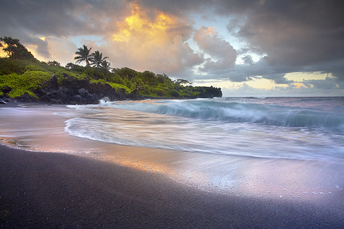


