Air Temperaturesranged between these warmest and coolest spots near sea level, and on the taller mountains…at 5 p.m. Monday evening:
Port Allen, Kauai– 86F Kapalua, Maui – 79 (light rain)
Haleakala Crater- 50 (near 10,000 feet on Maui)
Mauna Kea summit – 43 (near 14,000 feet on the Big Island)
Precipitation Totals – The following numbers represent the largest precipitation totals (inches) during the last 24 hours on each of the major islands, as of Monday afternoon: 0.39 Mount Waialaele, Kauai
1.20 South Fork Kaukonahua, Oahu
0.31 Molokai
0.02 Lanai
0.00 Kahoolawe 3.18 Puu Kukui, Maui
0.97 Kealakekua, Big Island
Weather Chart – Here’s the latest (automatically updated) weather mapshowing high pressure systems located to the northwest through northeast of Hawaii. Low pressure systems to the north of our trade wind producing high pressure systems, will cause lighter winds across our area into Wednesday.
Satellite and Radar Images: To view the cloud conditions we have here in Hawaii, please use the following satellite links, starting off with theInfrared Satellite Image of the islands to see all the clouds around the state during the day and night. This next image is one that gives close images of the islands only during the daytime hours, and is referred to as a Close-up visible image. This next image shows a larger view of the Pacific…giving perspective to the wider ranging cloud patterns in the Pacific Ocean. To help you keep track of where any showers may be around the islands, here’s the latest animatedradar image.
Hawaii’s Mountains – Here’s a link to the live webcam on the summit of near 14,000 footMauna Kea on the Big Island of Hawaii. The tallest peak on the island of Maui is theHaleakala Crater, which is near 10,000 feet in elevation. These two webcams are available during the daylight hours here in the islands…and when there’s a big moon rising just after sunset for an hour or two! Plus, during the nights and early mornings you will be able to see stars, and the sunrise too…depending upon weather conditions.
Aloha Paragraphs
Humpback cruising offshore from Lahaina Photo Credit: flickr.com
Breezy trade winds will remain active into Tuesday, then get softer for a few days thereafter…only to strengthen again later Friday into the weekend. The NWS forecast office in Honolulu continues its small craft wind advisories over those windiest areas around the state, stretching from the Kaiwi channel separating Oahu and Molokai…down across Maui to the Big Island in select coastal and channel waters Monday night. The trade winds will ease up in strength later Tuesday, blowing in the light to moderately strong realms. As we move into Friday and the weekend, they will surge back into the moderately strong category, with stronger gusts in those typically windier locales through the weekend. Moisture pockets being carried along in the trade wind flow, will keep showers falling at times along the windward sides…less showers along the leeward sides in general. Satellite imagery shows more of these passing showers on the horizon, so expect more of the same at times. The leeward sides will have fewer showers, although there may be a few around even there. We don’t expect anything too unusual in terms of precipitation, although the north fringe of a tropical system moving by to our south should increase showers later this week…most generously on Maui and the Big Island.
The Central Pacific Hurricane Center (CPHC) continues tracking tropical depression Kika, located far to the southwest of the islands Monday night. Here’s a looping satellite picture, showing this tropical cyclone moving away towards the west. Here’s a storm tracking map showing this tropical system in relation to the Hawaiian Islands. Looking to the of Hawaii, you will also see recently downgraded tropical storm Hernan in the eastern Pacific. Hernan is a gradually weakening tropical cyclone, which will dissipating in strength, as it moves over cooler water through the remainder of its life cycle. Despite all this tropical activity, neither of these storms will have any influence on our local weather here in the Hawaiian Islands. There is a chance that whatever leftover moisture, which may be involved with, what will then be former tropical cyclone Hernan…may bring some showers to the southern part of the state next week.
~~~ This satellite image shows the two main areas of interest around the Hawaiian Islands. The area to the southwest, to the lower left of the islands, is tropical depression Kika…no problem there as this system remains on course towards the west. The area of disturbed weather to the east-southeast, is a region of tropical moisture, around a vortex of low pressure. All the computer models show this tropical disturbance moving towards our islands, then turning westward…remaining to the south of Hawaii. There remains the good chance of showers arriving later this week, and that our local trade winds will accelerate as this tropical system moves by Friday into the weekend.
It’s early Monday evening here in Kihei, Maui, as I begin writing this last section of today’s narrative.
The new work started off in a pretty good way, with the trade winds still quite snappy, along with more of those common windward biased showers.
The strongest wind gust that I saw at 5pm was once again, which isn’t the slightest bit unusual…at Maalaea Bay on Maui, at 40 mph. The island of Lanai wasn’t too far behind, with the cup anemometer there twirling to the tune of 37 mph. Looking ahead, Tuesday will be a transition day, with our local trade winds finally starting to calm down. They will remain on the lighter side through Thursday, due to storms filing by in the middle latitudes to our north. Friday will be another transition day, as the trade winds surge again, and with quite a few showers riding in on the strengthening trades. The source of these showers will be an area of disturbed weather moving by to the south of Hawaii. I’ll be back very early Tuesday morning with your next new weather narrative from paradise, I hope you have a great Monday night until then! Aloha for now…Glenn.
Note:
I will be flying to Honolulu late Wednesday afternoon, to attend a Climate Conference on Oahu Thursday and Friday. Friends on Oahu, who live on the windward side in Kailua, have invited me to spend some time with them Friday night, Saturday and Sunday. I will fly back to Maui late Sunday afternoon. This means that I
will not be doing my tv weather show on Thursday, and then again not on Friday…which is a local state holiday. I will not be updating, or at least not regularly, this website during that time frame. The daily forecasts, in the upper left hand column on this and all other pages, will continue to have the latest weather forecasts however. Glenn
A new variety of premium grapes debuted in Japan on Monday, with a single bunch fetching as much as 100,000 yen, or $910. A Japanese hotel manager paid that amount, or about $26 per grape, for a 1 1/2 pound bunch of the Ruby Roman grapes to serve guests at an upscale hotel, officials said. "We believe the price was probably a record high," said local agricultural official Hirofumi Isu. "They’re delicious – sweet but fresh at the same time, very well balanced." The tomato-colored grapes made their debut at an auction in Japan‘s northwestern Ishikawa prefecture, where they have been under development since 1994 in a state-led project. The bunch that fetched the top price had about 35 grapes, each slightly smaller than a pingpong ball, Isu said.
The average price for the Ruby Roman grapes at Monday’s auction was about $245 a bunch. Isu said local farmers hope to sell 1,500 bunches, or 1 ton, of the grapes by mid-September. Fruit is generally expensive in Japan, and people often buy grapes, peaches and melons as luxury gifts. Japanese are often willing to pay top prices for high-end fruits, especially for the prestige of owning the very first ones of the year. Monday’s prices far exceeded those for the most popular premium variety, Muscat of Alexandria, which sell for as much as $90 a bunch at Tokyo‘s Ota fruit market, the country’s largest, according to Koichi Kato, an official at fruit wholesaler Tokyo Seika Co. "It could be a congratulatory price for its debut," Kato said of Monday’s auction in Ishikawa. "Tokyo‘s largest fruit market is very competitive."
Interesting2:
Already threatened by a thaw of ice around the North Pole, the polar bear’s title as the top Arctic predator may under challenge from a shark. Scientists researching how far sharks hunt seals in the Arctic were stunned in June to find part of the jaw of a young polar bear in the stomach of a Greenland shark, a species that favors polar waters. "We’ve never heard of this before. We don’t know how it got there," Kit Kovacs, of the Norwegian Polar Institute, told Reuters of the 10 cm (4 inch) bone found in a shark off the Norwegian Arctic archipelago of Svalbard. "We can’t say whether or not the shark took a swimming young bear" or ate a carcass, she said. "We don’t know how active these sharks are as predators." Most shark experts contacted said it was likely the bear was dead before the shark found it. Even a young, two- or three-year-old bear would be a ferocious opponent for a Greenland shark, which can grow to up to 7 meters (23 feet) and weigh more than a tonne. "It sounds like a scavenge," said Steve Campana, head of the Canadian shark research laboratory at the Department of Fisheries and Oceans.
He said he had not heard of a shark eating a bear before and it was a "million dollar question" for researchers as to whether Greenland sharks attack live bears. Bits of animals including caribou have been found in Greenland shark stomachs in the past — scavenged or attacked swimming. Campana said there was even a myth that the sharks could leap out of the water and seize caribou standing on ice. "There’s no possibility a Greenland shark could predate a live adult white bear unless it was injured or seriously ill," said Jeffrey Gallant, co-director of a Canadian-based Greenland shark education and research group. Sonja Fordham, deputy chair of the shark specialist group of the International Union for Conservation of Nature, said more research was needed into the Greenland shark’s habits. "Greenland sharks do seem quite sluggish … but they have been known to move very quickly when they are eating," she said.
Interesting3:
As the Arctic Ocean warms this century, shellfish, snails and other animals from the Pacific Ocean will resume an invasion of the northern Atlantic that was interrupted by cooling conditions three million years ago, predict Geerat Vermeij, professor of geology at the University of California, Davis, and Peter Roopnarine at the California Academy of Sciences. Climate models predict a nearly ice-free Arctic Ocean by 2050. That will restore conditions that last existed during the mid-Pliocene era around three to 3.5 million years ago. Several north Pacific species have relatives in the north Atlantic, and the fossil record shows a lot of invasion from the Pacific to the Atlantic at that time, Vermeij said. When cold conditions returned, the Arctic route was cut off, mostly by a lack of food. As the ice melts, productivity in the Arctic will rise and the northward march of the mollusks will resume where it left off three million years ago. Vermeij and Roopnarine reviewed literature on mollusks found in the Bering and Chuckchi seas between Alaska and eastern Siberia.
At least 77 molluscan lineages, about a third of the species of shallow-water shellfish in the Bering Sea, have the potential to spread to the Atlantic, they concluded. Three factors drove the one-way traffic across the North Pole during the Pliocene, Vermeij said. The Bering and Chukchi seas are very productive, with abundant food; there is a net northward flow of water from the Pacific through the Bering Strait; and strong competition in the Bering Sea means bigger, tougher animals. But the invaders will not wipe out native species, Vermeij said. The fossil record shows that invasions rarely lead to species extinction in marine environments, he said. Instead, the invasion will add new species and hybrids and increase competition in the North Atlantic. "The composition and dynamics of north Atlantic communities will change," Roopnarine said. "But whether that will help or harm local fisheries is an open question. Humans may have to adapt as well."
Interesting4:If wind energy converters are located anywhere near a residential area, they must never become too noisy even in high winds. Most such power units try to go easy on their neighbors’ ears, but even the most careful design cannot prevent noise from arising at times: One source is the motion of the rotor blades, another is the cogwheels that produce vibrations in the gearbox. These are relayed to the tower of the wind turbine, where they are emitted across a wide area — and what the residents hear is a humming noise. "People find these monotone sounds particularly unpleasant, rather like the whining of a mosquito," says André Illgen, a research associate at the Fraunhofer Institute for Machine Tools and Forming Technology IWU in Dresden.
If the wind energy converters hum too loudly, they are only permitted to operate under partial load: They rotate at a slower speed and generate less electricity. In some cases the operators have to install additional damping systems or even replace the gearbox — an expensive business. However, the effectiveness of the passive damping systems used until now is somewhat limited: They only absorb noise at a certain frequency. Since modern wind energy converters adapt their rotational speed to the wind velocity in order to generate as much electricity as possible, however, the frequency of the humming sound also varies. Despite noise attenuation measures, humming noises penetrate the surrounding area.
Air Temperaturesranged between these warmest and coolest spots near sea level, and on the taller mountains…at 4 p.m. Sunday afternoon:
Lihue, Kauai– 86F Hilo, Hawaii – 79
Haleakala Crater- 52 (near 10,000 feet on Maui)
Mauna Kea summit – 43 (near 14,000 feet on the Big Island)
Precipitation Totals – The following numbers represent the largest precipitation totals (inches) during the last 24 hours on each of the major islands, as of Sunday afternoon: 1.65 Mount Waialaele, Kauai
0.43 Poamoho 2, Oahu
0.01 Molokai
0.00 Lanai
0.02 Kahoolawe
0.93 West Wailuaiki, Maui
0.47 Pahoa, Big Island
Weather Chart – Here’s the latest (automatically updated) weather mapshowing high pressure systems located to the north through northeast of Hawaii. Our local winds be moderately strong, although stronger and gusty in the channels and those windiest places around the state.
Satellite and Radar Images: To view the cloud conditions we have here in Hawaii, please use the following satellite links, starting off with theInfrared Satellite Image of the islands to see all the clouds around the state during the day and night. This next image is one that gives close images of the islands only during the daytime hours, and is referred to as a Close-up visible image. This next image shows a larger view of the Pacific…giving perspective to the wider ranging cloud patterns in the Pacific Ocean. To help you keep track of where any showers may be around the islands, here’s the latest animatedradar image.
Hawaii’s Mountains – Here’s a link to the live webcam on the summit of near 14,000 footMauna Kea on the Big Island of Hawaii. The tallest peak on the island of Maui is theHaleakala Crater, which is near 10,000 feet in elevation. These two webcams are available during the daylight hours here in the islands…and when there’s a big moon rising just after sunset for an hour or two! Plus, during the nights and early mornings you will be able to see stars, and the sunrise too…depending upon weather conditions.
Aloha Paragraphs
Hilo Bay, with rainbow and showers…not all that unusual Photo Credit: flickr.com
Our local trade winds will remain on the breezy side…then relax a little as we move into the new week ahead. The NWS forecast office in Honolulu continues its small craft wind advisories over those windiest areas around the state, stretching from the Kaiwi channel separating Oahu and Molokai…down across Maui to the Big Island in select coastal and channel waters. The trade winds will ease up in strength by Tuesday, but remain active well into the future, keeping moderately strong trade winds blowing across our tropical latitudes of the north central Pacific through the work week…picking up again next weekend.There don’t appear to be any organized rain makers taking aim on our Hawaiian Islands for the time being. The rainfall associated with compact tropical depression Kika, is too far south to bring moisture up into our latitudes. This leaves us in what we could consider a fairly normal trade wind weather pattern, with just the usual generally light passing showers, favoring the night and early morning hours. Most leeward beaches will remain dry, although there may be an occasional shower here and there. There’s a chance that later in the new work week, that we may find an increase in showers, as moisture arrives from the deeper tropics to the southeast.
The Central Pacific Hurricane Center (CPHC) continues tracking tropical depression Kika, our first cyclone of the 2008 hurricane season…located to the southwest of the islands Sunday evening. Here’s a looping satellite picture of this tropical cyclone. Here’s a storm tracking map to show this tropical system in relation to the Hawaiian Islands – please note that we have a hurricane in the eastern Pacific, named Hernan. Hernan is a gradually weakening hurricane, which has peaked out in strength, and is destined for the tropical cyclone graveyard, as it moves over cooler water over the next 4-5 days. Despite all this tropical activity, neither of these storms will have any influence on our local weather here in the Hawaiian Islands. There is a chance that whatever leftover moisture that may be involved with what will then be former hurricane Hernan…may bring some showers to the southern part of the state eventually.
~~~ This satellite image shows the three main areas of interest around the Hawaiian Islands. The area north-northeast of Hawaii is rapidly thinning high cirrus clouds, too far away to dim our daytime sunshine. The area to the southwest, below the islands, is tropical depression Kika…no problem there as this system remains on course towards the west. The large area to the east-southeast, is a region of tropical moisture, which may move northwest over our area later in the new week ahead? If it were to move into our islands, or near by, there’s a chance it could deposit rainfall, perhaps even heavy preciptiation, which would be a positive step in pushing back the drought conditions that exist in many parts of the Hawaiian Islands at the moment. We’ll have to wait and see if this area develops into a tropical cyclone, in which case it could bring rains to the Big Island and Maui around Thursday or Friday…that’s still a question however.
It’s early Sunday evening here in Kula, Maui, as I begin writing this last section of today’s narrative. Sunday was a hot day, even in the upcountry areas, with elevations between 2,000 and 4,000 feet. All that heat, caused clouds to gather along the slopes of the mountains…which dropped late afternoon showers locally, which is fairly common here in the tropics. The winds remained rather blustery down hear the coasts, with the ocean chalked-up with white caps, and the coconut palm trees swaying to and fro. The strongest gusts late Sunday afternoon occurred here on Maui, where Maalaea Bay had winds topping out at 38 mph, while the Kahului airport saw winds reaching 40 mph! Here in Kula, at the 3,100 foot elevation, my wind chimes are sounding off, although faintly under the influence of only light breezes. Monday will continue the long number of days with at least moderately strong trade winds blowing, with the trade winds tempering some starting Tuesday, as a low pressure system in the Gulf of Alaska erodes the high pressure cell and ridges to our north then. I’ll be back very early Monday morning with your next new weather narrative from paradise. I hope you have a great Sunday night wherever you happen to be reading from! Aloha for now…Glenn.
Air Temperaturesranged between these warmest and coolest spots near sea level, and on the taller mountains…at 5 p.m. Saturday evening:
Honolulu, Oahu– 85F Molokai airport – 79
Haleakala Crater- 50 (near 10,000 feet on Maui)
Mauna Kea summit – 39 (near 14,000 feet on the Big Island)
Precipitation Totals – The following numbers represent the largest precipitation totals (inches) during the last 24 hours on each of the major islands, as of Saturday afternoon: 1.27 Mount Waialaele, Kauai
0.31 South Fork Kaukkonahua, Oahu
0.03 Molokai
0.09 Lanai
0.02 Kahoolawe
0.57 Puu Kukui, Maui
0.20 Glenwood, Big Island
Weather Chart – Here’s the latest (automatically updated) weather mapshowing a 1026 millibar high pressure system located to the north of Hawaii. Our local winds be moderately strong, although stronger and gusty in the channels and those windiest places around the state…lighter Monday.
Satellite and Radar Images: To view the cloud conditions we have here in Hawaii, please use the following satellite links, starting off with theInfrared Satellite Image of the islands to see all the clouds around the state during the day and night. This next image is one that gives close images of the islands only during the daytime hours, and is referred to as a Close-up visible image. This next image shows a larger view of the Pacific…giving perspective to the wider ranging cloud patterns in the Pacific Ocean. To help you keep track of where any showers may be around the islands, here’s the latest animatedradar image.
Hawaii’s Mountains – Here’s a link to the live webcam on the summit of near 14,000 footMauna Kea on the Big Island of Hawaii. The tallest peak on the island of Maui is theHaleakala Crater, which is near 10,000 feet in elevation. These two webcams are available during the daylight hours here in the islands…and when there’s a big moon rising just after sunset for an hour or two! Plus, during the nights and early mornings you will be able to see stars, and the sunrise too…depending upon weather conditions.
Aloha Paragraphs
Rocky Point, on the island of Oahu Photo Credit: flickr.com
Our local trade winds will remain on the breezy side…then relax a little as we move into the new week ahead. The NWS forecast office in Honolulu continues its small craft wind advisories over those windiest areas around the state, stretching from the Kaiwi channel separating Oahu and Molokai…down across Maui to the Big Island in select coastal and channel waters. The trade winds will relax in strength after the weekend, but remain active well into the future, keeping moderately strong trade winds blowing across our tropical latitudes of the north central Pacific.There don’t appear to be any organized rain makers taking aim on our Hawaiian Islands for the time being. The rainfall associated with compact tropical depression Kika, is too far south to bring moisture up into our latitudes. This leaves us in what we could consider a fairly normal trade wind weather pattern, with just the usual generally light passing showers, favoring the night and early morning hours. Most leeward beaches will remain dry, although there may be an occasional shower here and there. There’s a chance that later next week may find an increase in showers, as moisture arrives from the deeper tropics.
The Central Pacific Hurricane Center (CPHC) continues tracking recently upgraded tropical storm Kika, our first cyclone of the 2008 hurricane season…located to the south of the islands Saturday night. Here’s a looping satellite picture of this tropical cyclone. Here’s a storm tracking map to show this tropical system in relation to the Hawaiian Islands – please note that we have a hurricane in the eastern Pacific, named Hernan. Hernan is a strong hurricane with winds near 120 mph, which will be peaking out in strength soon, before it moves over cooler water and down cycles in strength thereafter. Despite all this tropical activity, neither of these storms will have any influence on our local weather here in the Hawaiian Islands.
~~~ This satellite image shows the three main areas of interest around the Hawaiian Islands. The area north of Hawaii is high cirrus clouds, no rain there, and too far away to dim our moon or sunshine at the moment. The area to the south, below the islands, is tropical storm Kika moving to the west more or less. The large area to the southeast, to the lower right of the islands, is an area of tropical moisture, which may or may not move northwest over our area later in the new week ahead? If it were to move into our neck of the woods, there’s a chance it could deposit rainfall, perhaps even heavy preciptiation, which would be a positive step in pushing back the drought conditions that exist in many parts of the Hawaiian Islands at the moment. The GFS model (at the time of this writing) shows this area of tropical clouds moving more or less towards us during the next week, with the trade winds carrying it by to our south thereafter. I wonder if the northern fringe of that cloud shield might bring rains to the Big Island and Maui around next Thursday or Friday?
It’s early Saturday evening here in Kula, Maui, as I begin writing this last section of today’s narrative. Saturday was a great day here in the islands, albeit it a bit windier than usual in some places. Skies remained quite clear and sunny generally, with just the few showers falling as expected, along the windward sides of the islands. I see little change in store through the rest of this weekend. I had to go over to Haiku for a haircut this morning, which put me within close proximity of Baldwin Beach. I hit the beach, only to find the sand blowing around, and the ocean full of white caps. I took a nice walk anyway, and found the ocean to be warm and friendly, even though the waves were somewhat larger than what I would expect on a summer day. All the trade winds have kicked up a wind swell along our east facing beaches, which send some wrapping waves over to the north shores. When I drove by Hookipa Beach Park, there were members of the surfing and windsurfing communities taking full advantage of the waves that were breaking there. I’m home in Kula now, and ready to watch what looks like it will be a nice sunset from my weather deck. I’ll be back Sunday morning with your next new weather narrative, I hope you have a great Saturday night wherever you happen to be spending it! Aloha for now…Glenn.
Air Temperaturesranged between these warmest and coolest spots near sea level, and on the taller mountains…at 5 p.m. Friday evening:
Barking Sands, Kauai– 84F Hilo, Hawaii – 77 (Light rain)
Haleakala Crater- 59 (near 10,000 feet on Maui)
Mauna Kea summit – 43 (near 14,000 feet on the Big Island)
Precipitation Totals – The following numbers represent the largest precipitation totals (inches) during the last 24 hours on each of the major islands, as of Friday afternoon: 1.07 Mount Waialaele, Kauai
0.27 Manoa Valley, Oahu
0.06 Molokai
0.00 Lanai
0.01 Kahoolawe
0.53 West Wailuaiki, Maui
0.82 Glenwood, Big Island
Weather Chart – Here’s the latest (automatically updated) weather mapshowing a 1029 millibar high pressure system located to the north of Hawaii. Our local winds be moderately strong…although stronger and gusty in the channels and those windiest places around the state through Sunday.
Satellite and Radar Images: To view the cloud conditions we have here in Hawaii, please use the following satellite links, starting off with theInfrared Satellite Image of the islands to see all the clouds around the state during the day and night. This next image is one that gives close images of the islands only during the daytime hours, and is referred to as a Close-up visible image. This next image shows a larger view of the Pacific…giving perspective to the wider ranging cloud patterns in the Pacific Ocean. To help you keep track of where any showers may be around the islands, here’s the latest animatedradar image.
Hawaii’s Mountains – Here’s a link to the live webcam on the summit of near 14,000 footMauna Kea on the Big Island of Hawaii. The tallest peak on the island of Maui is theHaleakala Crater, which is near 10,000 feet in elevation. These two webcams are available during the daylight hours here in the islands…and when there’s a big moon rising just after sunset for an hour or two! Plus, during the nights and early mornings you will be able to see stars, and the sunrise too…depending upon weather conditions.
Aloha Paragraphs
Hana Bay, on the island of Maui Photo Credit: flickr.com
Brisk trade winds will bring their cooling and refreshing relief from the August heat through Sunday…then relax a little as we move into the new week ahead. The NWS forecast office in Honolulu continues its small craft wind advisories over those windiest areas around the state, stretching from the Kaiwi channel separating Oahu and Molokai…down across Maui to the Big Island in select coastal and channel waters. The trade winds will carry periodic showers onto the windward sides, while most leeward areas will remain dry and quite sunny during the days. There don’t appear to be any organized rain makers taking aim on our Hawaiian Islands for the time being. The rainfall associated with compact tropical depression Kika, is too far south to bring moisture up into our latitudes. This leaves us in what we could consider a fairly normal trade wind weather pattern, with just the usual generally light passing showers, favoring the night and early morning hours. There’s a chance that later next week may find better odds for an increase in showers, as tropical moisture arrives.
The Central Pacific Hurricane Center (CPHC) continues tracking recently down graded tropical depression Kika, our first cyclone of the 2008 hurricane season…located to the south of the island Friday evening. Here’s a looping satellite picture of this tropical cyclone. Here’s a storm tracking map to show this tropical system in relation to the Hawaiian Islands – please note that we have a hurricane in the eastern Pacific, named Hernan. Despite all this tropical activity, none of this will have any influence on our local weather here in the Hawaiian Islands. Kika is too far away to have any discernable influence on our local weather. The hurricane models have Kika increasing in strength now, which will likely push it back into the tropical storm category…while is continues its more or less westward movement.It’s early Friday evening here in Kihei, Maui, as I begin writing this last section of today’s narrative. Friday was yet another fairly windy day, like all the days this week have been. The strongest gust that I saw occurred on Kahoolawe during the afternoon hours, reaching an impressive 42 mph. At 530pm Maalaea Bay here on Maui, was still reading 38 mph, which is certainly enough to keep the waters of that windy bay roughed-up with choppy water full of white caps. Meanwhile, Kika is still churning by us to the south, and ready to increase in strength, back up into the tropical storm level. This storm continues to be not a problem here in the Hawaiian Islands. Here’s the latest satellite image of this small compact storm directly south of our islands Friday night. Looking at that satellite picture, we see just scattered clouds being carried in our direction on the trade winds, although as you can see, nothing organized in nature. I would typically go see a new film after work, but the truth is that I don’t see anything that really pulls me in, so I’m just going to go home and have a relaxed evening reading or whatever. I hope you have a great Friday night, and will join me here again early Saturday morning, when I’ll have your next new weather narrative from paradise available then. Aloha for now…Glenn.
Crystal Blue Persuasion…Tommy James and the Shondells – as a Friday evening treat from the past.
Tokyo Electric Power Co (TEPCO) plans to set up as many as 200 recharging stations for electric cars around the Japanese capital next year, the Nikkei business daily reported on Friday.But a TEPCO spokesman denied the report and said: "While it is not wrong that TEPCO has completed demonstration tests for devices that charge batteries, we do not at this time have plans to take the initiative in setting up charging locations within the city." EPCO, Japan’s largest utility, has developed a device that powers an electric car to run 40 km (25 miles) after a five-minute charge and 60 km (37 miles) after a 10-minute charge, the spokesman said.
Car makers such as Nissan Motor and Mitsubishi Motors are preparing to roll out electric vehicles in coming years, amid soaring gasoline fuel prices and concerns about global warming. Car dealers selling Mitsubishi Motors and Subaru cars made by Fuji Heavy Industries have agreed to have TEPCO’s recharging stations at their shops, while supermarket retailer Aeon plans to host them at some outlets, the paper said. It said TEPCO would also include carparks, convenience stores, banks and post offices in the charging network it plans to set up in the financial year to March 2010, with the aim of expanding the number of stations to around 1,000 in three years or so. Interesting2:
When you buy food with a "USDA organic" label, do you know what you’re getting? Now is a good time to ask such a question, as the USDA just announced Monday it was putting 15 out of 30 federally accredited organic certifiers they audited on probation, allowing them 12 months to make corrections or lose their accreditation. At the heart of the audit for several certifiers were imported foods and ingredients from other countries, including China. Chinese imports have had a bad year in the news, making headlines for contaminated pet food, toxic toys, and recently, certified organic ginger contaminated with levels of a pesticide called aldicarb that can cause nausea, headaches and blurred vision even at low levels. The ginger, sold under the 365 label at Whole Foods Market, contained a level of aldicarb not even permissible for conventional ginger, let alone organics.
Whole Foods immediately pulled the product from its shelves. Ronnie Cummins, the national director of the Organic Consumers Association, emphasizes that most organic farmers "play by the rules." They believe in organic principles and thereby comply with organic standards. Unfortunately, Congress’ pitifully inadequate funding for enforcement, including for organic imports from countries like China, "guarantees it’ll be easy for unscrupulous players to cheat, and that’s obviously what’s going on here." Farms that produce USDA-certified organic food are not personally inspected by anyone from the USDA National Organic Program (NOP). As a small and underfunded agency within the USDA (it has fewer than a dozen employees), NOP relies on what it calls Accredited Certifying Agencies — ACAs — to do the legwork. The ACAs take responsibility for ensuring that any farm or processor bearing the organic label meets the strict requirements for certification.
Interesting3:
The GangesRiver in India, is proof that even the holiest of nature's creations can fall victim to the destructive powers of pollution. Thousands of Hindu followers have their bodies committed to the Ganges each year in belief that the river's waters will carry their souls to eternal salvation. With nearly 89 million liters of raw sewage flowing into the Ganges each day, the health of the waterway is now worse than ever before. Existing facilities can often treat only 13 percent of this pollution. Those who drink from the river risk contracting waterborne diseases such as typhoid, polio, and jaundice. In hopes of improving the river's fate, a coalition of Hindu spiritual leaders, environmental scientists, and water advocates is threatening the Indian government with large-scale protests if sanitation controls are not soon improved. They are calling for the government to increase pollution penalties and declare the GangesRiver a national heritage site, which they say would ensure better environmental controls.
"The river is choking with filth. Effluents from all the cities and industries drain into the river unchecked, and it affects the lives of nearly 500 million people," said Baba Ramdev, a popular yoga teacher, the Indo-Asian News Service reported. "If the government refuses to concede our demands, then we will launch a mass movement from September 18." The increased frustration over sanitation is not unique to India. Worldwide, a growing number of activists are demanding that their governments move beyond rhetoric on water policy this year, the United Nations-designated International Year of Sanitation. The U.N. General Assembly created the International Year of Sanitation to raise awareness for the U.N. Millennium Development Goal that by 2015 the number of people who live without access to decent sanitation will be cut in half. But progress has so far fallen below expectations.
Interesting4:
Federal health experts declared a small victory against a fatal and untreatable virus on Friday, saying canine rabies has disappeared from the United States. While dogs may still become infected from raccoons, skunks or bats, they will not catch dog-specific rabies from another dog, the Atlanta-based U.S. Centers for Disease Control and Prevention said. "We don't want to misconstrue that rabies has been eliminated -- dog rabies virus has been," CDC rabies expert Dr. Charles Rupprecht told Reuters in a telephone interview. Rabies evolves to match the animals it infects, and the strain most specific to dogs has not been seen anywhere in the United States since 2004, Rupprecht said. While the incubation period for rabies is as long as six years in humans, it is only six months in a dog.
"Even though we still live in a sea of rabies and even though we have rabies viruses circulating among raccoons and foxes and bats, the dog rabies virus, which is the most responsible for dog-to-dog transmission and which is still the greatest burden to humans ... it is that virus that has been eliminated." Rabies kills 55,000 people a year globally, according to the World Health Organization. It is easily prevented with a vaccine, but many people do not realize they have been infected and once symptoms begin to show, it is almost impossible to treat.
Air Temperaturesranged between these warmest and coolest spots near sea level, and on the taller mountains…at 4 p.m. Thursday afternoon:
Honolulu, Oahu– 86F Hilo, Hawaii – 76
Haleakala Crater- 55 (near 10,000 feet on Maui)
Mauna Kea summit – 45 (near 14,000 feet on the Big Island)
Precipitation Totals – The following numbers represent the largest precipitation totals (inches) during the last 24 hours on each of the major islands, as of Thursday afternoon: 2.30 Mount Waialaele, Kauai
0.64 Oahu Forest NWR, Oahu
0.10 Molokai
0.00 Lanai
0.00 Kahoolawe
1.56 West Wailuaiki, Maui
0.54 Glenwood, Big Island
Weather Chart – Here’s the latest (automatically updated) weather mapshowing a 1030 millibar high pressure system located to the north-northeast of Hawaii. Our local winds be moderately strong…although stronger and gusty in the channels and those windiest places around the state through Saturday.
Satellite and Radar Images: To view the cloud conditions we have here in Hawaii, please use the following satellite links, starting off with theInfrared Satellite Image of the islands to see all the clouds around the state during the day and night. This next image is one that gives close images of the islands only during the daytime hours, and is referred to as a Close-up visible image. This next image shows a larger view of the Pacific…giving perspective to the wider ranging cloud patterns in the Pacific Ocean. To help you keep track of where any showers may be around the islands, here’s the latest animatedradar image.
Hawaii’s Mountains – Here’s a link to the live webcam on the summit of near 14,000 footMauna Kea on the Big Island of Hawaii. The tallest peak on the island of Maui is theHaleakala Crater, which is near 10,000 feet in elevation. These two webcams are available during the daylight hours here in the islands…and when there’s a big moon rising just after sunset for an hour or two! Plus, during the nights and early mornings you will be able to see stars, and the sunrise too…depending upon weather conditions.
Aloha Paragraphs
The steep cliffs on the north shore of Molokai Photo Credit: flickr.com
Our local trade winds will remain somewhat stronger than normal for the time being…then relax in strength some later this weekend into next week. The NWS forecast office in Honolulu has a small craft wind advisory active in those windiest areas around the state, stretching from the Kaiwi channel separating Oahu and Molokai…down across Maui to the Big Island in select coastal and channel waters. Our local trade winds will reach their peak in strength today into Saturday, relaxing some during the second half of the weekend. The computer forecast models show no end to the breezy trade winds, continuing right on into next week. There will be showers falling along the windward sides, mostly at night, and locally along the leeward slopes…mostly commonly in Kona. As the trade winds remain gusty through Saturday, there will continue to be those occasional passing showers along the windward sides of the islands at times. The weather is expected to turn somewhat drier again as we move into the upcoming weekend…as the trade winds slip back a little in strength then. The leeward sides should be quite dry, although there will be a few afternoon showers falling locally.
The central Pacific has its first tropical storm of the 2008 hurricane season, in the form of Kika…located to the south-southeast of the Big Island. Here’s a looping satellite picture of that tropical cyclone, down to the more or less south of the Big Island. Here’s a storm tracking map to show this storm in relation to the Hawaiian Islands – please notice that we have a strengthening tropical storm in the eastern Pacific as well, called Hernan. Despite all this tropical activity, none of this will have any influence on our local weather here in the Hawaiian Islands. We may see some increase in showers later next week, as whatever is left of, what will then be retired tropical cyclone Hernan…gets carried our way on the trade winds.It’s early Thursday evening here in Kihei, Maui, as I begin writing this last section of today’s narrative. Thursday was a generally sunny day, at least in most areas. The trade winds got frisky as expected this afternoon, with locally blustery conditions here and there. While I was near the beach in Kihei during lunch, there was sand blowing off the beaches, in drifts, getting carried across South Kihei Road…just like it did on Wednesday. The ocean just offshore from Kihei was filled with small white caps, chalking-up the surface significantly. Our local winds remain somewhat stronger than normal going into Friday, with not all that many showers…although looking at this satellite image, it appears that the windward sides will find perhaps some increase in moisture during the overnight hours. Meanwhile, tropical storm Kika will remain well south of the Hawaiian Islands, as it continues passing to the south of Hawaii. There won’t be any influence of this first tropical storm on us, other than reminding ourselves that storms can come relatively close during our hurricane season…how close is always the big question this time of year! There will be more storms forming in the eastern Pacific, moving over into our central Pacific at times during the next month or more. I’ll be back very early Friday morning with your next new weather narrative from paradise. I hope you have a great Thursday night until then! Aloha for now…Glenn.
Interesting:The phenomenon that causes a diamond to sparkle could be used to find large bodies of water on rocky, Earth-like planets, says Darren M. Williams, lead author of a paper in Icarus that describes the process. The trick, he says, is to look for planets when they are in crescent phase, ideally in orbits that lie at an edge-on angle to Earth. In that position, the glare bouncing off the water would make the planet seem unusually bright. "Crescent phase is where the starlight would be glancing off the edge of the planet toward our telescopes," says Williams, an associate professor of physics and astronomy at Penn State Erie. "That would be when the light is coming at the surface at a very steep angle, and the spectacular reflection would be the strongest and most intense."
Williams ran simulations of idealized, cloud-free planets with three types of surfaces: unfrozen land, snow and ice, and water. His goal was to see to what extent the presence of water would contribute to the light coming from a planet in another solar system. He found that for slightly tilted systems the reflection from water would be the most powerful signal, particularly if the planet were observed in crescent phase. When a star appears directly over a body of water, almost all the light is absorbed. But from a glancing angle, most of the light is reflected. The shape of the light curve would help distinguish Earth-like planets with water from those without.
Interesting2:
Americans are drinking less alcohol, with middle-aged people consuming about one-third less than 50 years ago, researchers report. Overall, Americans are drinking less beer, but more wine, while consumption of hard liquor has remained fairly constant. Also, more people say they don’t drink, and those born later in the 20th century are more moderate drinkers than their parents. "It looks like moderate drinking has been increasing, heavy drinking is down a little bit, and total alcohol consumption is down a little bit," said lead researcher Dr. R. Curtis Ellison, a professor of medicine and public health at Boston University School of Medicine. "It is encouraging news that more people are drinking moderately, and the average intake is coming down rather than shooting up," he said. For the study, Ellison’s team collected data on 8,000 people who took part in the Framingham Heart Study.
People in the initial arm of the study were born before 1900 up until 1959. Those from the initial enrollment group as well as their children were interviewed every four years from 1948 to 2003 about their alcohol consumption. Ellison explained that the Framingham study consists primarily of white, middle-class individuals from the Massachusetts town of the same name. "It generally tends to reflect trends within the country among middle-class, white Americans," he said. The researchers found that, overall, people are drinking less. "People drank about a third more back in the ’50s and ’60s than they did in the ’70s up to 2004," Ellison said. There’s been a gradual decrease in the average amount of alcohol people drink. For instance, alcohol consumption among men has gone from about two-and-a-half drinks a day to one-and-a-half drinks a day, Ellison said. "At the same time, there’s been a decrease in beer and an increase in wine consumption among people. But the average intake has decreased," he said.
Interesting3:
Whenthe Opening Ceremonies launch the XXIX Olympiad in Beijing on Friday, city officials will no doubt hope their efforts pay off to reduce the city's usual pall of smog and bring blue skies to the games. But their policies may matter little in the face of the region's weather — the main influence on Beijing's pollution levels, according to one scientist. Air pollution in Beijing, and much of the rest of China, has skyrocketed in recent decades, due in large part to a booming economy and rapid industrialization, as well as the nation's huge population, who desire the same amenities as westerners. About 1,000 cars are added to the roads of Beijing alone each year, while China as a whole is commissioning one new coal-burning power plant each week and construction is rampant.
After winning the bid in 2001 for this year's Summer Olympics, Beijing pledged to bring down pollution levels in time for the Opening Ceremonies, which will be held on Friday. Since then, the country has been investing in cleaner technologies and improving public transportation and has succeeded in decreasing the levels of some pollutants, such as sulfur dioxide, generated by burning coal. But the scale of the problem has forced officials to also institute more short-term policies to bring down levels of particulate matter (PM), tiny particles suspended in the air and created by factories, coal burning for heat and combustion in vehicles. Beginning on July 20, Beijing officials instituted a ban that took 50 percent of Beijing's cars off the roads and began shutting down hundreds of factories in and around the city.
Air Temperaturesranged between these warmest and coolest spots near sea level, and on the taller mountains…at 4 p.m. Wednesday afternoon:
Port Allen, Kauai– 88F Hilo, Hawaii – 73 (Light rain)
Haleakala Crater- 48 (near 10,000 feet on Maui)
Mauna Kea summit – 41 (near 14,000 feet on the Big Island)
Precipitation Totals – The following numbers represent the largest precipitation totals (inches) during the last 24 hours on each of the major islands, as of Wednesday afternoon: 0.16 Mount Waialaele, Kauai
0.07 Hakipuu Mauka, Oahu
0.00 Molokai
0.00 Lanai
0.00 Kahoolawe
0.27 Oheo Gulch, Maui 0.58 Pahoa, Big Island
Weather Chart – Here’s the latest (automatically updated) weather mapshowing a 1030 millibar high pressure system located to the north-northeast of Hawaii. Our local winds be moderately strong…although stronger and gusty in the channels and those windiest places around the state.
Satellite and Radar Images: To view the cloud conditions we have here in Hawaii, please use the following satellite links, starting off with theInfrared Satellite Image of the islands to see all the clouds around the state during the day and night. This next image is one that gives close images of the islands only during the daytime hours, and is referred to as a Close-up visible image. This next image shows a larger view of the Pacific…giving perspective to the wider ranging cloud patterns in the Pacific Ocean. To help you keep track of where any showers may be around the islands, here’s the latest animatedradar image.
Hawaii’s Mountains – Here’s a link to the live webcam on the summit of near 14,000 footMauna Kea on the Big Island of Hawaii. The tallest peak on the island of Maui is theHaleakala Crater, which is near 10,000 feet in elevation. These two webcams are available during the daylight hours here in the islands…and when there’s a big moon rising just after sunset for an hour or two! Plus, during the nights and early mornings you will be able to see stars, and the sunrise too…depending upon weather conditions.
Aloha Paragraphs
Hilo, Hawaii…often quite cloudy and showery Photo Credit: flickr.com
Our local trade winds will remain stronger than normal through Friday…and then relax in strength a little this weekend into next week. The NWS forecast office in Honolulu has a small craft wind advisory for those windiest areas around the state, stretching from the Kaiwi channel separating Oahu and Molokai…down across Maui to the Big Island. Our local trade winds will reach their peak in strength Thursday and Friday, easing off a touch during the weekend. The computer forecast models show no end to the breezy trade winds, continuing right on into next week.
There will be showers falling along the windward sides, mostly at night, and along the leeward slopes…mostly during the afternoons. As the trade winds remain gusty Thursday and Friday, all that wind will force at least some moisture up the sides of the volcanic slopes, on the windward sides…which will cause a minor increase in showers. The weather is expected to turn somewhat drier again as we move into the upcoming weekend…as the trade winds slip back some in strength just a little. The leeward sides should be quite dry, although there could be a few afternoon showers falling locally.
An area of disturbed weather, to the southeast of the Big Island, has spun up into the central Pacific’s first tropical depression of the 2008 hurricane season. Here’s a looping satellite picture of that tropical depression, called 01C, down to the lower right of the Big Island. Here’s a storm tracking map to show this depression in relation to the Hawaiian Islands – please notice that we have a new tropical storm in the eastern Pacific also, called Hernan. There are no signs of 01C moving northward towards the Hawaiian Islands. By the way, while we’re looking at that looping satellite image, we can see lots of high cirrus clouds coming up from the deeper tropics to our southwest…which has dimmed and filtered our Hawaiian sunshine at times locally. This cirrus cloudiness should be moving away Thursday, for more sunshine.
~~~ It’s early Wednesday evening here in Kihei, Maui, as I begin writing this last section of today’s narrative. High clouds blocked our sunshine quite a bit Wednesday, too much so I’m sure for many folks! There were more than expected lower level clouds too, quite a a few of which dropped showers. Meanwhile, the trade winds continued to be on the strong and gusty side, at least locally…although even in this department, the winds were somewhat lighter than forecast too. All in all, the forecast today bombed to some degree! At 5pm the strongest wind gust that I saw was the 40 mph reading at Maalaea Bay here on Maui. While all this was happening, we had that a tropical disturbance to our southeast upgraded to a tropical depression named 01C. It is expected to take on the Hawaiian name of Kika once it, or if it strengthens into a tropical storm…which the forecasts have it doing so eventually. It poses no threat to the Hawaiian Islands, as you can see from the tracking map that I added a couple of paragraphs up this page. That doesn’t mean we don’t have to keep a sharp eyeball on it, as these storms can be tricky, and do things we don’t expect sometimes! I’ll be back very early Thursday morning with your next new weather narrative from paradise, I hope you have a great Wednesday night until then! Aloha for now…Glenn.
Interesting:
If you have a car, stop whatever you’re doing and go check the air pressure of your vehicle’s tires. Apart from keeping your car in park, pumping up your tires to their proper "PSI" – pounds per square inch – is the fastest, cheapest way to reduce the amount of gasoline you use. Tires have a tendency to lose pressure over time or when the weather changes substantially; a car driving on underinflated tires needs more gas to move. You can gain 3.3% in fuel efficiency by inflating your tires. And with gasoline costing over $4/per gallon, every 3.3% gain means money in your pocket. That gain also affords an immediate way to increase our supply of oil. As Barack Obama has noted in his vision for an energy independent America, if we all pumped up our tires to their proper PSI, the U.S. could easily gain from conservation (i.e., using less fuel) three times as much oil as we could reap from far more costly and environmentally dangerous off-shore oil drilling.
And that oil is available TODAY, not ten or twenty years hence – the time it takes to develop oil fields and convert petroleum into gasoline. "Efforts to improve conservation and efficiency happen to be the best approaches to dealing with the energy crisis — the cheapest, cleanest, quickest and easiest ways to ease our addiction to oil, reduce our pain at the pump and address global warming. It’s a pretty simple concept: if our use of fossil fuels is increasing our reliance on Middle Eastern dictators while destroying the planet, maybe we ought to use less," writes Michael Grunwald in Time. Tire gauges are cheap.
Interesting2:
Scientists have created the world’s thinnest balloon, made of a single layer of carbon just one atom thick. The fabric that the balloon is made of is leakproof to even the tiniest airborne molecules. It could find use in "aquariums" smaller than a red blood cell, through which scientists could peer at molecules, researchers suggested. The balloon is made of graphite, as found in pencils, which is made of atom-thin sheets of carbon stacked on top of each other known. The sheets are known as graphene. Graphene is highly electrically conductive, and scientists are feverishly researching whether it could find use in advanced circuitry and other devices. "We were studying little graphene trampolines, and by complete accident, we made a graphene sheet over a hole. Then we started studying it, and saw that it was trapping gas inside," said researcher Paul McEuen, a physicist at CornellUniversity in Ithaca, N.Y.
By experimenting further with bubbles made of graphene, McEuen and his colleagues found the membranes were impermeable to even the smallest gas molecules, including helium. "It’s amazing that something only an atom thick can be an impenetrable barrier. You can have gas on one side and vacuum or liquid on the other, and with a wall only one atom thick, nothing would go through it," McEuen told LiveScience. In terms of applications, McEuen suggested one possibility which he called miniature aquariums for molecules. "You could have instruments on one side of the membrane, in vacuum or air, and on the other side you would have DNA or proteins suspended in liquid," he explained. "And then you could get right up close to image the molecules, within a few angstroms," or widths of an atom. Other potential applications include hyper-fine sensors and ultra-pure filters.
Interesting3: The answer to “Got milk?” just got a little older: A new study indicates that people have been milking cattle and other domesticated animals as well as processing and storing milk products for 2,000 years longer than originally thought. A group of scientists studied thousands of pottery shards from sites all over the Near East and the Balkans and tested them for residues of milk fats. They found that milk was already being used and processed by societies there by the seventh millennium B.C. Previously, the earliest evidence of milk use came from the fifth millennium, though cattle, sheep and goats had already been domesticated by the eighth millennium. The traces of milk fats can survive on the pottery, even after being buried for thousands of years, because the fats are hydrophobic, so they don’t dissolve in water, and they are produced in large amounts, said study leader Richard Evershed of the University of Bristol in England.
Ceramic vessels are very porous, so if you store or cook animal products in them, "the pottery vessels pick up that organic matter like crazy," Evershed told LiveScience. The residues don’t indicate the presence of milk itself, as those would decay away very quickly, but instead suggest more processed dairy substances, such as butter, yogurt, ghee (or clarified butter), and possibly cheese, though cheese is largely altered by microbes and so may not leave a recognizable dairy signature, Evershed said. Evershed and his colleagues were surprised that they found the most residues in sites in Anatolia (most of modern Turkey), which lies outside the traditional Fertile Crescent region where agriculture was first developed.
Air Temperaturesranged between these warmest and coolest spots near sea level, and on the taller mountains…at 4 p.m. Tuesday afternoon:
Kapalua, Maui– 86F Princeville, Kaui – 81
Haleakala Crater- mm (near 10,000 feet on Maui)
Mauna Kea summit – 34 (near 14,000 feet on the Big Island)
Precipitation Totals – The following numbers represent the largest precipitation totals (inches) during the last 24 hours on each of the major islands, as of Tuesday afternoon: 1.72 Mount Waialaele, Kauai
0.46 Poamoho 2, Oahu
0.00 Molokai
0.00 Lanai
0.00 Kahoolawe
0.11 Oheo Gulch, Maui
0.04 Hilo airport, Big Island
Weather Chart – Here’s the latest (automatically updated) weather mapshowing a 1028 millibar high pressure system located far to the northeast of Hawaii. Our local winds be moderately strong…although stronger and gusty in the channels and those windiest places around the state.
Satellite and Radar Images: To view the cloud conditions we have here in Hawaii, please use the following satellite links, starting off with theInfrared Satellite Image of the islands to see all the clouds around the state during the day and night. This next image is one that gives close images of the islands only during the daytime hours, and is referred to as a Close-up visible image. This next image shows a larger view of the Pacific…giving perspective to the wider ranging cloud patterns in the Pacific Ocean. To help you keep track of where any showers may be around the islands, here’s the latest animatedradar image.
Hawaii’s Mountains – Here’s a link to the live webcam on the summit of near 14,000 footMauna Kea on the Big Island of Hawaii. The tallest peak on the island of Maui is theHaleakala Crater, which is near 10,000 feet in elevation. These two webcams are available during the daylight hours here in the islands…and when there’s a big moon rising just after sunset for an hour or two! Plus, during the nights and early mornings you will be able to see stars, and the sunrise too…depending upon weather conditions.
Aloha Paragraphs
Inside the Haleakala Crater on Maui Photo Credit: flickr.com
A strengthening high pressure system to the northeast of Hawaii, will drive blustery trade winds across our tropical latitudes through the work week. Now that the trade wind reducing upper level trough of low pressure is out of our region, there’s nothing stopping the trade winds from getting stronger and gusty. The NWS forecast office in Honolulu has a small craft wind advisory for those windiest areas around the state, stretching from the channel separating Oahu and Molokai…down across Maui to the Big Island. Our local trade winds will reach their peak in strength Thursday and Friday, easing off a touch by the weekend. The computer forecast models show no end to the breezy trade winds, continuing right on into next week.
Drier air has moved into the state now, which will limit showers…although they will pick up again some a tad Thursday.Whatever generally windward showers that fall, will occur most often during the night and early morning hours. As the trade winds strength Thursday and Friday, all that wind will force moisture up the sides of the volcanic slopes, on the windward sides, which will cause at least some increase in showers. The weather is expected to turn somewhat drier again as we move into the upcoming weekend…as the trade winds slip back some in strength. The leeward sides should be quite dry to very dry through most of this week in contrast to the wetter windward sections.
That area of disturbed weather, to the southeast of the Big Island, has taken on a mild counterclockwise spin. Here’s a looping satellite picture of that tropical disturbance, down to the lower right of the Big Island. We’ll need to keep an eye on this area, just in case it decides to strengthen into a tropical depression. There are no signs of it moving northward towards the Hawaiian Islands at this time. The main effect it will have, will be to enhance the strength of our local trade winds later this week. By the way, while we’re looking at that looping satellite image, we can see lots of high cirrus clouds coming up from the deeper tropics to our southwest…which dim and filter our Hawaiian sunshine at times locally, and provide some good color at sunset and sunrise!
Weather conditions are very dry now in Hawaii, with strong trade winds, and low relative humidities. The combination of these weather elements has led the NWS forecast office in Honolulu to issue a fire weather watch. A fire weather watch means that critical fire weather conditions are forecast to occur. This watch begins Wednesday morning, and will run through at least Wednesday evening for select areas of the state of Hawaii…and could lead into a fire weather warning later this week. Meanwhile, the U.S. Department of Agriculture has issued a drought declaration for the entire state of Hawaii recently. We all need to do our part in keeping wild fires and brush fires from breaking out, and in conserving water when possible!
~~~ It’s early Tuesday evening here in Kihei, Maui, as I begin writing this last paragraph of today’s narrative. Windy weather will remain in place through the remainder of the week, into next week…although slacking-off some by this weekend. There were hardly any clouds in the sky over most of the island chain Tuesday, although satellite imagery shows a patch of clouds and showers moving onto the Big Islands windward sides, with a break after that for several hours…before another pocket of moisture arrives later in the night. The rest of the state should be quite clear overnight, except where the thick high cirrus clouds are located. The thickest part at the time of this writing was over Kauai, although it appears to be shifting eastward over the rest of the state with time. Here in Kihei, while I was at the beach at lunch, the ocean surface was completely covered with white caps, millions of them, chalking-up the ocean in a frothy way. The coconut palm trees were bending over pretty well, under the influence of the gusty afternoon trade winds. Get to the beach earlier in the days, that is if you’d prefer to not have sand in your potato salad! I’ll be back very early Wednesday morning with your next new weather narrative from paradise, I hope you have a great Tuesday night until then! Aloha for now…Glenn.
Interesting:A lost world has been found in Antarctica, preserved just the way it was when it was frozen in time some 14 million years ago. The fossils of plants and animals high in the mountains is an extremely rare find in the continent, one that also gives a glimpse of a what could be there in a century or two as the planet warms. A team working in an ice-free region has discovered the trove of ancient life in what must have been the last traces of tundra on the interior of the southernmost continent before temperatures began to drop relentlessly. A team working in an ice-free region has discovered the trove of ancient life in what must have been the last traces of tundra on the interior of the southernmost continent before temperatures began to drop relentlessly.
An abrupt and dramatic climate cooling of 8°C in 200,000 years forced the extinction of tundra plants and insects and brought interior Antarctica into a perpetual deep-freeze from which it has never emerged, though may do again as a result of climate change. An international team led by Prof David Marchant, at Boston University and Profs Allan Ashworth and Adam Lewis, at North Dakota State University, combined evidence from glaciers, from the preserved ecology, volcanic ashes and modelling to reveal the full extent of the big freeze in a part of Antarctica called the Dry Valleys. The new insight in the understanding of Antarctica’s climatic history, which saw it change from a climate like that of South Georgia to one similar to that seen today in Mars, is published in the Proceedings of the National Academy of Science.
"We’ve documented the timing and the magnitude of a tremendous change in Antarctic climate," said Prof Marchant. "The fossil finds allow us to examine Antarctica as it existed just prior to climate cooling at 13.9 million years ago. It is a unique window into the past. To study these deposits is akin to strolling across the Dry Valleys 14.1 million years ago." The discovery of lake deposits with perfectly preserved fossils of mosses, diatoms and minute crustacea called ostracods is particularly exciting, noted Prof Lewis. "They are the first to be found even though scientific expeditions have been visiting the Dry Valleys.
Interesting2: Software predicts where El Nino will strike again. El Nino events periodically wreak havoc on the world’s weather, increasing the risk of hurricanes and flooding in some regions, and droughts and forest fires in others. But despite telltale signs of their presence in the Pacific Ocean, including a reversal of ocean currents and large temperature rises, it can be hard to tell where else El Ninos are having an effect. However, forecasting the weather during an El Niño event could soon be as simple as joining the dots, thanks to software that maps the world’s climate as an interconnected network. The software, developed by a team led by Avi Gozolchiani from Bar-IlanUniversity in Ramat-Gan, Israel, plots daily temperature measurements for each of several locations to nodes of the network. It then calculates links between nodes if their measurements change in the same way.
By applying the technique to climate records from 1979 to 2005, the team found that the majority of these links are stable over time, forming a "skeleton" to the world’s climate. Yet it’s the weaker links, which break and then reform, that are of more interest. Under normal climate conditions this happens only occasionally, but disturbances from an El Niño event cause the links to "blink" on and off every few weeks. "Their behaviour becomes much more erratic," says Gozolchiani, whose team includes researchers from the Tokyo University of Information Sciences in Japan. The location of the blinking links reveal where the El Niño is having an influence, he says.
Interesting3:
The haze blanketing Beijing lifted slightly on Tuesday although the sun was obscured by grey skies three days before the opening ceremony of the Olympic Games. Organizers want clean and crisp skies for the Games and have closed factories and pulled half the capital’s 3.3 million cars off the roads to achieve their ambition. They are holding in reserve further plans to reduce the number of cars on the roads and shut more factories, if projections show unacceptable conditions in coming days. The pollution index for Tuesday was between 90 and 110, moderating from 95 to 115 overnight. China regards an index level of less than 100 to be a "blue sky day". Many athletes pouring into Beijing ahead of the Games appeared to be more struck by the heat than the pollution. "The humidity’s quite fun, it’s like rowing through a steam room," said British rower Olivia Whitlam. Renata Ribeiro, a Brazilian beach volleyball player from Rio de Janeiro, thought fears about pollution were overstated.
"We’d been told it was absolutely terrible so we were prepared for much worse. It’s actually not that heavy today. We’re breathing fine," she said. However, for athletes of endurance events the smog could pose a major problem and the International Olympic Committee (IOC) has said it might reschedule events if the pollution was too bad. The local Games organizers, BOCOG, have pledged to finish the Games on August 24 so most observers believe the IOC would switch the men’s marathon, due to take place on the final day, to another Chinese city if the air quality was deemed too poor. The IOC has not said what it regards as an acceptable pollution level for the marathon. Beijing would be cloudy and hot through Thursday, the China Meteorological Administration said.
Interesting4:
Anupdate announced today to the 2008 hurricane forecast calls for two more storms than previously predicted — a total of 17 named storms for the entire season, which officially started June 1 and ends Nov. 30. Philip Klotzbach and William Gray of ColoradoStateUniversity now expect nine of the named storms to become hurricanes and five to grow into major hurricanes, meaning a category 3 through 5 on the Saffir-Simpson scale. Overall, the researchers predict a much more active season than the typical season between 1950 and 2000. The announcement comes as Tropical Storm Edouard, the fifth tropical cyclone of the 2008 season, carried heavy rains and strong winds onto the upper Texas coast today. The tropical storm was just shy of hurricane strength when it came ashore.
When a tropical cyclone (the generic name for a low-pressure system over tropical or sub-tropical waters) has surface winds that reach at least 39 mph (about 63 kph), the system is considered a tropical storm and gets christened with a name. Once the winds reach 74 mph (119 kph), the storm is considered a hurricane in the North Atlantic Ocean; a tropical cyclone in the Southwest Indian Ocean; and a typhoon in parts of the Northwest Pacific Ocean. The latest forecast raises the team’s early June prediction, which was 15 named storms, including eight hurricanes and four intense hurricanes. The team points to warm sea-surface temperatures and low sea-level pressures over the tropical Atlantic in June and July, combined with an active early season in the deep tropics as driving the boost in their seasonal forecast numbers.
Air Temperaturesranged between these warmest and coolest spots near sea level, and on the taller mountains…at 4 p.m. Monday afternoon:
Molokai airport– 87F Princeville, Kauai – 77
Haleakala Crater- 50F (near 10,000 feet on Maui)
Mauna Kea summit – 45 (near 14,000 feet on the Big Island)
Precipitation Totals – The following numbers represent the largest precipitation totals (inches) during the last 24 hours on each of the major islands, as of Monday afternoon: 3.31 Mount Waialaele, Kauai
1.02 Poamoho 2, Oahu
0.06 Molokai
0.03 Lanai
0.00 Kahoolawe
0.65 Oheo Gulch, Maui
0.11 Glenwood, Big Island
Weather Chart – Here’s the latest (automatically updated) weather mapshowing a 1026 millibar high pressure system located far to the northeast of Hawaii. Our local winds be moderately strong…although stronger and gusty in the channels and those windiest places around the state.
Satellite and Radar Images: To view the cloud conditions we have here in Hawaii, please use the following satellite links, starting off with theInfrared Satellite Image of the islands to see all the clouds around the state during the day and night. This next image is one that gives close images of the islands only during the daytime hours, and is referred to as a Close-up visible image. This next image shows a larger view of the Pacific…giving perspective to the wider ranging cloud patterns in the Pacific Ocean. To help you keep track of where any showers may be around the islands, here’s the latest animatedradar image.
Hawaii’s Mountains – Here’s a link to the live webcam on the summit of near 14,000 footMauna Kea on the Big Island of Hawaii. The tallest peak on the island of Maui is theHaleakala Crater, which is near 10,000 feet in elevation. These two webcams are available during the daylight hours here in the islands…and when there’s a big moon rising just after sunset for an hour or two! Plus, during the nights and early mornings you will be able to see stars, and the sunrise too…depending upon weather conditions.
The trade winds picked up Monday, and will do nothing but increase through the week. A departing trough of low pressure interrupted the normally stronger trade winds this past weekend. As this trough moved further away Monday however, our trade winds began to pick up, which will continue Tuesday onward through the rest of the week. The NWS forecast office in Honolulu issued a small craft wind advisory for those windiest areas in the southern part of the state, around Maui and the Big Island…which will likely need to be extended further up the island chain later this week. The computer forecast models show no end to the breezy trade winds at this point.
As the upper trough moves away, the emphasis for showers will leave the leeward sides…coming back over to the windward coasts and slopes now.It appears that we’ll have drier air moving over the islands now, with whatever showers that fall going forward…falling most generally during the night and early morning hours. A trough of low pressure, that is expected to edge in our direction later in the week, around Thursday and Friday, may cause a temporary increase in showers along the windward sides then. The weather is expected to turn drier as we move into the upcoming weekend again. The leeward sides should be quite dry to very dry through most of this week.
~~~ It’s early Monday evening here in Kihei, Maui, as I begin writing this last paragraph of today’s narrative. The trade winds kicked up their heels earlier than expected, and got stronger than anticipated as well. Several of the reporting stations around the state showed winds gusting to 30 mph or more early this evening, with the strongest gust noted at 40 mph on the small island of Kahoolawe. The winds will remain blustery this week, and regularly be gusting above 40 mph. Looking out the window I see mostly clear skies here on Maui, although there are some beautiful streaks of high cirrus clouds flying across the sky on the strong upper winds. These strands of high clouds will light up colorfully at sunset, and if they are still around early Tuesday morning, they will light up a bright orange and pink again then. Speaking of early Tuesday morning, that’s when I’ll be back here with your next new weather narrative from paradise. I hope you have a great Monday night until then! Aloha for now…Glenn.
Interesting:
Untouched natural forests store three times more carbon dioxide than previously estimated and 60 percent more than plantation forests, said a new Australian study of "green carbon" and its role in climate change. Green carbon occurs in natural forests, brown carbon is found in industrialized forests or plantations, grey carbon in fossil fuels and blue carbon in oceans. Australian National University (ANU) scientists said that the role of untouched forests, and their biomass of green carbon, had been underestimated in the fight against global warming. The scientists said the U.N.’s Intergovernmental Panel on Climate Change (IPCC) and the Kyoto Protocol did not distinguish between the carbon capacity of plantation forests and untouched forests. Yet untouched forests can carry three times the carbon presently estimated, if their biomass of carbon stock was included, said the ANU report released on Tuesday. Currently, forest carbon storage capacity is based on plantation forest estimates.
The report "Green Carbon, the role of natural forests in carbon storage" said a difference in the definition of a forest was also underestimating the carbon stock in old-growth forests. The IPCC defines a forest as trees taller than 2 meters (six feet) and a canopy cover greater than 10 percent, but in Australia a forest was defined as having trees taller than 10 meters (33 feet) and a canopy cover greater than 30 percent. The report said southeast Australia‘s unlogged forests could store about 640 tonnes per hectare (1,600 tonnes per acre), yet the IPCC estimate put it at only around 217 tonnes of carbon per hectare. The scientists estimated that around 9.3 billion tonnes of carbon can be stored in the 14.5 million hectares of eucalypt forests in southeast Australia if they are left undisturbed. The IPCC estimates only one third of this capacity and only 27 percent of the forests’ biomass carbon stock.
Interesting2:
Prospectorssift through America‘s garbage in a gold rush founded on metals, plastic and paper. Bob Cappadona, area manager of Casella Waste Systems’ 65,000sq ft recycling facility in Massachussets, can’t believe the record prices his garbage is commanding. "Aluminium cans, $900 [£450] a bale. Tin cans, $150. No 2 clear plastic, $300. Cardboard, $70. Mixed paper, $40." He barely conceals his glee as he explains the effects of a spike in metal prices: "We get an extra $100 a ton." Mr Cappadona’s numbers are compelling, but the global implications of the trash boom only really hit you when you see the enormous pallets being carted away from the plant. You realise that recyclers can make vast profits from combing through ordinary rubbish, processing it and then reselling it to other companies.
And that leads to another, bigger thought: trash is no longer just an environmental liability. It is becoming a financial asset. And it is everywhere…or so it would seem. The possibilities have venture capitalists and buyout firms scrambling to invest in a melange of quirky start-ups that might have provoked belly laughs from these same financiers five years ago. The broad category of "waste and recycling", which includes everything from materials recovery to sewage biotechnology, drew a record $622m of investment in 2007, compared with $245m a year earlier and just $20m in 2001, according to Cleantech Group, a green investing consultancy. Sober investors are throwing money not only at established recyclers like Cas-ella Waste, but also at bolder ventures like trash-to-ethanol start-ups and e-waste recyclers, so confident are they that there’s real cash in trash.
Interesting3:
Alaska‘s warm weather this summer has all "gone north." Way north. Scientists at the National Snow and IceDataCenter say strong, southerly winds from the North Slope have devoured a huge swath of Arctic ice larger than the state of Texas in the heart of the Beaufort Sea. Combining that loss with the overall decline in sea ice in recent years should leave this year’s end-of-summer Arctic ice pack close to its lowest measurement on record. It may also open up the ice-encrusted Northwest Passage for the second year in a row — and only the second time in recorded history.
The Beaufort’s broad expanse of open water, which now extends more than a third of the way from Alaska to the North Pole, far surpasses the ice-free zone that prevailed there last summer when Arctic ice overall plummeted to a record low. Daily satellite images relayed to the NSIDC headquarters in Boulder, Colo., also indicate the Northwest Passage is ice-free as far east of Alaska as Amundsen Gulf, about 600 miles east of the Alaska-Canada border. All that remains to clear is a plug of ice that blocks the preferred northern sea route between Banks and Cornwallis islands, according to NSIDC senior research scientist Mark Serreze. "But we’re seeing signs that the ice concentration is dropping there now," Serreze said Thursday. "That plug could very well melt out in the next few weeks.
Interesting4:
Researchers in Germany, Switzerland, and the United States have shown, for the first time, that an extremely fast climate change occurred in Western Europe. This took place long before human-made changes in the atmosphere, and is causatively associated with a sudden change in the wind systems. The research, which appears in the journal Nature Geoscience, was conducted by geoscientists Achim Brauer, Peter Dulski and Jörg Negendank (emeritus Professor) from the GFZ German Research Centre for Geosciences, Gerald Haug from the DFG-LeibnizCenter for Surface Processes and Climate Studies at the University of Potsdam and the ETH in Zurich, and Daniel Sigman from PrincetonUniversity.
The proof of an extreme cooling within a short number of years 12,700 years ago was attained in sediments of the volcanic lake Meerfelder Maar in the Eifel region of Germany. The seasonally layered deposits allow to precisely determine the rate of climate change. With a novel combination of microscopic research studies and modern geochemical scanner procedures, the scientists were able to successfully reconstruct the climatic conditions even for individual seasons. In particular, the changes in the wind force and direction during the winter half-year caused the climate to topple over into a completely different mode within one year after a short instable phase of a few decades.
Interesting5:
The most powerful bite of all time has been found — that of the prehistoric giant shark Megalodon, which makes that of T. rex look puny. The giant shark Megalodon, which means "Big Tooth" in Greek, may have grown to more than 50 feet long and weighed up to 110 tons (100 metric tons), at least 30 times as heavy as the largest of its living relatives, the great white shark. Fossil evidence suggests Megalodon "made a living hunting and killing large whales by biting off their tails and flippers," said researcher Stephen Wroe, a biomechanist and paleontologist at the University of New South Wales in Sydney, Australia.
The researchers used sophisticated computational techniques to analyze the bites of the great white shark and Megalodon, using the kind of software that engineers use to simulate "everything from wingnuts to bridges to space shuttles," Wroe explained. The 3-D digital models that he and his colleagues developed, based on X-rays of an 8-foot-long male great white, recreate the skull, jaws, muscles of the shark as nearly 2 million tiny connected parts. "It takes a lot of computing power to analyze something as relatively simple as a set of jaws, since you’re dealing with all sorts of complex shapes in biology," Wroe said.
Haleakala Crater- 48F (near 10,000 feet on Maui)
Mauna Kea summit – 46 (near 14,000 feet on the Big Island)
Precipitation Totals – The following numbers represent the largest precipitation totals (inches) during the last 24 hours on each of the major islands, as of Sunday afternoon: 0.46 Hanalei River, Kauai 1.19 Poamoho 2, Oahu
0.00 Molokai
0.19 Lanai
0.00 Kahoolawe
0.76 Hana airport, Maui
0.98 Laupahoehoe, Big Island
Weather Chart – Here’s the latest (automatically updated) weather mapshowing a showing high pressure systems stretched out to the northwest through northeast of Hawaii. Our local winds will remain on the light side Monday, although begin picking up in strength through Tuesday.
Satellite and Radar Images: To view the cloud conditions we have here in Hawaii, please use the following satellite links, starting off with theInfrared Satellite Image of the islands to see all the clouds around the state during the day and night. This next image is one that gives close images of the islands only during the daytime hours, and is referred to as a Close-up visible image. This next image shows a larger view of the Pacific…giving perspective to the wider ranging cloud patterns in the Pacific Ocean. To help you keep track of where any showers may be around the islands, here’s the latest animatedradar image.
Hawaii’s Mountains – Here’s a link to the live webcam on the summit of near 14,000 footMauna Kea on the Big Island of Hawaii. The tallest peak on the island of Maui is theHaleakala Crater, which is near 10,000 feet in elevation. These two webcams are available during the daylight hours here in the islands…and when there’s a big moon rising just after sunset for an hour or two! Plus, during the nights and early mornings you will be able to see stars, and the sunrise too…depending upon weather conditions.
Aloha Paragraphs
The Napali coast on Kauai Photo Credit: flickr.com
Our local trade winds will remain somewhat light Sunday…then strengthen again later Monday onwards. A trough of low pressure, located to the northwest of the Hawaiian Islands, has interrupted the normally stronger early August trade wind flow. Rather than the moderate to fresh winds, we find a lighter brand of winds blowing at the moment. As this trough moves away later Monday, our trade winds will begin to pick up going intoTuesday onward through the rest of the week. We have no advisories in our coastal or channel waters now, although small craft advisory flags will be needed during the new week…especially during the second half of the week, when they will get stronger and gusty.
This trough of low pressure, with its associated cold air aloft, will keep our overlying atmosphere unstable…with some heavy showers locally.The daytime heating of the islands, combined with the instability, will trigger afternoon clouds over and around the mountains. There’s a good chance that some of these convective afternoon cumulus clouds may be quite generous, perhaps locally heavy for a time. The leftover moisture from former eastern Pacific tropical cyclone Genevieve, which arrived Sunday, brought increased clouds and showers from that source as well…which may keep Oahu and Kauai more than normally showery into Monday.
A few of the various computer models have recently shown that a tropical system may develop to the east-southeast of the Hawaiian Islands by Monday or Tuesday. At this point, we could say that an area of disturbed weather may form, which several of the computer models are showing strengthening into a tropical depression. If this were to happen, it would pass well south of the Hawaiian Islands next weekend. The most likely influence it would have, would be to enhance our local trade winds, making them stronger and gusty for a few days. If the northern fringe of moisture from this system were extensive enough, we could see some increase in showers for the Big Island, and perhaps Maui. This tropical low pressure system hasn’t formed yet, so we will be watching to see whether the models have a good reading on this over the next few days. Here’s a link to this suspect area, look for that cluster of thunderstorms near 10N, and 135W.
~~~ It’s early Sunday evening as I begin writing this last paragraph of today’s narrative. The clouds and showers that are what’s left of a former hurricane named Genevieve, that was active in the eastern Pacific a long time ago…kept many parts of the island chain cloudy and showery Sunday, especially from Molokai down through Maui to the Big Island. This satellite image shows the extent of these clouds, which are currently heading westward towards the island of Oahu. Meanwhile, this looping radar image shows the showers, with their tropical origin, taking aim on Oahu, which will eventually reach Kauai early Monday. Here in Kula, Maui, the showers started to fall around noon, with off and on light showers lasting through most of the afternoon. I’ll be back very early Monday morning with your next new weather narrative. I hope you have a great Sunday night until then! Aloha for now…Glenn.
Air Temperaturesranged between these warmest and coolest spots near sea level, and on the taller mountains at 4 p.m. Saturday afternoon:
Kahului, Maui– 87F Barking Sands, Kauai – 75
Haleakala Crater- 52F (near 10,000 feet on Maui)
Mauna Kea summit – 46 (near 14,000 feet on the Big Island)
Precipitation Totals – The following numbers represent the largest precipitation totals (inches) during the last 24 hours on each of the major islands, as of Saturday afternoon: 0.28 Port Allen, Kauai
0.42 Waianae Valley, Oahu
0.00 Molokai
0.03 Lanai
0.00 Kahoolawe
0.35 West Wailuaiki, Maui 1.04 Pahala, Big Island
Weather Chart – Here’s the latest (automatically updated) weather mapshowing high pressure systems stretched out to the northwest through northeast of Hawaii. At the same time, we have a trough of low pressure just to the north of Hawaii, which is acting to slow down our local trade winds through Sunday…which will start to pick up again later Monday.
Satellite and Radar Images: To view the cloud conditions we have here in Hawaii, please use the following satellite links, starting off with theInfrared Satellite Image of the islands to see all the clouds around the state during the day and night. This next image is one that gives close images of the islands only during the daytime hours, and is referred to as a Close-up visible image. This next image shows a larger view of the Pacific…giving perspective to the wider ranging cloud patterns in the Pacific Ocean. To help you keep track of where any showers may be around the islands, here’s the latest animatedradar image.
Hawaii’s Mountains – Here’s a link to the live webcam on the summit of near 14,000 footMauna Kea on the Big Island of Hawaii. The tallest peak on the island of Maui is theHaleakala Crater, which is near 10,000 feet in elevation. These two webcams are available during the daylight hours here in the islands…and when there’s a big moon rising just after sunset for an hour or two! Plus, during the nights and early mornings you will be able to see stars, and the sunrise too…depending upon weather conditions.
Our local trade winds will remain active Sunday, but not be as strong as earlier in the week…then strengthen again into the new week ahead. A trough of low pressure, located just to the northwest of the Hawaiian Islands, is interrupting the normally stronger early August trade wind flow. Rather than the moderate to fresh winds, we find light to locally moderate winds blowing at the moment. As this trough moves away Monday, our trade winds will begin to pick up, becoming rather blustery again Tuesday onward through the rest of the week. We have no advisories in our coastal or channel waters now, although small craft advisory flags will be needed during the new week…especially during the second half of the week, when they get especially strong and gusty.
This trough of low pressure, with its associated cold air aloft, will keep our overlying atmosphere unstable…with some locally heavy showers locally.There will a few windward showers, which will fall during the night and early morning hours for the most part. The daytime heating of the islands, combined with the instability, will trigger afternoon clouds over and around the mountains…particularly in the leeward areas from Molokai up the chain to Kauai. There’s a good chance that some of these convective afternoon cumulus clouds may be quite generous, or even down right heavy here and there. As the leftover moisture from former eastern Pacific tropical cyclone Genevieve arrives later Sunday, there may be increased showers from that source as well…although most likely just on the Big Island, and perhaps east Maui.
A few of the various computer models have recently shown that a tropical system may develop to the east-southeast of the Hawaiian Islands by Monday or Tuesday. At this point, we could say that an area of disturbed weather may form, which several of the computer models are showing strengthening into a tropical depression. If this were to happen, it would pass south of the Hawaiian Islands later next Friday through Saturday. The most likely influence it would have, would be to enhance our local trade winds, making them stronger and gusty for a few days. If the northern fringe of moisture from this system were extensive enough, we could see some increase in showers for the Big Island, and perhaps Maui. This tropical disturbance hasn’t formed yet, so we will be watching to see whether the models have a good reading on this over the next few days. Here’s a link to this suspect area, look for that cluster of thunderstorms near 10N, and 135W.
Friday evening after work, I went to see the new film The Dark Knight (2008). This highly rated film stars Christian Bale, Maggie Gyllenhaal, and Heath Ledger (who is now deceased), Michael Caine, Gary Oldman, and Morgan Freeman, among others. This film is being described as an action adventure, with crime and gangster elements. In a nutshell, the Caped Crusader (Batman) returns, protecting Gotham City from the mad criminal mastermind, The Joker. This film was a long drawn out thriller, huge in fact, which I enjoyed very much. It is rather dark, but nothing nearly as disturbing as last weeks X-Files film. Many of my friends gave it A and A+ ratings, and I would have to agree, it definitely qualifies as an A film in my book as well. Here’s a trailer for this much talked about film.
~~~ It’s early Saturday evening as I begin writing this last paragraph of today’s narrative. It was a great day upcountry here in Kula, Maui, with a sunny morning giving way to a partly cloudy afternoon. At the moment, between 5 and 6, there are a few light sprinkles falling, or perhaps in the strictest terms could be called a brief light shower. My wind chimes are singing sweetly, not to loudly, like they can on a windy day, but then again, not silent either. I’m still digesting the Batman film of last evening, and relishing the big, big story that it was. One of the interesting aspects, albeit with a sad edge, was watching the Joker, definitely one of the main characters in the film, played brilliantly by Health Ledger…knowing that he had recently passed away. At any rate, I hope you have a great Saturday night wherever you happen to be hanging out! I’ll be back Sunday morning with your next new weather narrative from paradise. Aloha for now…Glenn.


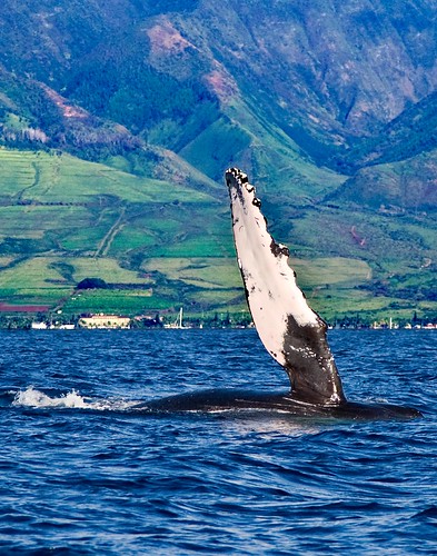


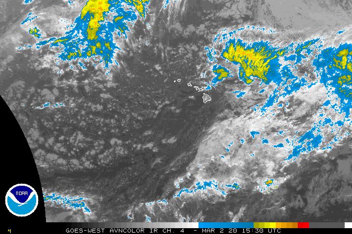