April 2006
Monthly Archive
Posted by Glenn
No Comments
April 19-20 2006
Air Temperatures – The following maximum temperatures were recorded across Hawaii Wednesday:
Lihue, Kauai – 78F
Honolulu, Oahu – 80
Kaneohe, Oahu – 78
Kahului, Maui – 81
Hilo, Hawaii – 79
Kailua-Kona, Hawaii – 83
Temperatures early Thursday morning ranged between these warmest and coolest spots near sea level at the 4 a.m. hour:
Kaneohe, Oahu – 72
Kalaeloa, Oahu – 66
Precipitation Totals – The following numbers represent the largest precipitation totals during the last 24 hours (as of Thursday morning) on each of the major islands, including:
0.75 MOUNT WAIALEALE, KAUAI
0.76 SOUTH FORK KAUKONAHUA, OAHU
0.04 MOLOKAI
0.00 LANAI
0.00 KAHOOLAWE
0.54 WEST WAILUAIKI, MAUI
0.65 PIIHONUA, BIG ISLAND
Weather Chart – Here’s the latest (automatically updated) weather map…showing a 1029 millibar high pressure system to the north of Hawaii. This cell of high pressure will keep moderate to locally strong and gusty strong trade winds blowing today through Friday. Here’s a Weather Map Symbol page for clarification about what all those funny weather symbols mean.
Hawaii’s Mountains – Here’s a link to the live webcam on the summit of near 14,000 foot Mauna Kea on the Big Island of Hawaii. The tallest peak on the island of Maui is the Haleakala Crater, which is near 10,000 feet in elevation. These two webcams are only available during the daylight hours here in the islands…that is unless there’s a big moon rising just after sunset for an hour or two!
Satellite Images – To view the cloud conditions we have here in Hawaii, please use the following satellite links, starting off with the Infrared Satellite Image of the islands to see all the clouds around the state during the day and night. This next image is one that gives close images of the islands only during the daytime hours, and is referred to as a Close-up visible image. This next image shows a larger view of the Pacific…giving perspective to the wider ranging cloud patterns in the Pacific Ocean…out from the islands. To help you keep track of where any showers may be around the islands, here’s the latest animated radar image.
Aloha Paragraphs
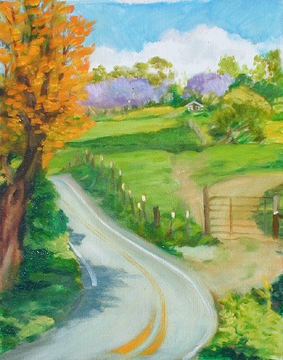
Silver Oak and Jacaranda trees…Upcountry Maui
Artist: Donald Jusko
The trade winds, which have been blowing all of April, will continue through Thursday. The latest forecast charts suggest that they will continue to grace the Hawaiian Islands through the end of the month. High pressure systems to the north through NE will be the source of these moderately strong breezes. They will blow 24 hours a day, although be lightest at night, and strongest during the days. Wind speeds will vary between 10-25 mph for the most part, although those locally windiest spots will have winds in gusts reaching up over the 30 mph mark. The NWS office in Honolulu will keep the small craft wind advisory going through Thursday. There’s nothing unusual about all of this, as it matches climatology quite well.
We continue to have quite a contrast between the windward and leeward sides of the islands. There has been, and will continue to be lots of warm sunshine beaming down on the south and west facing leeward beaches, forcing air temperatures well up into the 80F’s. The cooler north and east facing windward sections will have high temperatures restricted to the 70F’s. Overnight low temperatures won’t vary much between the two sides of the islands, ranging between around 68F to the lower 70F’s in general. By the way, those windward areas will continue to see off and on passing showers…which will turn out to be most generous during the night and early morning hours. Again, there’s nothing too unusual about any of this during the spring months here in the tropics.
A quick glance at weather maps, and satellite imagery, shows that Hawaii will continue to have rather pleasant weather. The one problem area may be all those showers of late along the windward sides…which have some areas rather soggy now! At any rate, with cold fronts staying well north of here, we see no intrusions of rainy weather entering our area from the middle latitudes of the north Pacific Ocean. Eyeballing the area south of the islands, in the deeper tropics, I don’t anticipate any moisture coming up from down there either. It’s too early in the year to even be thinking about any tropical storms arriving from the east…which leaves us with just the trade winds to contend with.
It’s early Wednesday evening here in Kula, Maui, as I begin writing this sunset commentary. The other day I was writing about how beautiful the blooming Jacaranda trees were looking, along the road that I drive to get home after work each day. Right along beside them we find another tree called Silver Oaks, which aren’t actually silver colored, but rather more of a golden orange actually. The picture above shows both of these types of trees, which are currently maxing-out in their beautiful display of flowers right now. Especially during the early mornings and around sunset, with the lush green pastures behind…these trees are nothing short of spectacular! It’s just before sunset now, and before the sun sinks into a gray bank of clouds covering the West Maui Mountains (at least from here in Kula), there’s a golden glow bathing the inside of my weather tower. The temperature inside, with all the windows open, is 70F degrees, while outside its a bit cooler at 63F degrees. As is almost always the case, I was able to get down to the beach at lunch in Kihei, and as usual, it was such a treat to walk on the sand, and then to dive into the clear waters of the warm Pacific Ocean. Unfortunately, I received a call from my sister this afternoon, informing me that my Dad is in the hospital again. I’m waiting to hear from my Mom about the nature of the situation, and it may necessitate a trip home soon. I hope everyone has a very pleasant Wednesday night, and that you will be inclined to meet me here again early Thursday morning for the next weather narrative. Aloha for now…Glenn.
p.s. Here’s a link to one of the advertisers on the left hand margin: Lani Kai …Maui Vacation Rental, whose website says: “Brand new, fully remodeled, luxury vacation condo ideally located in sunny South Maui adjacent to some of Hawaii’s most beautiful beaches. Lani Kai, or “Heavenly Ocean†in Hawaiian, is your luxurious home base for exploring the best that Maui has to offer.â€
Posted by Glenn
No Comments
April 18-19 2006
Air Temperatures – The following maximum temperatures were recorded across Hawaii Tuesday:
Lihue, Kauai – 79F
Honolulu, Oahu – 82
Kaneohe, Oahu – 79
Kahului, Maui – 81
Hilo, Hawaii – 79
Kailua-Kona, Hawaii – 85
Temperatures early Wednesday morning ranged between these warmest and coolest spots near sea level at the 4 a.m. hour:
Kailua-kona – 75
Hilo airport – 65
Precipitation Totals – The following numbers represent the largest precipitation totals during the last 24 hours (as of Wednesday morning) on each of the major islands, including:
0.68 MOUNT WAIALEALE, KAUAI
0.94 POAMOHO 2, OAHU
0.60 MOLOKAI
0.00 LANAI
0.00 KAHOOLAWE
0.50 WEST WAILUAIKI, MAUI
1.07 MOUNTAIN VIEW, BIG ISLAND
Weather Chart – Here’s the latest (automatically updated) weather map…showing high pressure systems to the NE and NNW of Hawaii. This pressure configuration will keep moderate to locally strong and gusty strong trade winds blowing today through Thursday. Here’s a Weather Map Symbol page for clarification about what all those funny weather symbols mean.
Hawaii’s Mountains – Here’s a link to the live webcam on the summit of near 14,000 foot Mauna Kea on the Big Island of Hawaii. The tallest peak on the island of Maui is the Haleakala Crater, which is near 10,000 feet in elevation. These two webcams are only available during the daylight hours here in the islands…that is unless there’s a big moon rising just after sunset for an hour or two!
Satellite Images – To view the cloud conditions we have here in Hawaii, please use the following satellite links, starting off with the Infrared Satellite Image of the islands to see all the clouds around the state during the day and night. This next image is one that gives close images of the islands only during the daytime hours, and is referred to as a Close-up visible image. This next image shows a larger view of the Pacific…giving perspective to the wider ranging cloud patterns in the Pacific Ocean…out from the islands. To help you keep track of where any showers may be around the islands, here’s the latest animated radar image.
Aloha Paragraphs

Nice Hawaiian sunset…
The Hawaiian Islands, at least most areas, will continue to bask in warm sunshine. The greatest amount of these sun rays will be beaming down upon the south and west facing leeward beaches. These areas are where most of the famous resorts and condos are located. All these tanning rays will be sending our daytime air temperatures well up into the 80F’s…the mid to high 80F’s in those warmest spots. At the same time, the cooling trade winds will be blowing, helping to temper that afternoon heat.
The other sides of the islands, those north and east windward shores, will be cooler. The trade winds get into these areas more directly, moderating the heat quite a bit. At the same time, these winds are carrying clouds with them, so the shade from those clouds also helps to keep the temperatures down as well. We’ll continue to see some passing showers, falling most generously during the night and early morning hours…which help to keep the tropical vegetation lush and green.
These trade winds are very typical for the month of April, which in most ways mark the end of our winter weather systems. Climatologically speaking, the trade winds will continue blowing through the rest of April. The Hawaiian Islands are famous for their balmy breezes, setting us apart from other areas in the tropics, which don’t receive them. They are a true blessing, helping to keep our otherwise too hot weather, very comfortable. They are a cooling breeze, meant to set the coconut palm trees swaying!
You know, people often ask me: “after living in Hawaii for over 30 years, do you get used to seeing all that beauty Glenn?†The truth is that I don’t… every day I find so many things that catch my eye, which register as beautiful. I find that everywhere I look, there it is, that tropical beauty that keeps me looking all the time. I like looking down the mountain when I’m home, to see the ocean out there. When I’m at the ocean, there are those amazing greens and blues that catch the sunlight so magnificently. The palm trees too I just love, not to mention the Jacaranda trees on my drive home. It’s all simply splendid, and never fails to inspire me!
It’s early Tuesday evening here in Kula, Maui, as I start today’s sunset commentary. I’m home a little early today, as I had my six month dermatology appointment. My Doctor, the esteemed George Martin, whose office is in Kihei, said I was doing quite well. He took a biopsy, and burned off three fairly minor little “pre-cancerous” lesions. As much time as I’ve spent in the sun, it’s always a relief when he doesn’t find anything more serious! Speaking of the sun, I was out in it during my lunch break today, and enjoyed the partly cloudy conditions I found in Kihei. There wasn’t much wind, and unfortunately not many waves either, although it was refreshing. There was a brief break in the windward showers this afternoon, but as I glance over towards Makawao and Haiku, there’s the next, in a near constant series of passing showers over that way. Haiku especially has had lots of showers, over a month’s worth by now, and those folks are experiencing soggy ground to say the least. Here in Kula, it’s nice and warm, with just a slight breeze blowing my wind chimes at the moment. It’s just perfect for ping pong, and if you’ll excuse me, I’m going to inquire whether my neighbor wants to ping some balls back and forth now. I’ll be back early Wednesday morning with the next narrative. I hope you have a good rest between now and then. Aloha for now…Glenn.
p.s. Here’s a link to one of the advertisers on the left hand margin: First Horizon Home Loans…sponsored by Chris Lum, who says: “I want to help you finance your home, and more . . . I want to build a relationship based on unparalleled service and personal attention.”
Posted by Glenn
No Comments
April 17-18 2006
Air Temperatures – The following maximum temperatures were recorded across Hawaii Monday:
Lihue, Kauai – 78F
Honolulu, Oahu – 81
Kaneohe, Oahu – 78
Kahului, Maui – 81
Hilo, Hawaii – 75
Kailua-Kona, Hawaii – 83
Temperatures early Tuesday morning ranged between these warmest and coolest spots near sea level at the 4 a.m. hour:
Kailua-kona – 73
Hilo airport – 66
Precipitation Totals – The following numbers represent the largest precipitation totals during the last 24 hours (as of Tuesday morning) on each of the major islands, including:
0.34 MOUNT WAIALEALE, KAUAI
0.39 SOUTH FORK KAUKONAHUA, OAHU
0.01 MOLOKAI
0.00 LANAI
0.00 KAHOOLAWE
0.65 WEST WAILUAIKI, MAUI
0.94 GLENWOOD, BIG ISLAND
Weather Chart – Here’s the latest (automatically updated) weather map…showing high pressure systems to the NE and NW of Hawaii. This pressure configuration will keep moderate to locally strong and gusty strong trade winds to blow today…slightly lighter Wednesday. Here’s a Weather Map Symbol page for clarification about what all those funny weather symbols mean.
Hawaii’s Mountains – Here’s a link to the live webcam on the summit of near 14,000 foot Mauna Kea on the Big Island of Hawaii. The tallest peak on the island of Maui is the Haleakala Crater, which is near 10,000 feet in elevation. These two webcams are only available during the daylight hours here in the islands…that is unless there’s a big moon rising just after sunset for an hour or two!
Satellite Images – To view the cloud conditions we have here in Hawaii, please use the following satellite links, starting off with the Infrared Satellite Image of the islands to see all the clouds around the state during the day and night. This next image is one that gives close images of the islands only during the daytime hours, and is referred to as a Close-up visible image. This next image shows a larger view of the Pacific…giving perspective to the wider ranging cloud patterns in the Pacific Ocean…out from the islands. To help you keep track of where any showers may be around the islands, here’s the latest animated radar image.
Aloha Paragraphs

Jacaranda Tree in upcountry east Maui…going up Crater Road
This new week starts off with the rather stiff trade winds still blowing across the Hawaiian Islands. A long lasting near 1030 millibar high pressure system remains well established to the north of here. These trade winds will be strong though to continue the small craft wind advisory in those windiest locations, especially around Maui and the Big Island. The latest computer forecast models show these breezy trade winds sticking around through the next week to 10 days…at least.
This will likely keep the trade winds blowing through the end of this month. Meanwhile, there are no signs of organized rain storms approaching from any direction. Although that doesn’t mean that there won’t be some showers around. The windward sides of the islands will continue to see occasional passing showers. The leeward sides will find dry conditions for the most part, with lots of sunny weather. The Kona coast on the Big Island might find a few late afternoon showers.
This more or less fair weather outlook is par for the course, as the second half of April is often quite nice. It’s very typical to have this kind of trade wind weather pattern, which often stretches right on into the months of May and June. The next major shift in the weather will occur during the summer months, when the 2006 hurricane season begins, starting on June 1 here in the central Pacific Ocean. It’s still too early to project too much about what this year’s hurricane season will look like though.
As is almost always the case during the spring months, the beaches are often quieter during the morning hours. I’m referring to the nature of the trade winds, and how they are lighter in the night and morning hours. They crank-up during the afternoon hours, with rougher water along the coasts. The afternoons can be fine, it just depends upon the wind direction and speed at any particular beach. My personal preference is when the trade winds are softer, and the ocean is nice an glassy smooth during the mornings.
It’s early Monday evening as I begin today’s sunset commentary. I hope you noticed the picture of the Jacaranda tree above. I’ve been watching these trees for about the last month, wondering when they were going to reach their peak…in terms of their glorious color. As I was driving home just now, on the very road you see in that picture, which is the one I drive on each day coming home from work, I decided they were just too beautiful not to mention them now. I may very well try and find some other pictures over the next couple of days, and speak about them a bit more then. If you’ve ever seen them in full bloom, they are just so wonderful, as they contrast with the deep green of the pasture grass on the slopes of the Haleakala Crater. It’s a special time of year when these trees flair up in color. They drop their blossoms on the road, which you can see in the picture above as well. By the way, there isn’t just one, rather they are stretched up the road for many miles, and are dotting the landscape here in Kula too. As I look out my weather tower window, I can see several, which stand out so well against the otherwise evergreen tropical vegetation, including lots of avocado trees…which are loaded with fruit at the moment! I’ve been eating lots of guacamole lately, made with the avo’s from right here on this property. I’m feeling pretty mellow this evening, after a good day’s work, punctuated at lunch with a quick beach walk and ocean swim. I hope you have a great Monday! I’ll be back early Tuesday morning with the next new narrative. Aloha for now…Glenn.
p.s. Here’s a link to one of the advertisers on the left hand margin: DKL…DK Levin Company, who has quietly become recognized as one of the premier accounting firms on the island of Maui.
Posted by Glenn
No Comments
April 16-17 2006
Air Temperatures – The following maximum temperatures were recorded across Hawaii Sunday:
Lihue, Kauai – 79F
Honolulu, Oahu – 81
Kaneohe, Oahu – 78
Kahului, Maui – 79
Hilo, Hawaii – 77
Kailua-Kona, Hawaii – 84
Temperatures early Monday morning ranged between these warmest and coolest spots near sea level at the 4 a.m. hour:
Lihue, Kauai – 73
Hilo airport – 67
Precipitation Totals – The following numbers represent the largest precipitation totals during the last 24 hours (as of Monday morning) on each of the major islands, including:
0.64 MOUNT WAIALEALE, KAUAI
0.10 KAWAILOA, OAHU
0.05 MOLOKAI
0.00 LANAI
0.00 KAHOOLAWE
0.94 WEST WAILUAIKI, MAUI
1.07 GLENWOOD, BIG ISLAND
Weather Chart – Here’s the latest (automatically updated) weather map…showing a 1029 millibar high pressure system to the north of Hawaii. This high pressure cell will cause moderate to locally strong and gusty strong trade winds to blow today…slightly lighter Tuesday. Here’s a Weather Map Symbol page for clarification about what all those funny weather symbols mean.
Hawaii’s Mountains – Here’s a link to the live webcam on the summit of near 14,000 foot Mauna Kea on the Big Island of Hawaii. The tallest peak on the island of Maui is the Haleakala Crater, which is near 10,000 feet in elevation. These two webcams are only available during the daylight hours here in the islands…that is unless there’s a big moon rising just after sunset for an hour or two!
Satellite Images – To view the cloud conditions we have here in Hawaii, please use the following satellite links, starting off with the Infrared Satellite Image of the islands to see all the clouds around the state during the day and night. This next image is one that gives close images of the islands only during the daytime hours, and is referred to as a Close-up visible image. This next image shows a larger view of the Pacific…giving perspective to the wider ranging cloud patterns in the Pacific Ocean…out from the islands. To help you keep track of where any showers may be around the islands, here’s the latest animated radar image.
Aloha Paragraphs

Hamoa Beach, Maui
Photo: Douglas Peebles
The trade winds remain a near-permanent part of our Hawaiian Island weather picture. This is thanks to a long lasting high pressure system, which remains nearly stationary far to the north of the Hawaiian Islands Sunday. Wind speeds will vary in strength, in general though, we’ll have rather breezy winds blowing across the Aloha state. These trade winds will range between about 10-25 overall, with gusts topping the 30 mph mark at times. The NWS forecast office in Honolulu is keeping the small craft advisory active across most of the coastal waters, and the major channels.
The latest computer forecast model output shows these trade winds blowing on this Easter Sunday, through the new week ahead. We should see them easing up a little starting Monday, bottoming-out in strength by Tuesday. They will continue to fan the islands right through next week as well…gaining strength again by Wednesday. As I’ve been pointing out the last few days, this is all pretty normal for this time of year. The spring, and summer months too, are well known for having breezy trade wind weather. Climatology would have us believe that this breezy air will stick around well into the future.
The windward sides will continue to see some passing shower activity. This too is quite common during the month of April. Those north and east facing shores and slopes have been rather moist the last coupld of weeks…although most of it has been rather light. The leeward beaches in contrast have been mostly dry…and will stay that way. Sunday and Monday will remain nice, especially along those resort beaches, where mostly sunny to partly cloudy weather will promote lots of tanning.
It’s early Sunday evening here in Kula, Maui, as I start this pre-sunset commentary. It was peaceful day here on Maui, at least from what I could see. A friend and I went kayaking and snorkeling on the south shore. It didn’t turn out to be one of our better days, for a number of reasons. The strong and gusty trade winds made the area we went to, choppy and full of white caps. The underwater visibilities weren’t that great along that part of the south coast, mostly because of the small SW swell waves breaking. We had lunch at a little fish and french fries place on South Kihei Road. I love sitting out and people watching sometimes, there was quite an array of different kinds of folks out and about, on this Easter Sunday. At the moment, the warm sunshine is flooding into this open windowed weather tower of mine. It feels so warm, and as I write, I’m sipping on a little something…a glass of Montepulciano, D’Abruzzo, 2003…in pure celebration of this major holiday! Here’s wishing you the most pleasant Sunday night, and a fresh invitation to join me here again Monday morning. I’m off to find a sunset ping pong partner, bye for now…Glenn.
Posted by Glenn
No Comments
April 15-16 2006
Air Temperatures – The following maximum temperatures were recorded across Hawaii Saturday:
Lihue, Kauai – 79F
Honolulu, Oahu – 81
Kaneohe, Oahu – 78
Kahului, Maui – 80
Hilo, Hawaii – 76
Kailua-Kona, Hawaii – 84
Temperatures early Sunday morning ranged between these warmest and coolest spots near sea level at the 5 a.m. hour:
Kaneohe, Oahu – 73
Hilo airport – 66
Precipitation Totals – The following numbers represent the largest precipitation totals during the last 24 hours (as of Sunday morning) on each of the major islands, including:
0.82 MOUNT WAIALEALE, KAUAI
0.26 NUUANU UPPER, OAHU
0.07 MOLOKAI
0.00 LANAI
0.00 KAHOOLAWE
0.43 WEST WAILUAIKI, MAUI
1.41 GLENWOOD, BIG ISLAND
Weather Chart – Here’s the latest (automatically updated) weather map…showing a 1032 millibar high pressure system to the north of Hawaii. This high pressure cell will cause moderate to locally strong and gusty strong trade winds to blow Sunday into Tuesday. Here’s a Weather Map Symbol page for clarification about what all those funny weather symbols mean.
Hawaii’s Mountains – Here’s a link to the live webcam on the summit of near 14,000 foot Mauna Kea on the Big Island of Hawaii. The tallest peak on the island of Maui is the Haleakala Crater, which is near 10,000 feet in elevation. These two webcams are only available during the daylight hours here in the islands…that is unless there’s a big moon rising just after sunset for an hour or two!
Satellite Images – To view the cloud conditions we have here in Hawaii, please use the following satellite links, starting off with the Infrared Satellite Image of the islands to see all the clouds around the state during the day and night. This next image is one that gives close images of the islands only during the daytime hours, and is referred to as a Close-up visible image. This next image shows a larger view of the Pacific…giving perspective to the wider ranging cloud patterns in the Pacific Ocean…out from the islands. To help you keep track of where any showers may be around the islands, here’s the latest animated radar image.
Aloha Paragraphs

Sunset in Hawaii…
Photo: Douglas Peebles
The trade winds remain a semi-permanent part of our Hawaiian Island weather picture. This is thanks to a long lasting high pressure system, which remains nearly stationary far to the north of the Hawaiian Islands Saturday. Wind speeds will vary in strength, in general though, we’ll have rather strong and gusty winds blowing across the Aloha state. These breezy trade winds will range between about 10-25 overall, with gusts topping the 30 mph mark at times. The NWS forecast office in Honolulu is keeping the small craft advisory active across most of the coastal waters, and the major channels.
The latest computer forecast model output shows these trade winds blowing today through the weekend. We should see them easing up a little starting Sunday, bottoming-out in strength by Tuesday. They will continue to fan the islands right through next week as well…gaining strength again by Wednesday. As I’ve been pointing out the last few days, this is all pretty normal for this time of year. The spring, and summer months too, are well known for having breezy trade wind weather. Climatology would have us believe that this breezy air will stick around well into the future.
The windward sides will continue to see some passing shower activity. This too is very common during the month of April. Those north and east facing shores and slopes have been quite moist so far this week…although most of it has been rather light. The leeward beaches in contrast have been mostly dry…and will stay that way. Saturday and Sunday will remain nice, especially along those resort beaches, where mostly sunny weather will promote lots of tanning. It would be wise to use a sun screening agent, and take your time getting that cherished tan.
It’s early Saturday evening as I start writing my sunset commenty. Isn’t that picture of the day pretty up above! I love the sunset colors, they vary from day to day, which is like the weather itself. I’m often called the Weatherman, like out in the water today by a fellow surfer. I’ve seen this person there before, and he’s always sort of chuckling to himself, and those that he knows in the surf line. He’s a good surfer, someone that lives here on Maui. I wanted to surf 1000 peaks, but it was too windy there, and the waves were small. I kept driving to a spot called Olowalu, parked, and watched it for size and shape…while I listened to the news on NPR. I like to hear Daniel Shore and Scott Simon dialogue about the news events of the prior week. I got one or two decent rides, before the sideshore wind came up, driving me back to shore. I needed a few things, so I made the drive over to Mana Foods in Paia. Then the drive up the mountain to Kula. I was able to wash my clothes, dry them on the line…there was that much available sunshine this afternoon. I’m sipping on a nice glass of Castle Rock Pinot Noir this evening, which was a nice thing to have during sunset out on my weather deck. I’ll be getting up early Sunday morning, in order to update these webpages before having breakfast and going Kayaking thereafter. I hope you have a great Saturday night! Aloha for now…Glenn.
Posted by Glenn
[5] Comments
April 14-15 2006
Air Temperatures – The following maximum temperatures were recorded across Hawaii Friday:
Lihue, Kauai – 78F
Honolulu, Oahu – 80
Kaneohe, Oahu – 77
Kahului, Maui – 82
Hilo, Hawaii – 78
Kailua-Kona, Hawaii – 84
Temperatures early Saturday morning ranged between these warmest and coolest spots near sea level at the 5 a.m. hour:
Kailua-kona – 74
Hilo airport – 64
Precipitation Totals – The following numbers represent the largest precipitation totals during the last 24 hours (as of Saturday morning) on each of the major islands, including:
0.75 MOUNT WAIALEALE, KAUAI
0.15 MANOA LYON ARBORETUM, OAHU
0.00 MOLOKAI
0.00 LANAI
0.00 KAHOOLAWE
0.44 WEST WAILUAIKI, MAUI
0.46 PIIHONUA, BIG ISLAND
Weather Chart – Here’s the latest (automatically updated) weather map…showing a 1031 millibar high pressure system to the north of Hawaii. This high pressure cell will cause moderate to locally strong and gusty strong trade winds to blow Saturday into Sunday. Here’s a Weather Map Symbol page for clarification about what all those funny weather symbols mean.
Hawaii’s Mountains – Here’s a link to the live webcam on the summit of near 14,000 foot Mauna Kea on the Big Island of Hawaii. The tallest peak on the island of Maui is the Haleakala Crater, which is near 10,000 feet in elevation. These two webcams are only available during the daylight hours here in the islands…that is unless there’s a big moon rising just after sunset for an hour or two!
Satellite Images – To view the cloud conditions we have here in Hawaii, please use the following satellite links, starting off with the Infrared Satellite Image of the islands to see all the clouds around the state during the day and night. This next image is one that gives close images of the islands only during the daytime hours, and is referred to as a Close-up visible image. This next image shows a larger view of the Pacific…giving perspective to the wider ranging cloud patterns in the Pacific Ocean…out from the islands. To help you keep track of where any showers may be around the islands, here’s the latest animated radar image.
Aloha Paragraphs

The perfect beach…
The trade winds have become a permanent fixture in our Hawaiian Island weather picture. This is thanks to a long lasting high pressure system, which remains nearly stationary far to the north of the Hawaiian Islands Friday. Wind speeds will vary in strength, in general though, we’ll have rather strong and gusty winds blowing across the Aloha state. These breezy trade winds will range between about 10-25 overall, with gusts topping the 30 mph mark at times. Those windiest spots around the state will find gusts to 40-50 mph. The NWS forecast office in Honolulu is keeping the small craft advisory active across most of the coastal waters, and the major channels.
The latest computer forecast model output shows these trade winds blowing today through the weekend. We should see them easing up a little starting Sunday. They will continue to fan the islands right through next week as well. As I’ve been pointing out the last few days, this is all pretty normal for this time of year. The spring, and summer months too, are well known for having breezy trade wind weather. Climatology would have us believe that this breezy air will stick around well into the future.
The windward sides will continue to see some passing shower activity. This too is very common during the month of April. Those north and east facing shores and slopes have been quite moist so far this week…although most of it has been rather light. The leeward beaches in contrast have been mostly dry…and will stay that way. Friday and Saturday will remain nice, especially along those resort beaches, where mostly sunny weather will promote lots of tanning. It would be wise to use a sun screening agent, and take your time getting that cherished tan.
It’s early Friday evening as I begin today’s sunset commentary. I took off work a few minutes early today, and jammed up to Kula, grabbed my skateboard, and drove another 15 minutes up towards the Haleakala Crater. I pulled over below the entrance to the National Park, and found that they had recently repaved the road. The road was brand new, and thus perfect for riding down. I hadn’t done this fun activity for quite some time, so I eased into it slowly. I skate down this one nice long section, and then walk back up, over and over. I have to keep pulling over when cars come down or up, but at that time of day, there aren’t many. The fog kept rolling over the road and then clearing, and as I was the only one up there…it was kind of a neat feeling. I didn’t fall, which was a relief, although I sort of tweaked the heel of one foot, and can feel the right side of my hip too. I’m gonna start doing that more often, now that I can pull it off after work…as the sun sets later now. I got to the beach today at lunch, and found good bodysurfing waves, which really makes my day! Since there are waves breaking on the leeward beaches, I’m going to take the drive over to the Lahaina side Saturday morning. I’ll be up early updating this website before I leave. I hope you have a great Friday night! Aloha for now…Glenn.
Posted by Glenn
[4] Comments
April 13-14 2006
Air Temperatures – The following maximum temperatures were recorded across Hawaii Thursday:
Lihue, Kauai – 78F
Honolulu, Oahu – 80
Kaneohe, Oahu – 86
Kahului, Maui – 79
Hilo, Hawaii – 73
Kailua-Kona, Hawaii – 84
Temperatures early Friday morning ranged between these warmest and coolest spots near sea level at the 5 a.m. hour:
Kailua-kona – 75
Hilo airport – 65
Precipitation Totals – The following numbers represent the largest precipitation totals during the last 24 hours (as of Friday morning) on each of the major islands, including:
0.45 MOUNT WAIALEALE, KAUAI
0.01 KAHUKU, OAHU
0.00 MOLOKAI
0.00 LANAI
0.00 KAHOOLAWE
0.31 WEST WAILUAIKI, MAUI
0.88 GLENWOOD, BIG ISLAND
Weather Chart – Here’s the latest (automatically updated) weather map…showing a 1034 millibar high pressure system to the north of Hawaii. This high pressure cell will cause moderate to locally strong and gusty strong trade winds to blow Friday into Saturday. Here’s a Weather Map Symbol page for clarification about what all those funny weather symbols mean.
Hawaii’s Mountains – Here’s a link to the live webcam on the summit of near 14,000 foot Mauna Kea on the Big Island of Hawaii. The tallest peak on the island of Maui is the Haleakala Crater, which is near 10,000 feet in elevation. These two webcams are only available during the daylight hours here in the islands…that is unless there’s a big moon rising just after sunset for an hour or two!
Satellite Images – To view the cloud conditions we have here in Hawaii, please use the following satellite links, starting off with the Infrared Satellite Image of the islands to see all the clouds around the state during the day and night. This next image is one that gives close images of the islands only during the daytime hours, and is referred to as a Close-up visible image. This next image shows a larger view of the Pacific…giving perspective to the wider ranging cloud patterns in the Pacific Ocean…out from the islands. To help you keep track of where any showers may be around the islands, here’s the latest animated radar image.
Aloha Paragraphs

Breaching Humpback Whale…
The trade winds are here to stay, thanks to a long lasting high pressure system, which remains nearly stationary far to the north of the Hawaiian Islands. Wind speeds will vary in strength, between night and day, and also between morning and afternoons. In general though, we will have rather strong and gusty winds blowing across the Aloha state. These breezy trade winds will range between about 10-25 overall, with gusts topping the 30 mph mark at times. Those windiest spots around the state will find gusts to 40+ mph. In response, the NWS forecast office in Honolulu is keeping the small craft advisory active across most of the marine environment.
The latest computer forecast model output shows these trade winds blowing through the rest of this week. We should see them mellowing out a little as we move into the weekend time frame. They will continue to fan the islands right through next week as well. As I’ve been pointing out the last few days, this is all pretty normal for this time of year. The spring, and summer months too, are well known for having breezy trade wind weather. All this wind keeps the coconut palm trees swaying to and fro, as well as keeping the ocean surrounding the islands, chopped-up with white caps.
The windward sides will continue to see some passing shower activity. This too is very common during the month of April. Those north and east facing shores and slopes have actually been quite moist so far this week. It appears that the showers will finally start to ease up some now. The leeward beaches, and I should say in contrast, have been mostly dry…and will stay that way. The one minor problem has been persistent high cloudiness, which has kept our Hawaiian sunshine from beaming down fully. This will still be around, but seems to have moved east enough now, that we should find sunnier weather.
It’s early Thursday evening as I begin this evening’s sunset commentary. It was a fully sunny day along the leeward sides of most of the islands today…really sunny! The windward sides in contrast, were partly to mostly cloudy, with light showers or misty drizzle falling. When I drove up the Haleakala Highway on the way home from work, there were rainbows galore on the Makawao and Haiku side of the road. This weather pattern, with its strong trade winds, are fairly typical for the month of April. Speaking of strong winds, the Kawaihae area on the Big Island had wind gusting to 51 mph during the afternoon hours. Here on Maui, there were gusts over 40 mph at Maalaea Bay at times. I just love that picture of the breaching whale above, it really captures the flight and power that these amazing creatures exhibit when they’re “doing their thang.” They are mostly gone now, but a few loners are still around in places. This last weekend I saw only one, so most of them have left, heading up to Alaska for the summer. I got down to the beach today, and found the waters to be very clean and clear, and seasonably warm too. I hope you had a great day wherever you happened to have spent it. I’ll be back with the Friday edition of this narrative early in the morning, at least here in the islands, and hope that you will join me here again then. Aloha for now…Glenn
P.S. As a way of thanking my link advertisers, and to draw your attention to their good services…I’m highlighting each of them individually now. They can be found on the left hand margin of all my webpages. Today’s business is Hana Botanicals…CC Isole is the Proprietor. “HANA BOTANICALS Island Soaps and Bath Essentials is your Island Gift Source! Handmade in their Maui studio, you’ll love the quality offering of candles, soaps, lotions, gels, balms, body oils, incense, and gift baskets. Mention that you saw them here on this site, and CC will give you a 10% discount on your order.”
Posted by Glenn
[2] Comments
April 12-13 2006
Air Temperatures – The following maximum temperatures were recorded across Hawaii Wednesday:
Lihue, Kauai – 79F
Honolulu, Oahu – 80
Kaneohe, Oahu – 78
Kahului, Maui – 76
Hilo, Hawaii – 81
Kailua-Kona, Hawaii – 83
Temperatures early Thursday morning ranged between these warmest and coolest spots near sea level at the 4 a.m. hour:
Lihue airport, Kauai – 72
Hilo airport – 67
Precipitation Totals – The following numbers represent the largest precipitation totals during the last 24 hours (as of Thursday morning) on each of the major islands, including:
1.59 MOUNT WAIALEALE, KAUAI
0.99 MANOA LYON ARBORETUM, OAHU
0.15 MOLOKAI
0.00 LANAI
0.00 KAHOOLAWE
2.34 WEST WAILUAIKI, MAUI
1.04 HILO AIRPORT, BIG ISLAND
Weather Chart – Here’s the latest (automatically updated) weather map…showing a 1036 millibar high pressure system to the north of Hawaii. This high pressure cell will cause moderate to locally strong and gusty strong trade winds to blow Wednesday through Thursday. Here’s a Weather Map Symbol page for clarification about what all those funny weather symbols mean.
Hawaii’s Mountains – Here’s a link to the live webcam on the summit of near 14,000 foot Mauna Kea on the Big Island of Hawaii. The tallest peak on the island of Maui is the Haleakala Crater, which is near 10,000 feet in elevation. These two webcams are only available during the daylight hours here in the islands…that is unless there’s a big moon rising just after sunset for an hour or two!
Satellite Images – To view the cloud conditions we have here in Hawaii, please use the following satellite links, starting off with the Infrared Satellite Image of the islands to see all the clouds around the state during the day and night. This next image is one that gives close images of the islands only during the daytime hours, and is referred to as a Close-up visible image. This next image shows a larger view of the Pacific…giving perspective to the wider ranging cloud patterns in the Pacific Ocean…out from the islands. To help you keep track of where any showers may be around the islands, here’s the latest animated radar image.
Aloha Paragraphs

Beautiful Maui sunset
The trade winds continue to be the primary mover and shaker in the Hawaiian Island weather picture now. A 1036 millibar high pressure system, far to the north of the Aloha state, is the source of this brisk trade wind flow of air. The latest computer forecast models suggest that this high pressure cell will remain in the same location, more or less, through the rest of this week. This will keep alive the moderate to locally strong and gusty trade winds. The small craft wind advisory for many coastal areas across the state, including the major channels, will remain in force through this period.
As I was mentioning in yesterday’s narrative, this is common stuff during the spring months of the year. Wind speeds will range between about 10-25 mph, with some gusts topping 30 mph in places. If these trade winds get as strong and gusty as expected, we could see winds gusting up towards the 40 mph mark, or even above that in those locally windiest locations…particularly around Maui and the Big Island. The physical terrain features, such as channels and valleys, can often enhance or accelerate the wind flow, which is usually where the strongest winds blow in Hawaii.
All this trade wind action will help to carry moist clouds towards the windward coasts and slopes. These north and east facing windward shores will see passing showers at times, especially during the nights and early morning hours. These showers are being generated by what we call the orographic effect, which simply means that moisture is forced up the sides of the volcanic slopes by the trade winds…where it cools and condenses into clouds. These clouds are then coaxed to drop showers, which of course help to keep the lush tropical vegetation alive and well there.
The latest satellite images show considerable clouds taking aim on those windward sides of the islands. Those same pictures show a fair amount of higher cirrus clouds around too, which will help to dim and filter our Hawaiian sunshine at times. These cirrus clouds will depart our area over the next day or two. At any rate, the south and west facing leeward sides of the islands will see much less showery weather, with many beaches remaining completely dry. The strong trade winds may blow a few showers over into the leeward areas on the smaller islands. Oahu is a good example of this…where stray showers can reach into Honolulu at times. The Kona slopes on the Big Island may see a few afternoon showers as well.
It’s early Wednesday evening here in Kula, Maui, as I begin today’s sunset commentary. Geez, can we ever get rid of this prolonged period of high cloudiness? Well, the answer is yes, thank goodness! The good thing about this sun dimming stuff is that it doesn’t drop rain. However, and as any bonafide sun worshipper will tell you…it definitely cuts into the tanning time greatly. The satellite image that I provided you in the paragraph above, shows just how extensive this cirrus cloudiness is at the moment. At the same time, the windward sides have had to put up with lots of passing showers lately, most of them haven’t been heavy ones, but nonetheless, it has kept a good measure of dampness around for most of this week so far. I do see less showers along those windward sides later Thursday through Friday, with a break in the high clouds for all other areas happening soon too. It may have just been my mood, but then again it may have been the extensive cloudiness, which kept me off the beach today. I got my take out food at the health food store, and then drove down to Cove Park and ate it while gazing out at the ocean. There certainly weren’t any waves to ride in my mind, as it was nearly flat as a pancake! I hope you have a great Wednesday night wherever you happen to be spending it! Like clockwork, I’ll be back early Thursday morning with the next updated narrative. Aloha for now…Glenn.
P.S. As a way of thanking my link advertisers, and to draw your attention to their good services…I’m highlighting each of them individually now. They can be found on the left hand margin of all my webpages. Today’s business is My Maui Condos…owned by Troy and Susan McCasland. Their website says: “In a quiet neighborhood near some of the best beaches on Maui your tropical home-away-from-home awaits you. Here, you’ll wake up to birds singing, and the sweet scent of exotic flowers. The sound of waves lapping on Charlie Young’s Beach beckons you for a short stroll down to the sea to swim and sun bathe on what has been called the best beach on Maui. On a 1/4 acre of lush tropical landscaping in South Kihei lies exotic, tropical bliss; just 100 yards away is Charlie Young Beach on the North end Kamaole Beach I.”
Posted by Glenn
[7] Comments
April 11-12 2006
Air Temperatures – The following maximum temperatures were recorded across Hawaii Tuesday:
Lihue, Kauai – 77F
Honolulu, Oahu – 80
Kaneohe, Oahu – 77
Kahului, Maui – 80
Hilo, Hawaii – 77
Kailua-Kona, Hawaii – 82
Temperatures early Wednesday morning ranged between these warmest and coolest spots near sea level at the 4 a.m. hour:
Kailua-kona – 73
Kahului airport – 69
Precipitation Totals – The following numbers represent the largest precipitation totals during the last 24 hours (as of Wednesday morning) on each of the major islands, including:
0.92 MOUNT WAIALAELAE, KAUAI
1.23 SOUTH FORK KAUKONAHUA, OAHU
0.23 MOLOKAI
0.00 LANAI
0.00 KAHOOLAWE
1.07 WEST WAILUAIKI, MAUI
0.95 GLENWOOD, BIG ISLAND
Weather Chart – Here’s the latest (automatically updated) weather map…showing a high pressure system to the north of Hawaii. This pressure configuration will cause moderately strong trade winds to blow Tuesday through Wednesday…strong and gusty at times. Here’s a Weather Map Symbol page for clarification about what all those funny weather symbols mean.
Hawaii’s Mountains – Here’s a link to the live webcam on the summit of near 14,000 foot Mauna Kea on the Big Island of Hawaii. The tallest peak on the island of Maui is the Haleakala Crater, which is near 10,000 feet in elevation. These two webcams are only available during the daylight hours here in the islands…that is unless there’s a big moon rising just after sunset for an hour or two!
Satellite Images – To view the cloud conditions we have here in Hawaii, please use the following satellite links, starting off with the Infrared Satellite Image of the islands to see all the clouds around the state during the day and night. This next image is one that gives close images of the islands only during the daytime hours, and is referred to as a Close-up visible image. This next image shows a larger view of the Pacific…giving perspective to the wider ranging cloud patterns in the Pacific Ocean…out from the islands. To help you keep track of where any showers may be around the islands, here’s the latest animated radar image.
Aloha Paragraphs

Hula Dancers
A routine trade wind weather pattern remains well established in the Hawaiian Islands now. A moderately strong high pressure system, far to the north of the Aloha state, is the source of the moderate to fresh trade wind flow. These breezy trade winds will keep moderate to fresh winds flowing across our latitudes of the central north Pacific well out into the future…at least through the end of this week. The NWS forecast office in Honolulu has a small craft advisory in force for all the channels, and most coastal waters.
These trade winds will remain the primary weather element influencing our weather. They may become quite strong and gusty over the next couple of days. As usual, there will be those spots that physical terrain features will enhance the wind speeds. We can think in terms of 10-25 mph in general, with the top gusts moving well up into the 30 mph range…even getting near 40 mph in those most gusty areas, on or around a few places on Maui and the Big Island. This is somewhat windier than usual, although nothing to worry about.
All this windy weather will carry some moist clouds to the north and east facing slopes and coasts at times. However, the overlying atmosphere is rather day and stable. This fact will limit precipitation coverage and intensity greatly. The south and west facing leeward beach areas will not see any of these showers. The Kona slopes may find a few afternoon showers, with a possible stray light shower spreading over into the leeward areas on the smaller islands at times. There may be an increase in windward showers Wednesday evening into Thursday, but again, all of this is common during the spring month of April…nothing to be concerned about.
It’s early Tuesday evening here in Kula, Maui, as I begin today’s sunset commentary. Despite the partly cloudy skies along the leeward sides today, there were enough breaks in the high clouds, that plenty of sunshine was able to grace the beaches at times. The windward coasts and slopes remained rather cloudy, with some light showers and drizzle in places. Back to the partly sunny beaches, they were quite lovely, with air temperatures zooming well up into the 80F’s. The sidewalks, and the sand leading down to the ocean were very warm on the bottom of my feet during my lunch break. The ocean was warm too, with exceptionally clear visibilities…reminding me of a fresh water swimming pool! Gosh I just love getting to the beach each early afternoon, it’s amazing how fresh and vitalized I come away feeling, after only 30-35 minutes or so. It’s just before sunset at the moment, with clouds covering this west facing slope of the Haleakala Crater. It’s not misting here, but there was lots of that towards Makawao and Haiku, as I drove through Pukalani on the way home from work. I hope you had a great day, and that you will have a peaceful Tuesday night as well. I’ll be back early Wednesday morning, with the next completely updated weather narrative. Aloha for now…Glenn.
P.S. As a way of thanking my link advertisers, and to draw your attention to their good services…I’m highlighting each of them individually now. They can be found on the left hand margin of all my webpages. Today’s business is Activities on Maui …owned by Kevin Ditamore. His website says: “Imagine how much better your vacation would be if you had a friend who lived here on Maui! They would give you advice about the best places to go to avoid the crowds. They would tell you the activities that were really worth doing. They would give you directions to hidden waterfalls. They would recommend restaurants that the locals know are good. Well, that is exactly why we are here! We don’t have customers … we have friends who come to visit. Let us share the spirit of ALOHA with you on your next vacation.”
Posted by Glenn
No Comments
April 10-11 2006
Air Temperatures – The following maximum temperatures were recorded across Hawaii Monday:
Lihue, Kauai – 76F
Honolulu, Oahu – 78
Kaneohe, Oahu – 75
Kahului, Maui – 80
Hilo, Hawaii – 79
Kailua-Kona, Hawaii – 85
Temperatures early Tuesday morning ranged between these warmest and coolest spots near sea level at the 4 a.m. hour:
Kailua-kona – 73
Hilo airport – 64
Precipitation Totals – The following numbers represent the largest precipitation totals during the last 24 hours (as of Tuesday morning) on each of the major islands, including:
1.68 MOUNT WAIALAELAE, KAUAI
0.18 WAIAWA,OAHU
0.08 MOLOKAI
0.00 LANAI
0.00 KAHOOLAWE
1.10 WEST WAILUAIKI, MAUI
0.34 LAUPAHOEHOE, BIG ISLAND
Weather Chart – Here’s the latest (automatically updated) weather map…showing a high pressure system to the north of Hawaii. This pressure configuration will cause moderately strong trade winds to blow Tuesday through Wednesday…strong and gusty at times. Here’s a Weather Map Symbol page for clarification about what all those funny weather symbols mean.
Hawaii’s Mountains – Here’s a link to the live webcam on the summit of near 14,000 foot Mauna Kea on the Big Island of Hawaii. The tallest peak on the island of Maui is the Haleakala Crater, which is near 10,000 feet in elevation. These two webcams are only available during the daylight hours here in the islands…that is unless there’s a big moon rising just after sunset for an hour or two!
Satellite Images – To view the cloud conditions we have here in Hawaii, please use the following satellite links, starting off with the Infrared Satellite Image of the islands to see all the clouds around the state during the day and night. This next image is one that gives close images of the islands only during the daytime hours, and is referred to as a Close-up visible image. This next image shows a larger view of the Pacific…giving perspective to the wider ranging cloud patterns in the Pacific Ocean…out from the islands. To help you keep track of where any showers may be around the islands, here’s the latest animated radar image.
Aloha Paragraphs

Hawaiian Bananas still on the tree
Photo: Douglas Peebles
The Hawaiian Islands will remain in a rather quick paced trade wind flow for the time being. These trade winds will spin-out of a moderately strong high pressure system to the north of here. The latest computer forecast models suggest that this trade wind producing high pressure cell will stay in place through the next week. The NWS forecast office in Honolulu has a small craft wind advisory in force over most Hawaiian waters through the end of this work week. Look for wind blowing in the 10-25 mph range, with those windiest spots finding winds gusting up over 30 mph at times.
This is all pretty common for the springtime month of April. It wouldn’t be unusual to see these breezy trade winds blowing through much of the rest of the month. They will be blowing on the strong side of the wind speed spectrum through the next several days. There’s the outside chance that those most windy spots, particularly around Maui and the Big Island, may see a wind advisory being issued. During these windy episodes, we can sometimes see wind gusts approach 40 mph, and even top that high number at times. All this “air in a hurry†will keep our local Hawaiian waters choppy with white caps, and the palm trees swaying over land.
Meanwhile, clouds being carried towards the islands on these trade winds, will continue to deposit some showers along the windward sides of the islands. There were off and on showers along those coastal slopes this past weekend, which will continue at times through the coming week…increasing some as the tail-end of old cold fronts bring more clouds then. The leeward sides will remain mostly dry, except on the smaller islands, where some showers may get carried over there on the gusty trade winds.
This latest satellite image shows that there is lots of sun dimming high clouds spreading over the islands now. This was the case Sunday as well, when there was lots of filtering of the sun, although which ended up giving a beautifully colorful sunset. These high clouds will stick around for the time being, providing muted sunshine. There will probably be some thin spots in the overcast, which will allow some sun too peek through here and there. It won’t be a solid overcast, so it won’t end up being too much of a problem, except for those folks who really want a mostly sunny day.
It’s early Monday evening here in Kula, Maui, as I start writing today’s sunset commentary. It was anything but a banner day for sunshine, as high clouds kept our tropical sun to a minimum in most areas. It was warm nonetheless, with short little blasts of solar radiation beaming down here and there. The latest models show these high clouds moving away over the next day or perhaps two. This will return us to our more normal sunny weather, especially along the leeward south and west facing beaches. Everyone is still a little nervous about clouds and rain returning, after such an onslaught if off and on rainy weather, hung on through most of the month of March. Please rest assured that just isn’t going to happen again anytime soon! I got to the beach today at lunch, and sure enough, it was very warm and pleasant. Despite the muted sunlight, it was still sunny enough to get a layer of tan, if that was what you were there for. I was there for a quick walk and dip in the ocean, which I managed quite nicely. It’s now just before sunset, and perhaps the high cirrus clouds may light up with some pink color in a few minutes…I’ll be watching. I hope you have a great Monday night! If you’re so inclined, please join me here again early Tuesday morning, as I’ll have a brand new narrative waiting for your reading pleasure then. Aloha for now…Glenn.
P.S. As a way of thanking my link advertisers, and to draw your attention to their good services…I’m highlighting each of them individually now. They can be found on the left hand margin of all my webpages. Today’s business is Dozzizart of Maui …art work by Michael Nardozzi~~~Although Michael had always possessed an insatiable craving for the ocean and its next swell (surfing until he was too tired to paddle another stroke), it wasn’t until Michael ventured beneath the ocean’s surface that he witnessed the real gift. He discovered the life and color and beauty of the Pacific that inspired him greatly. The yellow tangs, Moorish idols, clown fish, trigger fish, pencil urchins, sea turtles, crystal clear waters and intricate reef system energized him, as he feverishly began cutting, welding, sculpting and painting those images for others to enjoy. Check out his art work using the link to his site on the left hand margin of this page.
« Previous Page — Next Page »


