February 2009
Monthly Archive
Posted by Glenn
No Comments
February 28-March 1, 2009
Air Temperatures – The following maximum temperatures were recorded across the state of Hawaii Saturday afternoon:
Lihue, Kauai – 73
Honolulu, Oahu – 76
Kaneohe, Oahu – 74
Kahului, Maui – 76
Hilo, Hawaii – 73
Kailua-kona – 81
Air Temperatures ranged between these warmest and coolest spots near sea level – and on the highest mountains…at 5 p.m. Saturday evening:
Kailua-kona – 77F
Molokai airport – 68
Haleakala Crater – missing (near 10,000 feet on Maui)
Mauna Kea summit – 25 (near 14,000 feet on the Big Island)
Precipitation Totals – The following numbers represent the largest precipitation totals (inches) during the last 24 hours on each of the major islands, as of Saturday afternoon:
1.06 Mount Waialeale, Kauai
0.51 Oahu Forest NWR, Oahu
0.74 Molokai
0.24 Lanai
0.00 Kahoolawe
1.52 Puu Kukui, Maui
0.48 Kamuela Upper, Big Island
Weather Chart – Here’s the latest (automatically updated) weather map showing a very strong 1045 millibar high pressure system located far to the north-northwest of the islands. This high pressure system will cause cool, strong and gusty northeast winds Saturday and Sunday.
Satellite and Radar Images: To view the cloud conditions we have here in Hawaii, please use the following satellite links, starting off with the Infrared Satellite Image of the islands to see all the clouds around the state during the day and night. This next image is one that gives close images of the islands only during the daytime hours, and is referred to as a Close-up visible image. This next image shows a larger view of the Pacific…giving perspective to the wider ranging cloud patterns in the Pacific Ocean. Finally, here’s a looping IR satellite image, making viewable the clouds around the islands 24 hours a day. To help you keep track of where any showers may be around the islands, here’s the latest animated radar image.
Hawaii’s Mountains – Here’s a link to the live webcam on the summit of near 14,000 foot Mauna Kea on the Big Island of Hawaii. The tallest peak on the island of Maui is the Haleakala Crater, which is near 10,000 feet in elevation. These two webcams are available during the daylight hours here in the islands…and when there’s a big moon rising just after sunset for an hour or two! Plus, during the nights and early mornings you will be able to see stars, and the sunrise too…depending upon weather conditions.
Aloha Paragraphs

Windward showers, windy…cool
Winter weather continues to influence our Hawaiian Islands, with strong and gusty, and cool northeast winds. Looking at this latest weather map, we find an unusually strong, 1045 millibar high pressure system in the area north-northwest of Hawaii Saturday evening. These blustery NE winds, with their associated wind chill, will keep cooler than normal weather in place. The NWS in Honolulu has small craft wind advisories active across all of Hawaii’s coasts and channel waters, along with a high surf advisory for surf breaking along our east facing beaches. The NWS office issued a wind advisory for the entire state of Hawaii…from sea level all the way up over the tallest mountain on Maui. In addition to all of this, we find a gale warning in the Alenuihaha Channel between Maui and the Big Island.
NWS wind advisory: STRONG NORTHEAST WINDS OF 15 TO 30 MPH WITH GUSTS TO 50 MPH WILL CONTINUE THROUGH SUNDAY MORNING. THE HIGHEST WIND SPEEDS WILL OCCUR WHERE THE WIND BLOWS THROUGH VALLEYS, OVER RIDGES, AROUND HEADLANDS AND DOWNSLOPE ON THE SOUTHWEST, LEEWARD SIDES OF THE ISLANDS. THE STRONGEST WINDS MAY BE VERY LOCALIZED.
Showers will fall at times along the windward coasts and slopes…carried over into the leeward sides at times on the gusty winds. The showers arriving along the north and east sides of the islands, will generally be of the small drop variety. There will be periods of gray clouds and quickly passing drizzle and mist, and that cool air along the windward sides…with high temperatures restricted to the 70F’s. This cooler than normal weather will remain anchored over the islands through the next several days.
The strong and gusty NE winds will be by far…the most influential weather feature everywhere this weekend. The winds are generally the lightest during the morning hours, which increase during the late morning through early evening hours. The following numbers represented the strongest gusts (mph) on each of the islands at around 7pm Saturday evening:
Kauai: 37
Oahu: 33
Molokai: 40
Maui: 40
Kahoolawe: 35
Lanai: 39
Big Island: 44
It’s early Saturday evening here in Kula, Maui, as I begin writing this last section of today’s weather narrative. As noted in the paragraphs above, the cool weather is hanging on over us, having caught all of our attention. This weekend will be unusually cool and windy, with passing light showers at times too…although most of those will occur along our windward sides. As we move into the new week ahead, we will continue to see the windy weather, making for inordinately blustery weather in many places across the Aloha State.
The one positive spin that I can find to talk about, will be warmer air ahead…although it will take several more days before we break into it. The problem will continue to be the cool weather, as the air comes at us from further north than usual…riding in on the northeast winds. It may take until around mid-week, for our winds to veer around to the ENE or even the more classic easterly direction. This will be the signal for warmer weather, and the tail-end of the cool blustery conditions that will accompany us until then.
Let’s bring our attention back to the clouds that are racing along in this brisk wind flow. There may be some minor enhancement of the showery clouds that are bringing moisture to our windward sides Saturday evening. As this looping satellite image shows, we have quite a few cloud lines, or shower bands, being pushed our way on the winds. These will bring those passing showers. At the same time, we see high clouds being carried our way on the higher level winds, coming in from the west. These cirrus clouds will dim and filter our sunshine at times too.
At a little after 6pm Saturday evening, as I sit in my weather tower typing out these words about the cool winds that continue to buffet us. The air temperature is 56.1F degrees, and its breezy. My neighbor and I took the drive down to Paia this afternoon, to shop and walk around a bit. It was about 77 degrees down there near the ocean, which was quite a bit cooler than it should have been! It wasn’t all that bad down there though, with most folks wearing clothes that were light. When we got back upcountry to Kula, it was super windy, and a banana tree, with a stalk of bananas hanging from it, had blown over in our driveway, blocking our entry. This particular tree was one that we had been watching…waiting for the first banana to turn yellow, so we cut it down for eating, oh well.
The high clouds are rather thick as we head into the sunset hour, and it looks like more showers are heading this way…like they were this morning. Actually, this morning was wet even up here on the side of the Haleakala Crater. It was really chilly too, which I was enjoying very much. The strong winds can help to carry showers over into the leeward sides. I almost forgot to tell you, it was so windy last night, that the piece on my wind chimes, that catches the wind, and makes the chimes chime…blew off! I just went out and found it, and it had flown all the way down to the ground. I just hooked it up again, and my chimes are sounding off but good again. I’m sure it will keep me awake at times tonight, but oh well, it helps me keep in the touch with the outside world…even in the dark.
As is always the case, I will sleep in later tomorrow morning, Sunday, than I do during the other mornings of the week. I need one morning to just not jump out of bed at the crack of dawn, or well before that…the other six mornings. If it gets really windy tonight, I might get up and see just how strong the gusts are across the state, and let you know in the gust paragraph, up the page. Otherwise, I’ll meet you here again Sunday morning, and at this point, would like to wish a great Saturday night to all you readers! Aloha for now…Glenn.
Interesting change of pace!
And number 2!!
Interesting: Global airlines be forewarned: June 2010 could be a busy month for invasive plants, insects and animals seeking free rides to distant lands. A new study forecasts when climate factors such as temperature, humidity and rainfall will match at geographically distant airline departure and destination points, which could help to shuffle invasive species, and the diseases they may carry, across the globe along existing flight routes.
The findings provide a framework that could help people who monitor airline flights — and the people, baggage and cargo aboard — to plan more efficiently and accurately for detecting and intercepting invasives. Andy Tatem, who holds a joint position at the Emerging Pathogens Institute and the University of Florida’s geography department, said his model uses the latest forecast data for climate change and air traffic volumes.
“The problem is that as the global transport networks expand, we’re getting more and more invasive species and pathogens coming from different parts of the world that have survived isolated for thousands of years,” said Tatem, who joined UF in January. “But now they have this high-speed link going between different regions of the world.”
The study was published online Jan. 22 in the journal Ecography, and the work was performed in his previous position at the University of Oxford. Tatem predicts a peak risk will be reached in June 2010, when multiple factors converge to create a month when the climate factors at many flight origin and destination airports would be most similar. “The model shows us that climatic shifts are not greatly significant over the next few years,” Tatem said.
“But the great increase in traffic volumes from expanding economies in India and China are likely to have a significant effect on moving species. This gives us much more of a detailed idea on the importance of key risk factors and how these change over time, compared to previous work we did in 2007.”
Interesting2: A new map of the Earth’s gravitational force based on satellite measurements makes it much less resource intensive to find new oil deposits. The map will be particularly useful as the ice melts in the oil-rich Arctic regions. Ole Baltazar, senior scientist at the National Space Institute, Technical University of Denmark (DTU Space), headed the development of the map.
The US company Fugro, one of the world’s leading oil exploration companies, is one of the companies that have already made use of the gravitational map. The company has now initiated a research partnership with DTU Space. “Ole Baltazar’s gravitational map is the most precise and has the widest coverage to date,” says Li Xiong, Vice President and Head Geophysicist with Fugro.
“On account of its high resolution and accuracy, the map is particularly useful in coastal areas, where the majority of the oil is located.” Ole Baltazar’s map shows variations in gravitational force across the surface of the Earth and knowledge about these small variations is a valuable tool in oil exploration.
Subterranean oil deposits are encapsulated in relatively light materials such as limestone and clay and because these materials are light, they have less gravitational force than the surrounding materials. Ole Baltazar’s map is based on satellite measurements and has a hitherto unseen level of detail and accuracy. With this map in your hands, it is, therefore, easier to find new deposits of oil underground.
Interesting3: A study by researchers at Johns Hopkins University found an association between increasing levels of indoor particulate matter pollution and the severity of asthma symptoms among children. The study, which followed a group of asthmatic children in Baltimore, Md., is among the first to examine the effects of indoor particulate matter pollution. Particulate matter is an airborne mixture of solid particles and liquid droplets.
The solid particles come in numerous shapes and sizes and may be composed of different chemical components. Fine particles measure 2.5 microns or less in size (approximately 1/30th the diameter of a human hair) and can penetrate deep into the body’s respiratory system. Coarse particles fall between 2.5 and 10 microns in diameter.
These larger particles can also enter the respiratory system and can be produced indoors through activities such as cooking and dusting. The U.S. Environmental Protection Agency (EPA) regulates outdoor levels of fine particle pollution, but does not have a standard for coarse particle pollution. There are no regulations for indoor pollution.
Interesting4: Climate researchers expected to see wet/dry periods in Brazil’s Nordeste region similar to the rest of South America in the past 9,000 years. But the area experienced the opposite, drought when rain was expected. Using stalagmite data, researchers identify unexpected air circulation as the cause. Until recently, researchers studying climate history in Brazil’s dry Nordeste region expected it to have wet and dry periods similar to the rest of South America.
But over the past 9,000 years, the region has shown just the opposite, drought when rain was expected, and vice versa. Geoscientists from the University of Massachusetts Amherst and the University of Sao Paolo, Brazil, with others, report this week that they’ve identified the cause as a surprising air circulation pattern.
As Stephen Burns, a UMass Amherst geoscientist explains, “In general, the Northern Hemisphere tropics have been getting drier and the Southern Hemisphere tropics have been getting wetter as maximum summer solar heating shifts southward.
But Northeast Brazil has been acting like a Northern Hemisphere site and it’s been getting steadily drier from about 9,000 years ago to today.” Millions of people there must cope with severely disruptive, recurring droughts, Burns and colleagues point out. A more accurate model of past conditions could help predict what to expect in the future.
Interesting5: Mexico City is one of the largest urban agglomerates in the World and as such suffers from extreme atmospheric contamination. It contributes 1.5% of the worlds total greenhouse gas emissions. In fact, conditions are so bad that around 4,000 people die every year as a direct result of air contamination and last year the Human Right Commission of the District Federal declared the city in “violation of the right to a healthy environment.”
The project “Sustainable Housing Units” seeks to tackle air pollution with design and engineering measures for residential building, so that residents may one day breathe more easily and see more clearly in a restored and vegetative urban environment.
Over the last decade some major environmental problems have emerged and received considerable coverage in public media. These situations, such as the extinction of many bird species from the contamination levels, have motivated actions from civil society groups, international organization, and more recently, the Mayor’s Office of Mexico City.
This latest project seeks to achieve a greener and healthier urban environment for citizens through innovative measures such as the installation of “vertical gardens,” rain water filters, and solar panels in buildings.
Interesting6: Global climate rapidly shifted from a relatively ice-free world to one with massive ice sheets on Antarctica about 34 million years ago. What happened? What changed? A team of scientists led by Yale geologists offers a new perspective on the nature of changing climatic conditions across this greenhouse-to-icehouse transition — one that refutes earlier theories and has important implications for predicting future climate changes. Detailed in the February 27 issue of Science, their data disproves a long-held idea that massive ice growth in the Antarctic was accompanied by little to no global temperature change.
This report shows that before the Southern Hemisphere ice expansion, high-latitude temperatures were at least about 18?F warmer than previously estimated and that there was a 10 – 20F degree drop in surface-water temperature during the climate transition. "Previous reconstructions gave no evidence of high-latitude cooling," according to senior author Mark Pagani, professor of geology and geophysics at Yale. "Our data demonstrate a clear temperature drop in both hemispheres during this time."
Interesting7: A blast of hot, northerly winds sent temperatures soaring and helped to spark another outbreak of brushfires in southeastern Australia’s state of Victoria Friday. Earlier this month, the state suffered through the tragic "Black Saturday" fires that claimed the lives of 210 people and destroyed more than 2,000 homes. Much of western Victoria withered under 100-degree heat Friday.
The state capital, Melbourne, was as hot as 96 degrees, or fully 20 degrees above average. Late in the day and during the evening, a cold front brought significant cooling to the region. However, stiff southwesterly winds in the wake of the front stoked the blazes. Furthermore, stray thunderstorms triggered by the cold front dropped little or no beneficial rain and, instead, produced lightning strikes that started new fires.
By Friday evening, firefighters were battling four major infernos and several smaller, but still dangerous blazes. Along with high heat, dry weather has played a major role in the recent spate of wildfires. Melbourne, for example, received merely 0.15 of an inch of rain this year through Friday, whereas the average rainfall during this time is about 3.5 inches. This is likely to be the driest January-February period on record in the city. At the moment, the first two months of 1893 hold that distinction with 0.44 of an inch of rain.
Interesting8: Commercial ships emit almost half as much particulate pollutants into the air globally as the total amount released by the world’s cars, according to a new study led by the National Oceanic and Atmospheric Administration and the University of Colorado at Boulder. The study is the first to provide a global estimate of maritime shipping’s total contribution to air particle pollution based on direct emission measurements.
The authors estimate ships emit about 1,100 tons of particle pollution globally each year. Ship pollutants affect both global climate and the health of people living along coastlines, according to the study authors. The findings appear online the week of Feb. 23 in the Journal of Geophysical Research.
"Since more than 70 percent of shipping traffic takes place within 250 miles of the coastline, this is a significant health concern for coastal communities," said lead study author Daniel Lack, a researcher with the NOAA-supported CU Cooperative Institute for Research in Environmental Sciences based at NOAA’s Earth System Research Laboratory in Boulder.Earlier research by one of the study’s co-authors, James Corbett of the University of Delaware, linked particle pollution to premature deaths among coastal populations.
Commercial ships emit both particle pollution and carbon dioxide, but they have opposite effects on the climate, said the researchers. The particles have a global cooling effect that is at least five times greater than the global warming effect from the ships’ CO2 emissions.
Posted by Glenn
[5] Comments
February 27-28, 2009
Air Temperatures – The following maximum temperatures were recorded across the state of Hawaii Friday afternoon:
Lihue, Kauai – 73
Honolulu, Oahu – 78
Kaneohe, Oahu – 74
Kahului, Maui – 75
Hilo, Hawaii – 75
Kailua-kona – 82
Air Temperatures ranged between these warmest and coolest spots near sea level – and on the highest mountains…at 4 p.m. Friday afternoon:
Kailua-kona – 77F
Lihue, Kauai – 69
Haleakala Crater – 50 (near 10,000 feet on Maui)
Mauna Kea summit – 34 (near 14,000 feet on the Big Island)
Precipitation Totals – The following numbers represent the largest precipitation totals (inches) during the last 24 hours on each of the major islands, as of Friday afternoon:
0.51 Mount Waialeale, Kauai
0.06 Waianae Valley, Oahu
0.00 Molokai
0.00 Lanai
0.00 Kahoolawe
0.14 Puu Kukui, Maui
0.13 Honokaa, Big Island
Weather Chart – Here’s the latest (automatically updated) weather map showing a very strong 1048 millibar high pressure system located far to the north-northwest of the islands. This high pressure system will cause strong and gusty northeast winds Friday and Saturday.
Satellite and Radar Images: To view the cloud conditions we have here in Hawaii, please use the following satellite links, starting off with the Infrared Satellite Image of the islands to see all the clouds around the state during the day and night. This next image is one that gives close images of the islands only during the daytime hours, and is referred to as a Close-up visible image. This next image shows a larger view of the Pacific…giving perspective to the wider ranging cloud patterns in the Pacific Ocean. Finally, here’s a looping IR satellite image, making viewable the clouds around the islands 24 hours a day. To help you keep track of where any showers may be around the islands, here’s the latest animated radar image.
Hawaii’s Mountains – Here’s a link to the live webcam on the summit of near 14,000 foot Mauna Kea on the Big Island of Hawaii. The tallest peak on the island of Maui is the Haleakala Crater, which is near 10,000 feet in elevation. These two webcams are available during the daylight hours here in the islands…and when there’s a big moon rising just after sunset for an hour or two! Plus, during the nights and early mornings you will be able to see stars, and the sunrise too…depending upon weather conditions.
Aloha Paragraphs

Windy and cool weather
Strong and gusty northeast winds continue to buffet the Hawaiian Islands through the upcoming weekend. Looking at this latest weather map, we find an unusually strong, 1048 millibar high pressure system in the area north-northwest of Hawaii Friday evening. These blustery NE winds, with their associated wind chill, will keep cooler than normal weather in place. The NWS in Honolulu has small craft wind advisories active across all of Hawaii’s coasts and channel waters, along with a high surf advisory for surf breaking along our east facing beaches…being generated by these gusty winds. The NWS office issued a wind advisory for the entire state of Hawaii at noon Friday, at least in those windiest areas.
A NWS wind advisory: STRONG NORTHEAST WINDS OF 15 TO 30 MPH WITH GUSTS TO 50 MPH WILL CONTINUE THROUGH SATURDAY EVENING. THE HIGHEST WIND SPEEDS WILL OCCUR WHERE THE WIND BLOWS THROUGH VALLEYS, OVER RIDGES, AROUND HEADLANDS AND DOWNSLOPE ON THE SOUTHWEST, LEEWARD SIDES OF THE ISLANDS. THE STRONGEST WINDS MAY BE VERY LOCALIZED.
The showers being blown in our direction on these stiff winds will be limited…landing most frequently along the windward sides. The leeward beaches will be quite sunny, with just a few, if any showers falling. The increased depth of the winds, may trigger a wind advisory over the Haleakala Crater on Maui this weekend. Speaking of advisories and such, a gale warning went up in the Alenihaha Channel between Maui and the Big Island Friday…which is in effect through late Saturday afternoon.
These strong and gusty winds will remain the primary force in our Hawaiian Island weather picture, through at least the next week. The winds are generally the lightest during the morning hours, which increase during the late morning through early evening hours. The following numbers represented the strongest gusts (mph) on each of the islands at around 5pm Friday afternoon:
Kauai: 36
Oahu: 47
Molokai: 33
Maui: 40
Kahoolawe: 38
Lanai: 50
Big Island: 44
It’s early Friday evening here in Kihei, Maui, as I begin writing this last section of today’s weather narrative. As you read above, the strong and gusty winds prevail across our latitudes now. The interesting thing about this weather pattern, is that the blocking high pressure system to our NNW, rated at an incredibly strong 1048 millibars at the time of this writing…will remain in place. This high pressure cell, dominates the entire central north Pacific, from the Gulf of Alaska, all the way down into the tropics, south of Hawaii…and from the International Dateline to our west, eastward to the west coast of North America.
~~~ We can expect to see blustery weather in those areas that are exposed to these cool northeasterly winds. Those areas that are sheltered from the winds, like the Kona area on the Big Island, and to some extent the Lahaina area on Maui too, will see considerably lighter winds blowing. The flat surface of the ocean will be completely white capped. We have small craft wind advisories active everywhere across Hawaii’s marine environment…in addition to that gale warning in the channel between Maui and the Big Island.
~~~ How unusual is this windy episode? Well, it’s becoming quite unusual, and will become even more so the longer it keeps up. At this point it appears that there is no end to this gusty event, as the models show them extending well out into the future. This means that they will be with us through the rest of this week, and then through all, or most of next week too. The one good thing, is that the winds will gradually become more easterly during the new week ahead, which will bring warmer air into our area.
By the way, here’s a looping satellite image, which shows some high clouds coming our way from the west and southwest…which lit up nicely at sunset. Then too, you can see the cloud plumes coming off the southwest sides of the islands, as the northeast winds wrap around each island in turn.
~~~ I couldn’t find any new films that interested me this evening, so that I’ll just be going home to view the planetary configuration described in the paragraph below. I happened to witness this event last evening, and it was pretty spectacular. So, tonight, as the crescent moon, and the big planet Venus, come even closer together…I don’t want to miss this show. I’ll high-tail it up to my weather deck, with the bi-coastal views, plop down in my swinging seat, pop a Mirror Pond Pale Ale, and sink into this glorious display. Back to the wind department for a second before I take off for the drive upcountry, from here in Kihei. The strongest gust that I found today, which occurred more than once, was the very fast paced 50 mph on the small island of Lanai…wow! I’ll be back again early Saturday morning with your next new weather narrative from paradise, windy special place that it is. I hope you have a great Friday night! Aloha for now…Glenn.
Very Interesting: It has been a superb winter for viewing the queen of the planets, Venus. February marks the pinnacle of its evening visibility as it stands like a sequined showgirl nearly halfway up in the western sky at sunset. You can’t miss it. Just look west after sunset. In fact, you can see it during the day if you know where to look. Currently shining at its greatest brilliance for this current apparition, this dazzling evening "star" currently appears as a distinct crescent shape in small telescopes, which is growing progressively larger in size as it approaches our Earth; its cloudy disk is now about one-fourth illuminated and shrinking nightly but right now its diminishing phase exactly offsets the gain in brightness from its growing apparent size. It is what astronomers call the "greatest illuminated extent" of this planet’s disk.
Tonight, February 27th, a lovely crescent moon will appear to snuggle up close to Venus, particularly for sky watchers across the Western Hemisphere. It will make for an eye-catching scene as the two brightest sky objects of the night dominate the early evening scene for about three hours after sundown; even those who do not normally look up will likely have their attention drawn to this "dynamic duo" during their normal commute home from work or school.
What will make this array especially attractive is the fact that it will look almost three-dimensional; the moon will look almost like an eerily illuminated blue and yellow Christmas ball hovering next to the brilliant-white diamond that is Venus. Sadly, this will be the last in the current series of evening get-togethers between the moon and Venus, for during March Venus will slide rapidly down into the sunset glow and by month’s end will disappear from our evening sky until the spring of 2010.
Interesting: Global airlines be forewarned: June 2010 could be a busy month for invasive plants, insects and animals seeking free rides to distant lands. A new study forecasts when climate factors such as temperature, humidity and rainfall will match at geographically distant airline departure and destination points, which could help to shuffle invasive species, and the diseases they may carry, across the globe along existing flight routes.
The findings provide a framework that could help people who monitor airline flights — and the people, baggage and cargo aboard — to plan more efficiently and accurately for detecting and intercepting invasives. Andy Tatem, who holds a joint position at the Emerging Pathogens Institute and the University of Florida’s geography department, said his model uses the latest forecast data for climate change and air traffic volumes.
“The problem is that as the global transport networks expand, we’re getting more and more invasive species and pathogens coming from different parts of the world that have survived isolated for thousands of years,” said Tatem, who joined UF in January. “But now they have this high-speed link going between different regions of the world.”
The study was published online Jan. 22 in the journal Ecography, and the work was performed in his previous position at the University of Oxford. Tatem predicts a peak risk will be reached in June 2010, when multiple factors converge to create a month when the climate factors at many flight origin and destination airports would be most similar. “The model shows us that climatic shifts are not greatly significant over the next few years,” Tatem said.
“But the great increase in traffic volumes from expanding economies in India and China are likely to have a significant effect on moving species. This gives us much more of a detailed idea on the importance of key risk factors and how these change over time, compared to previous work we did in 2007.”
Interesting2: A new map of the Earth’s gravitational force based on satellite measurements makes it much less resource intensive to find new oil deposits. The map will be particularly useful as the ice melts in the oil-rich Arctic regions. Ole Baltazar, senior scientist at the National Space Institute, Technical University of Denmark (DTU Space), headed the development of the map.
The US company Fugro, one of the world’s leading oil exploration companies, is one of the companies that have already made use of the gravitational map. The company has now initiated a research partnership with DTU Space. “Ole Baltazar’s gravitational map is the most precise and has the widest coverage to date,” says Li Xiong, Vice President and Head Geophysicist with Fugro.
“On account of its high resolution and accuracy, the map is particularly useful in coastal areas, where the majority of the oil is located.” Ole Baltazar’s map shows variations in gravitational force across the surface of the Earth and knowledge about these small variations is a valuable tool in oil exploration.
Subterranean oil deposits are encapsulated in relatively light materials such as limestone and clay and because these materials are light, they have less gravitational force than the surrounding materials. Ole Baltazar’s map is based on satellite measurements and has a hitherto unseen level of detail and accuracy. With this map in your hands, it is, therefore, easier to find new deposits of oil underground.
Interesting3: A study by researchers at Johns Hopkins University found an association between increasing levels of indoor particulate matter pollution and the severity of asthma symptoms among children. The study, which followed a group of asthmatic children in Baltimore, Md., is among the first to examine the effects of indoor particulate matter pollution. Particulate matter is an airborne mixture of solid particles and liquid droplets.
The solid particles come in numerous shapes and sizes and may be composed of different chemical components. Fine particles measure 2.5 microns or less in size (approximately 1/30th the diameter of a human hair) and can penetrate deep into the body’s respiratory system. Coarse particles fall between 2.5 and 10 microns in diameter.
These larger particles can also enter the respiratory system and can be produced indoors through activities such as cooking and dusting. The U.S. Environmental Protection Agency (EPA) regulates outdoor levels of fine particle pollution, but does not have a standard for coarse particle pollution. There are no regulations for indoor pollution.
Interesting4: Climate researchers expected to see wet/dry periods in Brazil’s Nordeste region similar to the rest of South America in the past 9,000 years. But the area experienced the opposite, drought when rain was expected. Using stalagmite data, researchers identify unexpected air circulation as the cause. Until recently, researchers studying climate history in Brazil’s dry Nordeste region expected it to have wet and dry periods similar to the rest of South America.
But over the past 9,000 years, the region has shown just the opposite, drought when rain was expected, and vice versa. Geoscientists from the University of Massachusetts Amherst and the University of Sao Paolo, Brazil, with others, report this week that they’ve identified the cause as a surprising air circulation pattern.
As Stephen Burns, a UMass Amherst geoscientist explains, “In general, the Northern Hemisphere tropics have been getting drier and the Southern Hemisphere tropics have been getting wetter as maximum summer solar heating shifts southward.
But Northeast Brazil has been acting like a Northern Hemisphere site and it’s been getting steadily drier from about 9,000 years ago to today.” Millions of people there must cope with severely disruptive, recurring droughts, Burns and colleagues point out. A more accurate model of past conditions could help predict what to expect in the future.
Interesting5: Mexico City is one of the largest urban agglomerates in the World and as such suffers from extreme atmospheric contamination. It contributes 1.5% of the worlds total greenhouse gas emissions. In fact, conditions are so bad that around 4,000 people die every year as a direct result of air contamination and last year the Human Right Commission of the District Federal declared the city in “violation of the right to a healthy environment.”
The project “Sustainable Housing Units” seeks to tackle air pollution with design and engineering measures for residential building, so that residents may one day breathe more easily and see more clearly in a restored and vegetative urban environment.
Over the last decade some major environmental problems have emerged and received considerable coverage in public media. These situations, such as the extinction of many bird species from the contamination levels, have motivated actions from civil society groups, international organization, and more recently, the Mayor’s Office of Mexico City.
This latest project seeks to achieve a greener and healthier urban environment for citizens through innovative measures such as the installation of “vertical gardens,” rain water filters, and solar panels in buildings.
Interesting6: Global climate rapidly shifted from a relatively ice-free world to one with massive ice sheets on Antarctica about 34 million years ago. What happened? What changed? A team of scientists led by Yale geologists offers a new perspective on the nature of changing climatic conditions across this greenhouse-to-icehouse transition — one that refutes earlier theories and has important implications for predicting future climate changes. Detailed in the February 27 issue of Science, their data disproves a long-held idea that massive ice growth in the Antarctic was accompanied by little to no global temperature change.
This report shows that before the Southern Hemisphere ice expansion, high-latitude temperatures were at least about 18?F warmer than previously estimated and that there was a 10 – 20F degree drop in surface-water temperature during the climate transition. "Previous reconstructions gave no evidence of high-latitude cooling," according to senior author Mark Pagani, professor of geology and geophysics at Yale. "Our data demonstrate a clear temperature drop in both hemispheres during this time."
Interesting7: A blast of hot, northerly winds sent temperatures soaring and helped to spark another outbreak of brushfires in southeastern Australia’s state of Victoria Friday. Earlier this month, the state suffered through the tragic "Black Saturday" fires that claimed the lives of 210 people and destroyed more than 2,000 homes. Much of western Victoria withered under 100-degree heat Friday.
The state capital, Melbourne, was as hot as 96 degrees, or fully 20 degrees above average. Late in the day and during the evening, a cold front brought significant cooling to the region. However, stiff southwesterly winds in the wake of the front stoked the blazes. Furthermore, stray thunderstorms triggered by the cold front dropped little or no beneficial rain and, instead, produced lightning strikes that started new fires.
By Friday evening, firefighters were battling four major infernos and several smaller, but still dangerous blazes. Along with high heat, dry weather has played a major role in the recent spate of wildfires. Melbourne, for example, received merely 0.15 of an inch of rain this year through Friday, whereas the average rainfall during this time is about 3.5 inches. This is likely to be the driest January-February period on record in the city. At the moment, the first two months of 1893 hold that distinction with 0.44 of an inch of rain.
Interesting8: Commercial ships emit almost half as much particulate pollutants into the air globally as the total amount released by the world’s cars, according to a new study led by the National Oceanic and Atmospheric Administration and the University of Colorado at Boulder. The study is the first to provide a global estimate of maritime shipping’s total contribution to air particle pollution based on direct emission measurements.
The authors estimate ships emit about 1,100 tons of particle pollution globally each year. Ship pollutants affect both global climate and the health of people living along coastlines, according to the study authors. The findings appear online the week of Feb. 23 in the Journal of Geophysical Research.
"Since more than 70 percent of shipping traffic takes place within 250 miles of the coastline, this is a significant health concern for coastal communities," said lead study author Daniel Lack, a researcher with the NOAA-supported CU Cooperative Institute for Research in Environmental Sciences based at NOAA’s Earth System Research Laboratory in Boulder.Earlier research by one of the study’s co-authors, James Corbett of the University of Delaware, linked particle pollution to premature deaths among coastal populations.
Commercial ships emit both particle pollution and carbon dioxide, but they have opposite effects on the climate, said the researchers. The particles have a global cooling effect that is at least five times greater than the global warming effect from the ships’ CO2 emissions.
Posted by Glenn
No Comments
February 26-27, 2009
Air Temperatures – The following maximum temperatures were recorded across the state of Hawaii Thursday afternoon:
Lihue, Kauai – 73
Honolulu, Oahu – 77
Kaneohe, Oahu – 75
Kahului, Maui – 76
Hilo, Hawaii – 74
Kailua-kona – 85
Air Temperatures ranged between these warmest and coolest spots near sea level – and on the highest mountains…at 4 p.m. Thursday afternoon:
Kailua-kona – 78F
Lihue, Kauai – 71
Haleakala Crater – 45 (near 10,000 feet on Maui)
Mauna Kea summit – 32 (near 14,000 feet on the Big Island)
Precipitation Totals – The following numbers represent the largest precipitation totals (inches) during the last 24 hours on each of the major islands, as of Thursday afternoon:
0.14 Mount Waialeale, Kauai
0.16 Aloha Tower, Oahu
0.01 Molokai
0.00 Lanai
0.00 Kahoolawe
1.55 West Wailuaiki, Maui
0.73 Honokaa, Big Island
Weather Chart – Here’s the latest (automatically updated) weather map showing a very strong 1050 millibar high pressure system located far to the north-northwest of the islands. This high pressure system will cause strong and gusty northeast winds Friday and Saturday.
Satellite and Radar Images: To view the cloud conditions we have here in Hawaii, please use the following satellite links, starting off with the Infrared Satellite Image of the islands to see all the clouds around the state during the day and night. This next image is one that gives close images of the islands only during the daytime hours, and is referred to as a Close-up visible image. This next image shows a larger view of the Pacific…giving perspective to the wider ranging cloud patterns in the Pacific Ocean. Finally, here’s a looping IR satellite image, making viewable the clouds around the islands 24 hours a day. To help you keep track of where any showers may be around the islands, here’s the latest animated radar image.
Hawaii’s Mountains – Here’s a link to the live webcam on the summit of near 14,000 foot Mauna Kea on the Big Island of Hawaii. The tallest peak on the island of Maui is the Haleakala Crater, which is near 10,000 feet in elevation. These two webcams are available during the daylight hours here in the islands…and when there’s a big moon rising just after sunset for an hour or two! Plus, during the nights and early mornings you will be able to see stars, and the sunrise too…depending upon weather conditions.
Aloha Paragraphs
Windy weather in the islands
Windy, windy, windy! Looking at this latest weather map, we find an unusually strong, 1054 millibar high pressure system in the area north-northwest of Hawaii Thursday night. These blustery winds, with their associated wind chill, will keep cooler than normal weather in place. The NWS in Honolulu has small craft wind advisories active across all of Hawaii’s coasts and channel waters, along with a high surf advisory for surf breaking along our east facing beaches…being generated by these gusty winds.
There will be just a few showers along the windward sides…most frequent during the night and early morning hours. Since there is so much wind around, a few light sprinkles will get carried over into the leeward sides at times too. The majority of whatever clouds that around, will be passing quickly along the windward sides. The leeward beaches will be quite sunny, although with all the windy weather, they won’t be at their optimum right now. There don’t seem to be any organized rain makers on our horizon, so generally windy and dry weather will prevail well into the future.
Far and way, the primary weather influence now, through the next week, will be all this "air in a hurry." The following numbers represented the strongest gusts (mph) on each of the islands at around 8pm Thursday evening:
Kauai: 33
Oahu: 40
Molokai: 39
Maui: 32
Kahoolawe: 42
Lanai: 45
Big Island: 38
It’s early Thursday evening here in Kihei, Maui, as I begin writing this last section of today’s weather narrative. Looking out the window here in Kihei, before I take the drive home to Kula, there are a few clouds around, but nothing much. As a matter of fact, looking up towards the Haleakala Crater, there isn’t one cloud up that way! It’s unusual to see such clear skies on the mountain. Down here in the lowlands today, when I went to lunch, it was very windy. I actually saw several people who sort of got pushed back, or at least held up by a strong gust…while walking down the street! It was windy enough that I heard people talking about it in the health food store.
We will need to get used to these stronger than normal winds, which easily qualify as blustery. The reason for this (perhaps forced) familiarity, is that they will be accompanying us through the next week, if not longer. If we look at this 24 hour forecast weather map, we see still a very hefty 1050 millibar high pressure cell far to the north of Hawaii. This blocking high pressure system is unusually long lasting, especially if it continues to reside in that area through most of next week. The 72 hour forecast map, shows this same high pressure system, and although it has weakened some from 1054 to 1043 millibars, it looks like it will drop down closer to the Hawaiian Islands. The quick interpretation of all of the above: more very strong and gusty winds…and cool too!
~~~ I’ll be back online later this evening, if for no other reason than to update the strongest wind reports, that you will find up this page a little ways. I enjoy keeping track of these top gusts, and somehow think its fun to share those strong wind numbers with all of you. As soon as I get home I’ll be quickly changing into my tennis shoes, and then out onto the road. I love getting outside to walk around, look at stuff, maybe say hi to someone that I see along the way. I hope you have a great Thursday night, from wherever you happen to be reading from. I’ll be back early Friday morning with your next new weather narrative, filled with all kinds of news about the gusty winds that continue to come our way. Aloha for now…Glenn.
~~~ One more thing, did you happen to notice the wonderful planetary configuration just after sunset Thursday? Wow, there was a crescent moon, that was positioned below the planet Venus, which was looking very large and bright! I hope I remember to tell you about this again Friday, so you can go out and check it out yourself…or just try to remember to look please. My wind chimes are going off tonight, as its windy, and the air temperature, at right around 8pm…is 53F degrees already. That ensures that it will be another night with temperatures nose diving into the 40’s again. If the winds calm down up here, it will sink into the lower 40’s.
Interesting: The Greenland and Antarctica ice sheets are melting, but the amounts that will melt and the time it will take are still unknown, according to Richard Alley, Evan Pugh professor of geosciences, Penn State. In the past, the Greenland ice sheet has grown when its surroundings cooled, shrunk when its surroundings warmed and even disappeared completely when the temperatures became warm enough.
If the ice sheet on Greenland melts, sea level will rise about 23 feet, which will inundate portions of nearly all continental shores. However, Antarctica, containing much more water, could add up to another 190 feet to sea level. "We do not think that we will lose all, or even most, of Antarctica’s ice sheet," said Alley.
"But important losses may have already started and could raise sea level as much or more than melting of Greenland’s ice over hundreds or thousands of years," Alley told attendees Feb 16 at the annual meeting of the American Association for the Advancement of Science. Warming is expected to cause more precipitation on Greenland and Antarctica, adding snow.
Previously, many scientists suggested that this would offset increasing melting. However, recent studies show that the ice sheets on both Greenland and in Antarctica are melting faster than the snow is replacing the mass. A number of things can contribute to the increased rate of melting in Greenland and Antarctica. Large lakes of water on the ice in Greenland pose a problem.
This water, by wedging open a crack or crevasse in the ice, quickly flows through to the bottom, melting the bottom of the ice sheet and causing it to move more rapidly toward the ocean. Observers have seen lakes on the Greenland ice sheet drain at the speed of Niagara Falls.
All ice sheets spread due to their large mass, but friction from the rocks beneath slows the ice’s motion. Water beneath the ice allows the ice to move more rapidly.
Interesting2: Climate change will not be taken seriously until the media highlights its significance, say researchers at the University of Liverpool. Dr Neil Gavin, from the School of Politics and Communication Studies, believes the way the media handles issues like climate change shapes the public’s perception of its importance. Limited coverage is unlikely to convince readers that climate change is a serious problem that warrants immediate and decisive action.
Researchers found that the total number of articles on climate change printed over three years was fewer than one month’s worth of articles featuring health issues. The articles offered mixed messages about the seriousness and imminence of problems facing the environment. Dr Gavin explains: “Our research suggests that the media is not treating these issues with the seriousness that scientists would say they deserve.
The research company lpsos-MORI found that 50% of people think the jury is still out on the causes of global warming. The limited amount of media coverage – which tends to be restricted to the broadsheets – means that this statistic is unlikely to alter in the short-term. “Climate change, therefore, may not be high enough on the media agenda to stimulate the sort of public concern that prompts concerted political action.
The media may well continue to focus its attention on health, the economy or crime, thereby drawing public attention away from the issue of climate change. “This is more likely when resources are stretched, government popularity is on the wane, or where more pressing, non-climate-related issues force the government to direct expenditure or invest its political capital and energy elsewhere.”
He added: “Even if the British Government wanted to push climate change further up the media agenda, it is not necessarily in a position to shape the debate that takes place in the media.
Interesting3: If you are a fish eater, it’s likely that the salmon you had for dinner was not caught in the wild, but was instead grown in a mesh cage submerged in the open water of oceans or bays. Fish farming, a relatively inexpensive way to provide cheap protein to a growing world population, now supplies, by some estimates, 30 percent of the fish consumed by humans.
Two hundred and twenty species of finfish and shellfish are now grown in farms. Intuitively, it seems a good idea—the more fish grown in pens, the fewer need be taken from wild stocks in the sea. But marine aquaculture can have some nasty side effects, especially when the pens are set near sensitive coastal environments.
All those fish penned up together consume massive amounts of commercial feed, some of which drifts off uneaten in the currents. And the crowded fish, naturally, defecate and urinate by the tens of thousands, creating yet another unpleasant waste stream.
The wastes can carry disease, causing damage directly. Or the phosphate and nitrates in the mix may feed an algae bloom that sucks the oxygen from the water, leaving it uninhabitable, a phenomenon long associated with fertilizer runoff.
It has been widely assumed that the effluent from pens would be benignly diluted by the sea if the pens were kept a reasonable distance from shore, said Jeffrey Koseff, a professor of civil and environmental engineering and co-director of Stanford’s Woods Institute for the Environment.
But early results from a new Stanford computer simulation based on sophisticated fluid dynamics show that the icky stuff from the pens will travel farther, and in higher concentrations, than had been generally assumed, Koseff said. "What we’ve basically debunked is the old adage that ‘The solution to pollution is dilution,’ " he said. "It’s a lot more complicated."
Interesting4: ESA’s Venus Express spacecraft has observed an eerie glow in the night-time atmosphere of Venus. This infrared light comes from nitric oxide and is showing scientists that the atmosphere of Earth’s nearest neighbour is a temperamental place of high winds and turbulence.
Unfortunately, the glow on Venus cannot be seen with the naked eye because it occurs at the invisible wavelengths of infrared. ESA’s Venus Express, however, is equipped with the Visible and Infrared Thermal Imaging Spectrometer (VIRTIS) instrument, which can see these wavelengths.
VIRTIS has made two unambiguous detections of the so-called nightglow for nitric oxide at Venus. This is the first time such infrared detections have been made for any planet and provide a new insight into Venus’s atmosphere.
“The nightglow can give us a lot of information,” says Antonio García Muñoz, who was at the Australian National University when the research was carried out; he is now located at the Instituto de Astrofísica de Canarias, Tenerife, Spain. "It can provide details about the temperature, wind direction, composition and chemistry of an atmosphere."
Interesting5: We all do things to impress others—exaggerate our accomplishments, downplay our faults, even fib on surveys. A new study in the Journal of Consumer Research sheds light on why we don’t tell the strict truth about ourselves in surveys and what, if anything, can be done about it.
"The tendency of people to portray themselves in a more favorable light than their thoughts or actions, called socially desirable responding, is a problem that affects the validity of statistics and surveys worldwide," writes author Ashok K. Lalwani (University of Texas at San Antonio).
When asked about their own behavior in relation to materialism, compulsive buying, drug and alcohol addiction, cigarette smoking, shoplifting, gambling, prostitution, and intolerant attitudes, people tend to answer in a less than candid manner.
The research teased out two separate forms of "socially desirable responding," and found that people’s cultural orientations lead them to different forms. For example, people from cultures that have a "collectivist orientation" (China, Korea, India, Taiwan, Singapore, Japan) are more likely to engage in impression management, which is "a deliberate, strategic presentation of a socially approved image of the self."
Impression management is "a conscious, active and deliberate attempt to fake good behavior in front of a real or imagined audience," writes Lalwani. That need to give the "right" answer can be reduced by keeping survey participants "cognitively busy" by playing background music during surveys, he found.
In contrast, consumers with an individualist cultural orientation (the United States, Canada, France, United Kingdom, Australia, Germany) are more likely to engage in self-enhancement, which is "a spontaneous tendency to present an internalized, unrealistically positive view of the self." This behavior is so unconscious that there is little that can be done to curtail it.
The study can help researchers evaluate the validity of survey responses in light of people’s tendency toward socially desirable responding. It also helps consumers predict their own behavior and potentially modify it.
Interesting6: Early humans had feet like ours and left lasting impressions in the form of 1.5 million-year-old footprints, some of which were made by feet that could wear a size 9 men’s shoe. The findings at a Northern Kenya site represent the oldest evidence of modern-human foot anatomy. They also help tell an ancestral story of humans who had fully transitioned from tree-dwellers to land walkers.
"In a sense, it’s like putting flesh on the bones," said John Harris, an anthropologist with the Koobi Fora Field School of Rutgers University. "The prints are so well preserved." Harris and other colleagues report in the Feb. 27 issue of the journal Science on finding several footprint trails within two sedimentary rock layers.
An upper sedimentary layer included two trails of two prints each, one group of seven prints, and a variety of isolated prints. The lower layer had a trail of two prints and a single isolated print likely from a smaller, juvenile human. The researchers identified the footprints as probably belonging to a member of Homo ergaster, an early form of Homo erectus.
Such prints include modern foot features such as a rounded heel, a human-like arch and a big toe that sits parallel to other toes. By contrast, apes have more curved fingers and toes made for grasping tree branches. The earliest human ancestors, such as Australopithecus afarensis, still possessed many ape-like features more than 2 million years ago — the well-known specimen represents one such example.
Interesting7: Bacteria found in people’s spit does not vary much around the world, a surprising finding that could provide insights into how diet and cultural factors affect human health, researchers said on Thursday. Because the human body harbors 10 times more bacterial cells than human cells, scientists are trying to understand more about the bacteria we carry. The human mouth is a major gateway for bacteria into the body and it contains a diverse array of microbial species.
Yet scientists know little about this diversity and how it relates to diet, environment, health and disease, they added. "We are interested in this because by studying the bacteria we can get more insights into human populations than we would get from just studying the human DNA," Mark Stoneking of the Max Planck Institute in Leipzig, Germany, who led the study, said in a telephone interview.
In their study published in Genome Research, the team sequenced bacteria found in saliva samples taken from 120 healthy volunteers from North America, South America, Western Europe, Eastern Europe, Africa and Asia. Not surprisingly, they observed considerable diversity of bacterial life in the overall saliva micro-biome, both within and between individuals.
But when comparing samples from different geographic areas they found not much variation, suggesting that bacteria within the mouth of a person’s neighbor is likely to be just as different as someone on the other side of the world. The findings could help better understand human migrations and populations as well as providing background for future studies looking at the influence of diet, cultural factors and disease on differences in saliva bacteria.
Posted by Glenn
No Comments
February 25-26, 2009
Air Temperatures – The following maximum temperatures were recorded across the state of Hawaii Wednesday afternoon:
Lihue, Kauai – 73
Honolulu, Oahu – 78
Kaneohe, Oahu – 75
Kahului, Maui – 76
Hilo, Hawaii – 72
Kailua-kona – 87 — wow!
Air Temperatures ranged between these warmest and coolest spots near sea level – and on the highest mountains…at 4 p.m. Wednesday afternoon:
Kailua-kona – 81F
Hilo, Hawaii – 69
Haleakala Crater – 46 (near 10,000 feet on Maui)
Mauna Kea summit – 30 (near 14,000 feet on the Big Island)
Precipitation Totals – The following numbers represent the largest precipitation totals (inches) during the last 24 hours on each of the major islands, as of Wednesday afternoon:
1.20 Mount Waialeale, Kauai
1.24 Oahu Forest NWR, Oahu
0.019 Molokai
0.00 Lanai
0.00 Kahoolawe
2.55 Puu Kukui, Maui
0.74 Laupahoehoe, Big Island
Weather Chart – Here’s the latest (automatically updated) weather map showing a very strong 1047 millibar high pressure system located far to the north-northwest of the islands. This high pressure system will cause strengthening winds into Friday.
Satellite and Radar Images: To view the cloud conditions we have here in Hawaii, please use the following satellite links, starting off with the Infrared Satellite Image of the islands to see all the clouds around the state during the day and night. This next image is one that gives close images of the islands only during the daytime hours, and is referred to as a Close-up visible image. This next image shows a larger view of the Pacific…giving perspective to the wider ranging cloud patterns in the Pacific Ocean. Finally, here’s a looping IR satellite image, making viewable the clouds around the islands 24 hours a day. To help you keep track of where any showers may be around the islands, here’s the latest animated radar image.
Hawaii’s Mountains – Here’s a link to the live webcam on the summit of near 14,000 foot Mauna Kea on the Big Island of Hawaii. The tallest peak on the island of Maui is the Haleakala Crater, which is near 10,000 feet in elevation. These two webcams are available during the daylight hours here in the islands…and when there’s a big moon rising just after sunset for an hour or two! Plus, during the nights and early mornings you will be able to see stars, and the sunrise too…depending upon weather conditions.
Aloha Paragraphs

Sunset colors on the island of Oahu
We are moving into a prolonged period of blustery trade winds, which will last through the next week…at least. Looking at this latest weather map, we find a very strong 1043 millibar high pressure system in the area north-northwest of Hawaii Wednesday evening. These stronger winds, with their associated wind chill, will keep cooler than normal weather in place too. The NWS in Honolulu has small craft wind advisories active across all of Hawaii’s coasts and channels, along with a high surf advisory for surf being generated by these fresh winds.
These blustery winds will bring some showery clouds to our windward sides, although nothing too heavy is expected. There has been quite a lot of high and middle level clouds to the southwest and west of the island chain recently. This looping satellite image shows more of that coming our way Wednesday evening…after going away during the day. This in turn allowed much sunnier skies to return to many parts of the state, especially those leeward beaches.
The main weather feature will continue to be the gusty winds, which at this point show no sign of easing up…and will likely become even stronger at certain times during the next week. Looking around the state early Wednesday evening, the winds were strong and gusty…as they have been all day. The following numbers represented the strongest gusts on each of the islands at around 8pm:
Kauai: 31 mph
Oahu: 40
Molokai: 31
Maui: 32
Kahoolawe: 36
Lanai: 40
Big Island: 35
Meanwhile, a flow of air from the northwest direction aloft, at high altitudes over the islands…will keep drier than normal weather over us. This doesn’t mean that there won’t be those off and on passing showers, or times of drizzle along our windward sides. It’s just that the speed with which these showery clouds will be moving by, won’t give them much of a chance to rain down heavily. The leeward sides may see a few light showers spraying their way over there too, carried by the strong and gusty winds…coming over from the windward sides.
It’s early Wednesday evening here in Kihei, Maui, as I begin writing this last section of today’s weather narrative. It was a windy, and relatively cool day here in the islands, which is just the beginning of what will turn out to be a long series of days with more windy weather. The strongest gust that I saw Wednesday occurred on the small island of Lanai, where just under a 50 mph gust topped the list. Here in Kihei, it was good and windy, with the ocean offshore all the way from Maalaea Bay, down through Wailea, whipped-up with white caps! The coconut palm trees were bent over under the influence of these strong and gusty winds. In the upcountry area, up towards Pukalani and Kula, it was windy up there as well. The winds weren’t all that strong over the top of the Haleakala Crater yet, but they will be getting windier towards the weekend.
~~~ Looking out the window here in Kihei, before I begin the drive upcountry, it is absolutely windy out there! It’s majorly windy just about everywhere here in the state of Hawaii. It wouldn’t surprise me to see winds, in gusts, topping 50 mph during the day Thursday and Friday…and then into the weekend. These gusty winds, which are catching all of our eyes here in the islands now, will continue to rake the Aloha state well into next week. February is often windy, and cool too, so that this isn’t an alarming situation, but should perhaps have us securing loose objects, like trash cans, that kind of stuff…if we live in a particularly windy location. I’ll be back early Thursday morning with more information about this windy episode. I hope you have a great Wednesday night until then! Aloha for now…Glenn.
Interesting: The Greenland and Antarctica ice sheets are melting, but the amounts that will melt and the time it will take are still unknown, according to Richard Alley, Evan Pugh professor of geosciences, Penn State. In the past, the Greenland ice sheet has grown when its surroundings cooled, shrunk when its surroundings warmed and even disappeared completely when the temperatures became warm enough.
If the ice sheet on Greenland melts, sea level will rise about 23 feet, which will inundate portions of nearly all continental shores. However, Antarctica, containing much more water, could add up to another 190 feet to sea level. "We do not think that we will lose all, or even most, of Antarctica’s ice sheet," said Alley.
"But important losses may have already started and could raise sea level as much or more than melting of Greenland’s ice over hundreds or thousands of years," Alley told attendees Feb 16 at the annual meeting of the American Association for the Advancement of Science. Warming is expected to cause more precipitation on Greenland and Antarctica, adding snow.
Previously, many scientists suggested that this would offset increasing melting. However, recent studies show that the ice sheets on both Greenland and in Antarctica are melting faster than the snow is replacing the mass. A number of things can contribute to the increased rate of melting in Greenland and Antarctica. Large lakes of water on the ice in Greenland pose a problem.
This water, by wedging open a crack or crevasse in the ice, quickly flows through to the bottom, melting the bottom of the ice sheet and causing it to move more rapidly toward the ocean. Observers have seen lakes on the Greenland ice sheet drain at the speed of Niagara Falls.
All ice sheets spread due to their large mass, but friction from the rocks beneath slows the ice’s motion. Water beneath the ice allows the ice to move more rapidly.
Interesting2: Climate change will not be taken seriously until the media highlights its significance, say researchers at the University of Liverpool. Dr Neil Gavin, from the School of Politics and Communication Studies, believes the way the media handles issues like climate change shapes the public’s perception of its importance. Limited coverage is unlikely to convince readers that climate change is a serious problem that warrants immediate and decisive action.
Researchers found that the total number of articles on climate change printed over three years was fewer than one month’s worth of articles featuring health issues. The articles offered mixed messages about the seriousness and imminence of problems facing the environment. Dr Gavin explains: “Our research suggests that the media is not treating these issues with the seriousness that scientists would say they deserve.
The research company lpsos-MORI found that 50% of people think the jury is still out on the causes of global warming. The limited amount of media coverage – which tends to be restricted to the broadsheets – means that this statistic is unlikely to alter in the short-term. “Climate change, therefore, may not be high enough on the media agenda to stimulate the sort of public concern that prompts concerted political action.
The media may well continue to focus its attention on health, the economy or crime, thereby drawing public attention away from the issue of climate change. “This is more likely when resources are stretched, government popularity is on the wane, or where more pressing, non-climate-related issues force the government to direct expenditure or invest its political capital and energy elsewhere.”
He added: “Even if the British Government wanted to push climate change further up the media agenda, it is not necessarily in a position to shape the debate that takes place in the media.
Interesting3: If you are a fish eater, it’s likely that the salmon you had for dinner was not caught in the wild, but was instead grown in a mesh cage submerged in the open water of oceans or bays. Fish farming, a relatively inexpensive way to provide cheap protein to a growing world population, now supplies, by some estimates, 30 percent of the fish consumed by humans.
Two hundred and twenty species of finfish and shellfish are now grown in farms. Intuitively, it seems a good idea—the more fish grown in pens, the fewer need be taken from wild stocks in the sea. But marine aquaculture can have some nasty side effects, especially when the pens are set near sensitive coastal environments.
All those fish penned up together consume massive amounts of commercial feed, some of which drifts off uneaten in the currents. And the crowded fish, naturally, defecate and urinate by the tens of thousands, creating yet another unpleasant waste stream.
The wastes can carry disease, causing damage directly. Or the phosphate and nitrates in the mix may feed an algae bloom that sucks the oxygen from the water, leaving it uninhabitable, a phenomenon long associated with fertilizer runoff.
It has been widely assumed that the effluent from pens would be benignly diluted by the sea if the pens were kept a reasonable distance from shore, said Jeffrey Koseff, a professor of civil and environmental engineering and co-director of Stanford’s Woods Institute for the Environment.
But early results from a new Stanford computer simulation based on sophisticated fluid dynamics show that the icky stuff from the pens will travel farther, and in higher concentrations, than had been generally assumed, Koseff said. "What we’ve basically debunked is the old adage that ‘The solution to pollution is dilution,’ " he said. "It’s a lot more complicated."
Interesting4: ESA’s Venus Express spacecraft has observed an eerie glow in the night-time atmosphere of Venus. This infrared light comes from nitric oxide and is showing scientists that the atmosphere of Earth’s nearest neighbour is a temperamental place of high winds and turbulence.
Unfortunately, the glow on Venus cannot be seen with the naked eye because it occurs at the invisible wavelengths of infrared. ESA’s Venus Express, however, is equipped with the Visible and Infrared Thermal Imaging Spectrometer (VIRTIS) instrument, which can see these wavelengths.
VIRTIS has made two unambiguous detections of the so-called nightglow for nitric oxide at Venus. This is the first time such infrared detections have been made for any planet and provide a new insight into Venus’s atmosphere.
“The nightglow can give us a lot of information,” says Antonio García Muñoz, who was at the Australian National University when the research was carried out; he is now located at the Instituto de Astrofísica de Canarias, Tenerife, Spain. "It can provide details about the temperature, wind direction, composition and chemistry of an atmosphere."
Interesting5: We all do things to impress others—exaggerate our accomplishments, downplay our faults, even fib on surveys. A new study in the Journal of Consumer Research sheds light on why we don’t tell the strict truth about ourselves in surveys and what, if anything, can be done about it.
"The tendency of people to portray themselves in a more favorable light than their thoughts or actions, called socially desirable responding, is a problem that affects the validity of statistics and surveys worldwide," writes author Ashok K. Lalwani (University of Texas at San Antonio).
When asked about their own behavior in relation to materialism, compulsive buying, drug and alcohol addiction, cigarette smoking, shoplifting, gambling, prostitution, and intolerant attitudes, people tend to answer in a less than candid manner.
The research teased out two separate forms of "socially desirable responding," and found that people’s cultural orientations lead them to different forms. For example, people from cultures that have a "collectivist orientation" (China, Korea, India, Taiwan, Singapore, Japan) are more likely to engage in impression management, which is "a deliberate, strategic presentation of a socially approved image of the self."
Impression management is "a conscious, active and deliberate attempt to fake good behavior in front of a real or imagined audience," writes Lalwani. That need to give the "right" answer can be reduced by keeping survey participants "cognitively busy" by playing background music during surveys, he found.
In contrast, consumers with an individualist cultural orientation (the United States, Canada, France, United Kingdom, Australia, Germany) are more likely to engage in self-enhancement, which is "a spontaneous tendency to present an internalized, unrealistically positive view of the self." This behavior is so unconscious that there is little that can be done to curtail it.
The study can help researchers evaluate the validity of survey responses in light of people’s tendency toward socially desirable responding. It also helps consumers predict their own behavior and potentially modify it.
Posted by Glenn
No Comments
February 24-25, 2009
Air Temperatures – The following maximum temperatures were recorded across the state of Hawaii Tuesday afternoon:
Lihue, Kauai – 73
Honolulu, Oahu – 77
Kaneohe, Oahu – 75
Kahului, Maui – 76
Hilo, Hawaii – 73
Kailua-kona – 78
Air Temperatures ranged between these warmest and coolest spots near sea level, and on the highest mountains…at 6 p.m. Tuesday evening:
Kailua-kona – 76F
Molokai airport – 68
Haleakala Crater – 45 (near 10,000 feet on Maui)
Mauna Kea summit – 28 (near 14,000 feet on the Big Island)
Precipitation Totals – The following numbers represent the largest precipitation totals (inches) during the last 24 hours on each of the major islands, as of Tuesday afternoon:
0.71 Mount Waialeale, Kauai
0.21 Oahu Forest NWR, Oahu
0.01 Molokai
0.00 Lanai
0.00 Kahoolawe
0.01 West Wailuaiki, Maui
0.05 Glenwood, Big Island
Weather Chart – Here’s the latest (automatically updated) weather map showing a strong 1042 millibar high pressure system located far to the north-northwest of the islands. This high pressure system will cause strengthening winds into Thursday.
Satellite and Radar Images: To view the cloud conditions we have here in Hawaii, please use the following satellite links, starting off with the Infrared Satellite Image of the islands to see all the clouds around the state during the day and night. This next image is one that gives close images of the islands only during the daytime hours, and is referred to as a Close-up visible image. This next image shows a larger view of the Pacific…giving perspective to the wider ranging cloud patterns in the Pacific Ocean. Finally, here’s a looping IR satellite image, making viewable the clouds around the islands 24 hours a day. To help you keep track of where any showers may be around the islands, here’s the latest animated radar image.
Hawaii’s Mountains – Here’s a link to the live webcam on the summit of near 14,000 foot Mauna Kea on the Big Island of Hawaii. The tallest peak on the island of Maui is the Haleakala Crater, which is near 10,000 feet in elevation. These two webcams are available during the daylight hours here in the islands…and when there’s a big moon rising just after sunset for an hour or two! Plus, during the nights and early mornings you will be able to see stars, and the sunrise too…depending upon weather conditions.
Aloha Paragraphs
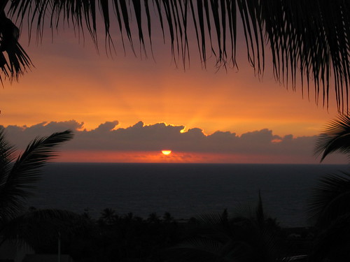
Beautiful sunset on the Kona coast
Photo Credit: flickr.com
The trade winds will be strengthening Wednesday…remaining active through the rest of this week into early next week. Looking at the latest weather map, we find a very strong 1042 millibar high pressure system in the area north-northwest of Hawaii…which will cause strengthening trade winds soon. These stronger winds will come in our direction from the northeast…which will keep somewhat cooler than normal weather in place. Once these blustery winds begin blowing, they will stick around through at least the next week.
The overlying atmosphere remains dry and stable, which will limit precipitation…to light amounts along the windward sides of the islands. There is quite a lot of high and middle level clouds out to the southwest and west of the island chain Tuesday evening. These are being carried our way on the jet stream level winds aloft. Here’s a looping satellite image of those cold brighter clouds at high altitudes of our atmosphere. At lower levels of the air mass, down where the trade winds blow, we’ll see just a few incoming showers, but nothing much for the time being.
~~~ The main thing Tuesday evening is the overcast clouds that are around, which kept sunshine to a bare minimum in most areas during the day. These clouds are up high, so that they don’t drop rain. There will be a few of the lower level clouds, being carried in our direction on the strengthening trade winds however. I got home late from my doctor’s appointment, which went fine by the way, but it pushed me back….so I’m late in getting this update out. Today was just one of those days, when I just couldn’t keep to my regular schedule. It’s chilly up here in Kula already, even with the high overcast clouds. The air temperature at around 7pm was 56F degrees already. It’s definitely warmer down near sea level, but even there, none of the observing stations got out of the 70’s during the day.
~~~ I need to go downstairs, down from my weather tower now, and get some dinner in me. It’s been a long day, and I will getting up early again on Wednesday morning. So, I’m going to sign off now, and go heat up the delicious vegetable soup that I made the other day. Pull out some tasty crackers, and put on some nice Brie cheese to eat with the soup. I hope you have a great Tuesday night, and that you will join me again Wednesday, as I’ll have your next new weather narrative from paradise waiting for you then. Aloha for now…Glenn.
Interesting: The Internet is no doubt changing modern society. It has profoundly altered how we gather information, consume news, carry out war, and create and foster social bonds. But is it altering our brains? A growing number of scientists think so, and studies are providing data to show it. What remains to be seen is whether the changes are good or bad, and whether the brain is, as one neuroscientist believes, undergoing unprecedented evolution.
Texting and instant messaging, social networking sites and the Internet in general can certainly be said to distract people from other tasks. But what researchers are worrying more about are the plastic brains of teens and young adults who are now growing up with all this, the "digital natives" as they’re being called.
"My fear is that these technologies are infantilizing the brain into the state of small children who are attracted by buzzing noises and bright lights, who have a small attention span and who live for the moment," said Baroness Greenfield, an Oxford University neuroscientist and director of the Royal Institution, in The Daily Mail today.
"I often wonder whether real conversation in real time may eventually give way to these sanitized and easier screen dialogues, in much the same way as killing, skinning and butchering an animal to eat has been replaced by the convenience of packages of meat on the supermarket shelf." Odd analogy, but one worth pondering.
Interesting2: Most fish have eyes on the sides of their heads, but a scientist now has confirmed a new and elusive species of carnivorous frogfish with eyes that face forward, like ours. The creature also has a fleshy chin and cheeks, adding to its strange appearance. The bizarre new species, Histiophryne psychedelica, made a brief splash a year ago when sport divers about 30 feet offshore of Ambon Island, Indonesia, photographed a shallow-water fish not seen before in 20 years of diving there.
Ichthyologist Ted Pietsch of the University of Washington’s Burke Museum of Natural History and Culture received pictures of the fish and guessed it belonged to the Histiophryne genus. Now he has confirmed this using genetic and morphological data, and fully described the freaky fish as a new species. "It is just an absolutely fantastic example of what natural selection can produce," Pietsch told LiveScience.
"And it’s a fantastic organism in its own right, and that is certainly enough to make it important." Pietsch’s description of the animal, partly supported by the National Science Foundation, is detailed in the journal Copeia. The fish is quite a sight: its extremely gelatinous skin is very fleshy, thick and loose; and the skin is covered with white stripes radiating from the eyes and continuing back to the body. This pigmentation could help the fish blend in among colorful, venomous corals on the sea floor in the area.
"The Psychedelic Frogfish probably joins the long list of dishonest and harmless animals that have evolved to mimic the beauty of venomous animals," said Leo Smith, assistant curator of fishes at The Field Museum in Chicago. "Pietsch and colleagues nailed this when they suggested that it looked just like the venomous corals found in its environment."
Interesting3: New Zealander Nadya Vessey, who lost her legs in a childhood illness, now swims like a mermaid – thanks to Oscar-winning movie special effects wizards Weta Workshop, according to news reports on Wednesday. The workshop, which won Oscars for their effects on The Lord of the Rings trilogy, made a mermaid wetsuit for her, complete with fishtail, which she tested in a Wellington pool.
Weta costume-maker Lee Williams said in an interview with Televison New Zealand that she wanted Vessey to be "beautiful and sexy" in the suit, which contains plastic moulds and has hand-painted fish-like scales. After seeing her swim with it, she said, "It was absolutely amazing. It’s beautiful to watch Vessey swim and to see that dream come true and to be a part of that. I feel quite blessed."
A thrilled Vessey said the idea stuck with her after telling a small boy who asked what had happened to her legs that she was a mermaid. "A prosthetic is a prosthetic, and your body has to be comfortable with it and you have to mentally make it part of yourself," she said.
Oscar-winning Weta Workshop director Richard Taylor said he agreed to Vessey’s request because it was a challenge. He said the tail had to be not only functional, but it was important it looked realistic. "What became apparent was that she actually physically wanted to look like a mermaid," he said.
Interesting4: Cairo Egyptian archeologists discovered a 4,000-year-old statue as they carried out routine cleaning work at one of the Giza pyramids on Tuesday. The 149-centimetre-long statue was found buried just 40 centimeters below the surface of the sand in the northern part of the King Men-Kau-Re’s pyramid (2551-2523 BC).
The statue is of an unidentified person wearing a medium-length wig, sitting on a chair with his right arm stretched on his knee and holding an unidentified object in his fist, Zahi Hawas, secretary general of the Egyptian Higher Council for Antiquities, said.
Hawas explained that it is difficult to recognize the dynasty to which the statue belongs because it has no inscriptions on it. However, Hawas said that from the way the statue was structured, it is most likely that it belongs to the fourth dynasty (2649-2513 BC.)
Interesting5: We all complain about commercials, and many people invest in technology to eliminate them. But a surprising new study in the Journal of Consumer Research shows that, contrary to popular belief, commercials improve television viewing in many cases. "Although consumers have difficulty predicting this, their enjoyment of television shows tends to gradually diminish during the viewing experience.
That is, viewers adapt to the show, making every minute slightly less enjoyable than the previous one," write authors Leif D. Nelson (University of California, San Diego), Tom Meyvis, and Jeff Galak (both New York University). The researchers conducted six studies where participants watched and evaluated either continuous or disrupted versions of programs.
In the first study, participants watched an episode of the sitcom "Taxi." Although the participants disliked the commercials, those who watched the show with commercials liked it better than those who watched it without. A second study found that people enjoyed a short animated clip more when it was interrupted by a commercial than when it played continuously.
A third study found that participants who watched an interrupted version of a nature documentary not only enjoyed the documentary more, but were also willing to donate more to a nature charity after viewing. The researchers also found that non-commercial interruptions had the same positive effect as commercials, reinforcing their hypothesis that when disrupted, people do not adapt to the programs and as a result, enjoy them more.
And, finally, commercial interruptions made a video clip more enjoyable for younger consumers than older consumers. "Very fast-paced and complex shows, such as "24," probably do not benefit from commercial interruptions since viewers are unlikely to adapt to these shows. However, we do find that commercial interruptions, although universally shunned, do make a wide variety of shows more enjoyable, including sitcoms, animations, documentaries, and music videos," the authors conclude.
Interesting6: Researchers have identified the gene that ultimately controls the production of tooth enamel, a significant advance that could some day lead to the repair of damaged enamel, a new concept in cavity prevention, and restoration or even the production of replacement teeth. The gene, called Ctip2, is a "transcription factor" that was already known to have several functions – in immune response, and the development of skin and the nervous system. Scientists can now add tooth development to that list.
The findings were just published in the Proceedings of the National Academy of Sciences. "It’s not unusual for a gene to have multiple functions, but before this we didn’t know what regulated the production of tooth enamel," said Chrissa Kioussi, an assistant professor in the College of Pharmacy at Oregon State University. "This is the first transcription factor ever found to control the formation and maturation of ameloblasts, which are the cells that secrete enamel."
The researchers used a laboratory mouse model in this study in which this gene has been "knocked out" and its protein is missing. Such mice lack basic biological systems and cannot live after birth, but allow scientists to study what is there, and what’s missing. In this case, the mice had rudimentary teeth ready to erupt, but they lacked a proper enamel coating, and never would have been functional. "Enamel is one of the hardest coatings found in nature, it evolved to give carnivores the tough and long-lasting teeth they needed to survive," Kioussi said.
Interesting7: Our ability to conserve and protect wildlife is at risk because we are unable to accurately gauge how our environment is changing over time, says new research in Conservation Letters. The study shows that people may not realize species are declining all around them, or that their local environment may have changed dramatically since their parents’ and grandparents’ days, and even in their own lifetime.
This could be bad news for conservation projects, because if people do not perceive there to be any degradation of the world around them, they may be less willing to engage in activities to conserve and protect the environment. The new study provides the first evidence of so-called ‘shifting baseline syndrome’ – a conservation theory which says that people’s perception of the environment is determined by what they see now, with their own eyes, and does not take into account what things were like in the past.
Interesting8: Jagged mountains the size of the Alps have been found entombed in Antarctica’s ice, giving new clues about the vast ice sheet that will raise world sea levels if even a fraction of it melts, scientists said on Tuesday. Using radar and gravity sensors, the experts made the first detailed maps of the Gamburtsev subglacial mountains, originally detected by Russian scientists 50 years ago at the heart of the East Antarctic ice sheet.
"The surprising thing was that not only is this mountain range the size of the Alps, but it looks quite similar to the (European) Alps, with high peaks and valleys," said Fausto Ferraccioli, a geophysicist at the British Antarctic Survey who took part in the research.
He told Reuters that the mountains would probably have been ground down almost flat if the ice sheet had formed slowly. But the presence of jagged peaks might mean the ice formed quickly, burying a landscape under up to 2.5 miles of ice.
Ferraccioli said the maps were "the first page of a new book" of understanding how ice sheets behave, which in turn could help predict how the ice will react to global warming. Antarctica, bigger than the United States, has been swathed in ice for about 35 million years, and contains enough of it to raise world sea levels by about 187 feet if it ever all melted.
So even a fractional melt would affect coasts around the globe. "Unless we have a basic understanding of how ice sheets work, any sort of predictive model won’t match reality," Ferraccioli said. The U.N. panel on climate change says that greenhouse gases, mainly emitted by burning fossil fuels, will bring more heat waves, floods and droughts, and raise sea levels.
The team of experts from Australia, Britain, Canada, China, Germany, Japan and the United States also found water below the ice, using survey aircraft that flew 75,000 miles. "The temperatures at our camps hovered around minus 22 Fahrenheit, but beneath us at the bottom of the ice sheet we saw liquid water in the valleys," Robin Bell, of the Lamont-Doherty Earth Observatory at Columbia University, said in a statement. Many sub-glacial lakes have been found in Antarctica in recent years.
Interesting9: Chinese dairy products, flour, meat and other foods remain dangerously tainted with illegal additives despite a crackdown, the country’s health ministry said on Tuesday. Vice Minister of Health, Chen Xiaohong, told a video conference for officials some food and liquor makers continued to use banned additives, and high-tech lawbreakers were "challenging the oversight and administration capacities of law enforcement agencies", the Xinhua news agency reported.
"Some food businesses still lack a grasp of the harmfulness and severity of illegal additives," Chen said. "Their commitment to correcting this is not high." China’s problems with tainted foods and medicines came under international spotlight from 2007 through a string of scares over toxins in exports. Public worries came to a head last year, when the Sanlu Group and other dairy companies were found to be using raw milk adulterated with the industrial chemical, melamine.
At last 6 children in China died from drinking melamine-tainted infant formula, and nearly 300,000 fell ill. The government has investigated and dealt with 1,274 cases of illegal and reckless use of food additives since late 2008, Xinhua also reported. Seven people suspected of related crimes have been handed to police, and four of them have been formally arrested, the report said. Chen, the health official, said the crackdown so far was not enough and some firms had not mended their ways. "The illegal use of additives over a long time in some sectors has still not been effectively halted," he said.
Posted by Glenn
[4] Comments
February 23-24, 2009
Air Temperatures – The following maximum temperatures were recorded across the state of Hawaii Monday afternoon:
Lihue, Kauai – 73
Honolulu, Oahu – 79
Kaneohe, Oahu – 75
Kahului, Maui – 77
Hilo, Hawaii – 76
Kailua-kona – 80
Air Temperatures ranged between these warmest and coolest spots near sea level, and on the highest mountains…at 5 p.m. Monday evening:
Kailua-kona – 77F
Lihue, Kauai – 68
Haleakala Crater – 48 (near 10,000 feet on Maui)
Mauna Kea summit – 32 (near 14,000 feet on the Big Island)
Precipitation Totals – The following numbers represent the largest precipitation totals (inches) during the last 24 hours on each of the major islands, as of Monday afternoon:
0.15 Lihue, Kauai
0.10 Kahuku Training Area, Oahu
0.00 Molokai
0.00 Lanai
0.00 Kahoolawe
0.03 Puu Kukui, Maui
0.02 Glenwood, Big Island
Weather Chart – Here’s the latest (automatically updated) weather map showing a strong 1038 millibar high pressure system located far to the north-northwest of the islands. This high pressure system will keep moderately strong trade winds blowing Tuesday…strengthening into Wednesday.
Satellite and Radar Images: To view the cloud conditions we have here in Hawaii, please use the following satellite links, starting off with the Infrared Satellite Image of the islands to see all the clouds around the state during the day and night. This next image is one that gives close images of the islands only during the daytime hours, and is referred to as a Close-up visible image. This next image shows a larger view of the Pacific…giving perspective to the wider ranging cloud patterns in the Pacific Ocean. Finally, here’s a looping IR satellite image, making viewable the clouds around the islands 24 hours a day. To help you keep track of where any showers may be around the islands, here’s the latest animated radar image.
Hawaii’s Mountains – Here’s a link to the live webcam on the summit of near 14,000 foot Mauna Kea on the Big Island of Hawaii. The tallest peak on the island of Maui is the Haleakala Crater, which is near 10,000 feet in elevation. These two webcams are available during the daylight hours here in the islands…and when there’s a big moon rising just after sunset for an hour or two! Plus, during the nights and early mornings you will be able to see stars, and the sunrise too…depending upon weather conditions.
Aloha Paragraphs

Helicopter view…remote Kauai beaches
Photo Credit: flickr.com
Our local trade winds were on the light side Monday, although will be increasing in strength through the rest of this week, from the northeast direction. As we get into Tuesday afternoon and Wednesday, we’ll find a very strong high pressure system moving into the area north of Hawaii…causing blustery winds over the following days. These stronger winds will come in our direction from the northeast…which will keep somewhat cooler than normal weather in place for several days thereafter. Once these blustery northeast winds begin blowing, they will stick around into at least the early part of next week.
The overlying atmosphere remains dry and stable, which will limit precipitation…to light amounts along the windward sides of the islands. There is a big bunch of high and middle level clouds out to the southwest and west of the island chain Monday evening. These will be carried our way at times, which will filter and dim our sunshine to some degree. Here’s a looping satellite image of those brighter clouds. The atmosphere will become a bit more moist as we move into Tuesday onward, so that there will be an increase in windward showers at times.
It’s Monday evening here in Kihei, Maui, as I begin this last paragraph of today’s weather narrative. As you read above, we’ll find the trade winds a major part of our Hawaiian Island weather picture well into the future. These trade winds will shift back to the northeast direction by mid-week, and strengthen in the process. As you probably know, winds coming in from this more northerly point on the compass, often bring slightly cooler than normal air temperatures to the islands. This won’t be a full blown cold snap, but we will continue to feel somewhat cooler than normal through the rest of this week.
~~~ If you had a chance to click on that looping satellite image above, you will have seen all that high cirrus clouds, mixed with middle level altocumulus and altostratus clouds too. Looking out the window here in Kihei, before I make the drive upcountry to Kula, I see the thickening high clouds to our southwest, which appear to be taking aim on our area. These clouds, besides beautifying our local skies, will dim and filter our sunshine at times too. These clouds, if they continue to stream in our direction, may act like a blanket, at leat a little, and hold some of Monday’s daytime heat from escaping out to space tonight. Therefore, we might be a tad warmer tonight, than we have been the last several early mornings. It’s 8pm at the moment, Monday evening, and I’m up in my weather tower, getting ready to go to bed and read for a while. The temperature is already very chilly, reading 53.2 degrees. It’s going to go down well into the 40F’s tonight, so perhaps we can forget that call for a tad bit warmer tonight! It’s already 64 degrees at the same time down in Kahului, which will dive into the 50’s tonight as well. So, get out that extra blanket out, or keep the one you used last night on the bed!
~~~ The big news in our local weather will be the strengthening northeast winds. These won’t be just a couple of days worth of winds either, but more like a week’s worth at least. They won’t be the kind of winds, at least in most places around the state, that are too strong. They will however be strong enough, that we should see NWS issued small craft wind advisory flags going up pretty much throughout the entire state’s coastal and channel waters. The NE orientation of these winds will have them rushing through valley’s, especially here on Maui, where the central valley will be dusty…and have lots of fast paced winds shooting out through the Maalaea Bay down towards Kihei.
~~~ I’ll look forward to joining you here again early Tuesday morning, when I’ll have your next new narrative from paradise…waiting for you then. I’m heading home now, and will meet my neighbors for a nice evening walk around the neighborhood. I always look forward to changing clothes, and putting my walking shoes on as soon as I get home. I hope you have a great Monday night from wherever you happen to be reading from! Aloha for now…Glenn.
Interesting: Canada’s inland waters, the countless lakes and reservoirs across the country, are important "sentinels" for climate change and Ottawa and the provinces are ignoring the warnings. That’s the message from University of Alberta biologist David Schindler and colleagues in a paper in the journal, Science. Schindler is a co-author of Sentinels of Change, which reviewed papers addressing the effects of climate change revealed in numerous long-term studies presented at a conference last September.
In his paper, Schindler highlighted studies that have shown that Canada and the United States will have to rethink plans to use the Laurentian Great Lakes as an emergency water supply if a dramatic shortage befalls North America in the future. Data collected by researchers indicate the water balance is the Laurentian Great Lakes is precarious because it is only renewing itself at the rate of less than one per cent a year. Schindler and his co-authors also analyze a study involving carbon emissions.
"Recent studies show that lakes release very high releases of greenhouse gases to the atmosphere, in many cases higher than the surrounding forests in the same watersheds. This has been missed in climate modeling to date." Schindler says more inland water studies are needed in Canada because they provide valuable data on water levels, carbon cycles, acid rain and the frequency of forest fires. There are three long-term inland water studies in Canada, all of them in Ontario. Schindler is calling for more funding and expansion of the research program.
Interesting2: Representatives from more than 140 countries today committed to reduce global mercury pollution, which will help protect the world’s citizens from the dangerous neurotoxin. This agreement was propelled by the United States’ reversal in policy, which also influenced policy reversals of other countries, including China and India. The announcement is a historic step forward in the fight against mercury pollution, according to scientists and policy experts at the Natural Resources Defense Council (NRDC).
"This is great news for reducing mercury pollution around the world, and shows a commitment from the Obama Administration to international environmental issues," said Susan Egan Keane, policy analyst for NRDC. "The United States has taken a leadership role that will chart a new course on mercury protections around the world. We have set a strong example that is already influencing others to do the same."
The committed countries will reduce risks to human health and the environment from mercury by coordinating global cuts in the use and release of mercury into our air, water and land. The United Nations Environment Program Governing Council, which is meeting this week in Nairobi, Kenya, will now develop a legally binding treaty to be enacted by 2013.
The treaty will include actions to reduce global mercury pollution and human exposure to the chemical, by reducing intentional use of mercury in industrial processes and products and reducing emissions from coal plants and smelters. It will also address the problems posed by mercury waste sites.
Interesting3: A new international study has warned that millions of people dependent on fisheries in Africa, Asia and South America could face unprecedented hardship as a consequence of climate change. Researchers examined the fisheries of 132 nations to determine which were the most vulnerable, based on the potential environmental impact of climate change, how dependent their economy and diet were on fisheries, and the capacity of the country to adapt.
Climate change can affect the temperature of inland lakes, the health of reefs and how nutrients circulate in the oceans, the researchers say. They identified 33 countries as "highly vulnerable" to the effects of global warming on fisheries. These countries produce 20 per cent of the world’s fish exports and 22 are already classified by the UN as "least developed". Inhabitants of vulnerable countries are also more dependent on fish for protein — 27 per cent of dietary protein is gained from fish, compared with 13 per cent in other countries.
Two-thirds of the most vulnerable nations identified are in tropical Africa. The study, led by the Malaysia-based WorldFish Center, was published in Fish and Fisheries this month. Using an approach developed from the International Panel on Climate Change’s methods for assessing the vulnerability of nations to climate change as a whole, the authors determined that both coastal and landlocked African countries such as Guinea, Malawi, Senegal and Uganda; Asian countries including Bangladesh, Cambodia, Pakistan, and Yemen; and Colombia and Peru in South America, are among the most vulnerable.
The 33 countries should be a priority for climate change adaptation efforts and, more importantly, their fisheries should be maintained or enhanced to ensure they can make contributions to poverty reduction, say the authors. Edward Allison, director of policy, economic and social science at WorldFish Center and the paper’s lead author, says that to ensure fisheries continue to support the poorest people policies should be implemented on two fronts: mitigation and adaptation.
But while mitigation can be valuable — because of relationships between emission reductions, energy saving and responsible fisheries — "the challenge of adaptation is both significant and potentially urgent", he says. "Policy support for adaptation involves supporting measures to reduce exposure of fishing people to climate-related risks, reducing dependence of peoples’ livelihoods on climate-sensitive resources, and supporting people’s capacity to anticipate and cope with climate-related changes", he concludes.
Interesting4: During the past 14 years, a tiny insect no bigger than a grain of rice has laid waste a swathe of British Columbia’s forests so vast that the rust-red wasteland is visible from space. The mountain pine beetle has infested and killed over half the lodge pole pine forest in the centre of the province—an area larger than England. It has rampaged eastwards into northern Alberta for the first time. (It has also made localized attacks on forests in all 11 western American states.)
Scientists now fear the voracious beetle is about to invade the jack pines of the boreal forest, which could see the plague sweep across northern Canada to the Atlantic coast. It is an unprecedented infestation that could become a catastrophe. The pine beetle is a well-known pest, not an exotic import, but no effective means has been found to stop it.
The beetles swarm up trees in large numbers, killing them by boring through the bark, sapping their nutrients and emitting a damaging blue fungus. Cold winters and forest fires normally keep the beetle populations in check. Some forest scientists trace the current outbreak to 1994, when provincial-government foresters, fearing the ire of greens, failed to eradicate a small infestation in a provincial park by cutting and burning.
In any event, recent British Columbian winters have not been cold enough to kill the beetles. The infestation is gathering pace: foresters fear that by 2013 four-fifths of British Columbia’s central-southern pine forest will be gone. Wafted eastwards by strong winds, in 2002 the beastie made its debut in northern Alberta and further south in the national parks of Jasper, Banff and Kananaskis on the eastern slopes of the Rocky Mountains. It has advanced 250 miles across the province to Slave Lake. The beetle is now established in Alberta, despite vigorous cutting and burning.
Interesting5: Nine out of 10 marine species found off Australia’s south-west coast are found nowhere else on earth but less than one per cent of this globally significant region is protected. A new report found a series of globally significant “hotspots” for marine life in the region, home to a far greater proportion of unique marine life than the Great Barrier Reef, and recommends the creation of large sanctuaries to secure its future. Protecting Western Australia’s big blue backyard was prepared by the Australian Conservation Foundation for a new collaboration of key Australian and international conservation groups formed to secure the future of Australia’s south-west marine environment.
WWF-Australia is a key member of “Save our Marine Life”, which also includes the Conservation Council of Western Australia, the Australian Conservation Foundation, the Wilderness Society, the Australian Marine Conservation Society , the Nature Conservancy and the Pew Environment Group. The report highlighted Perth Canyon, one of only two known sites in Australian waters where the endangered blue whale comes to feed, and the Diamantina Fracture Zone, Australia’s largest mountain range submerged in its deepest stretch of water at 7,400 metres and thought to host unique species not yet known to science.
The report also identified the importance of creating large marine sanctuaries to Western Australia’s tourism and whale watching industry. At the launch in Perth today Professor Jessica Meeuwig of the Centre for Marine Futures at the University of Western Australia said: “Many economically important marine species, such as rock lobster, dhufish and baldchin groper are under threat. “Large marine sanctuaries are critical to maintaining the health of the marine environment, helping fish stocks recover and securing the future of commercial and recreational fishing in the region.”
Interesting6: Indochina’s few surviving elephants are under increasing threat from booming illegal ivory prices in Viet Nam, according to a new market analysis released by TRAFFIC, the wildlife trade monitoring network. An assessment of the illegal ivory trade in Viet Nam said Vietnamese illegal ivory prices could be the highest in the world, with reports of tusks selling for up to USD1500/kg and small, cut pieces selling for up to USD1863/kg. Most of the raw ivory was said to originate from the Lao Peoples’ Democratic Republic, with small amounts from Viet Nam and Cambodia.
“This is a worrying trend that indicates even more pressure is being put on already fragile Asian Elephant populations,” said Azrina Abdullah. Director of TRAFFIC Southeast Asia. According to IUCN figures, no more than 1,000 elephants are believed to survive in Lao PDR, while in Viet Nam, fewer than 150 are believed to exist. In December 2008, TRAFFIC released a report that found evidence of widespread smuggling of live Asian Elephants and their ivory from Myanmar.
Mammoth ivory from Russia was also used in small quantities, but no African raw ivory was found, although it was still being illegally imported into Viet Nam up to at least 2004. Trade in ivory was outlawed in Viet Nam in 1992, but a major loophole in the legislation exists because shops can still sell ivory in stock dating from the prohibition. This allows some shop owners to restock illegally with recently-made carved ivory.
Interesting7: The most detailed map of the Moon ever created has revealed never-before-seen craters at the lunar poles. The map is also revealing secrets about the Moon’s interior — and hinting about Mars’s interior as well. C.K. Shum, professor of earth sciences at Ohio State University, is part of the international research team that published the map in the February 13 issue of the journal Science.
"The surface can tell us a lot about what’s happening inside the Moon, but until now mapping has been very limited," Shum said. "For instance, with this new high-resolution map, we can confirm that there is very little water on the Moon today, even deep in the interior. And we can use that information to think about water on other planets, including Mars."
Using the laser altimeter (LALT) instrument on board the Japanese Selenological and Engineering Explorer (SELENE) satellite, the researchers mapped the Moon at an unprecedented 9-mile resolution. The principal investigator of the LALT instrument is Hiroshi Araki of the National Astronomical Observatory of Japan, and he is the lead author of the study. Shum is a member of the LALT science team.
The map is the first to cover the Moon from pole to pole, with detailed measures of surface topography, on the dark side of the moon as well as the near side. The highest point — on the rim of the Dririchlet-Jackson basin near the equator — rises more than 6.5 miles high, while the lowest point — the bottom of Antoniadi crater near the south pole — rests more than 5.5 miles deep. In part, the new map will serve as a guide for future lunar rovers, which will scour the surface for geological resources.
But Araki and his colleagues did something more with the map: they measured the roughness of the lunar surface, and used that information to calculate the stiffness of the crust. If water flowed beneath the lunar surface, the crust would be somewhat flexible, but it wasn’t. The surface was too rigid to allow for any liquid water, even deep within the Moon.
Interesting8: Earth and the other planets of the solar system are under constant bombardment from particles that range in size from a sand grain to a boulder and are collectively known as meteoroids. Many meteoroids are the detritus left over from collisions of asteroids and comets and impacts to other planets. If a meteoroid enters Earth’s atmosphere, it starts to burn up, forming a bright streak in the sky, called a meteor.
Meteors can come from asteroid or comet fragments. If that meteor is brighter than any of the planets in the sky, it is deemed a fireball (also called a bolide). A blazing bolide can also create a sonic boom that can be heard up to 30 miles away — these explosive noises were heard over Kentucky on Friday, Feb. 13, and over Texas on Sunday, Feb. 15, causing a number of startled citizens to call local law enforcement.
Initial speculation that these streaks of light and accompanying boom were caused by debris from the Feb. 10 collision of two satellites was later refuted by astronomers, who said it was likely a meteor. Preston Starr, the observatory manager at the University of North Texas, told the Associated Press that the object would have been about the size of a truck and that somewhere between eight and 10 such objects burn up in the atmosphere every year.
Interesting9: A fresh new face has moved into our neighborhood, but once this green-colored comet swings by Earth tonight, it may never come again. Comet Lulin is currently sailing through the inner solar system and is getting closer to our home planet, with its nearest approach expected on February 24.
Although it’s hard to glimpse with the naked eye, the comet "should be a fairly easy object [to see using] modest amateur telescopes or even binoculars," said Don Yeomans, a comet expert at NASA’s Jet Propulsion Laboratory in Pasadena, California. Astronomer Mark Hammergren of Chicago’s Adler Planetarium added that the icy body has the potential to do something unexpected.
Comet Lulin is arriving from the far reaches of the solar system on a nearly parabolic orbit—"it’s almost as if it comes from infinity and goes back out to infinity," he said. This means Lulin could be on its first pass by the sun, so the comet should still be encrusted in "fresh" ices preserved by the freezing environment of the outer solar system, Hammergren said.
As Lulin is exposed to the sun’s heat for the first time, those ices are vaporizing—activity that could cause the comet to brighten rapidly or even break apart. Even now the comet is spewing cyanogen and diatomic carbon, both gases that glow green in sunlight out in the vacuum of space.
What’s more, the comet’s orbit is in nearly the same plane as Earth’s, but the comet is traveling in the opposite direction. This causes Lulin to appear to move unusually fast and display a rare anti-tail—an optical effect that creates a secondary "tail" pointing toward the sun.
Interesting10: NASA scientists reported today that the global average surface temperature in 2008 was the coldest since 2000, but was still well above the long-term average, coming in at ninth-warmest since measurements began in 1880. This followed another report from the National Climatic Data Center that said 2008 was the eighth-warmest year on record. The two organizations analyze data sets slightly differently, which explains the disparity.
Most of the Earth was either near normal or warmer than average, with Eurasia, the Arctic and the Antarctic Peninsula being exceptionally warm (see map, above). Much of the Pacific Ocean was cooler than the long-term average due to a strong La Nina, a natural cooling of the ocean water in that region. El Nino is the opposite phase, when water is warmer-than-average.
The north-central USA was one of the few locations on the Earth’s land area that was cooler-than-average. "Given our expectation that the next El Nino will begin this year or in 2010, it still seems likely that a new global surface air temperature record will be set within the next one to two years, despite the moderate cooling effect of reduced solar irradiance," said James Hansen, director of GISS.
The sun is just passing through solar minimum, the low point in its 10- to 12-year cycle of electromagnetic activity, when it transmits its lowest amount of radiant energy toward Earth.
Posted by Glenn
No Comments
February 22-23, 2009
Air Temperatures – The following maximum temperatures were recorded across the state of Hawaii Sunday afternoon:
Lihue, Kauai – 73
Honolulu, Oahu – 79
Kaneohe, Oahu – 75
Kahului, Maui – 80
Hilo, Hawaii – 74
Kailua-kona – 82
Air Temperatures ranged between these warmest and coolest spots near sea level, and on the highest mountains…at 5 p.m. Sunday evening:
Kailua-kona – 81F
Hilo, Hawaii – 70
Haleakala Crater – 50 (near 10,000 feet on Maui)
Mauna Kea summit – 36 (near 14,000 feet on the Big Island)
Precipitation Totals – The following numbers represent the largest precipitation totals (inches) during the last 24 hours on each of the major islands, as of Sunday afternoon:
0.12 Mount Waialaele, Kauai
0.15 Oahu Forest NWR, Oahu
0.22 Molokai
0.00 Lanai
0.00 Kahoolawe
0.15 Hana airport, Maui
0.19 Glenwood, Big Island
Weather Chart – Here’s the latest (automatically updated) weather map showing high pressure systems located far to the northwest and north of the islands, with a large low pressure system located far to the NE, which will cause trade winds both Monday and Tuesday…generally light to locally moderate.
Satellite and Radar Images: To view the cloud conditions we have here in Hawaii, please use the following satellite links, starting off with the Infrared Satellite Image of the islands to see all the clouds around the state during the day and night. This next image is one that gives close images of the islands only during the daytime hours, and is referred to as a Close-up visible image. This next image shows a larger view of the Pacific…giving perspective to the wider ranging cloud patterns in the Pacific Ocean. Finally, here’s a looping IR satellite image, making viewable the clouds around the islands 24 hours a day. To help you keep track of where any showers may be around the islands, here’s the latest animated radar image.
Hawaii’s Mountains – Here’s a link to the live webcam on the summit of near 14,000 foot Mauna Kea on the Big Island of Hawaii. The tallest peak on the island of Maui is the Haleakala Crater, which is near 10,000 feet in elevation. These two webcams are available during the daylight hours here in the islands…and when there’s a big moon rising just after sunset for an hour or two! Plus, during the nights and early mornings you will be able to see stars, and the sunrise too…depending upon weather conditions.
Aloha Paragraphs

A nice reflection
Photo Credit: flickr.com
Our local winds continue to show a northeast tendency in direction, keeping somewhat cool air over the islands. These NE breezes won’t be all that blustery at least, blowing in the light to moderately strong range over the next few days. Looking further ahead into the new week, we’ll find a very strong high pressure system moving into the area north of Hawaii by mid-week…triggering blustery winds over the following days. These stronger winds may come at us from a northeast direction as well…which will keep cooler than normal weather in place through the end of the week.
The long lasting high clouds went away later Saturday, but another new area of those cirrus clouds are passing across our skies locally Sunday. Meanwhile, the clouds being carried our way on the northeast wind flow, will bring low cloudiness over the windward sides at times. There won’t be many showers falling though, as the overlying atmosphere remains very dry and stable. Here’s a looping satellite image of those new high clouds moving in our direction from the west or southwest. They will filter and dim our sunshine at times.
It’s Sunday evening here in Kula, Maui, as I begin this last paragraph of this weather narrative. I’m going to leave this morning’s entry, just so that you will know what to expect again Sunday night into Monday morning. Wow, it’s so cold up here at this 3,100 foot elevation this morning! It’s the most chilly morning of the winter thus far, with my outdoor temperature sensor reading 41.2F degrees. It’s not just up here either, even Kahului, down at sea level, was showing a very chilly 54 degrees this morning as well. Kahului is famous for having the coldest minimum sea level temperature on record, which was a very cold 48 degrees! The morning low at Kahului this morning was 54 degrees, which missed the record low of 53 degrees…which was set back in 1972.
~~~ I had a simply wonderful day, relating with my neighbors! I took my breakfast over to their deck, and ate it, as they have warming morning sunshine. I washed my car, which was way over due to do, so I’ll start out my work week with a clean car to drive. Later in the day we all took a very long walk, compared at least to the shorter walks we often take here in the neighborhood. We took one of the uphill roads that wonder way up the mountain. There are houses up there, which were very inspiring, and remind me of what I might be looking for one of these days. There was one particular rose bush that had flowers that rated way up there on the fragrance scale of wonderful scents!
~~~ It’s just before sunset now, and I want to get out on my weather deck, and watch to see if the high cirrus clouds will light up nicely, as the sun sinks into the ocean west of here. I am so lucky to have a bi-coastal view from my house, so that the sunsets can be spectacular at times. I hope you are enjoying yourself, wherever you happen to be reading from! I’ll be up very early Monday morning, and after meditating for half an hour, will come back online, to prepare your next new weather narrative from paradise. Aloha for now…Glenn.
Interesting: On Sunday, nominated movie stars will show up at Hollywood’s Kodak Theatre hoping to walk away clutching one of those glowing statuettes. But there’s more to that golden guy than meets the eye. When they pick up their trophies, the winning celebs are toting around 8.5 pounds of metal. Oscar is 13.5 inches (34 centimeters) tall. The Oscar statuettes, officially dubbed the Academy Award of Merit, have a 24-karat gold plating on their surface. Beneath the gold, the statuette’s interior is a metal mixture called Britannium, also called Britannia metal. It is an alloy of tin (93 percent), antimony (5 percent), and copper (2 percent).
It’s known for its smooth texture and silvery appearance. Though this mixture of metals has been the standard for the shiny trophies for several decades, it hasn’t always been the composition of choice. The statuettes presented at the first Academy awards ceremonies, a private dinner on May 16, 1929, at the Hollywood Roosevelt Hotel, were gold-plated solid bronze. During World War II, when metals and other materials were scarce, the Oscars were made of plaster. After the war, the plaster statues were then turned in for the normal gold-plated versions, according to the U. S. Geological Survey. Since the first Academy awards banquet, 2,701 statuettes have been presented. New statuettes are cast each January, then molded, polished and buffed by workers at R.S. Owens & Company, which has made the awards since 1982.
Interesting2: Some outdoor naturescapes are enjoying a little extra sparkle – with assistance from old beer bottles and other recyclables. Bits of repurposed glass, in jewel-like nuggets, provide a decorative accent at the base of hedges, potted greens and other types of landscaping. The product, formed by grinding various types of recycled glass, is sold at some landscape shops around the nation, and also via online retailers. In Austin, Texas, the solid waste department gives the stuff away for free. Depending on the supplier, the glass pebbles are available in an assortment of hues. Also, the product, sometimes referred to as "glass mulch," is tumbled to round out sharp edges.
ASG Glass in Utah produces landscape glass in a wide variety of individual colors and blends. Some are the natural color of the bottle or window being recycled, others feature added pigment, according to ASG Glass president Berkeley Booth. The array of colors allows gardeners flexibility for customized designs. A football team ordered a truckload of green and white glass, which probably will be used as a team logo, Booth said. He also noted that often, blue hues (such as the Caribbean mix, featuring soft sea tones and clear pieces) are used to form a faux stream or pond that winds along a portion of the landscape.
At a flower show, someone created a diamond design with pink glass, and an art center in Arizona created a striking look for cactus planters by lining each one with a different color of glass. The price for the ASG Glass products depends on the color and quantity. The 25-pound bags, for example, are between $20 and $108. Usually, about seven pounds of glass is needed per square foot. Online supplier is EnvrioGLAS, in Plano, Texas touts another environmental benefit of the recycled product.
"Glass mulch does not absorb water like wood mulch, so the water goes where it is intended – into the plants – and even less water is used." Most of its products are sold in 50-pound bags for around $35. Charlie Nardozzi, senior horticulturist for the National Garden Association in Vermont, said he regards the product as primarily a decorative feature. Unlike organic mulch, glass doesn’t break down and fertilize the soil. He said he’s not sure if it offers other mulch functions, such as keeping the soil cool and moist. It does, however, offer an interesting aesthetic value.
Interesting3: About half of the oil in the ocean bubbles up naturally from the seafloor, with Earth giving it up freely like it was of no value. Likewise, NASA satellites collect thousands of images and 1.5 terrabytes of data every year, but some of it gets passed over because no one thinks there is a use for it. Scientists recently found black gold bubbling up from an otherwise undistinguished mass of ocean imagery. Chuanmin Hu, an optical oceanographer at the University of South Florida, St. Petersburg, and colleagues from the National Oceanic and Atmospheric Administration (NOAA) and the University of Massachusetts–Dartmouth (UMass), found that they could detect oil seeping naturally from the seafloor of the Gulf of Mexico by examining streaks amid the reflected sunlight on the ocean’s surface.
Most researchers usually discard such "sun glint" data as if they were over-exposed photos from a camera. "Significant sun glint is sometimes thought of as trash, particularly when you are looking for biomass and chlorophyll," said Hu. "But in this case, we found treasure." The new technique could provide a more timely and cost-effective means to survey the ocean for oil seeps, to monitor oil slicks, and to differentiate human-induced spills from seeps. Oil decreases the roughness of the ocean surface. Depending on the angles of the camera and of the light reflection, oil creates contrasting swaths that can show up in airborne images as either lighter or darker than the surrounding waters.
Interesting4: While the nation as a whole gained freshwater wetlands from 1998 to 2004, a new report by NOAA and the U.S. Fish and Wildlife Service documents a continuing loss of coastal wetlands in the eastern United States. The new report, Status and Trends of Wetlands in the Coastal Watersheds of the Eastern United States, shows a loss of 59,000 acres each year in the coastal watersheds of the Great Lakes, Atlantic Ocean and Gulf of Mexico from 1998 to 2004. “This report shows the nation’s need to expand the effort to conserve and rebuild valuable coastal wetlands,” said Jim Balsiger, acting NOAA assistant administrator for NOAA’s Fisheries Service. “Coastal wetlands are nurseries for important commercial and recreational fish and are vital to many threatened and endangered species.
They also provide natural protection to coastal communities from the most damaging effects of hurricanes and storm surges.” One reason wetland loss is concentrated in coastal watersheds is that with large numbers of people living here – more than half of the nation’s population lives in coastal counties in densities five times greater than inland counties – the building of roads, homes and businesses have accelerated wetlands loss, particularly along the Gulf of Mexico. Wetland restoration is also more difficult in coastal areas where land values are high and factors such as storms and large expanses of soft muddy ground hamper restoration efforts.
Interesting5: Space scientists from the University of Leicester are keeping a close eye on a ‘green comet’ fast approaching the Earth – reaching its nearest point to us on February 24. Comet Lulin will streak by the earth within 38 million miles – 160 times farther than the moon -and is expected to be visible to the naked eye. Discovered only a year ago, the comet gains its green colour from poisonous cyanogen and diatomic carbon gases in its atmosphere. This will be the comet’s first visit to the Earth’s inner solar system- and will enable the team from the University of Leicester to gain valuable insights into the comet.
They are using NASA’s Swift satellite to monitor Comet Lulin as it closes on Earth. The spacecraft has recorded simultaneous ultraviolet and X-ray images of a comet. “Swift is the ideal spacecraft with which to observe this comet”, said Jenny Carter, a scientist working with Dr Andrew Read at the University of Leicester, UK. “We alerted the Swift team that the comet might be visible” said Dr Read “and they quickly responded to take images using both the X-ray (XRT) and Ultraviolet/Optical Telescopes (UVOT) on-board.”
Dr Julian Osborne, leader of the Swift project at Leicester, said ‘The wonderful ease of scheduling of Swift and its joint UV and X-ray capability make Swift the observatory of choice for observations like these.’ Carter added: “It is important to carry out these observations as they give us clues about the origin of comets and the solar system". As the University of Leicester has played a major role in developing Swift’s X-Ray Telescope and is an important centre for the study of high-energy emission from objects within our Solar System, it is an ideal place for this study to be carried out.
A comet is a clump of frozen gases mixed with dust. These "dirty snowballs" cast off gas and dust whenever they venture near the sun. Comet Lulin, which is formally known as C/2007 N3, was discovered last year by astronomers at Taiwan’s Lulin Observatory.
Interesting6: Think of it as a galactic garbage dump. With a recent satellite collision still fresh on minds, participants at a meeting in the Austrian capital this week are discussing ways to deal with space debris — junk that is clogging up the Earth’s orbit. Some suggest a cosmic cleanup is the way to go. Others say time, energy and funds are better spent on minimizing the likelihood of future crashes by improving information sharing. The informal discussions on the sidelines of a meeting of the United Nations Committee on the Peaceful Uses of Outer Space arose from concern about the Feb. 10 collision of a derelict Russian spacecraft and a working U.S. Iridium commercial satellite.
The incident, which is still under investigation, generated space junk that could circle the Earth and threaten other satellites for the next 10,000 years; it added to the already worrying amount of debris surrounding the planet. Nicholas L. Johnson, NASA’s chief scientist for orbital debris, said about 19,000 objects are present in Earth’s low and high orbit — including about 900 satellites, but much of it is just plain junk. He estimated that included in the 19,000 count are about a thousand objects larger than 4 inches that were created by last week’s satellite collision, in addition to many smaller ones. He predicted that if more junk accumulates, the likelihood of similar collisions — currently very rare — will increase by 2050.
To Johnson, the "true solution" in the long run is to go get the junk — or push it away to a higher altitude before it has time to crash into anything. "Today’s environment is all right but the environment is going to get worse, therefore I need to start thinking about the future and how can I clean up sometime in the future," he said. Johnson is the co-lead of an International Academy of Astronautics study that is exploring ways of extracting space debris from the Earth’s orbit. Some of the suggestions sound pretty spaced out.
One proposes attaching balloons to pieces of debris to increase their atmospheric drag and bring them back to Earth faster. Another, said Johnson, foresees attaching a 10-mile (16-kilometer) electrodynamic tether to debris that would generate a current, which then could be controlled from the ground enabling technicians to bring it down. Many scientists are skeptical about the possibility of a cleanup.
Posted by Glenn
[2] Comments
February 21-22, 2009
Air Temperatures – The following maximum temperatures were recorded across the state of Hawaii Saturday afternoon:
Lihue, Kauai – 74
Honolulu, Oahu – 79
Kaneohe, Oahu – 76
Kahului, Maui – 75
Hilo, Hawaii – 74
Kailua-kona – 80
Air Temperatures ranged between these warmest and coolest spots near sea level, and on the highest mountains…at 5 p.m. Saturday evening:
Kailua-kona – 78F
Lihue, Kauai – 70
Haleakala Crater – missing (near 10,000 feet on Maui)
Mauna Kea summit – 30 (near 14,000 feet on the Big Island)
Precipitation Totals – The following numbers represent the largest precipitation totals (inches) during the last 24 hours on each of the major islands, as of Saturday afternoon:
0.06 Mount Waialaele, Kauai
0.11 Nuuanu Upper, Oahu
0.02 Molokai
0.00 Lanai
0.00 Kahoolawe
1.41 West Wailuaiki, Maui
0.35 Glenwood, Big Island
Weather Chart – Here’s the latest (automatically updated) weather map showing a strong 1036 millibar high pressure system located far to the north of the islands, with low pressure cells positioned to the NE…which will cause breezy NE to ENE winds both Saturday and Sunday, although lighter than the last several days.
Satellite and Radar Images: To view the cloud conditions we have here in Hawaii, please use the following satellite links, starting off with the Infrared Satellite Image of the islands to see all the clouds around the state during the day and night. This next image is one that gives close images of the islands only during the daytime hours, and is referred to as a Close-up visible image. This next image shows a larger view of the Pacific…giving perspective to the wider ranging cloud patterns in the Pacific Ocean. Finally, here’s a looping IR satellite image, making viewable the clouds around the islands 24 hours a day. To help you keep track of where any showers may be around the islands, here’s the latest animated radar image.
Hawaii’s Mountains – Here’s a link to the live webcam on the summit of near 14,000 foot Mauna Kea on the Big Island of Hawaii. The tallest peak on the island of Maui is the Haleakala Crater, which is near 10,000 feet in elevation. These two webcams are available during the daylight hours here in the islands…and when there’s a big moon rising just after sunset for an hour or two! Plus, during the nights and early mornings you will be able to see stars, and the sunrise too…depending upon weather conditions.
Aloha Paragraphs

Near perfect Kalalau Valley…on Kauai
Photo Credit: flickr.com
The trade winds will continue, although be lighter for the next several days…then becoming more blustery later in the new week ahead. The recent northeasterly breezes will be shifting to a more typical east-notheast direction, and slowing down some in the process. These more classic trade winds will bring somewhat warmer air with them over the next couple days. Looking ahead into the new week, we see a very strong high pressure system moving into the area north of Hawaii by mid-week…triggering blustery trade winds over the following days.
The recent sun dimming and filtering high and middle level clouds are now gone…finally! Meanwhile, the clouds being carried our way on the trade wind flow, will bring low cloudiness over the windward sides as well. There won’t be all that many showers falling though, as the overlying atmosphere remains quite dry and stable. The leeward sides, which have been short on warm sunshine lately, should finally begin to warm up some Sunday and Monday.
~~~ Friday evening I saw the new film called He’s Just Not That Into You (2009), starring a whole host of famous actors, perhaps the most well known, Scarlett Johansson and Jennifer Aniston. I’m not usually attracted to these kinds of films, which is being billed as a comedy about relationships and married life. You folks that are regular readers of this narrative page, know the kinds of films that I’m more drawn to.
I’m trying to branch out a little though, wanting to try something that’s a little off my beaten path for a change. I must admit that I was pleasantly surprised at my impression of this film, which turned out to be positive. It was a long film, lasting 2 1/2 hours, and I enjoyed the whole thing. It was fun to see all the beautiful ladies, and all the handsome men playing with each others hearts. I was actually touched several times, with the emotions that the director was able to coax from my own heart. I’ll feel more inclined to take in a few films like this one in the future. Here’s a trailer, so you can get a sneak peek if you’re interested.
~~~ It’s Saturday evening, and I’m getting this page updated later than usual. I did a deep cleaning of my weather tower this afternoon, and when I got done, after putting the vacuum cleaner on my keyboard…it wouldn’t work. So, after scrambling quite a bit in trying to get the wireless keyboard working again, finally had to hook up a wired keyboard. This fixed things up, and I’m finally able to get to work again. Oh well, these sorts of things happen sometimes. At any rate, the sun is well done, I mean well down, in the western horizon, as I’m typing out these words. The main thing today was the clearing of the high and middle level clouds, which left mostly sunny skies behind this afternoon, which still exist here in upcountry Maui, as it’s almost dark outside. I can see some clouds over on the windward side, but that isn’t unusual with the trade winds blowing. I’ll be back again Sunday morning, and likely reporting fairly normal trade wind weather through the beginning of the new work week, before the stronger trade winds start up again around Wednesday. I hope you have a great Saturday night wherever you happen to be reading from! Aloha for now…Glenn.
Interesting: On Sunday, nominated movie stars will show up at Hollywood’s Kodak Theatre hoping to walk away clutching one of those glowing statuettes. But there’s more to that golden guy than meets the eye. When they pick up their trophies, the winning celebs are toting around 8.5 pounds of metal. Oscar is 13.5 inches (34 centimeters) tall. The Oscar statuettes, officially dubbed the Academy Award of Merit, have a 24-karat gold plating on their surface. Beneath the gold, the statuette’s interior is a metal mixture called Britannium, also called Britannia metal. It is an alloy of tin (93 percent), antimony (5 percent), and copper (2 percent).
It’s known for its smooth texture and silvery appearance. Though this mixture of metals has been the standard for the shiny trophies for several decades, it hasn’t always been the composition of choice. The statuettes presented at the first Academy awards ceremonies, a private dinner on May 16, 1929, at the Hollywood Roosevelt Hotel, were gold-plated solid bronze. During World War II, when metals and other materials were scarce, the Oscars were made of plaster. After the war, the plaster statues were then turned in for the normal gold-plated versions, according to the U. S. Geological Survey. Since the first Academy awards banquet, 2,701 statuettes have been presented. New statuettes are cast each January, then molded, polished and buffed by workers at R.S. Owens & Company, which has made the awards since 1982.
Interesting2: Some outdoor naturescapes are enjoying a little extra sparkle – with assistance from old beer bottles and other recyclables. Bits of repurposed glass, in jewel-like nuggets, provide a decorative accent at the base of hedges, potted greens and other types of landscaping. The product, formed by grinding various types of recycled glass, is sold at some landscape shops around the nation, and also via online retailers. In Austin, Texas, the solid waste department gives the stuff away for free. Depending on the supplier, the glass pebbles are available in an assortment of hues. Also, the product, sometimes referred to as "glass mulch," is tumbled to round out sharp edges.
ASG Glass in Utah produces landscape glass in a wide variety of individual colors and blends. Some are the natural color of the bottle or window being recycled, others feature added pigment, according to ASG Glass president Berkeley Booth. The array of colors allows gardeners flexibility for customized designs. A football team ordered a truckload of green and white glass, which probably will be used as a team logo, Booth said. He also noted that often, blue hues (such as the Caribbean mix, featuring soft sea tones and clear pieces) are used to form a faux stream or pond that winds along a portion of the landscape.
At a flower show, someone created a diamond design with pink glass, and an art center in Arizona created a striking look for cactus planters by lining each one with a different color of glass. The price for the ASG Glass products depends on the color and quantity. The 25-pound bags, for example, are between $20 and $108. Usually, about seven pounds of glass is needed per square foot. Online supplier is EnvrioGLAS, in Plano, Texas touts another environmental benefit of the recycled product.
"Glass mulch does not absorb water like wood mulch, so the water goes where it is intended – into the plants – and even less water is used." Most of its products are sold in 50-pound bags for around $35. Charlie Nardozzi, senior horticulturist for the National Garden Association in Vermont, said he regards the product as primarily a decorative feature. Unlike organic mulch, glass doesn’t break down and fertilize the soil. He said he’s not sure if it offers other mulch functions, such as keeping the soil cool and moist. It does, however, offer an interesting aesthetic value.
Interesting3: About half of the oil in the ocean bubbles up naturally from the seafloor, with Earth giving it up freely like it was of no value. Likewise, NASA satellites collect thousands of images and 1.5 terrabytes of data every year, but some of it gets passed over because no one thinks there is a use for it. Scientists recently found black gold bubbling up from an otherwise undistinguished mass of ocean imagery. Chuanmin Hu, an optical oceanographer at the University of South Florida, St. Petersburg, and colleagues from the National Oceanic and Atmospheric Administration (NOAA) and the University of Massachusetts–Dartmouth (UMass), found that they could detect oil seeping naturally from the seafloor of the Gulf of Mexico by examining streaks amid the reflected sunlight on the ocean’s surface.
Most researchers usually discard such "sun glint" data as if they were over-exposed photos from a camera. "Significant sun glint is sometimes thought of as trash, particularly when you are looking for biomass and chlorophyll," said Hu. "But in this case, we found treasure." The new technique could provide a more timely and cost-effective means to survey the ocean for oil seeps, to monitor oil slicks, and to differentiate human-induced spills from seeps. Oil decreases the roughness of the ocean surface. Depending on the angles of the camera and of the light reflection, oil creates contrasting swaths that can show up in airborne images as either lighter or darker than the surrounding waters.
Interesting4: While the nation as a whole gained freshwater wetlands from 1998 to 2004, a new report by NOAA and the U.S. Fish and Wildlife Service documents a continuing loss of coastal wetlands in the eastern United States. The new report, Status and Trends of Wetlands in the Coastal Watersheds of the Eastern United States, shows a loss of 59,000 acres each year in the coastal watersheds of the Great Lakes, Atlantic Ocean and Gulf of Mexico from 1998 to 2004. “This report shows the nation’s need to expand the effort to conserve and rebuild valuable coastal wetlands,” said Jim Balsiger, acting NOAA assistant administrator for NOAA’s Fisheries Service. “Coastal wetlands are nurseries for important commercial and recreational fish and are vital to many threatened and endangered species.
They also provide natural protection to coastal communities from the most damaging effects of hurricanes and storm surges.” One reason wetland loss is concentrated in coastal watersheds is that with large numbers of people living here – more than half of the nation’s population lives in coastal counties in densities five times greater than inland counties – the building of roads, homes and businesses have accelerated wetlands loss, particularly along the Gulf of Mexico. Wetland restoration is also more difficult in coastal areas where land values are high and factors such as storms and large expanses of soft muddy ground hamper restoration efforts.
Interesting5: Space scientists from the University of Leicester are keeping a close eye on a ‘green comet’ fast approaching the Earth – reaching its nearest point to us on February 24. Comet Lulin will streak by the earth within 38 million miles – 160 times farther than the moon -and is expected to be visible to the naked eye. Discovered only a year ago, the comet gains its green colour from poisonous cyanogen and diatomic carbon gases in its atmosphere. This will be the comet’s first visit to the Earth’s inner solar system- and will enable the team from the University of Leicester to gain valuable insights into the comet.
They are using NASA’s Swift satellite to monitor Comet Lulin as it closes on Earth. The spacecraft has recorded simultaneous ultraviolet and X-ray images of a comet. “Swift is the ideal spacecraft with which to observe this comet”, said Jenny Carter, a scientist working with Dr Andrew Read at the University of Leicester, UK. “We alerted the Swift team that the comet might be visible” said Dr Read “and they quickly responded to take images using both the X-ray (XRT) and Ultraviolet/Optical Telescopes (UVOT) on-board.”
Dr Julian Osborne, leader of the Swift project at Leicester, said ‘The wonderful ease of scheduling of Swift and its joint UV and X-ray capability make Swift the observatory of choice for observations like these.’ Carter added: “It is important to carry out these observations as they give us clues about the origin of comets and the solar system". As the University of Leicester has played a major role in developing Swift’s X-Ray Telescope and is an important centre for the study of high-energy emission from objects within our Solar System, it is an ideal place for this study to be carried out.
A comet is a clump of frozen gases mixed with dust. These "dirty snowballs" cast off gas and dust whenever they venture near the sun. Comet Lulin, which is formally known as C/2007 N3, was discovered last year by astronomers at Taiwan’s Lulin Observatory.
Interesting6: Think of it as a galactic garbage dump. With a recent satellite collision still fresh on minds, participants at a meeting in the Austrian capital this week are discussing ways to deal with space debris — junk that is clogging up the Earth’s orbit. Some suggest a cosmic cleanup is the way to go. Others say time, energy and funds are better spent on minimizing the likelihood of future crashes by improving information sharing. The informal discussions on the sidelines of a meeting of the United Nations Committee on the Peaceful Uses of Outer Space arose from concern about the Feb. 10 collision of a derelict Russian spacecraft and a working U.S. Iridium commercial satellite.
The incident, which is still under investigation, generated space junk that could circle the Earth and threaten other satellites for the next 10,000 years; it added to the already worrying amount of debris surrounding the planet. Nicholas L. Johnson, NASA’s chief scientist for orbital debris, said about 19,000 objects are present in Earth’s low and high orbit — including about 900 satellites, but much of it is just plain junk. He estimated that included in the 19,000 count are about a thousand objects larger than 4 inches that were created by last week’s satellite collision, in addition to many smaller ones. He predicted that if more junk accumulates, the likelihood of similar collisions — currently very rare — will increase by 2050.
To Johnson, the "true solution" in the long run is to go get the junk — or push it away to a higher altitude before it has time to crash into anything. "Today’s environment is all right but the environment is going to get worse, therefore I need to start thinking about the future and how can I clean up sometime in the future," he said. Johnson is the co-lead of an International Academy of Astronautics study that is exploring ways of extracting space debris from the Earth’s orbit. Some of the suggestions sound pretty spaced out.
One proposes attaching balloons to pieces of debris to increase their atmospheric drag and bring them back to Earth faster. Another, said Johnson, foresees attaching a 10-mile (16-kilometer) electrodynamic tether to debris that would generate a current, which then could be controlled from the ground enabling technicians to bring it down. Many scientists are skeptical about the possibility of a cleanup.
Posted by Glenn
1 Comment
February 20-21, 2009
Air Temperatures – The following maximum temperatures were recorded across the state of Hawaii Friday afternoon:
Lihue, Kauai – 73
Honolulu, Oahu – 78
Kaneohe, Oahu – 75
Kahului, Maui – 76
Hilo, Hawaii – 75
Kailua-kona – 79
Air Temperatures ranged between these warmest and coolest spots near sea level, and on the highest mountains…at 4 p.m. Friday afternoon:
Barking Sands, Kauai – 80F
Molokai airport – 70
Haleakala Crater – 46 (near 10,000 feet on Maui)
Mauna Kea summit – 32 (near 14,000 feet on the Big Island)
Precipitation Totals – The following numbers represent the largest precipitation totals (inches) during the last 24 hours on each of the major islands, as of Friday afternoon:
0.48 Mount Waialaele, Kauai
0.28 Oahu Forest NWR, Oahu
0.09 Molokai
0.01 Lanai
0.05 Kahoolawe
1.28 West Wailuaiki, Maui
1.06 Honokaa, Big Island
Weather Chart – Here’s the latest (automatically updated) weather map showing a very strong 1045 millibar high pressure system located very far to the north of the islands, with low pressure cells positioned to the NE…which will cause breezy and cool ENE trade winds both Saturday and Sunday.
Satellite and Radar Images: To view the cloud conditions we have here in Hawaii, please use the following satellite links, starting off with the Infrared Satellite Image of the islands to see all the clouds around the state during the day and night. This next image is one that gives close images of the islands only during the daytime hours, and is referred to as a Close-up visible image. This next image shows a larger view of the Pacific…giving perspective to the wider ranging cloud patterns in the Pacific Ocean. Finally, here’s a looping IR satellite image, making viewable the clouds around the islands 24 hours a day. To help you keep track of where any showers may be around the islands, here’s the latest animated radar image.
Hawaii’s Mountains – Here’s a link to the live webcam on the summit of near 14,000 foot Mauna Kea on the Big Island of Hawaii. The tallest peak on the island of Maui is the Haleakala Crater, which is near 10,000 feet in elevation. These two webcams are available during the daylight hours here in the islands…and when there’s a big moon rising just after sunset for an hour or two! Plus, during the nights and early mornings you will be able to see stars, and the sunrise too…depending upon weather conditions.
Aloha Paragraphs

Huge Banyan tree in Lahaina, Maui
Photo Credit: flickr.com
The trade winds will be the primary weather feature across all the islands this weekend, through most, if not all of the new week ahead. The recent northeasterly breezes will be shifting to a more typical east-notheast direction, which may allow the current full statewide small craft wind advisory, to be pared back some Saturday. These more classic trade winds will bring somewhat warmer air with them. Looking ahead into the new week, we see a very strong high pressure system moving into the area north of Hawaii by mid-week…triggering blustery trade winds over the following days.
The high clouds are still around early Friday evening, but should be gradually shifting out of our area later Saturday and Sunday…allowing more sunshine in the process. Meanwhile, the clouds being carried our way on the brisk trade wind flow, will keep some cloudiness over the windward sides. There won’t be all that many showers falling though. The leeward sides, which have been short on warm sunshine lately, should finally begin to warm up some this weekend…hopefully! Air temperatures, which have been restricted to the 70F’s for the most part at sea level, should begin to rise a little above 80 degrees soon.
It’s Friday evening as I begin writing this last section of today’s narrative. Looking out the window here in Kihei this evening, I still see mostly cloudy skies, although there were some nice sunny breaks in the high overcast during the day. Here’s a looping satellite image showing those icy cirrus clouds streaming their way up from the deeper tropics to our southwest. Meanwhile, coming in from the opposite direction, at lower levels of the atmosphere, we continue to see broken stratocumulus clouds coming our way. I should point out that if those high clouds don’t scoot eastward pretty soon…we may have to put up with their sun dimming qualities again on Saturday.
~~~ The ocean, under the influence of the gusty trade winds, will remain choppy and rough. All the strong winds offshore to the northeast of us, over in the eastern Pacific, and here locally too, will bring rough surf pounding our north through eastern facing beaches. These waves will be large enough going into the weekend, that high surf conditions may continue another day or so. Looking further ahead, around the middle of the new week, the computer models show a very strong 1040+ millibar high pressure system moving into the area north of our islands. This remarkably strong high pressure cell increases to the 1045+ millbar level later in the week…bringing strong to very strong trade winds to our area then.
~~~ I’m about ready to leave Kihei, and as many of you know, I usually go see one of the new films that are playing in Kahului. This Friday evening however, I’m not taken all that much, by any of the new films that are playing. I’ve seen all of what I consider the good ones, and am left with nothing exciting in my humble opinion. A few of my friends have recommended the one called He’s Just Not That Into You (2009), starring a whole host of famous actors, perhaps the most well known, Scarlett Johansson and Jennifer Aniston. I’m not usually attracted to these kinds of films, which is being billed as a comedy about relationships and married life. You folks that are regular readers of this narrative page, know the kinds of films that I’m more drawn to. I’m trying to branch out a little, try something that’s a little off my beaten path for a change. I’ll let you know what I think Saturday morning when I return with your next new report of our weather conditions here in the islands. Oh yeah, here’s a trailer for this film. Have a good one! Aloha for now…Glenn.
Interesting: On Sunday, nominated movie stars will show up at Hollywood’s Kodak Theatre hoping to walk away clutching one of those glowing statuettes. But there’s more to that golden guy than meets the eye. When they pick up their trophies, the winning celebs are toting around 8.5 pounds of metal. Oscar is 13.5 inches (34 centimeters) tall. The Oscar statuettes, officially dubbed the Academy Award of Merit, have a 24-karat gold plating on their surface. Beneath the gold, the statuette’s interior is a metal mixture called Britannium, also called Britannia metal. It is an alloy of tin (93 percent), antimony (5 percent), and copper (2 percent).
It’s known for its smooth texture and silvery appearance. Though this mixture of metals has been the standard for the shiny trophies for several decades, it hasn’t always been the composition of choice. The statuettes presented at the first Academy awards ceremonies, a private dinner on May 16, 1929, at the Hollywood Roosevelt Hotel, were gold-plated solid bronze. During World War II, when metals and other materials were scarce, the Oscars were made of plaster. After the war, the plaster statues were then turned in for the normal gold-plated versions, according to the U. S. Geological Survey. Since the first Academy awards banquet, 2,701 statuettes have been presented. New statuettes are cast each January, then molded, polished and buffed by workers at R.S. Owens & Company, which has made the awards since 1982.
Interesting2: Some outdoor naturescapes are enjoying a little extra sparkle – with assistance from old beer bottles and other recyclables. Bits of repurposed glass, in jewel-like nuggets, provide a decorative accent at the base of hedges, potted greens and other types of landscaping. The product, formed by grinding various types of recycled glass, is sold at some landscape shops around the nation, and also via online retailers. In Austin, Texas, the solid waste department gives the stuff away for free. Depending on the supplier, the glass pebbles are available in an assortment of hues. Also, the product, sometimes referred to as "glass mulch," is tumbled to round out sharp edges.
ASG Glass in Utah produces landscape glass in a wide variety of individual colors and blends. Some are the natural color of the bottle or window being recycled, others feature added pigment, according to ASG Glass president Berkeley Booth. The array of colors allows gardeners flexibility for customized designs. A football team ordered a truckload of green and white glass, which probably will be used as a team logo, Booth said. He also noted that often, blue hues (such as the Caribbean mix, featuring soft sea tones and clear pieces) are used to form a faux stream or pond that winds along a portion of the landscape.
At a flower show, someone created a diamond design with pink glass, and an art center in Arizona created a striking look for cactus planters by lining each one with a different color of glass. The price for the ASG Glass products depends on the color and quantity. The 25-pound bags, for example, are between $20 and $108. Usually, about seven pounds of glass is needed per square foot. Online supplier is EnvrioGLAS, in Plano, Texas touts another environmental benefit of the recycled product.
"Glass mulch does not absorb water like wood mulch, so the water goes where it is intended – into the plants – and even less water is used." Most of its products are sold in 50-pound bags for around $35. Charlie Nardozzi, senior horticulturist for the National Garden Association in Vermont, said he regards the product as primarily a decorative feature. Unlike organic mulch, glass doesn’t break down and fertilize the soil. He said he’s not sure if it offers other mulch functions, such as keeping the soil cool and moist. It does, however, offer an interesting aesthetic value.
Interesting3: About half of the oil in the ocean bubbles up naturally from the seafloor, with Earth giving it up freely like it was of no value. Likewise, NASA satellites collect thousands of images and 1.5 terrabytes of data every year, but some of it gets passed over because no one thinks there is a use for it. Scientists recently found black gold bubbling up from an otherwise undistinguished mass of ocean imagery. Chuanmin Hu, an optical oceanographer at the University of South Florida, St. Petersburg, and colleagues from the National Oceanic and Atmospheric Administration (NOAA) and the University of Massachusetts–Dartmouth (UMass), found that they could detect oil seeping naturally from the seafloor of the Gulf of Mexico by examining streaks amid the reflected sunlight on the ocean’s surface.
Most researchers usually discard such "sun glint" data as if they were over-exposed photos from a camera. "Significant sun glint is sometimes thought of as trash, particularly when you are looking for biomass and chlorophyll," said Hu. "But in this case, we found treasure." The new technique could provide a more timely and cost-effective means to survey the ocean for oil seeps, to monitor oil slicks, and to differentiate human-induced spills from seeps. Oil decreases the roughness of the ocean surface. Depending on the angles of the camera and of the light reflection, oil creates contrasting swaths that can show up in airborne images as either lighter or darker than the surrounding waters.
Interesting4: While the nation as a whole gained freshwater wetlands from 1998 to 2004, a new report by NOAA and the U.S. Fish and Wildlife Service documents a continuing loss of coastal wetlands in the eastern United States. The new report, Status and Trends of Wetlands in the Coastal Watersheds of the Eastern United States, shows a loss of 59,000 acres each year in the coastal watersheds of the Great Lakes, Atlantic Ocean and Gulf of Mexico from 1998 to 2004. “This report shows the nation’s need to expand the effort to conserve and rebuild valuable coastal wetlands,” said Jim Balsiger, acting NOAA assistant administrator for NOAA’s Fisheries Service. “Coastal wetlands are nurseries for important commercial and recreational fish and are vital to many threatened and endangered species.
They also provide natural protection to coastal communities from the most damaging effects of hurricanes and storm surges.” One reason wetland loss is concentrated in coastal watersheds is that with large numbers of people living here – more than half of the nation’s population lives in coastal counties in densities five times greater than inland counties – the building of roads, homes and businesses have accelerated wetlands loss, particularly along the Gulf of Mexico. Wetland restoration is also more difficult in coastal areas where land values are high and factors such as storms and large expanses of soft muddy ground hamper restoration efforts.
Interesting5: Space scientists from the University of Leicester are keeping a close eye on a ‘green comet’ fast approaching the Earth – reaching its nearest point to us on February 24. Comet Lulin will streak by the earth within 38 million miles – 160 times farther than the moon -and is expected to be visible to the naked eye. Discovered only a year ago, the comet gains its green colour from poisonous cyanogen and diatomic carbon gases in its atmosphere. This will be the comet’s first visit to the Earth’s inner solar system- and will enable the team from the University of Leicester to gain valuable insights into the comet.
They are using NASA’s Swift satellite to monitor Comet Lulin as it closes on Earth. The spacecraft has recorded simultaneous ultraviolet and X-ray images of a comet. “Swift is the ideal spacecraft with which to observe this comet”, said Jenny Carter, a scientist working with Dr Andrew Read at the University of Leicester, UK. “We alerted the Swift team that the comet might be visible” said Dr Read “and they quickly responded to take images using both the X-ray (XRT) and Ultraviolet/Optical Telescopes (UVOT) on-board.”
Dr Julian Osborne, leader of the Swift project at Leicester, said ‘The wonderful ease of scheduling of Swift and its joint UV and X-ray capability make Swift the observatory of choice for observations like these.’ Carter added: “It is important to carry out these observations as they give us clues about the origin of comets and the solar system". As the University of Leicester has played a major role in developing Swift’s X-Ray Telescope and is an important centre for the study of high-energy emission from objects within our Solar System, it is an ideal place for this study to be carried out.
A comet is a clump of frozen gases mixed with dust. These "dirty snowballs" cast off gas and dust whenever they venture near the sun. Comet Lulin, which is formally known as C/2007 N3, was discovered last year by astronomers at Taiwan’s Lulin Observatory.
Interesting6: Think of it as a galactic garbage dump. With a recent satellite collision still fresh on minds, participants at a meeting in the Austrian capital this week are discussing ways to deal with space debris — junk that is clogging up the Earth’s orbit. Some suggest a cosmic cleanup is the way to go. Others say time, energy and funds are better spent on minimizing the likelihood of future crashes by improving information sharing. The informal discussions on the sidelines of a meeting of the United Nations Committee on the Peaceful Uses of Outer Space arose from concern about the Feb. 10 collision of a derelict Russian spacecraft and a working U.S. Iridium commercial satellite.
The incident, which is still under investigation, generated space junk that could circle the Earth and threaten other satellites for the next 10,000 years; it added to the already worrying amount of debris surrounding the planet. Nicholas L. Johnson, NASA’s chief scientist for orbital debris, said about 19,000 objects are present in Earth’s low and high orbit — including about 900 satellites, but much of it is just plain junk. He estimated that included in the 19,000 count are about a thousand objects larger than 4 inches that were created by last week’s satellite collision, in addition to many smaller ones. He predicted that if more junk accumulates, the likelihood of similar collisions — currently very rare — will increase by 2050.
To Johnson, the "true solution" in the long run is to go get the junk — or push it away to a higher altitude before it has time to crash into anything. "Today’s environment is all right but the environment is going to get worse, therefore I need to start thinking about the future and how can I clean up sometime in the future," he said. Johnson is the co-lead of an International Academy of Astronautics study that is exploring ways of extracting space debris from the Earth’s orbit. Some of the suggestions sound pretty spaced out.
One proposes attaching balloons to pieces of debris to increase their atmospheric drag and bring them back to Earth faster. Another, said Johnson, foresees attaching a 10-mile (16-kilometer) electrodynamic tether to debris that would generate a current, which then could be controlled from the ground enabling technicians to bring it down. Many scientists are skeptical about the possibility of a cleanup.
Posted by Glenn
No Comments
February 19-20, 2009
Air Temperatures – The following maximum temperatures were recorded across the state of Hawaii Thursday afternoon:
Lihue, Kauai – 73
Honolulu, Oahu – 78
Kaneohe, Oahu – 75
Kahului, Maui – 74
Hilo, Hawaii – 75
Kailua-kona – 85
Air Temperatures ranged between these warmest and coolest spots near sea level, and on the highest mountains…at 4 p.m. Thursday afternoon:
Honolulu, Oahu – 77F
Hilo, Hawaii – 66
Haleakala Crater – 45 (near 10,000 feet on Maui)
Mauna Kea summit – 30 (near 14,000 feet on the Big Island)
Precipitation Totals – The following numbers represent the largest precipitation totals (inches) during the last 24 hours on each of the major islands, as of Thursday afternoon:
1.29 Mount Waialaele, Kauai
1.83 Oahu Forest NWR, Oahu
0.33 Molokai
0.23 Lanai
0.35 Kahoolawe
2.13 West Wailuaiki, Maui
1.40 Honokaa, Big Island
Weather Chart – Here’s the latest (automatically updated) weather map showing a very strong 1044 millibar high pressure system located very far to the north-northwest of the islands, with low pressure cells positioned to the NE…which will cause breezy and cool northeast winds both Friday and Saturday.
Satellite and Radar Images: To view the cloud conditions we have here in Hawaii, please use the following satellite links, starting off with the Infrared Satellite Image of the islands to see all the clouds around the state during the day and night. This next image is one that gives close images of the islands only during the daytime hours, and is referred to as a Close-up visible image. This next image shows a larger view of the Pacific…giving perspective to the wider ranging cloud patterns in the Pacific Ocean. Finally, here’s a looping IR satellite image, making viewable the clouds around the islands 24 hours a day. To help you keep track of where any showers may be around the islands, here’s the latest animated radar image.
Hawaii’s Mountains – Here’s a link to the live webcam on the summit of near 14,000 foot Mauna Kea on the Big Island of Hawaii. The tallest peak on the island of Maui is the Haleakala Crater, which is near 10,000 feet in elevation. These two webcams are available during the daylight hours here in the islands…and when there’s a big moon rising just after sunset for an hour or two! Plus, during the nights and early mornings you will be able to see stars, and the sunrise too…depending upon weather conditions.
Aloha Paragraphs

Cool weather…with lots of clouds, and NE winds
Photo Credit: flickr.com
The airflow coming into the Hawaiian Islands remains out of the northeast…bringing cool temperatures through Friday. These more northerly breezes are strong enough Thursday evening to require small craft wind advisories over all Hawaiian waters. As we move into the weekend, our winds will veer back around to the east-northeast and east. These more classic trade winds will bring warmer air with them. Looking ahead into next week, we see a very strong high pressure system settling into the area north of Hawaii by mid-week…triggering blustery trade winds over the following days.
There continues to be periods of high cirrus clouds, along with lower level stratocumulus clouds over the islands…dimming our sunshine during the days. The combination of all these clouds around, and the cooler than normal air coming our way on the NE winds…will keep a tropical cool snap in place into Friday. There won’t be all that many showers falling, and most of those will concentrate their efforts most effectively along the north and east facing windward coasts and slopes. The leeward sides will feel cool too, shaded by those sun dimming high clouds at times.
It’s Thursday evening as I begin writing this last section of today’s narrative. As expected, the afternoon high temperatures around the state Thursday remained below 80F degrees everywhere. The one exception, which turned out to be rather significant…was the very warm 85 degree maximum temperature in Kona! This was due to the blocking of the winds, by the tall mountains on that island. Here’s a looping satellite image showing icy cirrus clouds streaming their way up from the deeper tropics to our southwest. Meanwhile, coming in from the opposite direction, at lower levels of the atmosphere, we continue to see those stratocumulus clouds.
~~~ This wintery weather aspect will hang around through Friday. As we move into the weekend, we should see more sunshine, and warmer easterly trade winds returning. All the strong winds offshore to the northeast of us, over in the eastern Pacific, will start rough surf pounding our north through easterly facing beaches. These waves will be large enough Friday, that high surf conditions will exist there. Looking a big further ahead, early next week the computer models show a very strong 1040 millibar high pressure system moving into the area north of our islands. Actually, a bit later in the week, that high pressure jumps all the way up to the 1048 millbar level…which is exceptional! This will bring about a new surge of strong to very strong trade winds then.
~~~ Here in Kihei, Maui, before I leave for the drive upcountry to Kula, it is partly cloudy out the window at around 530pm. It was very breezy during the day along this south coast, with dust flying around, and the coconut palm trees swaying sideways but good! I see lots of low clouds over towards the windward sides, with generally light showers falling at Kahului and Kapalua…as well as Hilo and Kamuela, both on the Big Island. Here’s a looping radar image so you can check out just where the showers are falling tonight into Friday morning. You can certainly see the northeast direction, from NE to SW, that the blustery winds are carrying these showers through the island chain. The nature of our precipitation regime should keep most of these showers on the light side.
~~~ Ok, I’m out of here, ready to jump in the car and drive. Before I go though, I want to mention again that later next week, we may see strong and gusty trade winds, perhaps even very strong trade winds, along with wet conditions moving our way. This isn’t an absolutely sure thing, with still some wiggle room involved with the computer model output over the next several days. At any rate, I trust that you are enjoying the interesting news stories below, I know that I’m finding them educational. Again, I want to thank you for joining me here online, and for clicking around on the google ads when you have the interest and time. I’ll be back again early Friday morning with your next new weather narrative, I hope you have a great Thursday night until then! Aloha for now…Glenn.
Interesting: A new University of Florida study based on DNA analysis from living flowering plants shows that the ancestors of most modern trees diversified extremely rapidly 90 million years ago, ultimately leading to the formation of forests that supported similar evolutionary bursts in animals and other plants. This burst of speciation over a 5-million-year span was one of three major radiations of flowering plants, known as angiosperms. The study focuses on diversification in the rosid clade, a group with a common ancestor that now accounts for one-third of the world’s flowering plants. The forests that resulted provided the habitat that supported later evolutionary diversifications for amphibians, ants, placental mammals and ferns.
"Shortly after the angiosperm-dominated forests diversified, we see this amazing diversification in other lineages, so they basically set the habitat for all kinds of new things to arise," said Pamela Soltis, study co-author and curator of molecular systematics and evolutionary genetics at UF’s Florida Museum of Natural History. "Associated with some of the subsequent radiations is even the diversification of the primates." The study appearing online in next week’s Proceedings of the National Academy of Sciences is the first to show the evolutionary relationships of these plants and provide evidence for their rapid emergence and diversification.
Interesting2: The Environmental Protection Agency is expected to act for the first time to regulate carbon dioxide and other greenhouse gases that scientists blame for the warming of the planet, according to top Obama administration officials. The decision, which most likely would play out in stages over a period of months, would have a profound impact on transportation, manufacturing costs and how utilities generate power. It could accelerate the progress of energy and climate change legislation in Congress and form a basis for the United States’ negotiating position at United Nations climate talks set for December in Copenhagen.
The environmental agency is under order from the Supreme Court to make a determination whether carbon dioxide is a pollutant that endangers public health and welfare, an order that the Bush administration essentially ignored despite near-unanimous belief among agency experts that research points inexorably to such a finding. Lisa P. Jackson, the new E.P.A. administrator, said in an interview that she had asked her staff to review the latest scientific evidence and prepare the documentation for a so-called endangerment finding. Ms. Jackson said she had not decided to issue such a finding but she pointedly noted that the second anniversary of the Supreme Court decision, Massachusetts v. E.P.A., is April 2, and there is the wide expectation that she will act by then.
Interesting3: Computers, mobile phones and other electronic devices regularly download software updates to keep obsolescence at bay. That’s not the norm for cars. But that could change thanks to an automotive software architecture developed by European researchers to keep vehicles up to date with the latest technology. Developed over two and a half years by a consortium of research institutes, software companies, vehicle manufacturers and parts suppliers, the architecture represents a fundamental building block for an intelligent car able to reconfigure and update itself autonomously, as well as communicate with other devices, such as the driver’s mobile phone or PDA.
“The architecture is the basis for a kind of adaptable onboard operating system… but one that’s much more robust than what is on your PC,” says Martin Sanfridson, a researcher at Volvo Technology in Sweden and the coordinator of the EU-funded DySCAS project in which the architecture was developed. By using middleware solutions – software that allows different systems to interoperate – the DySCAS architecture could allow the car’s onboard navigation system to automatically access addresses on the driver’s PDA to save them from having to be input manually, or it could play music directly from their mobile phone.
More importantly, it would make installing new features and components or changing existing ones considerably easier. “Cars take many years to develop and most are designed to be on the road for perhaps a decade. In that time, technology can change a lot, but currently there is no efficient way to update the software in these vehicles,” explains Sanfridson. An obvious example of the technological lag is onboard entertainment. Car companies were still putting cassette players in vehicles ten years ago, even though they had been superseded by CDs and they are still putting CD players in cars today as MP3 players overtake the market. In a rapidly changing and increasingly networked environment, in-car entertainment systems will probably need to be frequently updated in the future in order to keep up with new formats.
Interesting4: New research suggests that blocking the activity of a protein in the blood could offer powerful protection against some skin cancers. In the study, normal mice and mice that had a genetically engineered protein deficiency were exposed to almost a year of ultraviolet light that mimics chronic sun exposure. The mice that lacked the protein developed fewer, smaller, less aggressive and less vascular skin cancer tumors than did the normal mice.
Because a low-dose drug that blocks the protein’s activity in the blood is currently under investigation by a Pennsylvania pharmaceutical company, the researchers hope that someday, a simple pill might help prevent or treat non-melanoma skin cancer in people at highest risk for the disease. More than 1 million cases of nonmelanoma skin cancer are diagnosed in the United States each year, according to the National Cancer Institute. The two most common types are basal cell carcinoma, which forms in small cells in the base of the outer layer of skin, and squamous cell carcinoma, which forms in cells that compose the surface of the skin.
Intersting5: A small but important uptick in electrical output from the solar panels on NASA’s Mars Exploration Rover Spirit this month indicates a beneficial Martian wind has blown away some of the dust that has accumulated on the panels. The cleaning boosts Spirit’s daily energy supply by about 30 watt-hours, to about 240 watt-hours from 210 watt-hours. The rover uses about 180 watt-hours per day for basic survival and communications, so this increase roughly doubles the amount of discretionary power for activities such as driving and using instruments. Thirty watt-hours is the amount of energy used to light a 30-watt bulb for one hour. "We will be able to use this energy to do significantly more driving," said Colette Lohr, a rover mission manager at NASA’s Jet Propulsion Laboratory, Pasadena, Calif. "Our drives have been averaging about 50 minutes, and energy has usually been the limiting factor. We may be able to increase that to drives of an hour and a half." Spirit has driven about 9 meters (about 30 feet) since getting around a rock that temporarily blocked its progress on Jan. 31.
The team’s goal in coming weeks is to navigate the rover over or around a low plateau called "Home Plate" to get to an area targeted for scientific studies on the other side of Home Plate. JPL’s Jennifer Herman, a rover team engineer, found the first evidence for the new cleaning event in engineering data from the Martian day 1,812 of Spirit’s mission on the Red Planet (Feb. 6, 2009) and confirmed it from the following two days’ data. Before the event, dust buildup on the solar array had reached the point where only 25 percent of sunlight hitting the array was getting past the dust to be used by the photovoltaic cells. Afterwards, that increased to 28 percent. "It may not sound like a lot, but it is an important increase," Herman said.
Interesting6: Elderly adults tend to live longer if their homes are near a park or other green space, regardless of their social or economic status. College students do better on cognitive tests when their dorm windows view natural settings. Children with ADHD have fewer symptoms after outdoor activities in lush environments. Residents of public housing complexes report better family interactions when they live near trees. These are only a few of the findings from recent studies that support the idea that nature is essential to the physical, psychological and social well-being of the human animal, said Frances Kuo, a professor of natural resources and environmental science and psychology at the University of Illinois. Kuo will present her own and other findings on the subject at the annual meeting of the American Association for the Advancement of Science in Chicago on Feb. 13, 2009.
“Humans are evolved organisms and the environment is our habitat,” Kuo said. “Now, as human societies become more urban, we as scientists are in a position to look at humans in much the same way that those who study animal behavior have looked at animals in the wild to see the effect of a changing habitat on this species.” Humans living in landscapes that lack trees or other natural features undergo patterns of social, psychological and physical breakdown that are strikingly similar to those observed in other animals that have been deprived of their natural habitat, Kuo said. “In animals what you see is increases in aggression, you see disrupted parenting patterns, their social hierarchies are disrupted,” she said. Considerable research has found that violence and aggression are highest in urban settings devoid of trees and grass, for example.
Interesting7: The Page Museum at the La Brea Tar Pits, part of the Natural History Museum of Los Angeles County family of museums, has announced an endeavor of discovery and research so enormous that it could potentially rewrite the scientific account of the world-famous La Brea Tar Pits and their surrounding area—one of the richest sources of life in the last Ice Age, approximately 40,000 to 10,000 years ago. Project 23: New Discoveries at Rancho La Brea, undertaken in the heart of urban Los Angeles, has to date uncovered over 700 measured specimens including a large pre-historic American Lion skull, lion bones, dire wolves, saber-toothed cats, juvenile horse and bison, teratorn, coyotes, lynx, and ground sloths.
Most rare of all is a well-preserved male Columbian mammoth fossil, about 80% complete, with 10-feet long intact tusks found in an ancient river bed near the other discoveries. This latter fossil is the first complete individual mammoth to have been found in Rancho La Brea. In recognition of the importance of the find, paleontologists at the Page Museum have nicknamed the mammoth “Zed.” “The name signifies the beginning of a new era of research and discovery,” according to Dr. John Harris, Chief Curator, Page Museum at the La Brea Tar Pits. “Zed is a symbol of the potential of Project 23 to revolutionize our knowledge about this area.”
Interesting8: Globally, tropical trees in undisturbed forest are absorbing nearly a fifth of the CO2 released by burning fossil fuels. The researchers show that remaining tropical forests remove a massive 4.8 billion tons of CO2 emissions from the atmosphere each year. This includes a previously unknown carbon sink in Africa, mopping up 1.2 billion tons of CO2 each year. Published today in Nature, the 40 year study of African tropical forests–one third of the world’s total tropical forest–shows that for at least the last few decades each hectare of intact African forest has trapped an extra 0.6 tons of carbon per year. The scientists then analyzed the new African data together with South American and Asian findings to assess the total sink in tropical forests.
Analysis of these 250,000 tree records reveals that, on average, remaining undisturbed forests are trapping carbon, showing that they are a globally significant carbon sink. "We are receiving a free subsidy from nature," says Dr Simon Lewis, a Royal Society research fellow at the University of Leeds, and the lead author of the paper. "Tropical forest trees are absorbing about 18% of the CO2 added to the atmosphere each year from burning fossil fuels, substantially buffering the rate of climate change." The reason why the trees are getting bigger and mopping up carbon is unclear. A leading suspect is the extra CO2 in the atmosphere itself, which may be acting like a fertilizer. However, Dr Lewis warns, "Whatever the cause, we cannot rely on this sink forever. Even if we preserve all remaining tropical forest, these trees will not continue getting bigger indefinitely."
Interesting9: Areas with lowland permafrost are likely to shrink in northern Sweden. Warmer summers and more winter precipitation are two of the reasons. This is shown in a new dissertation from Lund University in Sweden. Permafrost is ground that is frozen year round at least two years in a row. North of the Arctic Circle permafrost is common due to the cold climate. For several years, physical geographer Margareta Johansson at Lund University has studied lowland permafrost in peat mires surrounding Abisko. Permafrost is on the edge of its range there. Johansson states that permafrost is being affected by climate changes. “At one of our sites, permafrost has completely disappeared from the greater part of the mire during the last decade,” she says.
In areas where permafrost is thawing the ground becomes unstable and can collapse. This can be a local and regional problem in areas with cities and infrastructure. Moreover, the thaw can cause increased emissions of the greenhouse gases carbon dioxide and methane from the ground. Roughly 25 percent of all land surface in the northern hemisphere are underlain by permafrost. The thawing of permafrost that occurs today is likely to continue, in Margareta Johansson’s view. She regards it as probable that there will be no permafrost in lowland areas around Abisko in 50 years. “With the present climate it is likely that the changes seen in permafrost in the Abisko area will also occur in other areas, and my study can therefore provide a basis for studies in other geographic areas that are next in line,” she says.
Interesting10: There are about ten thousand billion billion habitable planets in the observable universe, and some of these Earth-like worlds could be found by a mission set to launch early next month, a leading planet-formation theorist now speculates. Alan Boss, astrophysicist at the Carnegie Institution in Washington, D.C., and author of "The Crowded Universe" (Basic Books), published this month, came up with that rough number by estimating there is about one habitable planet around every sun-like star in the galaxy, of which there are about 10 billion, and multiplying that by the number of galaxies in the universe (about 100 billion). This result is inexact of course, so give or take a power of ten or so, Boss said, which is standard for these types of estimates in astronomy.
"Based on what we already know, the universe is going to turn out to be chock full of habitable planets (i.e. Earth-like worlds), and therefore life is likely to be widespread," said Boss, who discussed these estimates with a group of reporters last weekend in Chicago at the annual meeting of the American Association for the Advancement of Science. To date, precisely zero of these other Earths have been found. Technology simply has not allowed their discovery, presuming they exist. But astronomers are closing in. In the past nearly 15 years, more than 300 planets have been found around stars beyond the sun. Three classes of planets have been found, for the most part — Jupiter-like gas giants, Neptune-like icy planets and hot "super-Earths."
Such super-Earths, such as one reported by the Carnegie Institution’s Paul Butler in 2004 around Gliese 436 and another reported the same year by Barbara McArthur of the University around 55 Cancri, have masses of about five to 10 times that of Earth and exist around one-third of all nearby stars like our sun, Boss figures. This estimate is based on the results of ongoing planet-search efforts using the gravitational tug of planets on stars to detect worlds, called the Doppler approach, he said. Most of these super-Earths are too hot to support life, but Boss thinks there are warm super-Earths, with longer period orbits and more suitable for life.
Examples are two warm or cool super-Earths reported in 2007 by Stephane Udry and his colleagues on the Geneva Observatory to be orbiting Gliese 581. And, some of the icy planets might turn out to be rocky planets similar in composition to Earth, only more massive, Boss said. "We already know from folks who have been finding planets around other stars that most stars have planets," he said, adding that "simply from a theoretical ground of understanding how stars form, it’s almost inevitable that they should end up having disks around them which should end up forming planets. So we expect them to be there from the point of view of theory as well."
Next Page »


