


Air Temperatures – The following high temperatures (F) were recorded across the state of Hawaii Wednesday…along with the low temperatures Wednesday:
78 – 65 Lihue, Kauai
74 – 66 Honolulu, Oahu
75 – 70 Molokai
79 – 69 Kahului AP, Maui
81 – 71 Kona Int’l AP
76 – 67 Hilo AP, Hawaii
Here are the latest 24-hour precipitation totals (inches) for each of the islands as of Wednesday evening:
5.57 Lihue, Kauai
8.14 Kamananui Stream, Oahu
1.49 Molokai
1.10 Lanai
1.10 Kahoolawe
5.29 West Wailuaiki, Maui
1.38 Saddle Quarry, Big Island
The following numbers represent the strongest wind gusts (mph) as of Wednesday evening:
29 Lihue, Kauai
30 Bellows, Oahu
24 Molokai
27 Lanai
25 Kahoolawe
32 Kula 1, Maui
30 Hilo AP, Big Island
Hawaii’s Mountains – Here’s a link to the live webcam on the summit of our tallest mountain Mauna Kea (nearly 13,800 feet high) on the Big Island of Hawaii. This webcam is available during the daylight hours here in the islands, and at night whenever there’s a big moon shining down. Also, at night you will be able to see the stars — and the sunrise and sunset too — depending upon weather conditions.
Aloha Paragraphs

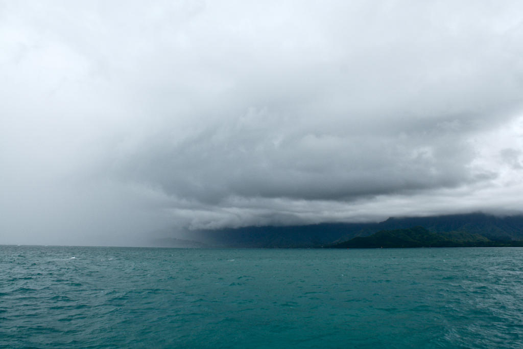
A deep swath of tropical moisture is moving over the islands from the south

There are thunderstorms embedded in this large cloud field

Classic comma shaped…upper level trough of low pressure

Showers…some are heavy (yellow and red colors) – Looping radar image
~~~ Hawaii Weather Narrative ~~~
Small Craft Advisory…Windiest coasts and channels around Kauai and Oahu
Satellite imagery shows an upper trough of low pressure over the state…with an embedded low centered just west of Kauai. The upper low is inducing a surface low northwest of Kauai, which is slowly moving north. The low is dragging a band of deep layered clouds over the state…stretching from Oahu to the Big Island. Radar shows numerous showers with embedded thunderstorms streaming north within this convergence band. The showers and thunderstorms will produce heavy rain at times tonight, and with already saturated soils across the state, there will be the potential for flash flooding over most of the state. A Flash Flood Watch remains in effect from Oahu to the Big Island until 6am Thursday.
This low will also bring breezy south winds over most of the state tonight…with decreasing winds Thursday as the low lifts away. Winds could also become locally strong in the vicinity of heavy showers and thunderstorms tonight. At the higher elevations, the Big Island Summits will experience much stronger winds, coupled with a chance for snowfall tonight. Blowing and drifting snow will likely considerably reduce visibility, and a Blizzard Warning remains in effect. By Thursday morning, the main dynamic forcing associated with the upper trough, should be north of the island chain. Thus, the threat for flash flooding and thunderstorms will begin to diminish…however some remnant showers are likely to linger through the day.
A ridge of high pressure will build over the island chain Thursday night through Friday night…further diminishing the shower activity. Winds will remain southerly through this period and into the weekend, which will push volcanic haze (vog) over the smaller islands…and keep humid conditions across the state. A weakening cold front is forecast to move over the western islands during the weekend. The front will stall early next week, eventually increasing showers across the entire island chain. There continues to be some uncertainty about the exact details, although we should expect increasing showers across Kauai and Oahu this weekend…perhaps extending further east towards Maui County and the Big Island with time.
Here’s a wind profile of the Pacific Ocean – Closer view of the islands / Here’s the vog forecast animation / Here’s the latest weather map
Marine environment details: A surface low just west of Kauai will continue to track northward through Thursday, as an upper level trough moves over the state. Hazardous conditions including gusty winds, hail, and thunderstorms with frequent lightning can be expected through tonight over the coastal waters…mainly from the Kaiwi Channel eastward.
A Small Craft Advisory (SCA) is posted over coastal waters from Oahu eastward for strong south kona winds ahead of the low. Winds should begin to ease as the surface low lifts north.
Swells and surf will remain relatively quiet until this weekend. A developing gale to storm force low northwest of Kauai, should direct a moderate west-northwest swell towards the islands. Guidance shows the swell peaking late Saturday into Sunday, producing near to low end advisory level surf for the exposed north and west facing shores. Elsewhere, no significant surf expected.
There are heavy showers offshore…stretching over the islands locally
Southern California Weather Summary: High pressure building in over the area will bring a warming trend through Friday. Then, an onshore flow will become established Saturday, prompting overnight clouds, fog…and cooler temperatures. A low pressure system will arrive Sunday, bringing a slight chance of rain across the central coast. Warmer weather again next week.

Mostly clear across Southern California tonight
World-wide tropical cyclone activity
![]()
>>> Atlantic Ocean: The 2017 hurricane season begins June 1st
Here’s a satellite image of the Atlantic Ocean
>>> Caribbean: The 2017 hurricane season begins June 1st
>>> Gulf of Mexico: The 2017 hurricane season begins June 1st
Here’s a satellite image of the Caribbean Sea…and the Gulf of Mexico
Here’s the link to the National Hurricane Center (NHC)
>>> Eastern Pacific: The 2017 hurricane season begins May 15th
Here’s the NOAA 2016 Hurricane Season Summary for the Eastern Pacific Basin
Here’s a wide satellite image that covers the entire area between Mexico, out through the central Pacific…to the International Dateline.
Here’s the link to the National Hurricane Center (NHC)
>>> Central Pacific: The 2017 hurricane season begins June 1st
Here’s the NOAA 2016 Hurricane Season Summary for the Central Pacific Basin
Here’s a link to the Central Pacific Hurricane Center (CPHC)
>>> Northwest Pacific Ocean: No active tropical cyclones
>>> North and South Indian Oceans / Arabian Sea: No active tropical cyclones
Here’s a link to the Joint Typhoon Warning Center (JTWC)
Interesting: Signy Island is hottest place in the Antarctic – A World Meteorological Organization (WMO) committee of experts announces this week (Wed 1 March) new records for the highest temperatures recorded in the Antarctic Region. The results are part of continuing efforts to expand a database of extreme weather and climate conditions throughout the world.
A temperature of +19.8°C (67.6°F) measured at British Antarctic Survey’s Signy Research Station on Borge Bay on the South Orkney Islands on 30 January 1982 is a record for the Antarctic region (defined as “all land and ice shelves south of 60°S”). The committee reached this conclusion after examining temperature data from the Antarctic since records began in the late 1950s.
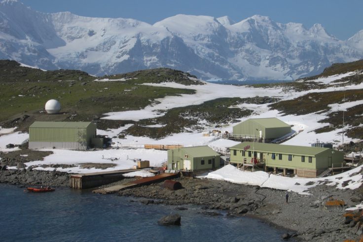
So what caused temperatures at Signy to reach levels more typical of a summer day in the UK than those experienced across much of the Antarctic?
BAS meteorologist Dr John King, a member of the WMO expert committee, explains:
“Summer temperatures at Signy can sometimes reach double figures, but this event in January 1982 is pretty unusual. Weather systems in the South Atlantic were bringing exceptionally warm subtropical air southwards towards Signy that year. As this air moved south across the cold Southern Ocean it cooled at low levels but remained very warm above 1 km altitude. This warm air was brought back towards the surface as the air flowed over the mountainous Coronation Island just to the north of Signy – a phenomenon known as a föhn wind. Although average temperatures at Signy have been rising at around 0.2°C per decade, the highest temperature we’ve measured since January 1982 has been 13.8°C, showing just how exceptional that event was.”
The committee also confirms that the temperature of +17.5°C (63.5°F) measured at the Argentinian station of Esperanza in the Antarctic Peninsula on 24 March 2015 is a record for the Antarctic continent. It also reports an observation of -7.0°C (19.4°F), made on 28 December 1980 at an automatic weather station in Adélie Land is a record for the Antarctic plateau above 2500 m elevation.
The lowest temperature yet recorded by ground measurements for the Antarctic Region, and for the whole world, was ?89.2°C (-128.6°F) at Vostok station on 21 July 1983.
Dr King continues:
“Global temperatures are rising and we are witnessing big changes in the polar regions such as the recent rapid reduction of Arctic summer sea ice. Determining temperature extremes for a region is important as it sets a baseline against which climate variability and change can be measured. BAS currently monitors temperature and a range of other climate variables at its five permanent research stations and at a number of remote automatic weather stations scattered across the sub Antarctic islands and the Antarctic Peninsula. These data are shared with the international climate research community and underpin studies of Antarctic climate variability and change.”
Spanning 14 million km2 (roughly twice the size of Australia), the Antarctic is cold, windy and dry. The average annual temperature ranges from about ?10°C on the Antarctic coast to ?60°C at the highest parts of the interior. Its immense ice sheet is up to 4.8km thick and contains 90% of the world’s fresh water, enough to raise sea level by around 60 metres were it all to melt. The Antarctic Peninsula (the northwest tip near to South America) is among the fastest warming regions of the planet, almost 3 C over the last 50 years. The majority of glaciers along the west coast of the Antarctic Peninsula have retreated in the last 50 years with most of these showing accelerated retreat in the last 12 years.
Nancy Says:
Aloha Glenn,
Cool, thanks for the additional So Cal weather summary, as my daughter lives down there (in Burbank).
Sending well wishes to you & your mom.
Nancy
~~~ Hi Nancy, good to hear from you there in Sonoma County. You’re very welcome, it seems appropriate to give a few words, and show a satellite image of Southern California, as long as I’m currently living here…taking care of my Mom. Thanks for your well wishes to us!
Aloha, Glenn
woody adamz Says:
Hi Glen, been jammin and readying for visit by daughter and couple of friends, after TWENTY or so years. Having to build a bit to accommodate….quite a “boogie”..THAT,plus other Pertinent and imminent things that are now pressing…Whew. A Marathon! How’s your Mom coming along? Is the therapist accomplishing much…sure hope so. Yet, at 94, Every THING goes quite a but Slower. Please relay my apologizes to her and let her know that my thoughts & prayers are a daily happening and give her a hug from me…I won’t even Ask how you’re doing as I’ve “Done the Dance” and know what it entails. Still, I send my Best Wishes for your well being as you devote yourself to this work, which requires a Selfless Love that only experience endows…Much Aloha to you both. What a neat pic of that beautiful sister “emitting” that rainbow from her palm…It’s Classic….Again…Aloha Nui.
~~~ Hi Woody, nice to hear that your daughter and old friends will be visiting soon…enjoy their company!
Thanks for asking about my Mom, she is coming along steadily, not fast, but steady…thank goodness. I’ll pass along your well wishes to her.
Indeed, it’s a new part of my life, taking care of my Mom, after her supporting me all her life. I’m enjoying this job for the most part, although of course I miss my friends there in Hawaii.
Glad you enjoyed the rainbow picture.
Aloha, Glenn
Steve Says:
Aloha Glenn,
Best wishes for your mother’s continued improvement…in the meantime how about a little commentary on SoCal weather…it’s been dramatic and your the best weatherman out there!
From Honolulu, but temporarily in San Diego,
Steve
~~~ Hi Steve, good to hear from you, and thank you so much for your well wishes for my Mom’s improvement! She is steadily improving, although it continues to be quite slow, which I think is normal for a lady in her middle 90’s. I still have high hopes that she’ll gain more strength.
I appreciate your positive feedback on my weather skills too. As for covering the weather here in Southern California, hmmm, I hadn’t thought of that. Let me consider this, and perhaps adding a small paragraph covering this small part of the southern west coast. Thanks for the prompting! By the way, I wonder if you were here about a week ago, when that big wind and rain storm hit our area!?
Have a good time in San Diego while you’re there, and then back home in your own state of Hawaii.
Aloha, Glenn