


Air Temperatures – The following high temperatures (F) were recorded across the state of Hawaii Thursday…along with the low temperatures Thursday:
81 – 71 Lihue, Kauai
81 – 68 Honolulu, Oahu
84 – 64 Kahului AP, Maui
82 – 71 Kona Int’l AP
82 – 68 Hilo AP, Hawaii
Here are the latest 24-hour precipitation totals (in inches) for each of the islands as of Thursday evening:
0.06 Mount Waialeale, Kauai
0.01 Poamoho RG 1, Oahu
0.00 Molokai
0.00 Lanai
0.00 Kahoolawe
0.00 Maui
0.14 Piihonua, Big Island
The following numbers represent the strongest wind gusts (mph) as of Thursday evening:
12 Puu Lua, Kauai
12 Waianae Valley, Oahu
09 Molokai
08 Lanai
28 Kahoolawe
22 Hana, Maui
24 South Point, Big Island
Here’s a wind profile of the Pacific Ocean – Closer view of the islands – Here’s the Hawaiian Islands NOAA Vog model animation
Hawaii’s Mountains – Here’s a link to the live webcam on the summit of our tallest mountain Mauna Kea (nearly 13,800 feet high) on the Big Island of Hawaii. This webcam is available during the daylight hours here in the islands, and at night whenever there’s a big moon shining down. Also, at night you will be able to see the stars — and the sunrise and sunset too — depending upon weather conditions.
Aloha Paragraphs

Low pressure systems are active well north through northwest of the islands, while a high pressure system is located to our northeast, keeping light south to southeasterly breezes over the Hawaiian Islands…with volcanic haze

A cold front is approaching to the northwest, with a prefrontal cloud band with showers…nearing Kauai

Clear to partly cloudy, with showers out ahead of the approaching cold front, getting close to Kauai

Just a few showers – Looping radar image
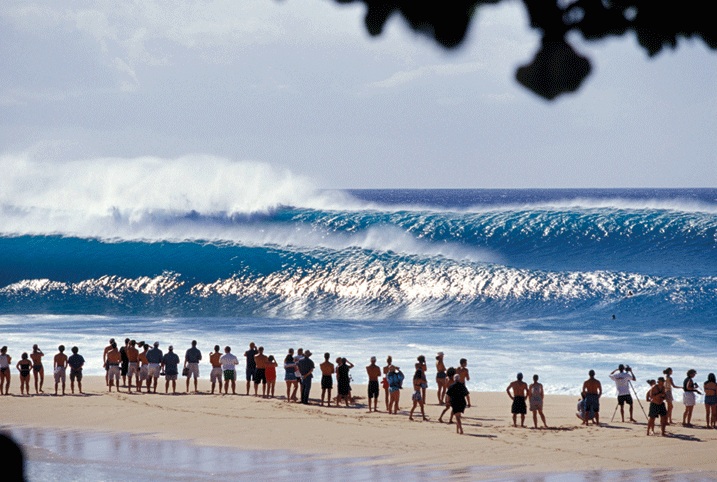
High Surf Warning…north and west facing shores of Kauai, Oahu, Molokai and north shore of Maui, and the Big Island west shore
Small Craft Advisory…most coastal and channel waters for high seas
~~~ Hawaii Weather Narrative ~~~
The winds remain light, with daytime sea breezes…and volcanic haze over many areas. Here’s the latest weather map, showing low pressure centers well to the north through northwest of Hawaii…with an associated cold front approaching to the northwest of the islands. Meanwhile, we find a high pressure system to the northeast of the islands…with an associated ridge over the central islands. Low pressure systems and their associated cold fronts will keep the ridge of high pressure over us…through the rest of the week. This will keep our atmosphere stable, and at the same time volcanic haze (vog) around as well. Looking even further ahead, we’ll see the return of trade winds early next week, which will help to whisk the voggy conditions away then. As these more normal trades fill back into the state, we’ll finally have less stagnant weather conditions in place.
Mainly dry weather…although Kauai and the Big Island could see an increase in showers today. At the same time, there will be the chance of some very minor afternoon upcountry showers here and there, especially over the Big Island. Meanwhile, our atmosphere continues to be dry and stable, with any showers remaining sparse for the most part. A cold front continues to approach the state, although will stop short of reaching Kauai, as they’ve been doing lately. However, some prefrontal clouds out ahead of the actual frontal boundary, may bring some limited increase in showers to Kauai. As we push into the weekend, this dry and rather mellow weather pattern will continue over the islands. As the trade winds return early next week, there may be a few windward showers…although not many are expected.
Marine environment details: The current northwest swell continues to subside. Surf from this swell has dropped below the high surf advisory level.
A hurricane force low in the north Pacific has produced a very large west-northwest swell headed toward the islands. Forerunners from this swell had reached the northwest buoy. Surf along exposed north and west facing shores will build above the High Surf Warning level Friday morning on the smaller islands. Since this swell will be coming from a west-northwest direction, the surf will be partly blocked by Kauai and Niihau, so surf will be smaller on Oahu than Kauai County. On the other hand, this west-northwest direction will allow quite a bit of the swell energy to pass south of Kauai and reach west facing shores of the Big Island. Surf is expected to reach the High Surf Warning level on the west facing shores of the Big Island by Friday evening.
Another very large swell is likely around the middle of next week, but there is some uncertainty about the exact size and timing of the swell.
The high pressure ridge near the islands will keep winds over the coastal waters relatively light through the weekend, so no Small Craft Advisories for winds are expected over the next few days. Combined seas will rise above the Small Craft Advisory threshold in areas of the coastal waters exposed to the large swell. Locally strong trades may return by the middle of next week as high pressure builds northeast of the area.
A few showers near Kauai, otherwise remaining generally dry, very large surf north and west shores
World-wide tropical cyclone activity…with storms showing up when active
![]()
>>> Atlantic Ocean: The 2016 hurricane season has ended
Here’s a satellite image of the Atlantic Ocean
>>> Caribbean: The 2016 hurricane season has ended
>>> Gulf of Mexico: The 2016 hurricane season has ended
Here’s a satellite image of the Caribbean Sea…and the Gulf of Mexico
Here’s the link to the National Hurricane Center (NHC)
>>> Eastern Pacific: The 2016 hurricane season has ended
Here’s the NOAA 2016 Hurricane Season Summary for the Eastern Pacific Basin
Here’s a wide satellite image that covers the entire area between Mexico, out through the central Pacific…to the International Dateline.
Here’s the link to the National Hurricane Center (NHC)
>>> Central Pacific: The 2016 hurricane season has ended
Here’s the NOAA 2016 Hurricane Season Summary for the Central Pacific Basin
Here’s a link to the Central Pacific Hurricane Center (CPHC)
>>> South Pacific Ocean: No active tropical cyclones
>>> North and South Indian Oceans / Arabian Sea: No active tropical cyclones
Here’s a link to the Joint Typhoon Warning Center (JTWC)
Interesting: Affordable water in the US: A burgeoning crisis – If water rates continue rising at projected amounts, the number of U.S. households unable to afford water could triple in five years, to nearly 36 percent, finds new research by a Michigan State University scholar.
Elizabeth Mack said a variety of factors, ranging from aging infrastructure to climate change to population decline in urban areas, are making residents’ ability to afford water and wastewater services a burgeoning crisis. Published online today in the journal PLOS ONE, her study is one of the first nationwide investigations of water affordability.
“In cities across the United States, water affordability is becoming an increasingly critical issue,” said Mack, an assistant geography professor who analyzed water consumption, pricing and demographic and socioeconomic data for the study.
Spending on water and wastewater services combined should make up no more than 4.5 percent of household income, the Environmental Protection Agency recommends. Based on that criteria, some 13.8 million U.S. households (or 11.9 percent of all households) may find water bills unaffordable – a hardship that hits poor families particularly hard, Mack said.
Water rates have increased 41 percent since 2010, and if they continue at that pace over the next five years the number of households that cannot afford water and wastewater services could soar to an estimated 40.9 million, or 35.6 percent of all households.
One driving factor is aging infrastructure. Experts say it will cost more than $1 trillion to replace World War II-era water systems over the next 25 years. Another pressure is climate change, as more intense weather events fuel a need for improvements to wastewater facilities. Making such adaptations will cost the United States more than $36 billion by 2050, according to estimates.
Further, shrinking populations in major cities such as Detroit and Philadelphia means fewer people to pay for the large fixed cost of water service. Some 227,000 customers in Philadelphia, or 4 out of 10 water accounts, are past due, while 50,000 delinquent customers in Detroit have had their water service terminated since the start of 2014, the study says. Households in Atlanta and Seattle are paying more than $300 a month for water and wastewater services (based on a family of four).
Ultimately, the study says, governments, utilities and consumers will need to work together to solve the growing affordability problem.
“Water is a fundamental right for all humans,” Mack said. “However, a growing number of people in the United States and globally face daily barriers to accessing clean, affordable water.”
The United States remains a relatively understudied country in international work on water affordability issues, she noted.
“The hope is that enhanced awareness of this issue in the developed world will highlight the severity of the issue, which is not isolated to people in the developing world,” Mack said.