


Air Temperatures – The following maximum temperatures (F) were recorded across the state of Hawaii Saturday along with the low temperatures Saturday:
84 – 75 Lihue, Kauai
87 – 73 Honolulu, Oahu
86 – 75 Molokai AP
87 – 74 Kahului AP, Maui
88 – 75 Kailua Kona
83 – 71 Hilo AP, Hawaii
Here are the latest 24-hour precipitation totals (in inches) for each of the islands as of Saturday evening:
0.05 Mount Waialeale, Kauai
0.07 Poamoho RG 1, Oahu
0.04 Molokai
0.00 Lanai
0.00 Kahoolawe
0.52 West Wailuaiki, Maui
0.96 Saddle Quarry, Big Island
The following numbers represent the strongest wind gusts (mph) as of Saturday evening:
18 Poipu, Kauai
24 Makua Range, Oahu
23 Molokai
24 Lanai
28 Kahoolawe
27 Kapalua, Maui
30 Kealakomo, Big Island
Hawaii’s Mountains – Here’s a link to the live webcam on the summit of our tallest mountain Mauna Kea (nearly 13,800 feet high) on the Big Island of Hawaii. This webcam is available during the daylight hours here in the islands, and at night whenever there’s a big moon shining down. Also, at night you will be able to see the stars — and the sunrise and sunset too — depending upon weather conditions.
Aloha Paragraphs

A weakening cold front north of Hawaii is approaching our islands

Thunderstorms southwest through southeast

Scattered clouds locally, otherwise quite clear in many areas

Barely a shower in sight – Looping radar image
High Surf Advisory…North and West shores Kauai through Maui
~~~ Hawaii Weather Narrative ~~~
Trade winds will blow in the light to moderately strong range through this weekend into Monday, then rebound Tuesday onward. Here’s the latest weather map, showing a moderately strong high pressure system to the northwest of Hawaii. Our active trade wind flow will remain in place through the next week, with no definite end in sight.
Here’s a wind profile of the offshore waters around the islands – and a closer look
Here’s the Hawaiian Islands Sulfate Aerosol animated graphic, showing vog forecast
Fair weather will prevail through Sunday, with an increase in showers early Monday into Tuesday. Our weather should remain quite pleasant through this weekend, with just a few windward showers at times. The forecast shows a fairly minor area of moisture headed our way, from a weakening cold front. This will arriving during upcoming Discoverers’ Day (Monday) through Tuesday. Thereafter, a typical trade wind weather pattern will prevail Wednesday through the rest of next week.
Marine environment details: Winds have subsided ahead of the frontal band north of the area. Winds speed will rebound behind the shower band, and will likely remain strong through the rest of next week.
A new northwest swell has been building over the coastal waters. The swell will produce advisory level surf along north and west facing shores, peaking this evening, then gradually subsiding through Sunday. As this swell fades, a northwest swell generated from former Tropical Cyclone Chaba, in the western Pacific, will arrive Monday, peak on Tuesday, then decline on Wednesday. The later swell will be a bit smaller, and surf from that swell may not quite reach the advisory threshold.

Surf remains up along the north and west facing beaches, more coming
World-wide tropical cyclone activity..
Here is some useful information about Matthew:
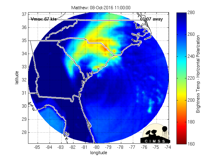
Post-Tropical Cyclone Matthew has 75 mph sustained winds…over the Outer Banks of North Carolina
Here’s the latest satellite image Matthew, with the looping version…and what the computer models are showing
NWS Looping radar from Wilmington, North Carolina
NHC Tropical Storm Force Wind Speed Probability graphic
NOAA enhanced animated satellite image
Looping radar image, showing Matthew moving through the Bahamas, along the Florida coast, and on up the Georgia and the Carolina’s
The Windytv wind profile of Matthew
The current wind speed and directions for area around Matthew
![]()
>>> Atlantic Ocean:
Tropical Storm 15L (Nicole) is located approximately 575 miles south of Bermuda. Here’s the NHC graphical track map, a satellite image, and what the computer models are showing
Here’s a satellite image of the Atlantic Ocean
>>> Caribbean:
Post-Tropical Cyclone 14L (Matthew) is located 100 miles east of Cape Hatteras, North Carolina. Here’s the NHC graphical track map, a satellite image, and what the computer models are showing
>>> Gulf of Mexico: No active tropical cyclones
Here’s a satellite image of the Caribbean Sea…and the Gulf of Mexico
Here’s the link to the National Hurricane Center (NHC)
>>> Eastern Pacific: No active tropical cyclones
Here’s a wide satellite image that covers the entire area between Mexico, out through the central Pacific…to the International Dateline.
1.) A large area of showers and thunderstorms, extending from several hundred miles south through southwest of the southern tip of the Baja California peninsula, is associated with a trough of low pressure. This disturbance is expected to gradually consolidate during the next couple of days, and a tropical depression is likely to form later this week while moving west-northwestward to northwestward.
* Formation chance through 48 hours…low…20 percent
* Formation chance through 5 days…high…70 percent
2.) An area of disorganized showers and thunderstorms is located a couple of hundred miles south of the coasts of El Salvador and Guatemala. Environmental conditions are expected to generally be conducive for development, and a tropical depression is likely to form later this week while this system moves westward and then west-northwestward.
* Formation chance through 48 hours…low…20 percent
* Formation chance through 5 days…high…70 percent
Here’s the link to the National Hurricane Center (NHC)
>>> Central Pacific: No active tropical cyclones
1.) A poorly organized area of showers and thunderstorms, located about 690 miles southeast of Hilo, Hawaii, is associated with an area of low pressure. Development, if any, of this system will be slow to occur as it moves generally westward near 10 mph over the next several days.
* Formation chance through 48 hours…low…20 percent
Here’s a link to the Central Pacific Hurricane Center (CPHC)
Tropical Storm 22W (Aere) remains active, located approximately 208 NM east of Hong Kong. Here’s the JTWC graphical track map, a satellite image, and what the computers models are showing
Tropical Storm 23W (Songda) remains active, located approximately 204 NM east-southeast of Iwo To, Japan. Here’s the JTWC graphical track map, a satellite image, and what the computers models are showing
>>> South Pacific Ocean: No active tropical cyclones
>>> North and South Indian Oceans / Arabian Sea: No active tropical cyclones
Here’s a link to the Joint Typhoon Warning Center (JTWC)
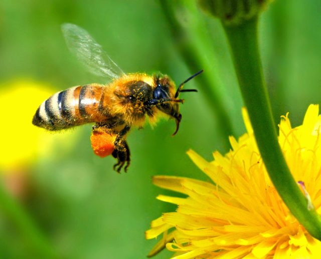
Interesting: To Help Bees, Skip Herbicides and Pesticides, Keep Lawns Naturally Diverse – Declining populations of pollinators is a major concern to ecologists because bees, butterflies and other insects play a critical role in supporting healthy ecosystems. Now a new study from urban ecologists at the University of Massachusetts Amherst suggests that when urban and suburban lawns are left untreated with herbicides, they provide a diversity of “spontaneous” flowers such as dandelions and clover that offer nectar and pollen to bees and other pollinators.
Private lawns make up a significant part of urban lands in the United States, an estimated 50 percent of city and suburbs, say Susannah Lerman and co-author Joan Milam, an adjunct research fellow in environmental conservation. They write, “Practices that support nesting and foraging opportunities for bees could have important implications for bee conservation in suburban areas.”
Lerman, an adjunct UMass Amherst faculty member who is also with the U.S. Forest Service, says, “We are still surprised at how many bees we found on these untreated lawns.”
In this study of lawns in suburban Springfield, Mass., she and Milam found that “spontaneous lawn flowers could be viewed as supplemental floral resources and support pollinators, thereby enhancing the value of urban green spaces.” Details appear in the current issue of Annals of the Entomological Society of America.
For this study, supported by the National Science Foundation, the researchers enlisted owners of 17 lawns in suburban Springfield. Between May 2013 and September 2014, the homeowners did not apply chemical pesticides or herbicides to lawns.
“We documented 63 plant species in the lawns, the majority of which were not intentionally planted,” the authors report. Lerman and Milam visited each yard six times per year for two years, collecting a total of 5,331 individual bees representing 111 species, of which 97 percent were native to North America.
Of particular interest was the discovery of a large population of Lasioglossum illinoense, a widespread sweat bee species and common in its range, but known in Massachusetts only from a single specimen collected in the late 1920s. The population of L. illinoense in Springfield lawns documents the northeastern range limit for this species.
Conserving native bees for their vital pollination services is of national interest, Lerman and Milam point out, and this new information on native bee distribution and abundance is important for making informed conservation and management decisions regarding pollinator conservation.
Overall, one of their main findings, say Lerman and Milam, is that “when lawns are not intensively managed, lawn flowers can serve as wildlife habitat and contribute to networks of urban green spaces.”
Further, “developing outreach to homeowners and lawn care companies to encourage, rather than eliminate, lawn flowers such as dandelions and clover and thin grass cover or bare spots could be a key strategy for urban bee conservation programs targeting private yards.”
Michael G McCallister Says:
Glenn;
Since the “Maui News” has changed their format, I cannot find a link to the weather tab, hence have to find your site by logging directly. It’s kind of interesting that the new format for the “Maui News” doesn’t have a link.
~~~ Hi Michael, after many folks let me know that the Maui News had dropped the link to my website, I called the publisher. He let me know that they were going to be adding a new link to my site, although as you point out, they haven’t done that yet.
Hopefully by Monday, or sooner, it will reappear.
Thanks, Glenn