


Air Temperatures – The following maximum temperatures (F) were recorded across the state of Hawaii Friday along with the low temperatures Friday:
85 – 75 Lihue, Kauai
86 – 75 Honolulu, Oahu
86 – 74 Molokai AP
89 – 68 Kahului AP, Maui
88 – 78 Kailua Kona
81 – 70 Hilo AP, Hawaii
Here are the latest 24-hour precipitation totals (in inches) for each of the islands as of Friday evening:
0.17 Kapahi, Kauai
0.19 Poamoho RG, Oahu
0.00 Molokai
0.00 Lanai
0.00 Kahoolawe
0.73 West Wailuaiki, Maui
1.82 Saddle Quarry, Big Island
The following numbers represent the strongest wind gusts (mph) as of Friday evening:
18 Poipu, Kauai
27 Oahu Forest NWR, Oahu
28 Molokai
28 Lanai
27 Kahoolawe
31 Maalaea Bay, Maui
24 Waikoloa, Big Island
Hawaii’s Mountains – Here’s a link to the live webcam on the summit of our tallest mountain Mauna Kea (nearly 13,800 feet high) on the Big Island of Hawaii. This webcam is available during the daylight hours here in the islands, and at night whenever there’s a big moon shining down. Also, at night you will be able to see the stars — and the sunrise and sunset too — depending upon weather conditions.
Aloha Paragraphs

A gale low with its weak cold front north of Hawaii

Thunderstorms southwest and southeast

Scattered clouds offshore, over the windward sides and mountains locally too, high cirrus southwest

Showers over the islands locally – Looping radar image
High Surf Advisory…North and West shores Kauai through Maui
~~~ Hawaii Weather Narrative ~~~
The trade winds will blow in the light to moderately strong range through the weekend, then rebound early next week. Here’s the latest weather map, showing moderately strong high pressure systems well to the northeast and northwest of Hawaii. Our refreshing trade winds will remain in place through the next week, with no definite end in sight.
Here’s a wind profile of the offshore waters around the islands – A closer look
Here’s the Hawaiian Islands Sulfate Aerosol animated graphic, showing vog forecast
Fair weather will prevail through the rest of the week, with a chance of showers early next week. Our weather should remain quite pleasant through the weekend, with just a few windward showers at times. The models show a fairly minor area of moisture from an old cold front arriving early next week and lasting into mid-week, mostly over the Kauai and Oahu end of the island chain.
Marine environment details: A small craft advisory remains posted for winds near advisory levels over the waters near Maui and the Big Island.
The incoming northwest swell is just starting to show up on the buoy to the northwest of the islands. The current forecast has surf rising to advisory levels by daybreak, peaking Saturday night, and subsiding Sunday. A high surf advisory has been posted for the north and west shores of the smaller islands exposed to this swell. The next swell, which is expected to arrive Monday will once again boost surf, but the latest model run indicates the it may not be as big as previous runs indicated.

Rising surf along our north and west facing beaches
World-wide tropical cyclone activity..
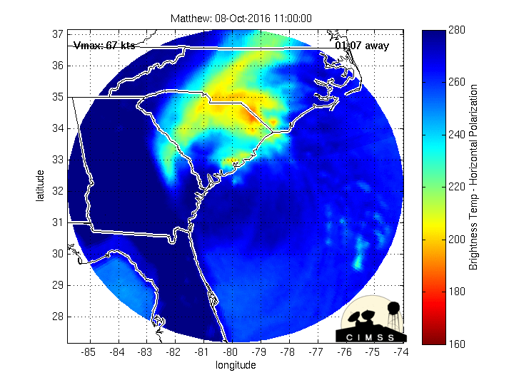
Here is useful information about Hurricane Matthew:
Hurricane 14L (Matthew) is a category 1 hurricane (85 mph sustained winds)…brushing the South Carolina coast
Here’s the latest satellite image of this hurricane, with the looping version…and what the computer models are showing
NWS Looping radar from Charleston, South Carolina
NHC Tropical Storm Force Wind Speed Probability graphic
NOAA enhanced animated satellite image
Looping radar image, showing hurricane Matthew moving through the Bahamas towards Florida and Georgia
The Windytv wind profile of hurricane Matthew…offshore from Georgia
The current wind speed and directions for area around Hurricane Matthew
![]()
>>> Atlantic Ocean:
Tropical Storm 15L (Nicole) is located approximately 499 miles south of Bermuda. Here’s the NHC graphical track map, a satellite image, and what the computer models are showing
Here’s a satellite image of the Atlantic Ocean
>>> Caribbean:
Hurricane 14L (Matthew) remains a category 1 hurricane. Located approximately 20 miles south-southeast of Charleston, South Carolina. Here’s the NHC graphical track map, a satellite image, and what the computer models are showing
>>> Gulf of Mexico: No active tropical cyclones
Here’s a satellite image of the Caribbean Sea…and the Gulf of Mexico
Here’s the link to the National Hurricane Center (NHC)
>>> Eastern Pacific: No active tropical cyclones
Here’s a wide satellite image that covers the entire area between Mexico, out through the central Pacific…to the International Dateline.
1.) A large area of disorganized showers and thunderstorms extending from several hundred miles south through southwest of the southern tip of the Baja California peninsula is associated with a trough of low pressure. Environmental conditions are expected to be conducive for gradual development of this disturbed weather, and a tropical depression is likely to form by the early or middle part of next week while this system moves west-northwestward.
* Formation chance through 48 hours…low…20 percent
* Formation chance through 5 days…high…70 percent
2.) An area of low pressure is expected to develop several hundred miles south or southwest of the south-central coast of Mexico by early next week. Environmental conditions are expected to be conducive for development while the low moves westward or west-northwestward.
* Formation chance through 48 hours…low…near 0 percent
* Formation chance through 5 days…medium…50 percent
Here’s the link to the National Hurricane Center (NHC)
>>> Central Pacific: No active tropical cyclones
1.) A poorly organized area of showers and thunderstorms, located 740 miles southeast of Hilo, Hawaii, is associated with an area of low pressure. Development, if any, of this system will be slow to occur as it moves generally westward near 10 mph during the next several days.
* Formation chance through 48 hours…low…20 percent
Here’s a link to the Central Pacific Hurricane Center (CPHC)
Tropical Storm 22W (Aere) remains active, located approximately 172 NM east-southeast of Hong Kong. Here’s the JTWC graphical track map, a satellite image, and what the computers models are showing
Tropical Depression 23W (Songda) is now active, located approximately 776 NM east-southeast of Iwo To, Japan. Here’s the JTWC graphical track map, a satellite image, and what the computers models are showing
>>> South Pacific Ocean: No active tropical cyclones
>>> North and South Indian Oceans / Arabian Sea: No active tropical cyclones
Here’s a link to the Joint Typhoon Warning Center (JTWC)
Interesting: Bees Are Declared Endangered for the First Time in the U.S. – For the first time in history, a group of bees in the U.S. will be protected under the Endangered Species Act, following a recent announcement from wildlife officials.
The group of bees, who are commonly known as yellow-faced bees because of the markings on their faces, are endemic only to the Hawaiian islands. While there are dozens of species, scientists identified several of them who are at risk of extinction and have been calling for their protection for years.
In 2009, the Xerces Society for Invertebrate Conservation petitioned the U.S. Fish and Wildlife Service (FWS) to protect seven of the most at risk species under the U.S. Endangered Species Act, and now it’s celebrating a win for these bees.
The listing protects seven species, including Hylaeus anthracinus, Hylaeus longiceps, Hylaeus assimulans, Hylaeus hilaris, Hylaeus kuakea and Hylaeus mana.
The listing unfortunately doesn’t come with a designation of critical habitat, but hopefully that will change after the FWS analyzes more sites. Gregory Koob, conservation and restoration team manager for the FWS in Honolulu, told the AP that for now the listing will allow for recovery programs, more funding and will limit their harm from outside sources.
These bees face a host of threats ranging from habitat loss and fragmentation due to development, pollution, wildfires, invasive plants and animals and climate change. It’s hoped that by helping these bees survive, the native plants they rely on – some of which are also endangered – will also survive with them, and in turn provide food for other wildlife.
“The USFWS decision is excellent news for these bees, but there is much work that needs to be done to ensure that Hawaii’s bees thrive,” wrote Matthew Shepherd, Communications Director for the Xerces Society.
Now that these bees are protected, more may be on their way. Just weeks ago, the FWS announced it was also considering listing the rusty-patched bumblebee, who is also at risk of going extinct. Hopefully, they will also get the protection they need and help raise awareness about the need for urgent action to protect pollinators from the growing number of threats they face.