


Air Temperatures – The following maximum temperatures (F) were recorded across the state of Hawaii Tuesday…along with the low temperatures Tuesday:
82 – 70 Lihue, Kauai
84 – 76 Honolulu, Oahu
92 – 75 Molokai AP
93 – 75 Kahului AP, Maui – record 94…back in 1953
89 – 76 Kona AP
86 – 71 Hilo AP, Hawaii
Here are the latest 24-hour precipitation totals (inches) for each of the islands…Tuesday:
1.97 Kilohana, Kauai
1.31 Mililani, Oahu
0.00 Puu Alii, Molokai
0.00 Lanai
0.01 Kahoolawe
1.23 Hana AP, Maui
3.26 Laupahoehoe, Big Island
The following numbers represent the strongest wind gusts (mph)…Tuesday:
25 Mana, Kauai
25 Kuaokala, Oahu
23 Molokai
09 Lanai
22 Kahoolawe
23 Kahului AP, Maui
28 South Point, Big Island
Hawaii’s Mountains – Here’s a link to the live web cam on the summit of near 13,800 foot Mauna Kea on the Big Island of Hawaii. This web cam is available during the daylight hours here in the islands…and when there’s a big moon shining down during the night at times. Plus, during the nights you will be able to see stars, and the sunrise and sunset too…depending upon weather conditions.
Aloha Paragraphs

Darby is spinning well to the east of Hawaii, with Estelle following in Darby’s wake…along with former Celia moving away northwest of Kauai

Darby spinning towards the Hawaiian Islands…with a possible turn towards the northwest before reaching us

Darby…moving into the central Pacific today
![]()
What the models show for Darby

Estelle heading into higher latitudes…not a threat for Hawaii

Estelle peaking in strength…then remaining a tropical storm for several days
![]()
What the models are showing for Estelle

We see former Celia moving away to our northwest…with Darby spinning more or less in the direction of Hawaii

Former Celia with its low cloud swirl moving away from the islands…along with associated thunderstorms

Showers will be falling at times…a few quite generous – Looping radar image
Small Craft Advisory…windiest coasts and channels around Maui County and the Big Island
~~~ Hawaii Weather Narrative ~~~
Refreshing trades returning today…then lighter winds Friday into the weekend. Here’s the latest weather map, showing a very strong near 1040 millibar high pressure system in the area far north of Hawaii. At the same time, we see former tropical depression Celia moving away well to the northwest of our islands…steadily westward. Relatively cooler and more refreshing trade winds will return for a couple of days, before we see more muggy air arriving…as whatever is left of weakening tropical cyclone Darby likely moves by to the north of the state Friday into the weekend.
Here’s a wind profile…of the offshore waters around the islands – with a closer view
Here’s the Hawaiian Islands Sulfate Aerosol animated graphic – showing vog forecast
We’re back into a typical trade wind weather pattern…with just a few windward showers. As the trade winds return now, we’ll see our showers focusing on the windward sides. Meanwhile, as much weakened Darby gets closer to Hawaii towards Friday into the weekend, we could see this system bringing a weather change our way…stay tuned.
Marine environment details: As the remnant circulation of Celia moves away from the area, the pressure gradient will once again tighten in the island vicinity. A Small Craft Advisory has been issued for the typically windy waters around Maui County and The Big Island. Swells from Tropical Cyclone Darby will likely cause seas to exceed 10 feet over exposed waters by Friday. Also, depending on the eventual track of Darby winds may increase this weekend over the eastern waters.
Surf heights along east facing shorelines will continue to lower over the next couple of days. Swells from Tropical Cyclone Darby will begin to impact Maui County and the Big Island as early as Thursday, and move up the island chain into the weekend. Advisory level surf is expected with this swell. There will also be a series of small south swells throughout the forecast period.

Returning trade winds
World-wide tropical cyclone activity –
>>> Atlantic Ocean: No active tropical cyclones
Tropical cyclone formation is not expected during the next 5 days
Here’s a satellite image of the Atlantic Ocean
>>> Caribbean Sea: No active tropical cyclones
Tropical cyclone formation is not expected during the next 5 days
>>> Gulf of Mexico: No active tropical cyclones
Here’s a satellite image of the Caribbean Sea…and the Gulf of Mexico
Here’s the link to the National Hurricane Center (NHC)
>>> Eastern Pacific:
Darby continues to move westward…located about 1050 miles east of Hilo, Hawaii. Here’s the NHC graphical track map, along with a satellite image of this area…and the computer models are showing.
Estelle remains active well offshore from Mexico…located about 825 west-southwest of the southern tip of Baja California. Here’s the NHC graphical track map, along with a satellite image of this area…and the computer models are showing.
1.) A broad area of low pressure located about 550 miles south-southeast of Acapulco, Mexico, is producing disorganized showers and thunderstorms. Environmental conditions are expected to be conducive for gradual development of this system, and a tropical depression is likely to form during the next few days while it moves west-northwestward to northwestward at about 10 mph to the south of Mexico.
* Formation chance through 48 hours…low…30 percent
* Formation chance through 5 days…high…80 percent
2.) A weak low pressure area is located almost 1000 miles south of the southern tip of the Baja California peninsula. Environmental conditions are forecast to be marginally conducive for some development of this system later this week or this weekend while it moves west-northwestward at 10 to 15 mph.
* Formation chance through 48 hours…low…20 percent
* Formation chance through 5 days…medium…40 percent
Here’s a wide satellite image that covers the entire area between Mexico, out through the central Pacific…to the International Dateline.
Here’s the link to the National Hurricane Center (NHC)
>>> Central Pacific: No active tropical cyclones
1.) A weak surface low, the remnant of ex-Tropical Cyclone Celia,
is centered about 440 miles northwest of Lihue, Kauai. It was
moving west northwest near 20 mph. Atmospheric conditions are not
conducive for tropical cyclone redevelopment.
* Formation chance through 48 hours…low…near 0 percent.
Here’s a link to the Central Pacific Hurricane Center (CPHC)
>>> South Pacific Ocean: No active tropical cyclones
>>> North and South Indian Oceans / Arabian Sea: No active tropical cyclones
Here’s a link to the Joint Typhoon Warning Center (JTWC)
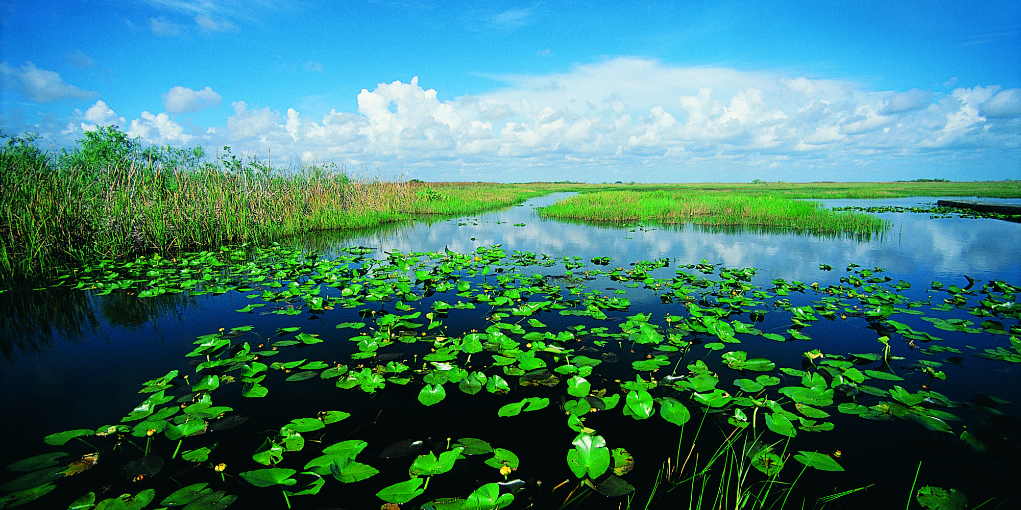
Interesting: Rising Seas Push Too Much Salt Into The Florida Everglades – The Florida Everglades is a swampy wilderness the size of Delaware. In some places along the road in southern Florida, it looks like tall saw grass to the horizon, a prairie punctuated with a few twisted cypress trees. The sky is the palest blue.
But beneath the surface a different story is unfolding. Because of climate change and sea level rise, the ocean is starting to seep into the swampland. If the invasion grows worse, it could drastically change the Everglades, and a way of life for millions of residents in South Florida.
An experiment is going on here to help scientists understand more about what’s likely to happen as the ocean invades. “We’re making, basically, artificial seawater here,” a guy wearing a mosquito net over his face tells me, as he stirs water in a vat the size of a hot tub.
The guy in the mosquito net is Joe Stachelek — a collaborator with Tiffany Troxler, from Florida International University. They’re making salt water and pumping it out into the wetland — dosing the plants and soil with their briny mix as a preview of what the ocean could do.
“As sea level rises,” Troxler explains, “the saltwater wedge moves inland.” And it infiltrates the bedrock.
“Our underlying rock is limestone,” Troxler says. “That limestone is very porous; it’s almost like Swiss cheese in some areas.”
We walk out into the test site — through the saw grass and the underlying peat, which is a fancy name for muck. It’s rich stuff, full of nutrients and microorganisms that feed this river of grass. And, like the plants, the peat also is affected by salt water.
The team has laid out a metal boardwalk, so you can walk around the muck without sinking up to your waist. Out here the grass is patchier, and in some places the peat is slumping — collapsing.
Troxler says there’s lots of this slumping going on. “When we start to lose the structure of the plants,” she explains, “essentially this peat, which is otherwise held together by roots, becomes a soupy pond.”
In response to the salt, the plants actually pull up some of their roots — out of the peat. The roots look like teeth protruding from receding gums.
This could be the future of the Everglades, Troxler says. And here’s the thing: The Everglades acts like sponge, feeding off the Biscayne aquifer — a giant cell of freshwater that lies underneath the land.
“We get over 90 percent of our freshwater from the Biscayne aquifer,” Troxler says, “we” meaning millions of people in South Florida.
As seawater seeps up from underneath, through the limestone bedrock, it is contaminating the aquifer and the Everglades above it.
That’s starting to worry some people. Like Julie Hill-Gabriel, who directs Everglades policy for the National Audubon Society in Florida. She says she tells people in South Florida, “What we do in the Everglades is 100 percent going to affect you in your neighborhood — [and whether] when you turn on the tap water, you have enough fresh clean water.”
For millennia, fresh water flowed south to the Everglades, making it the largest flooded grassland in America. But over the past several decades, that water was diverted to irrigate agricultural fields, and to keep homes from flooding. Environmental groups like Audubon have been trying to restore the natural flow to the Everglades, mostly to preserve wildlife.
Now, Hill-Gabriel says, there’s a new reason for that restoration — to repel the invading sea. Putting more freshwater back into the sponge that is the Everglades could create a kind of “back pressure” to keep seawater out.
“It just really compounds the urgency to move that freshwater south,” says Hill-Gabriel.
At least that’s the theory.
When it comes to climate change in South Florida, much of the focus until now has been about protecting property with pumps and barriers. But James Cason, the Republican mayor of the city of Coral Gables, says he hopes his constituents can understand the importance of protecting the Everglades as well.
“It’s not just so they can see the alligators,” Cason says. “It’s because they’ll want to make sure the drinking water on which we all depend is not contaminated.”
Dwight Says:
Thanks for the answer Glenn, like you I am grateful that we managed to miss a direct impact from all 15 of last years storms and those so far this year. I like your positive take on these cyclones, I agree, it is nice to have the additional summer rains. It will probably take a few more years to know if we are entering a new era of increased storms during hurricane season. If we are we will definitely have to keep our sense of humor and look for the positive. Plenty mahalos for keeping us informed!
Dwight
~~~ Yes Dwight, it is a bit early to begin calling anything a trend just yet…thus, I sort of side stepped one aspect of your question.
I am very happy to give updates on all these tropical cyclones, and their residual movements…and I will stay in the business of doing just that.
I appreciate your questions, and your insightful comments!
Aloha, Glenn
Sherine Cirullo Says:
Hi Glenn, I have been enjoying your post about the Hawaiian hurricanes this past week as we just arrived here yesterday in Kona. I find your website very informative. I am surprised by the number of hurricanes that come close to Hawaii. A question for you: we are here until July 27th,can you tell me which day do you think would be the best to go to see the volcano weather wise?
~~~ Hi Sherine, good to hear from you. Indeed, there certainly has been lots of tropical cyclones churning the waters of the eastern Pacific. Several of these, although retired, have influenced our weather here in the islands this summer.
As for the best day to visit Volcano, I’d recommend using this forecast page to determine that for yourself. This will give you the best option, based on what kind of weather you’d like to have that particular day.
http://www.hawaiiweathertoday.com/big-island.php
Best of luck, and enjoy that great part of the Big Island!
Aloha, Glenn
Dwight Says:
Aloha Glenn, maybe it’s because of last years record number of storms here in the central pacific and I am just paying more attention but is this a change in storm generation in the eastern and central pacific? It seems like we are going to be having a storm a week in a continuous manner being generated and launched in our general direction throughout the hurricane season. Possibly you have a broader perspective on this activity, is this the way it has always been and I just haven’t paid attention until last summer? Or is this the new normal with warmer water resulting from climate change?
Mahalo,
Dwight
~~~ Hi Dwight, good to hear from you again, and with your very good question. It’s true, we have recently had quite a parade of storms spinning up in the eastern Pacific…and moving into our central Pacific!
We’ve seen Agatha and Blas both bring showers to our islands, although both were retired by the time they arrived. Then we’ve had former Celia moving by just to our north, which is still happening at the time of my writing. Then, if all this hasn’t been enough, we have to keep a very close eye on tropical storm Darby.
Darby is now expected to remain at tropical storm strength as it gets close. The good thing here, is that Darby is expected to shift to the north of the islands this weekend…time will tell.
Then, there’s Estelle, which I’m not at all worried about…as she “breaks the spell”, so to speak, and keeps away from Hawaii.
Of course there are two other tropical disturbances gradually trying to spin up in the eastern Pacific, although we have plenty of time to wait for them to do their thing…to see what they have in mind as a course.
Like you, I do see the similarity that you point out, compared to last year’s El Nino hurricane season. I’m surprised as well, although, fortunately, we remain safe thus far.
I don’t mind these mild mannered retired storms, as they come close to the islands, they are sort of interesting to track, and they bring welcome precipitation during our typically dry summer season.
Let’s keep our fingers crossed that one of these storms doesn’t maintain its strength, and tries to cause trouble for us!
We’ll just have to keep watching, glad you are paying such close attention Dwight.
Aloha, Glenn