


Air Temperatures – The following maximum temperatures (F) were recorded across the state of Hawaii Wednesday…along with the minimums Wednesday:
85 – 75 Lihue, Kauai
85 – 77 Honolulu, Oahu
86 – 75 Molokai
93 – 74 Kahului AP, Maui – tied the record for Wednesday…back in 1984
88 – 77 Kailua Kona
88 – 72 Hilo, Hawaii
Here are the latest 24-hour precipitation totals (inches) for each of the islands, as of Wednesday evening:
2.59 Mohihi Crossing, Kauai
5.15 Schofield Barracks, Oahu
1.54 Molokai 1, Molokai
0.77 Lanai
0.52 Kahoolawe
1.66 Kula 1, Maui
1.53 Kapapala Ranch, Big Island
The following numbers represent the strongest wind gusts (mph)…as of Wednesday evening:
14 Moloaa Dairy, Kauai – NW
23 Kaneohe MCBH, Oahu – NW
07 Molokai – SE
10 Lanai – SW
13 Kahoolawe – SE
17 Kahului AP, Maui – SE
16 Upolu AP, Big Island – NE
Hawaii’s Mountains – Here’s a link to the live web cam on the summit of near 13,800 foot Mauna Kea on the Big Island of Hawaii. This web cam is available during the daylight hours here in the islands…and when there’s a big moon shining down during the night at times. Plus, during the nights you will be able to see stars, and the sunrise and sunset too… depending upon weather conditions.
Aloha Paragraphs

Hurricane 12E (Ignacio) continues spinning over the ocean well to
the east-southeast of Hawaii, and now Tropical Storm Jimena is
further to the east…with Tropical Storm Kilo located well to
the west-southwest of Hawaii

Hurricane 12E (Ignacio)…has its forecast track
pointing towards Hawaii – as a hurricane (H)

That’s Tropical Storm Kilo’s winds to the left of Hawaii, with Ignacio’s
to the right…along with Jimena’s coming into the picture further right

There are deep low pressure systems in our area…
in almost all directions
Here’s a real time wind profile…so we can keep an eye on
Tropical Storm Kilo (left) – Hurricane Ignacio (right)

Clear to partly cloudy skies

There are showers mostly offshore – looping radar image
Flash Flood Watch…across the entire state –
through this afternoon
~~~ Hawaii Weather Narrative ~~~
Our winds will remain light, generally from the southeast, with the trades returning Friday into the weekend…and then slipping away again early next week. Here’s the latest weather map, showing the Hawaiian Islands, and the rest of the North Pacific Ocean, along with a real-time wind profiler of the central Pacific. We find a moderately strong high pressure system far to the north of the state. At the same time we see low pressure systems/troughs in all directions. Our winds will be kept on the lighter side of normal, as these numerous low pressure systems continue to interrupt our normal trade wind flow. This light wind regime will keep muggy conditions over us Thursday. The trades, blowing in the light to moderately strong range, should return with more comfortable conditions by Friday into the weekend. As it stands now, a tropical cyclone is forecast to move close to, or by to our north early next week…our local winds then will depend greatly upon its eventual track.
Unsettled weather will remain over the state through Thursday…then some drying Friday into the weekend. The general air flow over our area, continues to carry lots of moisture up from the deeper tropics. The air will feel sultry during the days. There will continue to be off and on showers, and some possible thunderstorms over the islands during the afternoon hours Thursday. We continue to have a Flash Flood Watch covering the entire state…which runs through Thursday afternoon. Whatever thunderstorms and locally heavy rains that might move over the islands, would continue to cause flood advisories, or flood warnings here and there. As the trade winds return Friday into the weekend, with their drier weather…a few showers will favor the windward sides. As we push into early next week, conditions could shift right back into a wet reality again for a couple of days.
Hurricane 12E (ignacio) continues to spin in our direction…and may approach our area early next week. This system is one that we’re definitely watching very closely, even though it’s days and days away. I know the last three storms have veered away from us, however it only takes one to cause a big problem. As it looks from here, we could turn very wet again by early next week…with all manner of heavy weather coming our way. Then there’s always that chance that Ignacio might pass by to the north of the islands, having various less intense influences on our local weather. It’s too early to know the details, in terms of winds and rain, although not too early to be paying very close attention to the inevitable changes that will occur each day going forward. Here’s a satellite image, and the NHC graphical track map, and what the computer models are showing.
At the moment, and based on the most recent NHC advisory, Hurricane Ignacio has reached category 1 strength. Thereafter, there will be additional strengthening, bringing it up to a category 3 major hurricane strength (115 mph sustained winds with gusts to 138 mph) within 36 hours. Then, and this is where the better news hopefully begins, there should start to be a gradual weakening this weekend into next Monday and Tuesday, back down into a less dangerous category 2 or even 1 hurricane. We would like to see this hurricane down shift further into a tropical storm before it got near our islands. Interesting enough, many of the computer models are showing this hurricane moving by a little further to the north of the state now.
If Ignacio were to move by offshore to our north…this would be the best outcome. The reason I say this is because the strongest winds around a storm are in the northeast quadrant (upper right side in the direction it’s headed), at least in the northern hemisphere. If this storm were to go by offshore to our north, those strongest winds would remain away from our islands. There are more questions that will arise as we move forward, and these will keep us adjusting the outlook for the next several days. As we get into the weekend, we’ll have a much better idea whether we should be battening down the hatches, or if Ignacio will slide by offshore enough to keep most of the heaviest winds and rains away from our islands…stay tuned please.
Meanwhile, Tropical Storm 13E (Jimena) remains active in the eastern Pacific. Yes, it’s as if there was a parade of tropical cyclones taking aim on our area! Looking ahead, Jimena will become a category 1 hurricane in about 24+ hours. As a matter of fact, it’s expected to become a full-fledged major category 3 hurricane just before moving into our central Pacific. Given the very favorable environmental conditions along the upcoming path of Tropical Storm Jimena, I wouldn’t be surprised if this hurricane attained a category 4 rating! (Category 4 has 130-156 mph winds) Here’s a satellite image, and the NHC graphical track map, and what the computer models are showing. We aren’t worrying yet, [why?] because we still have Tropical Storm Ignacio, soon to be a hurricane…to deal with first!
I’ll be back with more updates on all of the above and below, I hope you have a great Wednesday night wherever you’re spending it! Aloha for now…Glenn.
Here on Maui…It’s 535am Wednesday morning, and it’s mostly clear as it started off yesterday! There’s still light to almost moderately thick volcanic haze in our skies this morning too. / Now its 1045am, and the clear skies earlier this morning, have given way to cloudy skies up here in Kula. These clouds haven’t turned that darker than dark look yet, like just before they cut loose…like they have the last several, several days. I should also point out that its still sunny over our local beaches, just the way those folks down there like it. You know, lately, its felt like the weather here on Maui has changed in a way I don’t recognize anymore. I’m positive that things will return to normal…maybe already by Friday into the weekend, as the trades return, I’m pretty sure it will feel normal again then. Please don’t ask me which way I prefer! / Now just before noon, and it’s full-on cloudy, although no drops falling yet. I just heard from a friend in Pukalani, that she was having a few big drops down her way. Speaking of down, from here in Kula at least, I can see major volcanic haze down in the central valley…big vog again today.
– Ok here we go, everyday for quite some time, it gets to be noon, and the clouds become like a dark blanket. I can see the bases of these cumulus clouds beginning to clip the tree tops now…making for of course. I love this kind of weather, and I know that there are those who don’t. That’s why I’m up here in the thick of the clouds, and many, perhaps most folks enjoy the sunny weather down towards the coasts. I was just going to write that it hadn’t started raining yet, but it was very close. Oops, I just turned around in my seat, and there they are…the first drops of the day! A few minutes later, literally, I have dense fog surrounding me, with a light shower falling. The temperature just took a little nose dive, and is in the lower 70’s now…in contrast to the sunny 90+ degree readings down in Kahului, Kihei/Wailea, and Lahaina at the same time. / I was just looking down towards the central valley again, and I spotted a funnel cloud, dropping down from a dark cloud base…it’s not reaching the ground, but about half way there!
– We’re into the early evening now, with foggy conditions masking my view of the rest of the island. The heavy rains that arrived over the last several days, mostly during the afternoon hours, stayed away today, at least so far. The island of Oahu was on the receiving end of the bulk of today’s heaviest rains. At 555pm, it’s still foggy here in Kula, with a light rain falling, and completely calm.
Here’s the numbers today…during the last month there have been 425,996 visits to this website. There have been 1,000,094 page impressions (oh my…that’s over a million!) on this website during that same period. In terms of the number of clicks on the google ads on this site, there have been 2,430. Thank you very much for visiting Hawaii Weather Today online!
World-wide tropical cyclone activity:
>>> Atlantic Ocean: There are no active tropical cyclones
Here’s a satellite image of the Atlantic Ocean
>>> Caribbean Sea:
Tropical Storm 05L (Erika) remains active now in the Caribbean Islands, with sustained winds of 50 mph…and is located about 125 miles west of Guadeloupe. Here’s the NHC graphical track map, and a satellite image. Here’s what the computer models are showing.
>>> Gulf of Mexico: There are no active tropical cyclones
Here’s a satellite image of the Caribbean Sea…and the Gulf of Mexico
Here’s the link to the National Hurricane Center (NHC)
>>> Eastern Pacific:
Hurricane 12E (Ignacio) remains active in the northeast Pacific, with sustained winds of 90 mph…and is located about 1135 miles east-southeast of Hilo, Hawaii. Here’s the NHC graphical track map, and a satellite image. Here’s what the computer models are showing
Tropical Storm 13E (Jimena) remains active in the northeast Pacific, with sustained winds of 45 mph…and is located about 890 miles southwest of the southern tip of Baja California. Here’s the NHC graphical track map, and a satellite image. Here’s what the computer models are showing
Here’s a wide satellite image that covers the entire area between Mexico, out through the central Pacific…to the International Dateline.
Here’s the link to the National Hurricane Center (NHC)
>>> Central Pacific:
Tropical Storm 03C (Kilo) remains active, with sustained winds of 65 mph, and is located about 615 miles west-southwest of Barking Sands, Hawaii. Here’s the CPHC graphical track map, and a satellite image. Here’s what a couple of the computer models are showing.
>>> Here’s a satellite image showing these areas
Here’s a link to the Central Pacific Hurricane Center (CPHC)
>>> North and South Indian Oceans: There are no active tropical cyclones
Here’s a link to the Joint Typhoon Warning Center (JTWC)
Interesting: Yosemite Black Bears’ Diet Surprises Researchers – Black bears in Yosemite National Park that don’t seek out human foods subsist primarily on plants and nuts, according to a study conducted by biologists at UC San Diego who also found that ants and other sources of animal protein, such as mule deer, make up only a small fraction of the bears’ annual diet.
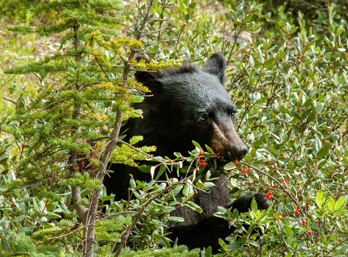
Their study, published in this week’s early online edition of the journal Methods in Ecology and Evolution, might surprise bear ecologists and conservationists who had long assumed that black bears in the Sierra Nevada rely on lots of protein from ants and other insects because their remains are frequently found in bear feces. Instead, the researchers believe that bears likely eat ants for nutrient balance.
Rather than relying on indigestible foods found in bear feces for information about the importance of digestible bear foods, the UC San Diego ecologists looked at the digestible foods that were used to produce bear tissue. They accomplished this by measuring the abundances of carbon and nitrogen isotopes found in different species of plants and animals, and used a statistical approach to relate them to the carbon and nitrogen isotopes measured in bear hair. This allowed the scientists to quantify what the bears ate, then assimilated into their hair.
The scientists also applied the same technique to Norway rats in Alaska’s Aleutian Islands and determined that this invasive species subsisted largely on terrestrial plants and seasonal pulses of marine amphipods, rather than marine birds as had been long assumed.
“Rats tend to dominate the habitats they invade on islands, killing much of the native fauna, especially birds, which is a serious conservation issue,” said Carolyn Kurle, an assistant professor of biology at UC San Diego who conducted the study with Jack Hopkins, a postdoctoral fellow. “Using stable isotopes, we confirmed that marine birds have been extirpated to such levels on the islands where we worked that rats don’t eat them anymore.”
“Both rats and black bears are omnivores with complex diets consisting of both plants and animals,” said Hopkins. “To our knowledge, no study before this has accurately estimated the relative importance of plants and animals to the diets of these omnivore populations.”
Hopkins said he and Kurle found in their study that plants and acorns are black bears’ primary food sources in Yosemite. “We also learned that female bears foraged for high-fat acorns and pine nuts more heavily than males, suggesting that females likely need these seeds for reproduction. This could be a real problem for Sierra black bears in the future if blister rust continues to kill sugar pines and sudden oak death moves in from the coast.”
Besides resolving the issue of what black bears and Norway rats actually use for growth and function, the scientists said a major goal of their study was to demonstrate how the use of stable isotopes derived from animal tissues and their prey could be used to quantify the resource use of other omnivores with complex diets.
“Ecologists currently focus too much attention on measuring the variation of isotope data for consumers and their prey and not enough attention on quantifying the interactions of consumers and their prey using isotope data,” Hopkins explained. “Measuring such interactions and their relative strengths can help us understand the impacts animals have on their environment.”
Over the past two decades, black bears in Yosemite were involved in more than 12,000 reported incidents within the national park, injuring nearly 50 people and causing $3.7 million worth of property damage. In response to these problems, Congress has appropriated over $8 million since 1999 to mitigate human-bear conflicts in Yosemite.
Those efforts appear to be working. In a study published last year in the journal Frontiers in Ecology and the Environment, Hopkins and other scientists measured the stable isotopes of carbon and nitrogen in the hair and bone of Yosemite bears over the past century and found that since 1999, the proportion of human-derived food in bear diets has dramatically declined.
“Yosemite bears currently consume human foods in a similar proportion as they did in the early 1900s,” said Hopkins. “This suggests a notable management achievement in the park, considering that thousands of people visited Yosemite annually in the early 1900s, while about four million people visit each year today.”
Cathy Says:
Hi, Glenn.
Do you feel like a therapist? We’re all asking for your reassurance 🙂
We will be coming to Oahu September 3-5 then to Kauai until September 11. It looks like Ignacio will be gone by the time we arrive but are concerned about Jimena. We’ve rented a spectacular house on a cliff on the north shore for a week and so hope that there is some decent weather so we can get out and about. Changing our plans is not an option and we have trip insurance, but so need this vacation!
If Jimena comes on the path currently predicted, do you see it going over Kauai and when would you anticipate the storm being past the islands.
I’ve become a serial follower! Learning a lot about hurricanes.
One positive thought…the waterfalls will be spectacular!!
Thanks!
~~~ Hi Cathy, one of the serial followers of my website! Since it’s all you ladies writing in about your concerns, I certainly get to practice how to be a gentleman I suppose! I’m getting to exercise another of my areas of expertise, besides weather. One of my college degrees is in Psychology, with the other being in Meteorology and Physical Geography. So I guess I’m being a psychological meteorologist or something!
Anyway, back to weather again, no one knows the track that Jimena will back, not a single person in the world in fact. I’d like to say…not even me…but that’s so untrue! Really, what Jimena will do for anywhere in the islands, including Kauai, is unknown. So, all I can say is, hope for the best, and when shall I arrive for our stay in that cliff side house!? Oh no, I’m going kinda crazy I think with all these inquires into the future…can someone please send me a crystal ball!
Hang in there Cathy, this was a good conversation, it’s good to try and have a little humor in the face of these big hurricanes that have everyone all rattled this summer. Just wait and see, that’s the name of the game, that, and enjoy the heck out of your great vacation there on Kauai!
Aloha, Glenn
CA Says:
Aloha Glenn ,
We are now planning on taking off big island from the islands we visit because of the Ignacio effect . I land in Oahu on 08/30.
Can you let me know if it would be a good plan to still travel to Oahu and Maui given the fact that there is brown water advisory issued and most beaches are closed . I also see that Ignacio and Jemina will have heavy rains at both Maui and Oahu .
I am also now in a fix if I should be cancelling the trip altogether.
Any thoughts ?
Thanks,
CA
~~~ Hello CA, hmmmm, I don’t know anything about a brown water advisory? Where did that come from? You know, it sounds like you have turned the corner somehow. It might not be a bad idea to change your plans, or at least follow the ones that you have already changed. Best of luck, Aloha, Glenn
Tonya Says:
Good morning!
Okay last question I swear (okay probably not… haha) So we fly in Saturday, and we had planned to stay in Haiku a few days to be closer for the drive to see the sunrise, road to hana, etc. I’m studying the forecast of Ignacio every chance I get to try to and make the best guess as to when we need to be settled in for the storm (or rain really). It looks like we’ll have a few sunny days where we can still see the sunrise (hopefully) and do some hana stuff before Ignacio gets close. Would you say we would start to feel the effects of Ignacio late monday? Tuesday? Late Tuesday? Just trying to make some adjustments for our plans but can’t really tell when the rain will get to us. Any best guesses?
{And I will be asking you about the sunrise when the time comes so this is definitely not my last question}
Thank you again so much for your kindness to us all!
~~~Hi again Tonya, yes, you’re getting good, all that studying Ignacio is paying off. Rain and whatever else that this storm/hurricane brings us will likely begin later Monday, and last into later Wednesday. Keep checking back, as things will change, that’s a given with these tropical whirlwinds! Aloha, Glenn
Dee Says:
Hi…we are flying into Kona 8/29 and am quite concerned with the active tropical storms around the Islands. As with the previous poster, we are from AZ and are unfamiliar with hurricanes and what to expect. We were tracking Kilo until it moved away from the islands and are now tracking Ignacio which is currently being tracked toward The Big Island. I also see another storm developing behind Ignacio. My head is spinning! I understand these storms can change course as evidenced by Kilo so there are no guarantees. Also, it seems to early to know what will come to fruition. At this point I am more interested in understanding what the typical rain fall can be expected when a tropical storm moves through; meaning are there typically several days of rain on the front and/or backend of a tropical storm? I was very much looking forward to a sunny, warm tropical paradise vacation! ☀️???? We can change our flight for a small fee so postponing is an option. Thanks for your website I have found it very helpful… As there are so many sites, each containing varying information.
~~~ Hello Dee, as I’ve been saying so much lately, I can understand your concern. This of course is due to the current track for Ignacio pointing very close to the Big Island. I’m looking at the models now, and they continue to show a general trend towards moving Ignacio offshore to the north of the Big Island, not by far though. You mentioned that it would be a small cost to move your trip to some other time, which would be tempting. Personally, I would stick with my trip however, as the storm could bring rainfall, and plenty of it to the Big Island, although likely the Kona coast would be sheltered from some of it. At the same time, the Kona coast could be sheltered from some of the wind too. The potential wet and windy weather wouldn’t last very long, maybe a day at most, as the system moves by. That’s my feedback now. Best of luck, Aloha, Glenn
Liz Cannon Says:
Wondering about the names of these storms heading our way… If they are named in alphabetical order, and K and L have already been used, how are we back on I ?
~~~ Hi Liz, the last two storms began here in the central Pacific, which works off a different list of names…than do the storms that begin in the eastern Pacific. They are the Hawaiian Islands of Kilo and Loke. Jimena started in the eastern Pacific, thus the J name. I hope this helps, Aloha, Glenn