


Air Temperatures – The following maximum temperatures (F) were recorded across the state of Hawaii Thursday…along with the minimums Thursday:
83 – 73 Lihue, Kauai
87 – 73 Honolulu, Oahu
83 – 71 Molokai AP
85 – 70 Kahului, Maui
86 – 72 Kailua Kona
83 – 66 Hilo, Hawaii
Here are the latest 24-hour precipitation totals (inches) for each of the islands, as of Thursday evening:
0.41 Mount Waialeale, Kauai
0.20 Nuuanu Upper, Oahu
0.05 Kamalo, Molokai
0.00 Lanai
0.00 Kahoolawe
0.62 Kula 1, Maui
1.29 Honaunau, Big Island
The following numbers represent the strongest wind gusts (mph)…as of Thursday evening:
18 Poipu, Kauai – NE
27 Kuaokala, Oahu – NNE
25 Molokai – NE
29 Lanai – NE
25 Kahoolawe – NE
24 Kapalua, Maui – NE
27 Kealakomo, Big Island – E
Hawaii’s Mountains – Here’s a link to the live web cam on the summit of near 13,800 foot Mauna Kea on the Big Island of Hawaii. This web cam is available during the daylight hours here in the islands…and when there’s a big moon shining down during the night at times. Plus, during the nights you will be able to see stars, and the sunrise and sunset too… depending upon weather conditions.
Aloha Paragraphs

High cirrus clouds to our southeast…upper level
low pressure system to our northeast – with
Tropical Storm Carlos spinning south of Mexico

Clear to partly cloudy – Looping version of this image

A few showers locally…falling here and there
Here’s the looping radar image for the Hawaiian Islands
~~~ Hawaii Weather Narrative ~~~
The trade winds will become lighter…during this second half of the week. Here’s the latest weather map, showing the Hawaiian Islands, and the rest of the North Pacific Ocean, along with a real-time wind profiler of the central Pacific. We find high pressure systems well to the northwest and north-northeast of the state. As the same time, we have a surface troughs of low pressure to our northeast and northwest. The trade winds will continue, although slow down considerably through the weekend. This is yet another example of the unusual nature of our island weather conditions this spring. Climatology would suggest the trade winds remaining steady here in the tropics…with rarely an interruption as we approach the beginning of the summer season.
Trade wind weather pattern will give way to a more convective pattern…through the weekend. The windward sides will see a few showers…which will get carried our way on the weakening trade wind flow. The atmosphere be a little unstable, although there’s distinct lack of moisture in most areas, thus convective showers should remain rather modest for the most part…with a few exceptions on Maui and the Big Island. As the winds back-off over the next several days, we’ll see afternoon clouds with a few showers developing over our leeward slopes going forward. I’ll be back with more updates on all of the above, I hope you have a great Thursday night wherever you’re spending it! Aloha for now…Glenn.
Here on Maui...early Thursday morning near sunrise, skies are mostly clear, with a few clouds over the nearby ocean, and as usual…capping the West Maui Mountains. The air temperature here in upcountry Kula at 540am was 49.5 degrees, 72 down at the Kahului airport…and 41 degrees atop the Haleakala Crater. It’s a beautiful day, as the last three have been, with a distinct transition from spring to summer…almost summer that is.
– Hi, we’re into the mid-afternoon time frame now, with clear to partly cloudy conditions…along with cloudy areas here and there too. There temperature here at my weather tower in Kula was 77.7 at 320pm, 83 down at the Kahului AP, 84 in Kapalua, 79 out in Hana…and 48 up at the top of the Haleakala Crater.
– It’s now a little after 6pm on this Thursday evening, under clear to partly cloudy skies, with some more compacted cloudy areas over the mountain slopes. These clouds dumped some good rainfall on the slopes of the Haleakala Crater this afternoon, as they did over the leeward slopes of the Big Island too. Here at my place in Kula, there hasn’t been any precipitation.
~~~ Here’s a weather product that I produced for the Pacific Disaster Center (PDC) this morning…covering the Atlantic Ocean, Caribbean Sea, and Gulf of Mexico
~~~ Here’s a weather product that I produced for the PDC this morning…covering the Pacific Ocean, Indian Ocean, and Arabian Sea
El Nino – There’s been lots of news pointing towards El Nino conditions here in the Pacific Ocean lately. As a matter of fact, the El Nino developing in the Pacific this year keeps sending signs reminiscent of the most severe event in 1997-98. The 2015 El Nino, the first since 2010, continues to develop, and models suggest further warming of the tropical Pacific is likely. Sea surface temperatures are forecast to remain above El Nino thresholds for the remainder of the year.
El Nino related weather patterns can make Asia extremely hot as temperatures rise, hurting crops from rice to coffee and palm oil, while greatly limiting the hurricane season in the Atlantic, and bringing cooler, wetter summers to the United States. A sea surface temperature map for the week through June 10th clearly shows the pattern in the Pacific, with a warm tongue extending from the South American coastline, well south of Hawaii…and on across the International Dateline.
Here in the Central Pacific, El Nino typically influences Hawaii in the following ways:
1.) More Active Hurricane Seasons
2.) Four Most Active Seasons have been 1982, 1992, 1994, and 1997 – which have all been El Nino years
3.) Greater Chance of Late Season Hurricane Activity
4.) Drought Conditions during the Winter Months
5.) Numerous High Surf Events during the fall, winter…and early spring months
The Central Pacific Hurricane Center (CPHC) forecasters predict an above normal hurricane season in the Central Pacific Basin this year, and are expecting 5 to 8 tropical cyclones to affect the region. An average season has 4-5 tropical cyclones. That number includes tropical depressions, tropical storms, and hurricanes.
This outlook is based upon the expectation of El Niño continuing and possibly strengthening as the hurricane season progresses. El Niño can decrease the wind shear over the tropical Central Pacific, favoring the development of more and stronger tropical cyclones. El Niño also favors more westward tracking storms from the eastern Pacific into the Central Pacific. This combination typically leads to an above normal Central Pacific hurricane season.
This outlook is a general guide to the overall seasonal hurricane activity in the Central Pacific basin, and does not predict whether or how many…of these systems will affect Hawaii.
Short talks about Climate Change…I found them to be worth listening to
Thomas Friedman, New York Times
The revolution fueled by climate change
Constance Okollet, Community Leader, Uganda
The floods swept my village away
Henry Paulson, 74th U.S. Secretary of the Treasury
Doing nothing is “radical risk taking”
June 13 | Christine Todd Whitman, Former New Jersey Governor, EPA Administrator (2001-03)
We can grow the economy and fight climate change
Gen. Charles E. Jacoby (Ret.), Commander, U.S. North Command
The biggest national security threat you haven’t thought of
Paul Polman, CEO, Unilever
How CEO tackles Unilever’s $300M climate change challenge
Heidi Cullen, Chief Scientist, Climate Central
This is what the perfect risk looks like
Dr. John Holdren, Assistant to the President for Science and Technology
WH science advisor’s surprising view on why climate matters
Cary Fowler, Special Advisor, Global Crop Diversity Trust
Extinction is a process, not an event
Farah Nasif, Syrian Refugee
In Syria, everything changed with the drought
Hal Harvey, CEO, Energy Innovation
Every decade we wait is a thousand years of pain we inflict on future generations
Cleo Paskal, Author, “Global Warring”
The military crisis we’re not prepared for
Major Gen. Munir Muniruzzaman (Ret.), Bangladesh
20% of Bangladesh could be lost to the sea
Ursula Rakova, Community Leader, Papua New Guinea
Our islands are disappearing
William K. Reilly, EPA Administrator (1983-93)
Bush EPA chief’s surprising view on climate change
Rear Adm. David Titley (Ret.), Former Naval Oceanography Operations Command
The nation’s defense is at stake
Bob Inglis, Former U.S. Representative (R–S.C.)
The Republican orthodoxy is changing
Sherri Goodman, U.S. Deputy Undersecretary of Defense (1993-2001)
Climate change is a threat multiplier
Eli Lehrer, President, R Street Institute
Climate change real? Ask the guys who could lose billions
Brig. Gen. Stephen Cheney, USMC (Ret.), CEO, American Security Council
70% of the world’s military is preparing for climate change
Joe Romm, Founding Editor, Climate Progress
We can save the world from hundreds of years of misery
Helene Gayle, President and CEO, CARE USA (2006-15)
What you don’t know about the world’s biggest threat to food security
Nicky Sundt, WWF, Former Wildland Firefighter
There’s no escape route when it comes to climate change
James Woolsey, Director of Central Intelligence (1993-95)
Former CIA director’s surprising take on climate change and national security
George Luber, Associate Director for Climate Change, CDC
Why climate change has CDC scientists worried
World-wide tropical cyclone activity:
>>> Atlantic Ocean: There are no active tropical cyclones
Here’s a satellite image of the Atlantic Ocean
>>> Caribbean Sea: There are no active tropical cyclones
>>> Gulf of Mexico: There are no active tropical cyclones
Here’s a satellite image of the Caribbean Sea…and the Gulf of Mexico
Tropical cyclone formation is not expected during the next 5 days over the areas above
>>> Eastern Pacific:
Tropical Storm 03E (Carlos) remains active about 160 miles south-southwest of Acapulco, Mexico, sustained winds are 60 mph, stationary. Here’s a NHC graphical track map, a looping satellite image…and what the hurricane models are showing for what will become hurricane Carlos during the weekend.
HAZARDS AFFECTING LAND
----------------------
WIND:  Tropical storm conditions are possible within the watch area
by Saturday night.

RAINFALL:  Locally heavy rains could spread over portions of the
southern coast of Mexico, primarily in the states of Oaxaca and
Guerrero, during the next couple of days.

SURF:  Swells associated with Carlos are expected to increase near
the coast of southern Mexico during the next few days.  These swells
could cause life-threatening surf and rip current conditions.
Here’s a wide satellite image that covers the entire area between Mexico, out through the central Pacific…to the International Dateline.
Here’s the link to the National Hurricane Center (NHC)
>>> Central Pacific: There are no active tropical cyclones
No tropical cyclones are expected through the next two days
Here’s a link to the Central Pacific Hurricane Center (CPHC)
>>> Northwest Pacific Ocean: There are no active tropical cyclones
>>> South Pacific Ocean: There are no active tropical cyclones
>>> North and South Indian Oceans: There are no active tropical cyclones
Here’s a link to the Joint Typhoon Warning Center (JTWC)
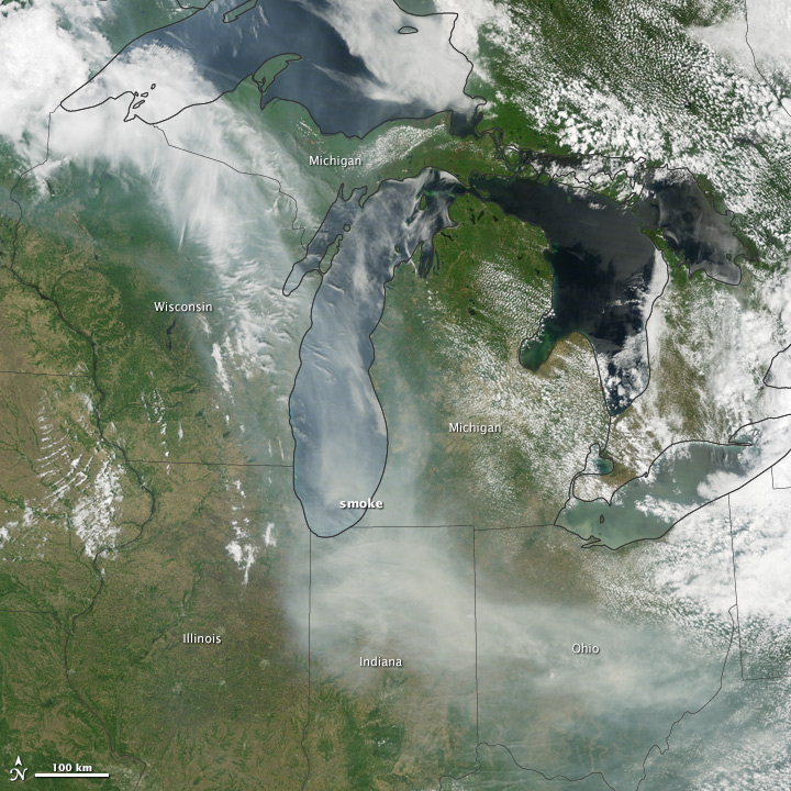
Interesting: Canadian wildfire smoke transported to US – Canada has already had its share of wildfires this season, and the smoke from these wildfires is slowly drifting south over the United States’ Midwest. The drifting smoke can be seen in this Terra satellite image over Lake Michigan, as well as parts of Minnesota, Wisconsin, Indiana and Ohio.
The smoke released by any type of fire (forest, brush, crop, structure, tires, waste or wood burning) is a mixture of particles and chemicals produced by incomplete burning of carbon-containing materials. All smoke contains carbon monoxide, carbon dioxide and particulate matter (PM or soot). Smoke can contain many different chemicals, including aldehydes, acid gases, sulfur dioxide, nitrogen oxides, polycyclic aromatic hydrocarbons (PAHs), benzene, toluene, styrene, metals and dioxins. The type and amount of particles and chemicals in smoke varies depending on what is burning, how much oxygen is available, and the burn temperature. Exposure to any type of smoke should be avoided if possible, but especially by those with respiratory issues, the elderly, and children.