


Air Temperatures – The following maximum temperatures were recorded across the state of Hawaii Sunday afternoon:
Lihue, Kauai – 84
Honolulu airport, Oahu – 86
Molokai airport – 84
Kahului airport, Maui – 87
Kona airport – 86
Hilo airport, Hawaii – 85
Air Temperatures ranged between these warmest and coolest spots near sea level – and on the highest mountain tops around the state…as of 810pm Sunday evening:
Barking Sands, Kauai – 79
Hilo, Hawaii – 73
Haleakala Summit – 45 (near 10,000 feet on Maui)
Mauna Kea Summit – 34 (near 13,800 feet on the Big Island)
Hawaii’s Mountains – Here’s a link to the live web cam on the summit of near 13,800 foot Mauna Kea on the Big Island of Hawaii. This web cam is available during the daylight hours here in the islands…and when there’s a big moon shining down during the night at times. Plus, during the nights you will be able to see stars, and the sunrise and sunset too…depending upon weather conditions. Here's the Haleakala Crater webcam on Maui…although this webcam is not always working correctly.
Tropical Cyclone activity in the eastern and central Pacific – Here’s the latest weather information coming out of the National Hurricane Center, covering the eastern north Pacific. You can find the latest tropical cyclone information for the central north Pacific (where Hawaii is located) by clicking on this link to the Central Pacific Hurricane Center. A satellite image, which shows the entire ocean area between Hawaii and the Mexican coast…can be found here.
Aloha Paragraphs
Gusty trades, off and on showers for the windward
sides into Monday, some elsewhere…then drier
High surf advisory north and some west shores on Kauai
down to Maui…through Monday morning
As this weather map shows, we have a near 1026 millibar high pressure system located to the northeast of the islands. At the same time, we find an early season cold front moving by to the north of the islands. Our local trade winds will be moderately strong Monday and Tuesday…with those occasionally strong gusts.
The following numbers represent the most recent top wind gusts (mph), along with directions as of Sunday evening:
30 Lihue, Kauai – NE
35 Kahuku Trng, Oahu – E
33 Molokai – NE
35 Kahoolawe – NE
35 Kahului, Maui – NE
36 Lanai – NE
36 Puu Mali, Big Island – NE
We can use the following links to see what’s going on in our area of the north central Pacific Ocean. Here's the latest NOAA satellite picture – the latest looping satellite image…and finally the latest looping radar image for the Hawaiian Islands.
Here are the latest 24-hour precipitation totals (inches) for each of the islands as of Sunday evening:
0.76 Kilohana, Kauai
1.34 Moanalua RG, Oahu
0.76 Molokai
0.35 Lanai
0.02 Kahoolawe
2.08 Puu Kukui, Maui
0.75 Kawainui Stream, Big Island
~~ Hawaii Sunset Commentary ~~
Our trade winds will be locally quite gusty Monday and Tuesday. We find a near 1026 millibar high pressure system (weather map), located to the northeast of the islands this evening. As the associated high pressure ridge from this high will be moving northward and strengthening, our winds will remain at least moderately strong. The NWS office in Honolulu is keeping small craft wind advisory flags up in those windiest areas around Maui County and the Big Island. There will be showers falling along our windward sides and elsewhere at times too…into Monday. A fairly typical trade wind weather pattern will prevail through Friday. An approaching cold front by next weekend will turn our winds southeast, bring volcanic haze over parts of the island chain…with afternoon showers in the leeward upcountry areas Saturday and Sunday.
As we look at this satellite image, it shows an area of showery clouds approaching from the east, which will bring moisture our way over the next 24 hours. This area is loosely what's left of a retired tropical cyclone called Lane, which was active in the eastern Pacific earlier this week. It will bring an increase in showers to our windward sides tonight into Monday…with a few stretching over into the leeward sides on the strengthening trade winds. The likely wettest windward side locations will be in Maui County and the Big Island. Drier weather will arrive by Tuesday, lasting through most of the work week. .
Friday evening film: I took the drive down to Kahului to meet some friends for dinner Friday evening. Then afterwards we all went to see a new dramatic film called Arbitrage, starring Richard Gere, Susan Sarandon, Brit Marling, Tim Roth, Laetitia Casta, and Nate Parker…among many others. The synopsis: when we first meet New York hedge-fund magnate Robert Miller on the eve of his 60th birthday, he appears the very portrait of success in American business and family life. But behind the gilded walls of his mansion, Miller is in over his head, desperately trying to complete the sale of his trading empire to a major bank before the depths of his fraud are revealed. Struggling to conceal his duplicity from loyal wife Ellen and brilliant daughter and heir-apparent Brooke, Miller's also balancing an affair with French art-dealer Julie Cote. Just as he's about to unload his troubled empire, an unexpected bloody error forces him to juggle family, business, and crime with the aid of Jimmy Grant, a face from Miller's past. One wrong turn ignites the suspicions of NYPD Detective Michael Bryer, who will stop at nothing in his pursuits. Running on borrowed time, Miller is forced to confront the limits of even his own moral duplicity. Will he make it out before the bubble bursts? ~~~ I've always liked Richard Gere and Susan Sarandon, and the critics are being quite kind to this film for the most part, so I was interested in seeing it. As usual, I enjoyed the film, and was entertained without a doubt. It was fun to stick my head into what its like to be in a very rich lifestyle in New York City, driving around in limousines and such. It was also very interesting to see all the things that can go wrong when you stick your neck out there too far! This particular group of friends that I was with were a little reluctant to give grades, although it seemed like a B grade fit pretty well for most of them, and for me, I would give it a good strong B grade…perhaps edging up very near a B+. Here's the trailer if you're interested in taking a peek.
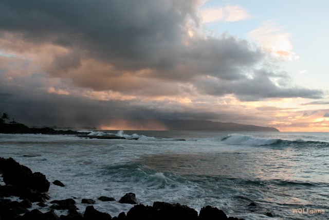
Here in Kula, Maui at 535pm Sunday evening, it was partly to mostly cloudy…with an air temperature of 72.5F degrees. Our trade winds will remain gusty over the next couple of days, likely peaking Monday, and then begin to ease up some by the middle of the new work week. As mentioned above, we'll see an increase in windward showers tonight, which will stretch into Monday as well. Here's a looping radar image so we can keep track of those incoming showers during the next 24 hours. As the winds will be at least moderately strong and gusty, and this area of showers is quite large, the leeward sides will see some of these showers at times too. There won't be any low pressure trough over the islands as this area of showery clouds moves through, so that most of the precipitation will be in the light to moderately heavy range, with a few a bit more generous here and there. This isn't going to be all that big a deal, although it will bring some wetting rains to our windward sides, especially Maui County and the Big Island, and to some lesser extent Oahu and Kauai. I'll be back early Monday morning with your next new weather narrative, I hope you have a great Sunday night wherever you're spending it! Aloha for now…Glenn.
One more thing, since it's fall now, this is the season that I take my vacation, as many of you know. This year is no exception, and I'll be leaving for California on October 4th. I'll spend time in both the northern and southern parts of that state, along with a week long jaunt to the Colorado Rockies this year as well. I'll be back to Hawaii in November, refreshed and ready to start up these weather narratives again then. You will be able to come to this site however, in my absence, for all your current daily forecasts for all the islands, and for news of my travels along the way too. I'll be telling you more about my trip over the next few weeks.
World-wide tropical cyclone activity:
Atlantic Ocean/Caribbean Sea: Tropical storm Nadine remains active, located about 440 miles south of the Azores. Sustained winds were 50 mph, with the center moving west-northwest slowly at 7 mph. Here's the NHC graphical track map, along with the satellite image showing Nadine's position.
Gulf of Mexico: There are no active tropical cyclones
Eastern Pacific Ocean: Hurricane Miriam (13E) remains active in the eastern Pacific…located about 410 miles south-southwest of the southern tip of Baja California. Sustained winds are 120 mph, moving northwest at 12 mph. The NHC forecast this hurricane to weaken back into a tropical storm within 96 hours. Here's the NHC graphical track map, and a satellite image of Miriam.
Central Pacific Ocean: There are no active tropical cyclones
Western Pacific Ocean: Super Typhoon Jelawat (19W) is active in the Philippine Sea, located about 410 NM east of Manila. This tropical cyclone currently has sustained winds of 130 knots, with gusts to near 160 knots! The JTWC shows Jelawat strengthening a bit more, peaking within 12 hours. Here's a graphical track map, along with a satellite image.
Tropical storm Ewiniar (19W) is active in the western Pacific…located about 300 NM south-southwest of Iwo-To, Japan. Sustained winds are 35 knots. The JTWC forecast for this tropical storm shows it remaining a tropical storm through the next four days. Here's the JTWC graphical track map, and a satellite image of Ewiniar.
South Pacific Ocean: There are no active tropical cyclones
North and South Indian Oceans: There are no active tropical cyclones
Jay Says:
Glenn…just curious if there is an explanation foR muggyness down in Kahului today? Early this morning on way to work there was a strange, oval low vRey smooth kind of cloud/fog hovering over the area…and then there was a bad case of flies everywhere at work…very uncomfortable ..!..? ~~~ Hi Jay, there was a low inversion, plus we had a muggy environment, likely caused by the high humidities brought in from the eastern Pacific…as former tropical cyclone Lane came through. As for the flies, you got me there! Aloha, Glenn
B. Hrast Says:
Glenn, Thanks for all you do! Notice we don't show record high temps. for Hawaii any longer? Perhaps its because they show no warming since the nineties.
Most in the fifties? It does not jive with the warming propaganda you offer at the bottom of your daily narratives? Hope you are good. With Respect, Barton~~~Hello Barton, that I don’t show the high temperature records is simply out my own laziness. Propaganda, hmmmm. Aloha, Glenn