March 2009
Monthly Archive
Posted by Glenn
No Comments
March 31 – April 1, 2009
Air Temperatures – The following maximum temperatures were recorded across the state of Hawaii Tuesday afternoon:
Lihue, Kauai – 75
Honolulu, Oahu – 81
Kaneohe, Oahu – 76
Kahului, Maui – 78
Hilo, Hawaii – 75
Kailua-kona – 81
Air Temperatures ranged between these warmest and coolest spots near sea level – and on the highest mountains…at 4 p.m. Tuesday afternoon:
Port Allen, Kauai – 79F
Hilo, Hawaii – 68
Haleakala Crater – 41 (near 10,000 feet on Maui)
Mauna Kea summit – 32 (near 14,000 feet on the Big Island)
Precipitation Totals – The following numbers represent the largest precipitation totals (inches) during the last 24 hours on each of the major islands, as of Tuesday afternoon:
1.57 Mount Waialaele, Kauai
0.60 Mililani, Oahu
0.05 Molokai
0.00 Lanai
0.00 Kahoolawe
1.25 Kaupo Gap, Maui
1.13 Mountain View, Big Island
Weather Chart – Here’s the latest (automatically updated) weather map showing a expansive 1038 millibar high pressure system far to the northeast of the islands. Our trade winds will be locally strong and gusty Wednesday and Thursday…lighter in those more protected places.
Satellite and Radar Images: To view the cloud conditions we have here in Hawaii, please use the following satellite links, starting off with the Infrared Satellite Image of the islands to see all the clouds around the state during the day and night. This next image is one that gives close images of the islands only during the daytime hours, and is referred to as a Close-up visible image. This next image shows a larger view of the Pacific…giving perspective to the wider ranging cloud patterns in the Pacific Ocean. Finally, here’s a looping IR satellite image, making viewable the clouds around the islands 24 hours a day. To help you keep track of where any showers may be around the islands, here’s the latest animated radar image.
Hawaii’s Mountains – Here’s a link to the live webcam on the summit of near 14,000 foot Mauna Kea on the Big Island of Hawaii. The tallest peak on the island of Maui is the Haleakala Crater, which is near 10,000 feet in elevation. These two webcams are available during the daylight hours here in the islands…and when there’s a big moon rising just after sunset for an hour or two! Plus, during the nights and early mornings you will be able to see stars, and the sunrise too…depending upon weather conditions.
Aloha Paragraphs
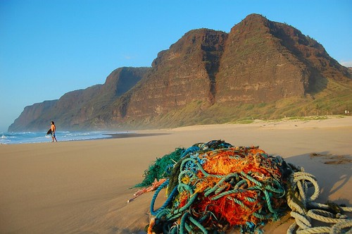
Sandy beach, ropes, nets and stuff…Polihale, Kauai
Photo Credit: Google.com
The gusty trade winds will remain the headline weather news through the next couple of days…at least. An unusually large 1040 millibar high pressure system remains the source of these locally strong and gusty winds Tuesday night…which will be moving slightly closer to Hawaii Wednesday. These winds are strong enough to keep small craft wind advisories active over all of Hawaii’s channel and coastal waters. A high surf advisory for the east facing shores is active, due to the rough surf pounding those beaches. The computer models suggest that these trade winds will blow through the rest of this week into next week.
As the trade winds become even more blustery, we should see even more showers being carried our way…generally along the windward sides. These showers will be moving along rapidly, under the influence of the strong and gusty winds. This will keep the showers from being too overbearing in most areas, falling in an off and on…although more on than off at times! Meanwhile, the high cirrus clouds located to the west and southwest of our islands, have made another surge in our direction Tuesday. Looking at this satellite image, we can see them moving over the 50th state once again…which will filter and dim our Hawaiian sunshine temporarily. As we know, they are famous for sometimes bringing us colorful sunrise and sunset colors.
Let’s keep track of the trade wind gusts again Tuesday, as they will continue to dominate our Hawaiian Island weather picture. These trade winds were still quite gusty at around 4pm Tuesday afternoon, with these numbers (mph) the strongest on each of the individual islands:
Kauai: 32
Oahu: 42
Molokai: 35
Lanai: 35
Kahoolawe: 47
Maui: 42
Big Island: 37
The winds late Tuesday afternoon remain gusty, especially around Maui County and Oahu…where 40+ mph gusts were blowing. These strong trade winds will last for another couple of hours, before settling down some overnight, at least they usually do…only to flare up again on Wednesday.
It’s early Tuesday evening here in Kihei, Maui, as I begin typing out this last section. Not much has changed since early this morning, in terms of the strong and gusty trade winds that is. They’re still kicking up their heels, and should gain a little more velocity on Wednesday. Besides the winds, which I covered quite a bit above, we have generally cloudy skies out there late in the day. This cloudiness isn’t situated in the lower levels of the atmosphere, but rather up high, where those cirrus clouds are being carried along in the sub-tropical jet stream. These will definitely give us a good reason to keep an eye on our skies around sunset time…and then again early Wednesday when the sun comes up again. I notice that there are some middle level clouds mixed into this overcast, which can sometimes get in the way of our most colorful sunset and sunrise events.
~~~ What else? Well, lets see, oh yeah, there was an increase in our trade wind born showers, along our windward sides Tuesday, which will remain wet. The trade winds are coming at us from more or less directly east. This will account for a couple of things, the first is relatively warm air, or what we could call seasonable during the last day of March, going into the first day of April. The second point I want to make is that whatever clouds get carried into our area, will deposit their moisture generally along our north and east facing windward coasts and slopes. That doesn’t mean that the south and west facing leeward beaches won’t see a couple of drops falling, or even a light shower, carried over that way on the fresh trade wind flow…only on the smaller islands from to Molokai. Since we’re talking about precipitation, here’s a looping radar image for the islands.
~~~ I’m just about ready to hit the road, for the 40 or so minute drive back upcountry to Kula. Looking out the window here in Kihei, there’s no doubt about it, it’s cloudy out there. Not a heavy duty rainfall inducing overcast, but just a pretty good high cloud overcast. I may sound quite chipper writing these words, but I’m actually a little down in the mouth, as I got some news about my Dad’s health, that was not uplifting. I’m hoping for the best, and apparently this particular condition is slow growing, and many men can live a long time with such a problem. My Dad, Ed James, is a real trooper, and has got a good strong constitution otherwise. At any rate, setting that aside for the time being, I’ll look forward to catching up with you early Wednesday morning, when I’ll be back online with your next new weather narrative from paradise. I hope you have a great Tuesday night, and if you’re here in the islands, don’t forget to check out the possible nice sunset this evening, and at least lift your head off the pillow Wednesday morning for a peek at that beautiful pink and orange sunrise! Aloha for now…Glenn.
Interesting: Organizers of the 2010 Olympic Winter Games said on Monday they are confident they can find sponsors to help with the estimated $3.6 million cost of keeping the event from adding to global warming. The Winter Games in Vancouver are expected to create about 300,000 tons of carbon emissions, including those from airplanes bringing thousands of athletes and spectators to the western Canadian city.
The Vancouver Organizing Committee said it is in talks with carbon offset management companies it hopes will help sponsor the cost of buying credits, which it said is running between C$10 and C$20 a ton. But the search for sponsors also comes as VANOC and other international sporting event groups are struggling to line up sponsors amid the global economic crisis. We’re very confident we will be able to get partners on this," VANOC chief executive John Furlong told reporters outside an international conference in Vancouver on the environmental costs of major sports events.
Interesting2: The Nature Conservancy has sold 92,000 acres of forest in the Adirondacks to a Danish pension fund as part of a long-term strategy to protect the land from development. The pension fund, ATP, paid $32.8 million for the acreage. The fund will benefit from tax credits related to a planned New York State conservation easement on the land that prohibits development but allows recreation and logging under strict sustainable forestry standards.
RMK Timberland Group will manage the land for the pension fund. Officials at the conservancy, an international nonprofit environmental group, said the transaction struck a balance between protection of wild lands and the region’s economic interests.
Not only will it maintain environmentally responsible logging operations, they said, but it will create the opportunity for moneymaking recreational uses in areas that have been closed to the public. "This is an extraordinary investment in the Adirondack economy by a world leader pension fund, and an affirmation of the viability of green investment in timber," said Michael T. Carr, executive director of the Adirondack chapter of the Nature Conservancy.
The land is part of 161,000 acres in the Adirondacks, including mountain peaks, lakes, ponds, rivers, streams and a commercial forest, that the Nature Conservancy bought in 2007 from the Finch Paper company for $110 million to prevent it from being subdivided and developed by builders of houses and resorts.
Interesting3: Still reeling from the national salmonella outbreak in peanuts, the Food and Drug Administration said central California-based Setton Farms, the nation’s second-largest pistachio processor, was voluntarily recalling all of its 2008 crop — more than 1 million pounds of nuts. "Our advice to consumers is that they avoid eating pistachio products, and that they hold onto those products," said Dr. David Acheson, assistant commissioner for food safety. "The number of products that are going to be recalled over the coming days will grow, simply because these pistachio nuts have then been repackaged into consumer-level containers."
Two people called the FDA complaining of gastrointestinal illness that could be associated with the nuts, but the link hasn’t been confirmed, Acheson said. Still, the plant decided to shut down late last week, officials said. The recalled nuts represent a small fraction of the 60 million pounds of pistachios that the company’s plant can process each year and an even smaller portion of the 278 million pounds produced in the state in the 2008 season, according to the Fresno-based Administrative Committee for Pistachios.
Interesting4: Airlines will reduce their carbon emissions by nearly 8 percent this year as they slash the number of flights they operate in line with a drop in both cargo and passenger demand, executives said on Tuesday. The airline sector was once seen as a driving force behind global warming, which is linked to the burning of fossil fuels such as oil, but the world financial crisis has taken the heat off the industry, which is keen to save fuel to reduce costs.
About 6 percent of the forecast carbon cut will come as a result of carriers flying fewer planes in 2009, and a further 1.8 percent reflects steps to improve energy efficiency, the International Air Transport Association (IATA) said. IATA Director-General Giovanni Bisignani also reported that leading carriers have run successful tests with bio-fuels made from plants, raising the possibility that algae and other crops could be certified to power flights as early as next year. Continental Airlines, Japan Airlines, Air New Zealand and Virgin have all had positive results with bio-jet fuels made from algae, the non-food crop jatropha, and camelina, a type of flax.
Interesting5: The United States has applied to the International Maritime Organization to create a 230-mile emissions control zone around the nation’s coastline, Environmental Protection Agency Administrator Lisa Jackson said Monday. Jackson wants to limit emissions along the nation’s coastline and within its seaports, just as the agency does along highways, with tougher pollution standards on large commercial ships. The move is intended to ensure the shipping industry does its part to improve the air quality of major seaport communities.
Ships moving through the zone would be subject to the tougher emissions standards. "This is an important and long overdue step to protect the air and water along our shores," Jackson said, speaking in front of a row of cranes at a press conference in Port Newark. Jackson estimated that 40 of the 100 largest U.S. ports are located in metropolitan areas that fail to meet federal air quality standards. One of them is the Port Newark facility, which is part of the Port of New York and New Jersey — the East Coast’s largest port complex.
Interesting6: President Barack Obama signed legislation Monday setting aside more than 2 million acres as protected wilderness. Obama called the new law among the most important in decades "to protect, preserve and pass down our nation’s most treasured landscapes to future generations." At a White House ceremony, Obama said the law guarantees that Americans "will not take our forests, rivers, oceans, national parts, monuments, and wilderness areas for granted, but rather we will set them aside and guard their sanctity for everyone to share.
That’s something all Americans can support." The law — a collection of nearly 170 separate measures — represents one of the largest expansions of wilderness protection in a quarter-century. It confers the government’s highest level of protection on land in nine states. Land protected under the 1,200-page law ranges from California’s Sierra Nevada and Oregon’s Mount Hood to Rocky Mountain National Park in Colorado and parts of the Jefferson National Forest in Virginia.
Interesting7: The largest mass extinction in the history of the earth could have been triggered off by giant salt lakes, whose emissions of halogenated gases changed the atmospheric composition so dramatically that vegetation was irretrievably damaged. At least that is what an international team of scientists has reported in the most recent edition of the Proceedings of the Russian Academy of Sciences (Dokladi Earth Sciences). At the Permian/Triassic boundary, 250 million years ago, about 90 percent of the animal and plant species ashore became extinct. Previously it was thought that volcanic eruptions, the impacts of asteroids, or methane hydrate were instigating causes.
The new theory is based on a comparison with today’s biochemical and atmospheric chemical processes. "Our calculations show that airborne pollutants from giant salt lakes like the Zechstein Sea must have had catastrophic effects at that time", states co-author Dr. Ludwig Weißflog from the Helmholtz-Center for Environmental Research (UFZ). Forecasts predict an increase in the surface areas of deserts and salt lakes due to climate change. That is why the researchers expect that the effects of these halogenated gases will equally increase.
The team of researchers from Russia, Austria, South Africa and Germany investigated whether a process that has been taking place since primordial times on earth could have led to global mass extinctions, particularly at the end of the Permian. The starting point for this theory was their discovery in the south of Russia and South Africa that microbial processes in present-day salt lakes naturally produce and emit highly volatile halocarbons such as chloroform, trichloroethene, and tetrachloroethene.
They transcribed these findings to the Zechstein Sea, which about 250 million years ago in the Permian Age, was situated about where present day Central Europe is. The Zechstein Sea with a total surface area of around 600.000 km2 was almost as large as France is today.
The hyper saline flat sea at that time was exposed to a predominantly dry continental desert climate and intensive solar radiation – like today’s salt seas. "Consequently, we assume that the climatic, geo-chemical and microbial conditions in the area of the Zechstein Sea were comparable with those of the present day salt seas that we investigated," Weißflog said.
Posted by Glenn
No Comments
March 30-31, 2009
Air Temperatures – The following maximum temperatures were recorded across the state of Hawaii Monday afternoon:
Lihue, Kauai – 75
Honolulu, Oahu – 82
Kaneohe, Oahu – 77
Kahului, Maui – 79
Hilo, Hawaii – 77
Kailua-kona – 80
Air Temperatures ranged between these warmest and coolest spots near sea level – and on the highest mountains…at 4 p.m. Monday afternoon:
Honolulu, Oahu – 80F
Lihue, Kauai – 73
Haleakala Crater – missing (near 10,000 feet on Maui)
Mauna Kea summit – 34 (near 14,000 feet on the Big Island)
Precipitation Totals – The following numbers represent the largest precipitation totals (inches) during the last 24 hours on each of the major islands, as of Monday afternoon:
0.83 Mount Waialaele, Kauai
0.84 South Fork Kaukonahua, Oahu
0.02 Molokai
0.00 Lanai
0.01 Kahoolawe
3.55 Puu Kukui, Maui
0.77 Mountain View, Big Island
Weather Chart – Here’s the latest (automatically updated) weather map showing a strong 1037 millibar high pressure system far to the northeast of the islands. Our trade winds will be moderate to locally strong and gusty Tuesday and Wednesday…lighter in those more protected places.
Satellite and Radar Images: To view the cloud conditions we have here in Hawaii, please use the following satellite links, starting off with the Infrared Satellite Image of the islands to see all the clouds around the state during the day and night. This next image is one that gives close images of the islands only during the daytime hours, and is referred to as a Close-up visible image. This next image shows a larger view of the Pacific…giving perspective to the wider ranging cloud patterns in the Pacific Ocean. Finally, here’s a looping IR satellite image, making viewable the clouds around the islands 24 hours a day. To help you keep track of where any showers may be around the islands, here’s the latest animated radar image.
Hawaii’s Mountains – Here’s a link to the live webcam on the summit of near 14,000 foot Mauna Kea on the Big Island of Hawaii. The tallest peak on the island of Maui is the Haleakala Crater, which is near 10,000 feet in elevation. These two webcams are available during the daylight hours here in the islands…and when there’s a big moon rising just after sunset for an hour or two! Plus, during the nights and early mornings you will be able to see stars, and the sunrise too…depending upon weather conditions.
Aloha Paragraphs
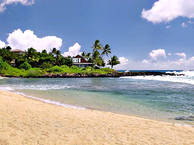
The kind of place that we’d all like to spend some time!
Photo Credit: Google.com
Strong and gusty trade winds will be the name of the game this week! A large 1037 millibar high pressure system remains the source of these locally strong and gusty winds Monday night. These winds are strong enough to keep small craft wind advisories active over all of Hawaii’s channel and coastal waters, from Kauai down through the Big Island. The NWS office in Honolulu is hinting that we may see gale warnings going up in those windiest channel waters by mid-week. A wind advisory went up over the Haleakala Crater summit on Maui Monday…where 25-40 mph winds are occurring.
It’s pretty dry out there right now, although as the trade winds become even more blustery, we should start to see more showers being carried our way…generally along the windward sides. The high clouds, which have dimmed and filtered our sunshine too much lately, are now located to the southwest and southeast of the islands. Looking at this satellite image, we can see them sort of looming down to the left hand side of all our islands. As the winds are locally quite strong, it would be best to hit the beaches during the mornings, as the winds are apt to be strongest during the afteroon hours.
Let’s keep track of the trade wind gusts again Monday, as they will continue to dominate our Hawaiian Island weather picture. These trade winds were still quite gusty at around 4pm Monday afternoon, with these numbers (mph) the strongest on each of the individual islands:
Kauai: 33
Oahu: 39
Molokai: 38
Lanai: 40
Kahoolawe: 48
Maui: 42
Big Island: 42
We find all the islands having gusts well up into the 30 mph range late Monday afternoon…with the one gust up up to 48 mph on the small island of Kahoolawe! If the winds become even more gusty later this week, which is expected, they will be topping 50 mph in those windiest areas. It may become necessary to secure loose objects in those most gusty areas on some of the islands by mid-week.
It’s early Monday evening here in Kihei, Maui, as I begin typing out this last section. Looking at the very latest top gust around the state, at around 5pm, we find a 46 mph reading at Kahoolawe, that small island offshore from south Maui. It wouldn’t surprise me one bit to have winds gusting up to near 55 mph at some point by Wednesday or Thursday. Otherwise, looking out the windows here in Kihei, before I take the drive back upcountry to Kula, it’s sunny, really sunny! It’s not that windy along the south coast of Maui, as the trade winds are so easterly in direction. At the moment, they are blowing what I would estimate to be near 5-15 mph here in Kihei. Places that are more exposed to the easterlies however, are finding much stronger winds. Kahului airport at the same time was experiencing 35 mph gusts, while Maalaea Bay was checking in with 40 mph. Kapalua and Napili are feeling the winds too, where they are blowing close to 35 mph in gusts. I just called my neighbors in Kula, and they said the wind was essentially calm. It’s all about the direction of the winds here in Hawaii! ~~~ I’m just about ready to jump in the car, and as soon as I get home, I’ll jump into my tennis shoes, and walking clothes. I can’t wait to get out on the road for my evening walk, it always feels so good! I hope you have a great Monday night, and that wish comes hand in hand with an invitation to join me here again on Tuesday, same time and same station, so to speak! Aloha for now…Glenn.
Interesting: Juan Lopez reads meters with one eye and looks for snakes with the other. Lopez is a member of the "Python Patrol," a team of utility workers, wildlife officials, park rangers and police trying to keep Burmese pythons from gaining a foothold in the Florida Keys. Officials say the pythons — which can grow to 20 feet long and eat large animals whole — are being ditched by pet owners in the Florida Everglades, threatening the region’s endangered species and its ecosystem.
"Right now, we have our fingers crossed that they haven’t come this far yet, but if they do, we are prepared," Lopez said.Burmese Pythons are rarely seen in the middle Florida Keys, where Lopez works. The Nature Conservancy wants to keep it that way The Python Patrol program was started by Alison Higgins, the Nature Conservancy’s Florida Keys conservation manager.
She describes it as an "early detection, rapid response" program made up of professionals who work outside. Eight Burmese pythons have been found in the Keys. "If we can keep them from spreading and breeding, then we’re that much more ahead of the problem," Higgins said. Utility workers, wildlife officials and police officers recently attended a three-hour class about capturing the enormously large snakes.
Lt. Jeffrey L. Fobb of the Miami-Dade Fire Rescue Venom Response Unit taught the participants how to capture pythons. "There’s no immutable laws of snake catching. It’s what works," Fobb said as he demonstrated catching a snake with hooks, bags, blankets and his hands. "We’re doing it in the Florida Keys because we have a lot to protect," Higgins said.
"The Burmese pythons that are coming out of the Everglades are eating a lot of our endangered species and other creatures, and we want to make sure they don’t breed here." Where the snakes are breeding is just north of the Keys in Everglades National Park. An estimated 30,000 Burmese pythons live in the park. The Everglades, known as the "River of Grass," is a vast area with a climate perfect for these pythons to hide and breed.
And breed they do: The largest clutches of eggs found in the Everglades have numbered up to 83. The snakes grow like they’re on steroids. With a life span of 30 years, these pythons can weigh as much as 200 pounds. And the larger the snake, the bigger the prey. Biologists have found endangered wood rats, birds, bobcats and other animals in their stomachs.
Two 5-foot-long alligators were found in the stomachs of Burmese pythons that were caught and necropsied, officials say. Officials also say Burmese pythons can travel 1.6 miles a day by land, and they can swim to reach areas outside the Everglades. This non-venomous species was brought into the United States from Southeast Asia. Everglades National Park spokeswoman Linda Friar says biologists believe that well-intended pet owners are to blame for their introduction into the Everglades.
Interesting2: The Anchorage, Alaska, airport reopened Sunday, a day after it was closed when a volcano in Alaska erupted and shot ash some 45,000 feet in the air. Ash from the Mount Redoubt volcano fell around the city, Alaska’s largest, resulting in the closure of Ted Stevens Anchorage International Airport, the Federal Aviation Administration said. Only a trace amount of the ash reached the airport grounds, airport spokesman Jeremy Lindseth said, but it was enough to affect operations.
The airport reopened about 2 p.m. (6 p.m. ET) Sunday, according to the airport’s operations office. Saturday’s eruption occurred at about 1:30 p.m. (5:30 p.m. ET), the U.S. Geological Survey told CNN. Mount Redoubt erupted three times on Friday, at times shooting ash 51,000 feet into the air. There were no eruptions Sunday, the Alaska Volcano Observatory said, but seismic activity continued and the observatory kept its alert level at red, its highest possible designation.
That level indicates that an eruption is under way or imminent and that the eruption will produce a "significant emission of volcanic ash into the atmosphere." Saturday’s eruptions were the latest in a series that began March 22. Friday’s volcano activity prompted Alaska Airlines to limit flights to and from Anchorage, according to the airline’s Web site.
It canceled all its Thursday flights to and from Anchorage after an eruption earlier in the day sent an ash cloud 65,000 feet high. iReport.com: Send photos, videos of the volcanic ash. The airline said on its Web site Sunday that flights "may experience delays or cancellations due to the eruption of Mount Redoubt."
Interesting3: Residents across the Southeast weren’t singing when they called emergency and weather officials to report "great balls of fire" in the night sky. Residents in Maryland, North Carolina and Virginia reported brilliant, streaking lights followed by a thunderous sound about 9:45 p.m. Sunday. National Weather Service officials say they have no explanation for the sky lighting up in shades of yellow, white, orange and blue. The unusual sky prompted hundreds of calls, with some saying they saw "great balls of fire." The weather service says no damage has been reported.
Interesting4: From the Great Pyramids to the Acropolis, and the London Eye to the Las Vegas strip, nearly 4,000 cities and towns in 88 countries joined in the World Wildlife Fund-sponsored event, a time zone-by-time zone plan to dim non-essential lights between 8.30pm and 9.30pm. Dr Richard Dixon of WWF Scotland said: "Earth Hour was the biggest ever show of support for action on climate change. "Millions of people showed world leaders they want strong action." Interest has spiked ahead of planned negotiations on a new global warming treaty in Copenhagen this December.
Organisers are calling Earth Hour a "global election", with switching off the lights seen as a vote for the Earth and failure to do so a vote for global warming. Earth Hour executive director Andy Ridley said: "Earth Hour has always been a positive campaign. It’s always around street parties, not street protests. It’s the idea of hope, not despair. And I think that’s something that’s been incredibly important this year because there is so much despair around.
"The primary reason we do it is because we want people to think, even if it is for an hour, what they can do to lower their carbon footprint, and ideally take that beyond the hour." Landmarks including the London Eye, the Gherkin and the BT Tower also took part last night, although activists warned companies in the financial sector they would have shut down electricity supplies themselves unless the lights went out.
Earlier yesterday, the Chatham Islands, a group of small islands 500 miles east of New Zealand, officially kicked off Earth Hour by switching off its diesel generators. Then Auckland’s Sky Tower, the tallest manmade structure in New Zealand, blinked off. Forty-four New Zealand towns and cities participated in the event, and more than 60,000 people showed up for an Earth Hour-themed hot air ballooning festival in Hamilton.
At Scott Base in Antarctica, New Zealand’s 26-member winter team resorted to minimum safety lighting and switched off appliances. In Asia, lights at landmarks in China, Singapore, Thailand and the Philippines also dimmed as people celebrated with candlelit picnics and concerts. Buildings in Singapore’s business district went dark along with major landmarks, such as the Singapore Flyer.
China, which has overtaken the US as the world’s top greenhouse gas emitter, was participating for the first time, with Beijing turning off the lights at its Bird’s Nest Stadium and Water Cube, the two most prominent venues for the Olympics, according to the WWF.
Interesting5: The warning has been made by Birmingham and Warwick university scientists, who say disinfectants and other products washed into sewers and rivers are triggering the growth of drug-resistant microbes. Soil samples from many areas have been found to contain high levels of bacteria with antibiotic-resistant genes, the scientists have discovered – raising fears that these may have already been picked up by humans.
"Every year, the nation produces 1.5m tons of sewage sludge and most of that is spread on farmland," said Dr William Gaze of Warwick University. That sludge contains antibiotic-resistant bacteria whose growth is triggered by chemicals in detergents, he explained. "In addition, we pump 11bn liters of water from houses and factories into our rivers and estuaries every day, and these are also spreading resistance."
The study is important because it suggests that the problem of drug resistance is not merely the result of the over-prescription of antibiotics or poor hygiene standards in hospitals. However, the team stressed the emergence of the most deadly superbugs – such as MRSA that has caused thousands of deaths in hospitals – is not linked to the use of disinfectants.
"Our research shows drug resistance is not confined to hospitals, but is out in the community. It is spreading and all the time it is eroding our ability to control infections. It is extremely worrying," said Professor Liz Wellington, also of Warwick University.
Interesting6: The global economic crisis is jeopardizing efforts to help the world’s growing number of slum dwellers, U.N. Secretary-General Ban Ki-moon said Monday. The U.N. housing agency UN-Habitat, which is hosting a major meeting this week in the Kenyan capital, says the number of slum dwellers in the world could triple to 3 billion by 2050 if left unchecked. Delegates from dozens of nations, NGOs and grassroots groups are gathered in Nairobi to discuss how to allocate resources to the problem over the next two years in the face of the worst financial downturn since the Great Depression.
"The persistence of urban poverty is largely the result of weak urban economies and finance," Ban said in a speech read to the meeting on his behalf. "The current global financial crisis and credit crunch only exacerbate this situation. There is a risk that our efforts … to address the shelter crisis will be rolled back."
Slums are most prevalent in sub-Saharan Africa, where 62 percent of the urban population have inadequate shelter, followed by south Asia with 43 percent and east Asia at 37 percent, Moon said. UN-Habitat boss Anna Tibaijuka said the U.S. sub-prime housing crisis was a "watershed" that put affordable housing on the agenda as an economic, rather than social, issue.
She said public-private partnerships were essential to providing housing solutions for the world’s poorest people, and could also help stimulate the economy. "Economists are emphasizing the economic importance of housing and urban infrastructure as part of the productive sector which will generate employment," she told reporters.
Interesting7: Ants don’t march in predictable patterns to search for crumbs, as you might have thought by watching them. Instead, new research suggests they roam randomly. This is not a matter of ant versus human intelligence, because a seemingly blind search can still make sense in both practical and mathematical terms. "The beauty of a mathematical random walk is that it eventually visits all points in space if you walk long enough — and it always returns to its starting point," said William Baxter, an experimental physicist at Penn State Erie, The Behrend College.
Of course, Baxter notes, you might have to walk a long time to get back to the start. But a person who tries a search pattern, such as sweeping back and forth, can run into more trouble with unexpected obstacles. Baxter’s research stands out from others’ by using a controlled environment and a single ant, as opposed to studying foraging ants in the wild.
Tracking single ants allowed him to see how a single ant decides to search an area that is free of food, chemical clues or obstacles. Each small ant walked down a string from its colony to the study area, where the ants normally expect to find an area with food. However, Baxter and his colleagues removed the food while conducting the experiment.
The ant search patterns often crisscrossed previous paths, but none of the ants ever intentionally retraced their steps. A few backed up for a few millimeters on occasion, but only rarely. A next step could involve repeating the experiment with pairs of ants to see if a foraging partner changes the search pattern.
"Will the mathematical model change? I have no idea," Baxter told LiveScience. "But biologists have known for years that groups of ants can accomplish tasks that single ants cannot." Ants are known to communicate chemically and leave trails for others, which points to their cooperative intelligence and socially sophisticated ant societies. So for finding crumbs, two pair of antennae may turn out better than one – or the ant pairs might wander just as randomly as before.
Posted by Glenn
No Comments
March 29-30, 2009
Air Temperatures – The following maximum temperatures were recorded across the state of Hawaii Sunday afternoon:
Lihue, Kauai – 75
Honolulu, Oahu – 81
Kaneohe, Oahu – 75
Kahului, Maui – 79
Hilo, Hawaii – 76
Kailua-kona – 84
Air Temperatures ranged between these warmest and coolest spots near sea level – and on the highest mountains…at 2 p.m. Sunday afternoon:
Kailua-kona – 81F
Princeville, Kauai – 73
Haleakala Crater – missing (near 10,000 feet on Maui)
Mauna Kea summit – 37 (near 14,000 feet on the Big Island)
Precipitation Totals – The following numbers represent the largest precipitation totals (inches) during the last 24 hours on each of the major islands, as of Sunday afternoon:
0.71 Mount Waialaele, Kauai
0.25 Wheeler Field, Oahu
0.00 Molokai
0.00 Lanai
0.00 Kahoolawe
1.20 Puu Kukui, Maui
0.70 Piihonua, Big Island
Weather Chart – Here’s the latest (automatically updated) weather map showing a strong 1034 millibar high pressure system far to the northeast of the islands. Our trade winds will be moderate to locally strong and gusty Monday and Tuesday…lighter in those more protected places.
Satellite and Radar Images: To view the cloud conditions we have here in Hawaii, please use the following satellite links, starting off with the Infrared Satellite Image of the islands to see all the clouds around the state during the day and night. This next image is one that gives close images of the islands only during the daytime hours, and is referred to as a Close-up visible image. This next image shows a larger view of the Pacific…giving perspective to the wider ranging cloud patterns in the Pacific Ocean. Finally, here’s a looping IR satellite image, making viewable the clouds around the islands 24 hours a day. To help you keep track of where any showers may be around the islands, here’s the latest animated radar image.
Hawaii’s Mountains – Here’s a link to the live webcam on the summit of near 14,000 foot Mauna Kea on the Big Island of Hawaii. The tallest peak on the island of Maui is the Haleakala Crater, which is near 10,000 feet in elevation. These two webcams are available during the daylight hours here in the islands…and when there’s a big moon rising just after sunset for an hour or two! Plus, during the nights and early mornings you will be able to see stars, and the sunrise too…depending upon weather conditions.
Aloha Paragraphs

Maui, No Ka Oi…as the saying goes ("the best")
Photo Credit: Google.com
Moderately strong trade winds will continue, which will increase in strength as we move into the new week ahead. A large 1035 millibar high pressure system remains the source of these strong and gusty winds Sunday. These winds are strong enough to keep small craft wind advisories active across the Hawaiian channel waters, from Kauai down through the Big Island…as well as a few of the windier coastal waters. There is the expectation that these trade winds will increase in strength Monday through mid-week…necessitating localized wind advisories in those typically most windy areas.
There are some showers along the windward sides Sunday afternoon, with an increase on tap during the first half of the new work week. Meanwhile, the cirrus clouds, being carried our way on the upper winds aloft, will remain a part of our Hawaiian Island weather picture, as we move through the next couple of days. Looking at this satellite image, we see this latest area of cirrus cloudiness covering much of the state. This looping satellite image shows the high clouds (brighter clouds) arriving from the southwest, while the lower level clouds (dull gray), being carried by the trade winds…coming in from the east.
Let’s keep track of the trade wind gusts again today, as they will continue to dominate our Hawaiian Island weather picture Sunday afternoon. These trade winds were still quite gusty at around 3pm, with these numbers (mph) the strongest on each of the individual islands:
Kauai: 35
Oahu: 39
Molokai: 33
Lanai: 37
Kahoolawe: 40
Maui: 45
Big Island: 37
Looking ahead into the next 3-4 days, it appears that the trade winds will do nothing but remain strong, or get stronger. I will keep providing you these top gusts periodically…as I find it very interesting as well.
It’s mid-afternoon Sunday here in Kula, Maui, as I begin typing out this last paragraph. I’m going to take off the rest of the day, or at least I think I am. My Mom sometimes remarks that "you work too much Glenn." So, I’m going to follow her lead, and just take the rest of the day off from updating this website. The truth is that I don’t even feel like updating this popular website as work! By the way, the reason that I refer to my own website as popular, is by referring to what the Google team tells me. They say that so far this month, there have been 411,328 unique page impressions on this site, which quite honestly impresses me! This number is working towards half a million looks at all my pages…by you! The number of times that you have clicked on my google ads has been, as of 3pm Sunday afternoon, 6,872 times…wow! I would like to take this moment to thank you for your readership, it so makes it worth while to continue my daily updates! ~~~ If I really don’t come back online later this evening, than I will absolutely return early Monday morning with your next new weather narrative from paradise. I hope you have a wonderful Sunday evening/night until we meet again here! By the way, rest assured, that if you live here in the islands, we will be viewing the colorful sunset together this evening. Aloha for now…Glenn
Interesting: Honda Motor Company on Tuesday set the base price for its Insight hybrid at 10 percent below the market-leading Prius hybrid made by larger rival Toyota Motor Corp. Honda said the 2010 Insight would start at $19,800, making it the first hybrid to sell in the U.S. market below $20,000. The 2009 model Prius starts at $22,000. Honda has positioned the five-door Insight as an economical alternative to the Prius, which has come to dominate the hybrid market with its distinctive styling and fuel economy. "I think what they are looking to do is to bring a new buyer to the marketplace for hybrids, people who are interested but maybe couldn’t afford the Prius," said Jack Nerad, analyst at Kelley Blue Book, a leading vehicle pricing guide.
Interesting2: Farmers of the future will have to use cattle and sheep that belch less methane, crops that emit far less planet-warming nitrous oxide and become experts in reporting their greenhouse gas emissions to the government. Agriculture is a major source of greenhouse gases, and globally that share will rise as demand for food from growing human populations also increases, scientist Richard John Eckard of the University of Melbourne said on Thursday.
But farmers are facing a near-impossible challenge: feeding the world while trying to trim emissions and adapt to greater extremes of droughts and floods because of global warming, he said. In coming years, farmers will have to monitor and report emissions as more nations move toward emissions trading.
Interesting3: Our brain extracts important information for face recognition principally from the eyes, and secondly from the mouth and nose, according to a new study from a researcher at the University of Barcelona. This result was obtained by analyzing several hundred face images in a way similar to that of the brain. Imagine a photograph showing your friend’s face. Although you might think that every single detail in his face matters to recognize him, numerous experiments have shown that the brain prefers a rather coarse resolution instead, irrespective of the distance at which a face is seen.
Until now, the reason for this was unclear. By analyzing 868 male and 868 female face images, the new study may explain why. The results indicate that the most useful information is obtained from the images if their size is around 30 x 30 pixels. Moreover, images of eyes give the least "noisy" result (meaning that they convey more reliable information to the brain compared to images of the mouth and nose), suggesting that face recognition mechanisms in the brain are specialized to the eyes.
Interesting4: A new study published in the journal Soil Use and Management attempts for the first time to measure the extent and severity of land degradation across the globe and concludes that 24% of the land area is degrading – often in very productive areas. Land degradation – the decline in the quality of soil, water and vegetation – is of profound importance but until now there have been no consistent global data by which to assess its extent and severity.
For nearly thirty years the world has depended on the Global Assessment of Soil Degradation (GLASOD) based on the subjective judgement of soil scientists who knew the conditions in their countries.
GLASOD indicated that 15 per cent of the land area was degraded, but this was a map of perceptions, rather than measurement of land degradation.The new study by Bai et al. measures global land degradation based on a clearly defined and consistent method using remotely sensed imagery. The results are startling.
The new assessment indicates that 24 per cent of the land has been degraded over the period 1981-2003 – but there is hardly any overlap with the GLASOD area that recorded the cumulative effects of land degradation up to about 1990. One of the authors, Dr David Dent of ISRIC – World Soil Information explains: “Degradation is primarily driven by land management and catastrophic natural phenomena.
Interesting5: A new study by researchers at the University of British Columbia suggests taking public transit may help you keep fit. The study, published in the Journal of Public Health Policy, finds that people who take public transit are three times more likely than those who don’t to meet the Heart and Stroke Foundation of Canada’s suggested daily minimum of physical activity.
Doctoral student Ugo Lachapelle and Assoc. Prof. Lawrence Frank of the UBC School of Community and Regional Planning used 4,156 travel surveys from metropolitan Atlanta, Georgia, to examine whether transit and car trips were associated with meeting the recommended levels of physical activity by walking. Because transit trips by bus and train often involve walking to and from stops, the study found that users are more likely to meet the recommended 30 minutes of moderate physical activity a day, five days a week.
According to the study, people who drove the most were the least likely to meet the recommended level of physical activity. "The idea of needing to go to the gym to get your daily dose of exercise is a misperception," says Frank, the J. Armand Bombardier Chair holder in Sustainable Transportation and a researcher at the UBC Institute for Resources, Environment and Sustainability. "These short walks throughout our day are historically how we have gotten our activity. Unfortunately, we’ve engineered this activity out of our daily lives."
Interesting6: Large size and a fast bite spelled doom for bony fishes during the last mass extinction 65 million years ago, according to a new study. Today, those same features characterize large predatory bony fishes, such as tuna and billfishes, that are currently in decline and at risk of extinction themselves, said Matt Friedman, author of the study and a graduate student in evolutionary biology at the University of Chicago. "The same thing is happening today to ecologically similar fishes," he said.
"The hardest hit species are consistently big predators." Studies of modern fishes demonstrate that large body size is linked to large prey size and low rates of population growth, while fast-closing jaws appear to be adaptations for capturing agile, evasive prey—in other words, other fishes. The fossil record provides some remarkable evidence supporting these estimates of function: fossil fishes with preserved stomach contents that record their last meals.
When an asteroid struck the earth at the end of the Cretaceous about 65 million years ago, the resultant impact clouded the earth in soot and smoke. This blocked photosynthesis on land and in the sea, undermined food chains at a rudimentary level, and led to the extinction of thousands of species of flora and fauna, including dinosaurs.
Scientists had speculated that during that interval large predatory fishes might have been more likely than other fishes to go extinct because they tended to have slowly increasing populations, live more spread out, take longer to mature, and occupy precarious positions at the tops of food chains. Today, ecologically similar fishes appear to be the least able to rebound from declining numbers due to overfishing.
Interesting7: University of Michigan ecologists and their colleagues have answered a question that has puzzled biologists for more than a century: What is the main factor that determines a lizard’s ability to shed its tail when predators attack? The answer, in a word: Venom. Tail-shedding, known to scientists as caudal autotomy, is a common anti-predator defense among lizards. When attacked, many lizards jettison the wriggling appendage and flee.
The predator often feasts on the tail while the lucky lizard scurries to safety. Later, the lizard simply grows a new tail. The ease with which lizards shed their tails varies from species to species and from place to place. For more than a century, biologists have suspected that this variation is controlled mainly by predator pressure: As the number of local lizard-eaters rises, so does the need for this effective defense mechanism.
When lizards live alongside lots of creatures eager to devour them, they’re more likely to evolve the ability to shed their tails easily, because this trait enables them to survive long enough to reproduce and pass their genes to the next generation. However, tail loss carries long-term costs, including impaired mobility, lower social status and slower growth rates.
So from an evolutionary perspective, it only makes sense to maintain tail-shedding ability if there are predators around. The U-M-led team decided to test the long-held predator-pressure idea using a clever combination of laboratory experiments and field measurements made in mainland Greece and multiple offshore Aegean Sea islands inhabited by different combinations of predators.
Their conclusion? The predator-pressure hypothesis, while generally true, comes with an unexpected twist: Not all predators are created equal. "The only predators that truly matter are vipers," said U-M vertebrate ecologist Johannes Foufopoulos, co-author of a study published online this week in the journal Evolution.
Interesting8: Italy and Switzerland are planning to redraw their shared alpine border, as global warming is melting the glaciers that originally guided the line. Although peaceful, the move raises fears of future conflicts over shifting borders and resources. Glaciers and ice fields around the world are melting as temperatures rise, with Europe’s high mountains particularly hard hit.
The original proposal to move the Swiss-Italian border comes from Franco Narducci, a member of Italy’s centre-left opposition party. The Italian parliament must approve a new law before the change can happen, whereas Switzerland does not need to go through this process.
The final border will be agreed by a commission of experts from Switzerland’s Federal Office of Topography and Italy’s Military Geographic Institute. "I think it’s fantastic that these two countries are talking about adjusting their borders," says Mark Zeitoun of the University of East Anglia, UK, an expert on international resource management and conflict.
"Elsewhere in the world you see a much more nationalistic attitude." The proposal would move the border by up to 100 meters in several regions, including the area surrounding the famous Matterhorn Mountain, which will remain straddling the border.
Border communities would be unaffected by the border changes, as the area in question is more than 4000 meters above sea level, and uninhabited. However, other areas of glacial melting and geographic change could prove more contentious. "Climate change has the potential to lead to large conflicts, particularly where water resources are concerned," says Nick Robson of the South Asian Strategic Stability Institute.
Interesting9: The warming of Atlantic Ocean waters in recent decades is largely due to declines in airborne dust from African deserts and lower volcanic emissions, a new study suggests. Since 1980, the tropical North Atlantic has been warming by an average of a half-degree Fahrenheit per decade. While that number may sound small, it can translate to big impacts on hurricanes, which are fueled by warm surface waters, said study team member Amato Evan of the University of Wisconsin-Madison.
For example, the ocean temperature difference between 1994, a quiet hurricane year, and 2005’s record-breaking year of storms (including Hurricane Katrina), was just 1 degree Fahrenheit. Evan and his colleagues had previously shown that African dust and other airborne particles can suppress hurricane activity by reducing how much sunlight reaches the ocean and keeping the sea surface cool.
Dusty years predict mild hurricane seasons, while years with low dust activity — including 2004 and 2005 — have been linked to stronger and more frequent storms. In the new study, the researchers investigated the exact effect of dust and volcanic emissions on ocean temperatures.
They combined satellite data of dust and other particles with existing climate models and calculated how much of the Atlantic warming observed during the last 26 years could be accounted for by simultaneous changes in African dust storms and tropical volcanic activity, primarily the eruptions of El Chichón in Mexico in 1982 and Mount Pinatubo in the Philippines in 1991.
The results: More than two-thirds of this upward trend in recent decades can be attributed to changes in African dust storm and tropical volcano activity during that time. This was a surprisingly large amount, Evan said. The results, detailed in the March 27 issue of the journal Science, suggest that only about 30 percent of the observed Atlantic temperature increases are due to other factors, such as a warming climate.
"This makes sense, because we don’t really expect global warming to make the ocean [temperature] increase that fast," Evan said. This adjustment brings the estimate of global warming’s impact on the Atlantic more in line with the smaller degree of ocean warming seen elsewhere, such as the Pacific.
Of course, this doesn’t discount the importance of global warming, Evan said, but indicates that newer climate models will need to include dust storms as a factor to accurately predict how ocean temperatures will change.
Posted by Glenn
No Comments
March 28-29, 2009
Air Temperatures – The following maximum temperatures were recorded across the state of Hawaii Saturday afternoon:
Lihue, Kauai – 75
Honolulu, Oahu – 80
Kaneohe, Oahu – 75
Kahului, Maui – 79
Hilo, Hawaii – 77
Kailua-kona – 80
Air Temperatures ranged between these warmest and coolest spots near sea level – and on the highest mountains…at 4 p.m. Saturday afternoon:
Barking Sands, Kauai – 80F
Princeville, Kauai – 73
Haleakala Crater – missing (near 10,000 feet on Maui)
Mauna Kea summit – 36 (near 14,000 feet on the Big Island)
Precipitation Totals – The following numbers represent the largest precipitation totals (inches) during the last 24 hours on each of the major islands, as of Saturday afternoon:
0.20 Mount Waialaele, Kauai
0.16 Manoa Valley, Oahu
0.05 Molokai
0.00 Lanai
0.00 Kahoolawe
0.24 Puu Kukui, Maui
1.13 Waiakea Uka, Big Island
Weather Chart – Here’s the latest (automatically updated) weather map showing a strong 1035 millibar high pressure system far to the northeast of the islands. Our trade winds will be moderate to locally strong and gusty Saturday night and Sunday…lighter in those more protected places.
Satellite and Radar Images: To view the cloud conditions we have here in Hawaii, please use the following satellite links, starting off with the Infrared Satellite Image of the islands to see all the clouds around the state during the day and night. This next image is one that gives close images of the islands only during the daytime hours, and is referred to as a Close-up visible image. This next image shows a larger view of the Pacific…giving perspective to the wider ranging cloud patterns in the Pacific Ocean. Finally, here’s a looping IR satellite image, making viewable the clouds around the islands 24 hours a day. To help you keep track of where any showers may be around the islands, here’s the latest animated radar image.
Hawaii’s Mountains – Here’s a link to the live webcam on the summit of near 14,000 foot Mauna Kea on the Big Island of Hawaii. The tallest peak on the island of Maui is the Haleakala Crater, which is near 10,000 feet in elevation. These two webcams are available during the daylight hours here in the islands…and when there’s a big moon rising just after sunset for an hour or two! Plus, during the nights and early mornings you will be able to see stars, and the sunrise too…depending upon weather conditions.
Aloha Paragraphs

The Makena area in south Maui
Photo Credit: Google.com
There’s no end in sight for the trade winds, extending well into the upcoming new week...strong and gusty at times. A large high pressure system remains the source of these strong and gusty winds Saturday night. These winds are strong enough to keep small craft wind advisories active across some of the Hawaiian coastal and channel waters, from Kauai down through the Big Island. These trade winds are bringing a fair amount of marine haze, being carried over the islands on the gusty trade winds.
Showers around the state have been rather spare, although will be on the increase…as we move into the new week ahead. Meanwhile, the cirrus clouds, being carried our way on the upper winds aloft, will remain a part of our Hawaiian Island weather picture as we move through this weekend. Looking at this satellite image, we see a fairly thick streak of cirrus cloudiness covering much of the state Saturday evening. This looping satellite image shows the high clouds (brighter clouds) arriving from the west, while the lower level clouds (dull gray), being carried by the trade winds…coming in from the east.
A summary statement of the two paragraphs above would be: more gusty trade winds…and increasing windward biased showers as we move into the new week ahead. This isn’t exactly unusual for the spring season here in the tropics, and is actually fairly common. The high pressure system to our northeast is perfectly placed to spin out these blustery trade winds. These winds are a perfect delivery mechanism to carry shower bearing clouds to us. I don’t see any end to this situation for the time being. Fortunately, the leeward sides will see generally less of the wind, with just a few passing showers for the time being.
Let’s keep track of these trade winds, as they will dominate our Hawaiian Island weather picture as we move through the weekend. Saturday evening the trade winds were still quite gusty, with these numbers (mph) the strongest on each of the individual islands:
Kauai: 29
Oahu: 37
Molokai: 37
Lanai: 35
Kahoolawe: 39
Maui: 37
Big Island: 40
It’s now around 8pm Saturday evening, and our winds have calmed down from what they were ealier…a little. We gave one gust in the 20’s, with all of those speediest areas blowing in the 30 to 40 mph range else where. I’ll be back in the morning Sunday, with the top gusts on each of the islands again then.
Since it was Friday evening, I went to see a new film last evening, called Duplicity (2009), starring among others, Clive Owen and Julia Roberts. The critics are being quite favorable to this film, here’s a couple of quotes: "Duplicity is well-crafted, smart, and often funny, but it’s mostly more cerebral than visceral and features far too many plot twists." – rottentomatoes….. "Duplicity is an enormously enjoyable hybrid, a romantic comedy set at the center of a caper movie." – New Yorker. The film deals with former government intelligence agents teaming up to stage an elaborate corporate con. By the way duplicity is defined as: deceitfulness in speech or conduct; speaking or acting in two different ways concerning the same matter with intent to deceive; double-dealing. There was certainly no lack of this kind of behavior, at every turn, and there were so many turns! I must honestly admit that I had a difficult time understanding all those twists and turns, but nonetheless, I enjoyed sitting through this long and complex film…at times quite funny too. Here’s a trailer, see what you think.
It’s early Saturday evening here in Kula, Maui, as I begin typing out this last paragraph. Those high cirrus clouds, which have been a big part of our overhead skies lately, remained in place today. Looking at that satellite image above, we see a solid streak of those icy clouds moving over the islands. This will likely provide some good sunset colors this evening, and if they are still around Sunday morning, give us some nice pinks and oranges again then. My wind chimes are making a nice song as I write these words, not too loud, just enough to definitely catch my attention. It’s actually quite mellow out early this evening, and I’m already starting to look forward to sitting outside and taking in the sunset views. The sunset was great, which I watched while taking two separate walks. The air temperture at 815pm was 57.9F degrees…while down at Kahului at the same time, it was 68 degrees. The warmest place at 8pm was 76 in Kailua-kona. ~~~ I’ll be back again Sunday morning, I trust that you are feeling well! I’m about to turn out all my lights at 830pm (even though I only have one little desk lamp on, plus this computer which I’ll turn off too), to join in with those folks who are making a statement around the world, which is being billed as Earth Hour…which for me is just wanting my love for the earth to be known. Aloha for now…Glenn
Interesting: Honda Motor Company on Tuesday set the base price for its Insight hybrid at 10 percent below the market-leading Prius hybrid made by larger rival Toyota Motor Corp. Honda said the 2010 Insight would start at $19,800, making it the first hybrid to sell in the U.S. market below $20,000. The 2009 model Prius starts at $22,000. Honda has positioned the five-door Insight as an economical alternative to the Prius, which has come to dominate the hybrid market with its distinctive styling and fuel economy. "I think what they are looking to do is to bring a new buyer to the marketplace for hybrids, people who are interested but maybe couldn’t afford the Prius," said Jack Nerad, analyst at Kelley Blue Book, a leading vehicle pricing guide.
Interesting2: Farmers of the future will have to use cattle and sheep that belch less methane, crops that emit far less planet-warming nitrous oxide and become experts in reporting their greenhouse gas emissions to the government. Agriculture is a major source of greenhouse gases, and globally that share will rise as demand for food from growing human populations also increases, scientist Richard John Eckard of the University of Melbourne said on Thursday.
But farmers are facing a near-impossible challenge: feeding the world while trying to trim emissions and adapt to greater extremes of droughts and floods because of global warming, he said. In coming years, farmers will have to monitor and report emissions as more nations move toward emissions trading.
Interesting3: Our brain extracts important information for face recognition principally from the eyes, and secondly from the mouth and nose, according to a new study from a researcher at the University of Barcelona. This result was obtained by analyzing several hundred face images in a way similar to that of the brain. Imagine a photograph showing your friend’s face. Although you might think that every single detail in his face matters to recognize him, numerous experiments have shown that the brain prefers a rather coarse resolution instead, irrespective of the distance at which a face is seen.
Until now, the reason for this was unclear. By analyzing 868 male and 868 female face images, the new study may explain why. The results indicate that the most useful information is obtained from the images if their size is around 30 x 30 pixels. Moreover, images of eyes give the least "noisy" result (meaning that they convey more reliable information to the brain compared to images of the mouth and nose), suggesting that face recognition mechanisms in the brain are specialized to the eyes.
Interesting4: A new study published in the journal Soil Use and Management attempts for the first time to measure the extent and severity of land degradation across the globe and concludes that 24% of the land area is degrading – often in very productive areas. Land degradation – the decline in the quality of soil, water and vegetation – is of profound importance but until now there have been no consistent global data by which to assess its extent and severity.
For nearly thirty years the world has depended on the Global Assessment of Soil Degradation (GLASOD) based on the subjective judgement of soil scientists who knew the conditions in their countries.
GLASOD indicated that 15 per cent of the land area was degraded, but this was a map of perceptions, rather than measurement of land degradation.The new study by Bai et al. measures global land degradation based on a clearly defined and consistent method using remotely sensed imagery. The results are startling.
The new assessment indicates that 24 per cent of the land has been degraded over the period 1981-2003 – but there is hardly any overlap with the GLASOD area that recorded the cumulative effects of land degradation up to about 1990. One of the authors, Dr David Dent of ISRIC – World Soil Information explains: “Degradation is primarily driven by land management and catastrophic natural phenomena.
Interesting5: A new study by researchers at the University of British Columbia suggests taking public transit may help you keep fit. The study, published in the Journal of Public Health Policy, finds that people who take public transit are three times more likely than those who don’t to meet the Heart and Stroke Foundation of Canada’s suggested daily minimum of physical activity.
Doctoral student Ugo Lachapelle and Assoc. Prof. Lawrence Frank of the UBC School of Community and Regional Planning used 4,156 travel surveys from metropolitan Atlanta, Georgia, to examine whether transit and car trips were associated with meeting the recommended levels of physical activity by walking. Because transit trips by bus and train often involve walking to and from stops, the study found that users are more likely to meet the recommended 30 minutes of moderate physical activity a day, five days a week.
According to the study, people who drove the most were the least likely to meet the recommended level of physical activity. "The idea of needing to go to the gym to get your daily dose of exercise is a misperception," says Frank, the J. Armand Bombardier Chair holder in Sustainable Transportation and a researcher at the UBC Institute for Resources, Environment and Sustainability. "These short walks throughout our day are historically how we have gotten our activity. Unfortunately, we’ve engineered this activity out of our daily lives."
Interesting6: Large size and a fast bite spelled doom for bony fishes during the last mass extinction 65 million years ago, according to a new study. Today, those same features characterize large predatory bony fishes, such as tuna and billfishes, that are currently in decline and at risk of extinction themselves, said Matt Friedman, author of the study and a graduate student in evolutionary biology at the University of Chicago. "The same thing is happening today to ecologically similar fishes," he said.
"The hardest hit species are consistently big predators." Studies of modern fishes demonstrate that large body size is linked to large prey size and low rates of population growth, while fast-closing jaws appear to be adaptations for capturing agile, evasive prey—in other words, other fishes. The fossil record provides some remarkable evidence supporting these estimates of function: fossil fishes with preserved stomach contents that record their last meals.
When an asteroid struck the earth at the end of the Cretaceous about 65 million years ago, the resultant impact clouded the earth in soot and smoke. This blocked photosynthesis on land and in the sea, undermined food chains at a rudimentary level, and led to the extinction of thousands of species of flora and fauna, including dinosaurs.
Scientists had speculated that during that interval large predatory fishes might have been more likely than other fishes to go extinct because they tended to have slowly increasing populations, live more spread out, take longer to mature, and occupy precarious positions at the tops of food chains. Today, ecologically similar fishes appear to be the least able to rebound from declining numbers due to overfishing.
Interesting7: University of Michigan ecologists and their colleagues have answered a question that has puzzled biologists for more than a century: What is the main factor that determines a lizard’s ability to shed its tail when predators attack? The answer, in a word: Venom. Tail-shedding, known to scientists as caudal autotomy, is a common anti-predator defense among lizards. When attacked, many lizards jettison the wriggling appendage and flee.
The predator often feasts on the tail while the lucky lizard scurries to safety. Later, the lizard simply grows a new tail. The ease with which lizards shed their tails varies from species to species and from place to place. For more than a century, biologists have suspected that this variation is controlled mainly by predator pressure: As the number of local lizard-eaters rises, so does the need for this effective defense mechanism.
When lizards live alongside lots of creatures eager to devour them, they’re more likely to evolve the ability to shed their tails easily, because this trait enables them to survive long enough to reproduce and pass their genes to the next generation. However, tail loss carries long-term costs, including impaired mobility, lower social status and slower growth rates.
So from an evolutionary perspective, it only makes sense to maintain tail-shedding ability if there are predators around. The U-M-led team decided to test the long-held predator-pressure idea using a clever combination of laboratory experiments and field measurements made in mainland Greece and multiple offshore Aegean Sea islands inhabited by different combinations of predators.
Their conclusion? The predator-pressure hypothesis, while generally true, comes with an unexpected twist: Not all predators are created equal. "The only predators that truly matter are vipers," said U-M vertebrate ecologist Johannes Foufopoulos, co-author of a study published online this week in the journal Evolution.
Interesting8: Italy and Switzerland are planning to redraw their shared alpine border, as global warming is melting the glaciers that originally guided the line. Although peaceful, the move raises fears of future conflicts over shifting borders and resources. Glaciers and ice fields around the world are melting as temperatures rise, with Europe’s high mountains particularly hard hit.
The original proposal to move the Swiss-Italian border comes from Franco Narducci, a member of Italy’s centre-left opposition party. The Italian parliament must approve a new law before the change can happen, whereas Switzerland does not need to go through this process.
The final border will be agreed by a commission of experts from Switzerland’s Federal Office of Topography and Italy’s Military Geographic Institute. "I think it’s fantastic that these two countries are talking about adjusting their borders," says Mark Zeitoun of the University of East Anglia, UK, an expert on international resource management and conflict.
"Elsewhere in the world you see a much more nationalistic attitude." The proposal would move the border by up to 100 meters in several regions, including the area surrounding the famous Matterhorn Mountain, which will remain straddling the border.
Border communities would be unaffected by the border changes, as the area in question is more than 4000 meters above sea level, and uninhabited. However, other areas of glacial melting and geographic change could prove more contentious. "Climate change has the potential to lead to large conflicts, particularly where water resources are concerned," says Nick Robson of the South Asian Strategic Stability Institute.
Interesting9: The warming of Atlantic Ocean waters in recent decades is largely due to declines in airborne dust from African deserts and lower volcanic emissions, a new study suggests. Since 1980, the tropical North Atlantic has been warming by an average of a half-degree Fahrenheit per decade. While that number may sound small, it can translate to big impacts on hurricanes, which are fueled by warm surface waters, said study team member Amato Evan of the University of Wisconsin-Madison.
For example, the ocean temperature difference between 1994, a quiet hurricane year, and 2005’s record-breaking year of storms (including Hurricane Katrina), was just 1 degree Fahrenheit. Evan and his colleagues had previously shown that African dust and other airborne particles can suppress hurricane activity by reducing how much sunlight reaches the ocean and keeping the sea surface cool.
Dusty years predict mild hurricane seasons, while years with low dust activity — including 2004 and 2005 — have been linked to stronger and more frequent storms. In the new study, the researchers investigated the exact effect of dust and volcanic emissions on ocean temperatures.
They combined satellite data of dust and other particles with existing climate models and calculated how much of the Atlantic warming observed during the last 26 years could be accounted for by simultaneous changes in African dust storms and tropical volcanic activity, primarily the eruptions of El Chichón in Mexico in 1982 and Mount Pinatubo in the Philippines in 1991.
The results: More than two-thirds of this upward trend in recent decades can be attributed to changes in African dust storm and tropical volcano activity during that time. This was a surprisingly large amount, Evan said. The results, detailed in the March 27 issue of the journal Science, suggest that only about 30 percent of the observed Atlantic temperature increases are due to other factors, such as a warming climate.
"This makes sense, because we don’t really expect global warming to make the ocean [temperature] increase that fast," Evan said. This adjustment brings the estimate of global warming’s impact on the Atlantic more in line with the smaller degree of ocean warming seen elsewhere, such as the Pacific.
Of course, this doesn’t discount the importance of global warming, Evan said, but indicates that newer climate models will need to include dust storms as a factor to accurately predict how ocean temperatures will change.
Posted by Glenn
No Comments
March 27-28, 2009
Air Temperatures – The following maximum temperatures were recorded across the state of Hawaii Friday afternoon:
Lihue, Kauai – 74
Honolulu, Oahu – 80
Kaneohe, Oahu – 76
Kahului, Maui – 78
Hilo, Hawaii – 76
Kailua-kona – 81
Air Temperatures ranged between these warmest and coolest spots near sea level – and on the highest mountains…at 4 p.m. Friday afternoon:
Barking Sands, Kauai – 78F
Lihue, Kauai – 71
Haleakala Crater – missing (near 10,000 feet on Maui)
Mauna Kea summit – 28 (near 14,000 feet on the Big Island)
Precipitation Totals – The following numbers represent the largest precipitation totals (inches) during the last 24 hours on each of the major islands, as of Friday afternoon:
0.41 Mount Waialaele, Kauai
0.07 Poamoho 2, Oahu
0.00 Molokai
0.00 Lanai
0.00 Kahoolawe
0.57 Puu Kukui, Maui
1.64 Glenwood, Big Island
Weather Chart – Here’s the latest (automatically updated) weather map showing a strong 1035 millibar high pressure system far to the northeast of the islands. Our trade winds will be moderate to locally strong and gusty Saturday and Sunday…lighter in those more protected places.
Satellite and Radar Images: To view the cloud conditions we have here in Hawaii, please use the following satellite links, starting off with the Infrared Satellite Image of the islands to see all the clouds around the state during the day and night. This next image is one that gives close images of the islands only during the daytime hours, and is referred to as a Close-up visible image. This next image shows a larger view of the Pacific…giving perspective to the wider ranging cloud patterns in the Pacific Ocean. Finally, here’s a looping IR satellite image, making viewable the clouds around the islands 24 hours a day. To help you keep track of where any showers may be around the islands, here’s the latest animated radar image.
Hawaii’s Mountains – Here’s a link to the live webcam on the summit of near 14,000 foot Mauna Kea on the Big Island of Hawaii. The tallest peak on the island of Maui is the Haleakala Crater, which is near 10,000 feet in elevation. These two webcams are available during the daylight hours here in the islands…and when there’s a big moon rising just after sunset for an hour or two! Plus, during the nights and early mornings you will be able to see stars, and the sunrise too…depending upon weather conditions.
Aloha Paragraphs

One of our great beaches…Hawaii
Photo Credit: Google.com
We’ll continue to see locally gusty trade winds as we move into this weekend, which will continue into the new week ahead. A relatively strong 1035 millibar high pressure system remains the source of these strong and gusty winds Friday night. These winds are strong enough to keep small craft wind advisories active across most of the Hawaiian coastal and channel waters, from Kauai down through the Big Island. Those areas that are more protected from the trade winds will have lighter winds as usual. The high surf advisory remains active in response to the rough waves generated by these gusty trade winds…along the east facing windward sides.
There will continue to be off and on passing showers along the windward sides, leaving the leeward sides generally dry. The cirrus clouds, being carried our way on the upper winds aloft, remain a part of our Hawaiian Island weather picture as we move into the weekend. Looking at this satellite image, we see that there is no end to its presence, at least any time soon. This looping satellite image shows the high clouds (brighter clouds) arriving from the west, while the lower level clouds (dull gray), being carried by the trade winds…coming in from the east. These cirrus clouds will be thick enough at times to do a pretty good job of dimming and filtering our famous Hawaiian sunshine during the days.
We continue to see a well established trade wind weather pattern here in the islands. As is often the case under such circumstances, we find clouds hugging the windward sides, bringing passing showers at times. The leeward sides are mostly dry, with only high clouds above, at least in those areas protected by the high mountains…like on Maui and the Big Island. The smaller islands will see a few stray showers arriving, generally during the light and early morning hours. While the high clouds are around, be sure to keep an eye out for colorful sunset and sunrise colors!
Besides the high cirrus clouds, the only other weather feature that will catch our attention going into the weekend…will be the locally strong and gusty trade winds. Early Friday evening the trade winds are still quite gusty, with these gusty numbers (mph) the strongest on each of the individual islands:
Kauai: 32
Oahu: 37
Molokai: 33
Lanai: 36
Kahoolawe: 44
Maui: 36
Big Island: 42
As you can see, all this air in a hurry has been definitely able to scuff up our ocean surface, along with bending over our coconut palm trees near the sea. As is normal, our wind speeds will calm down some during the nights, which then pick up during the days again. They may calm down ever so slightly this weekend, although most of us won’t notice…but then crank up again as we move into the upcoming new work week.
Since it’s Friday, I’ll be seeing a new film this evening, called Duplicity (2009), starring among others, Clive Owen and Julia Roberts. The critics are being quite favorable to this film, here’s a couple of quotes: "Duplicity is well-crafted, smart, and often funny, but it’s mostly more cerebral than visceral and features far too many plot twists." – rottentomatoes….. "Duplicity is an enormously enjoyable hybrid, a romantic comedy set at the center of a caper movie." – New Yorker. The film deals with former government intelligence agents teaming up to stage an elaborate corporate con. I always enjoy Clive Owen films, and what’s not to enjoy gazing at beautiful Julia! I will let you know what I thought of this film when I get back online Saturday morning. Here’s a trailer, see what you think.
I’m about ready to leave Kihei, Maui, for the drive over to Kahului, to take in this new film. Looking out the window here in Kihei, it’s sunny, but that sun is being muted by the high thin overcast. It was generally like this all day Friday, and looking at that satellite image up the page, it wouldn’t surprise me to see more of this stuff around Satuday. I’m looking forward to having a couple of days off from work, I must admit. I trust that you will have a good Friday night wherever you will be spending it. I’d like to invite you back for the Saturday version of this narrative, or any of the other updated pages on this website for that matter. Aloha for now…Glenn.
Interesting: Honda Motor Company on Tuesday set the base price for its Insight hybrid at 10 percent below the market-leading Prius hybrid made by larger rival Toyota Motor Corp. Honda said the 2010 Insight would start at $19,800, making it the first hybrid to sell in the U.S. market below $20,000. The 2009 model Prius starts at $22,000. Honda has positioned the five-door Insight as an economical alternative to the Prius, which has come to dominate the hybrid market with its distinctive styling and fuel economy. "I think what they are looking to do is to bring a new buyer to the marketplace for hybrids, people who are interested but maybe couldn’t afford the Prius," said Jack Nerad, analyst at Kelley Blue Book, a leading vehicle pricing guide.
Interesting2: Farmers of the future will have to use cattle and sheep that belch less methane, crops that emit far less planet-warming nitrous oxide and become experts in reporting their greenhouse gas emissions to the government. Agriculture is a major source of greenhouse gases, and globally that share will rise as demand for food from growing human populations also increases, scientist Richard John Eckard of the University of Melbourne said on Thursday.
But farmers are facing a near-impossible challenge: feeding the world while trying to trim emissions and adapt to greater extremes of droughts and floods because of global warming, he said. In coming years, farmers will have to monitor and report emissions as more nations move toward emissions trading.
Interesting3: Our brain extracts important information for face recognition principally from the eyes, and secondly from the mouth and nose, according to a new study from a researcher at the University of Barcelona. This result was obtained by analyzing several hundred face images in a way similar to that of the brain. Imagine a photograph showing your friend’s face. Although you might think that every single detail in his face matters to recognize him, numerous experiments have shown that the brain prefers a rather coarse resolution instead, irrespective of the distance at which a face is seen.
Until now, the reason for this was unclear. By analyzing 868 male and 868 female face images, the new study may explain why. The results indicate that the most useful information is obtained from the images if their size is around 30 x 30 pixels. Moreover, images of eyes give the least "noisy" result (meaning that they convey more reliable information to the brain compared to images of the mouth and nose), suggesting that face recognition mechanisms in the brain are specialized to the eyes.
Interesting4: A new study published in the journal Soil Use and Management attempts for the first time to measure the extent and severity of land degradation across the globe and concludes that 24% of the land area is degrading – often in very productive areas. Land degradation – the decline in the quality of soil, water and vegetation – is of profound importance but until now there have been no consistent global data by which to assess its extent and severity.
For nearly thirty years the world has depended on the Global Assessment of Soil Degradation (GLASOD) based on the subjective judgement of soil scientists who knew the conditions in their countries.
GLASOD indicated that 15 per cent of the land area was degraded, but this was a map of perceptions, rather than measurement of land degradation.The new study by Bai et al. measures global land degradation based on a clearly defined and consistent method using remotely sensed imagery. The results are startling.
The new assessment indicates that 24 per cent of the land has been degraded over the period 1981-2003 – but there is hardly any overlap with the GLASOD area that recorded the cumulative effects of land degradation up to about 1990. One of the authors, Dr David Dent of ISRIC – World Soil Information explains: “Degradation is primarily driven by land management and catastrophic natural phenomena.
Interesting5: A new study by researchers at the University of British Columbia suggests taking public transit may help you keep fit. The study, published in the Journal of Public Health Policy, finds that people who take public transit are three times more likely than those who don’t to meet the Heart and Stroke Foundation of Canada’s suggested daily minimum of physical activity.
Doctoral student Ugo Lachapelle and Assoc. Prof. Lawrence Frank of the UBC School of Community and Regional Planning used 4,156 travel surveys from metropolitan Atlanta, Georgia, to examine whether transit and car trips were associated with meeting the recommended levels of physical activity by walking. Because transit trips by bus and train often involve walking to and from stops, the study found that users are more likely to meet the recommended 30 minutes of moderate physical activity a day, five days a week.
According to the study, people who drove the most were the least likely to meet the recommended level of physical activity. "The idea of needing to go to the gym to get your daily dose of exercise is a misperception," says Frank, the J. Armand Bombardier Chair holder in Sustainable Transportation and a researcher at the UBC Institute for Resources, Environment and Sustainability. "These short walks throughout our day are historically how we have gotten our activity. Unfortunately, we’ve engineered this activity out of our daily lives."
Interesting6: Large size and a fast bite spelled doom for bony fishes during the last mass extinction 65 million years ago, according to a new study. Today, those same features characterize large predatory bony fishes, such as tuna and billfishes, that are currently in decline and at risk of extinction themselves, said Matt Friedman, author of the study and a graduate student in evolutionary biology at the University of Chicago. "The same thing is happening today to ecologically similar fishes," he said.
"The hardest hit species are consistently big predators." Studies of modern fishes demonstrate that large body size is linked to large prey size and low rates of population growth, while fast-closing jaws appear to be adaptations for capturing agile, evasive prey—in other words, other fishes. The fossil record provides some remarkable evidence supporting these estimates of function: fossil fishes with preserved stomach contents that record their last meals.
When an asteroid struck the earth at the end of the Cretaceous about 65 million years ago, the resultant impact clouded the earth in soot and smoke. This blocked photosynthesis on land and in the sea, undermined food chains at a rudimentary level, and led to the extinction of thousands of species of flora and fauna, including dinosaurs.
Scientists had speculated that during that interval large predatory fishes might have been more likely than other fishes to go extinct because they tended to have slowly increasing populations, live more spread out, take longer to mature, and occupy precarious positions at the tops of food chains. Today, ecologically similar fishes appear to be the least able to rebound from declining numbers due to overfishing.
Interesting7: University of Michigan ecologists and their colleagues have answered a question that has puzzled biologists for more than a century: What is the main factor that determines a lizard’s ability to shed its tail when predators attack? The answer, in a word: Venom. Tail-shedding, known to scientists as caudal autotomy, is a common anti-predator defense among lizards. When attacked, many lizards jettison the wriggling appendage and flee.
The predator often feasts on the tail while the lucky lizard scurries to safety. Later, the lizard simply grows a new tail. The ease with which lizards shed their tails varies from species to species and from place to place. For more than a century, biologists have suspected that this variation is controlled mainly by predator pressure: As the number of local lizard-eaters rises, so does the need for this effective defense mechanism.
When lizards live alongside lots of creatures eager to devour them, they’re more likely to evolve the ability to shed their tails easily, because this trait enables them to survive long enough to reproduce and pass their genes to the next generation. However, tail loss carries long-term costs, including impaired mobility, lower social status and slower growth rates.
So from an evolutionary perspective, it only makes sense to maintain tail-shedding ability if there are predators around. The U-M-led team decided to test the long-held predator-pressure idea using a clever combination of laboratory experiments and field measurements made in mainland Greece and multiple offshore Aegean Sea islands inhabited by different combinations of predators.
Their conclusion? The predator-pressure hypothesis, while generally true, comes with an unexpected twist: Not all predators are created equal. "The only predators that truly matter are vipers," said U-M vertebrate ecologist Johannes Foufopoulos, co-author of a study published online this week in the journal Evolution.
Interesting8: Italy and Switzerland are planning to redraw their shared alpine border, as global warming is melting the glaciers that originally guided the line. Although peaceful, the move raises fears of future conflicts over shifting borders and resources. Glaciers and ice fields around the world are melting as temperatures rise, with Europe’s high mountains particularly hard hit.
The original proposal to move the Swiss-Italian border comes from Franco Narducci, a member of Italy’s centre-left opposition party. The Italian parliament must approve a new law before the change can happen, whereas Switzerland does not need to go through this process.
The final border will be agreed by a commission of experts from Switzerland’s Federal Office of Topography and Italy’s Military Geographic Institute. "I think it’s fantastic that these two countries are talking about adjusting their borders," says Mark Zeitoun of the University of East Anglia, UK, an expert on international resource management and conflict.
"Elsewhere in the world you see a much more nationalistic attitude." The proposal would move the border by up to 100 meters in several regions, including the area surrounding the famous Matterhorn Mountain, which will remain straddling the border.
Border communities would be unaffected by the border changes, as the area in question is more than 4000 meters above sea level, and uninhabited. However, other areas of glacial melting and geographic change could prove more contentious. "Climate change has the potential to lead to large conflicts, particularly where water resources are concerned," says Nick Robson of the South Asian Strategic Stability Institute.
Interesting9: The warming of Atlantic Ocean waters in recent decades is largely due to declines in airborne dust from African deserts and lower volcanic emissions, a new study suggests. Since 1980, the tropical North Atlantic has been warming by an average of a half-degree Fahrenheit per decade. While that number may sound small, it can translate to big impacts on hurricanes, which are fueled by warm surface waters, said study team member Amato Evan of the University of Wisconsin-Madison.
For example, the ocean temperature difference between 1994, a quiet hurricane year, and 2005’s record-breaking year of storms (including Hurricane Katrina), was just 1 degree Fahrenheit. Evan and his colleagues had previously shown that African dust and other airborne particles can suppress hurricane activity by reducing how much sunlight reaches the ocean and keeping the sea surface cool.
Dusty years predict mild hurricane seasons, while years with low dust activity — including 2004 and 2005 — have been linked to stronger and more frequent storms. In the new study, the researchers investigated the exact effect of dust and volcanic emissions on ocean temperatures.
They combined satellite data of dust and other particles with existing climate models and calculated how much of the Atlantic warming observed during the last 26 years could be accounted for by simultaneous changes in African dust storms and tropical volcanic activity, primarily the eruptions of El Chichón in Mexico in 1982 and Mount Pinatubo in the Philippines in 1991.
The results: More than two-thirds of this upward trend in recent decades can be attributed to changes in African dust storm and tropical volcano activity during that time. This was a surprisingly large amount, Evan said. The results, detailed in the March 27 issue of the journal Science, suggest that only about 30 percent of the observed Atlantic temperature increases are due to other factors, such as a warming climate.
"This makes sense, because we don’t really expect global warming to make the ocean [temperature] increase that fast," Evan said. This adjustment brings the estimate of global warming’s impact on the Atlantic more in line with the smaller degree of ocean warming seen elsewhere, such as the Pacific.
Of course, this doesn’t discount the importance of global warming, Evan said, but indicates that newer climate models will need to include dust storms as a factor to accurately predict how ocean temperatures will change.
Posted by Glenn
1 Comment
March 26-27, 2009
Air Temperatures – The following maximum temperatures were recorded across the state of Hawaii Thursday afternoon:
Lihue, Kauai – 75
Honolulu, Oahu – 81
Kaneohe, Oahu – 76
Kahului, Maui – 78
Hilo, Hawaii – 76
Kailua-kona – 80
Air Temperatures ranged between these warmest and coolest spots near sea level – and on the highest mountains…at 5 p.m. Thursday evening:
Barking Sands, Kauai – 78F
Hilo, Hawaii – 67
Haleakala Crater – missing (near 10,000 feet on Maui)
Mauna Kea summit – 28 (near 14,000 feet on the Big Island)
Precipitation Totals – The following numbers represent the largest precipitation totals (inches) during the last 24 hours on each of the major islands, as of Thursday afternoon:
2.88 Mount Waialaele, Kauai
1.38 Oahu Forest NWR, Oahu
0.05 Molokai
0.00 Lanai
0.00 Kahoolawe
2.54 Puu Kukui, Maui
3.00 Glenwood, Big Island
Weather Chart – Here’s the latest (automatically updated) weather map showing a strong 1037 millibar high pressure system far to the northeast of the islands. Our trade winds will be moderate to locally strong and gusty Friday and Saturday…lighter in those more protected places.
Satellite and Radar Images: To view the cloud conditions we have here in Hawaii, please use the following satellite links, starting off with the Infrared Satellite Image of the islands to see all the clouds around the state during the day and night. This next image is one that gives close images of the islands only during the daytime hours, and is referred to as a Close-up visible image. This next image shows a larger view of the Pacific…giving perspective to the wider ranging cloud patterns in the Pacific Ocean. Finally, here’s a looping IR satellite image, making viewable the clouds around the islands 24 hours a day. To help you keep track of where any showers may be around the islands, here’s the latest animated radar image.
Hawaii’s Mountains – Here’s a link to the live webcam on the summit of near 14,000 foot Mauna Kea on the Big Island of Hawaii. The tallest peak on the island of Maui is the Haleakala Crater, which is near 10,000 feet in elevation. These two webcams are available during the daylight hours here in the islands…and when there’s a big moon rising just after sunset for an hour or two! Plus, during the nights and early mornings you will be able to see stars, and the sunrise too…depending upon weather conditions.
Aloha Paragraphs

The beauty of the islands!
Photo Credit: Google.com
The gusty trade winds will remain the dominate weather feature into the weekend…and beyond. A strong 1038 millibar high pressure system remains the source of these strong and gusty winds Thursday night. These winds are strong enough to keep small craft wind advisories active across most of the Hawaiian coastal and channel waters, from Kauai down through the Big Island. Those areas that are more protected from the trade winds will have lighter winds as usual. The high surf advisory remains active in response to the large waves generated by these gusty trade winds…along the east facing windward shores.
The leeward sides may see an occasional shower, while the windward sides, and some mountain areas…will see the most generous passing showers. Looking at this satellite image, we see that the cirrus clouds to our west are extending into the state, which suggests that we’ll have a nice colorful sunset Thursday evening. This larger view shows the extent of this cirrus to our west, associated with a trough of low pressure. At lower levels of the atmosphere, we see some moisture pockets being carried in our direction, which looks to be a bit more productive to the east, so that we’ll see intrusions of showers at times overnight into Friday.
The direction of our trade winds continues to show a slight veering to the south of east…although that will come to an end soon. The trade winds typically blow from the east-northeast to east. As a low pressure system to our NW moves away overnight into Friday, a more typical east to ENE wind flow will arrive soon…sticking around through the weekend. Some of the computer models are showing a trough of low pressure edging closer early next week, which may help to diminish our trade wind speeds, and could increase our showers around Tuesday for a couple of days.
Last evening I went to see a film at the Maui Arts and Cultural Center in Kahului, since today is a holiday here in the islands. The film was called Owl and the Sparrow (2007). The story happens in modern day Saigon, with three lonely strangers forming a unique family, as a ten-year old orphan girl plays matchmaker to a zookeeper, and a beautiful flight attendant. This was a moving film, which won the Audience Award at the 2008 Los Angeles Film Festival. It was in Vietnamese, with English subtitles. I found it delightfully moody, romantic, and generally uplifting. There were some sad parts, as these three became closer and closer. I found myself crying a little several times, as I was touched by the emotions that flowed between these three separate characters. Here’s a trailer for the film.
It’s around 6pm Thursday evening as I begin typing out this last paragraph of today’s weather narrative…written from up here in Kula, Maui. We find more of those high cirrus clouds covering most of the islands this evening, which is streaky, rather than giving us a total overcast. The nature of this cirrus clouds are the kind that usually offers good colors as the sun goes down…and then perhaps again Friday morning with sunrise. The winds remained locally strong and gusty Thursday, as they have been most of this week so far. An example of the top gusts (mph) on each of the islands, as of 6pm:
33 – Kauai
36 – Oahu
32 – Molokai
36 – Lanai
43 – Kahoolawe
38 – Maui
35 – Big Island
I’m sipping on a nice glass of red wine from northern California as I continue to work on this last paragraph. This is a 2006 Guenoc Cabernet Sauvignon, which is very tasty. I gave my neighbor a glass, and he thought it was excellent as well. The label says: full of bright red cherry and cassis flavors, with a hint of dark chocolate…how could that combination be bad! I’m looking forward to sitting out on my weather deck in a little while, along with that glass, to take in what the weather serves up at sunset, I think it should be quite nice. I’ll be back early Friday morning with the next new weather narrative from paradise, and I hope that you have a great Thursday night, and that you will join me here again then! Aloha for now…Glenn.
Interesting: Fish caught near wastewater treatment plants serving five major U.S. cities had residues of pharmaceuticals in them, including medicines used to treat high cholesterol, allergies, high blood pressure, bipolar disorder and depression, researchers reported Wednesday. Findings from this first nationwide study of human drugs in fish tissue have prompted the Environmental Protection Agency to significantly expand similar ongoing research to more than 150 different locations.
"The average person hopefully will see this type of a study and see the importance of us thinking about water that we use every day, where does it come from, where does it go to? We need to understand this is a limited resource and we need to learn a lot more about our impacts on it," said study co-author Bryan Brooks, a Baylor University researcher and professor who has published more than a dozen studies related to pharmaceuticals in the environment.
A person would have to eat hundreds of thousands of fish dinners to get even a single therapeutic dose, Brooks said. But researchers including Brooks have found that even extremely diluted concentrations of pharmaceutical residues can harm fish, frogs and other aquatic species because of their constant exposure to contaminated water.
Interesting2: A newly laid, 32-mile underwater cable finally links the state’s only seafloor seismic station with the University of California, Berkeley’s seismic network, merging real-time data from west of the San Andreas fault with data from 31 other land stations sprinkled around Northern and Central California. Laying of the MARS (Monterey Accelerated Research System) fiber-optic cable was completed in 2007 by the Monterey Bay Aquarium Research Institute (MBARI) to power and collect data from a cluster of scientific instruments nearly 3,000 feet below the surface of Monterey Bay, 23 miles from the coastal town of Moss Landing.
A broadband seismometer that had been placed on the seafloor in 2002 was connected to the cable on Feb. 27, 2009, obviating the need to send a remotely operated vehicle (ROV) every three months to replace the battery and collect data. "Before, we had to wait three months to even know if the instruments were alive," said Barbara Romanowicz, director of the Berkeley Seismological Laboratory and a UC Berkeley professor of earth and planetary science.
Now, she said, "we can use the data from the seafloor station in real time together with those from the rest of the Berkeley Digital Seismic Network" to determine the location, magnitude and mechanism of offshore earthquakes, learn about the crust at the edge of the continental plate and understand better the hazards of the San Andreas fault system that runs north and south through the state.
According to Romanowicz, earthquake monitoring systems around the world have been trying to place seismometers on the seafloor for decades to cover the 71 percent of the Earth’s surface that is beneath the oceans. Islands have generally provided the only offshore data – the Berkeley network has one seismic station on the Farallon Islands – but these provide only spotty coverage.
Because the state’s main fault system, the San Andreas, runs along the Northern California coast, seafloor monitors are particularly critical. All but one station – the Farallon station – are east of the fault, making it hard to gain a comprehensive view of the fault system.
Interesting3: A brilliant green tree frog with huge black eyes, jumping spiders and a striped gecko are among more than 50 new animal species scientists have discovered in a remote, mountainous region of Papua New Guinea. The discoveries were announced Wednesday by Washington D.C.-based Conservation International, which spent the past several months analyzing more than 600 animal species the group found during its expedition to the South Pacific island nation in July and August.
Of the animals discovered, 50 spider species, three frogs and a gecko appear to have never been described in scientific literature before, the conservation group said. The new frogs include a tiny brown animal with a sharp chirp, a bug-eyed bright green tree frog and another frog with a loud ringing call. One of the jumping spiders is shiny and pale green, while another is furry and brown.
In a sharp reversal of Bush administration policies, the head of the Environmental Protection Agency said Tuesday that the agency planned an aggressive review of permit requests for mountaintop coal mining, citing serious concerns about potential harm to water quality.
The administrator, Lisa P. Jackson, said her agency had sent two letters to the Army Corps of Engineers on Monday in which it expressed concern about two proposed mining operations in West Virginia and Kentucky involving mountaintop removal, a form of strip mining that blasts the tops off mountains and dumps leftover rock in valleys, burying streams.
Interesting4: Red jasper cored from layers 3.46 billion years old suggests that not only did the oceans contain abundant oxygen then, but that the atmosphere was as oxygen rich as it is today, according to geologists. This jasper or hematite-rich chert formed in ways similar to the way this rock forms around hydrothermal vents in the deep oceans today. "Many people have assumed that the hematite in ancient rocks formed by the oxidation of siderite in the modern atmosphere," said Hiroshi Ohmoto, professor of geochemistry, Penn State.
"That is why we wanted to drill deeper, below the water table and recover un-weathered rocks." The researchers drilled diagonally into the base of a hill in the Pilbara Craton in northwest Western Australia to obtain samples of jasper that could not have been exposed to the atmosphere or water. These jaspers could be dated to 3.46 billion years ago. "Everyone agrees that this jasper is 3.46 billion years old," said Ohmoto.
"If hematite were formed by the oxidation of siderite at any time, the hematite would be found on the outside of the siderite, but it is found inside," he reported in a recent issue of Nature Geoscience. Interesting5: Maize was domesticated from its wild ancestor more than 8700 years according to biological evidence uncovered by researchers in the Mexico’s Central Balsas River Valley.
Interesting5: This is the earliest dated evidence — by 1200 years — for the presence and use of domesticated maize. According to Ranere, recent studies have confirmed that maize derived from teosinte, a large wild grass that has five species growing in Mexico, Guatemala and Nicaragua. The teosinte species that is closest to maize is Balsas teosinte, which is native to Mexico’s Central Balsas River Valley.
"We went to the area where the closest relative to maize grows, looked for the earliest maize and found it," said Ranere. "That wasn’t surprising since molecular biologists had determined that Balsas teosinte was the ancestral species to maize. So it made sense that this was where we would find the earliest domestication of maize."
The study began with Piperno, a Temple University anthropology alumna, finding evidence in the form of pollen and charcoal in lake sediments that forests were being cut down and burned in the Central Balsas River Valley to create agricultural plots by 7000 years ago. She also found maize and squash phytoliths — rigid microscopic bodies found in many plants — in lakeside sediments. Ranere, an archaeologist, joined in the study to find rock shelters or caves where people lived in that region thousands of years ago.
His team carried out excavations in four of the 15 caves and rock shelters visited in the region, but only one of them yielded evidence for the early domestication of maize and squash. Ranere excavated the site and recovered numerous grinding tools. Radiocarbon dating showed that the tools dated back at least 8700 years.
Although grinding tools were found beneath the 8700 year level, the researchers were not able to obtain a radiocarbon date for the earliest deposits. Previously, the earliest evidence for the cultivation of maize came from Ranere and Piperno’s earlier research in Panama where maize starch and phytoliths dated back 7600 years.
Interesting6: She may have ruled like a man, but Egyptian queen Hatshepsut still preferred to smell like a lady. The world may be able to get a whiff of that ancient royal scent when researchers complete their investigation into the perfume worn by Hatshepsut, the powerful pharaoh-queen who ruled over ancient Egypt for 20 years beginning around 1479 B.C. Analyzing a metal jar belonging to the famous queen , the team from the Bonn University Egyptian Museum in Germany recently found residue thought to be leftovers from Hatshepsut’s own perfume.
Their next step will be attempting to "reconstruct" the scent, which was likely made from pricey incense imported from present-day Somalia. Though funerary objects belonging to Egypt’s ancient rulers fill museums around the world, if successful, this will be the first time that a pharaoh’s perfume is recreated, the researchers said. Hatshepsut stepped in as one of ancient Egypt’s rare female leaders when her half-brother and husband, Pharaoh Thutmose II, died without an adult male heir.
She was meant to rule as a co-regent only until her stepson Thutmose III matured, but she effectively took the reins and was recognized as the pharaoh by the royal court and religious officials until her death in 1457 B.C., Egyptologists say. Despite her gender, Hatshepsut’s two decades as pharaoh are considered an incredibly successful time. Ruling like a man, historians say, she mounted at least one military campaign but kept Egypt largely peaceful, and commissioned several impressive building projects.
Hatshepsut is best known, perhaps, for reopening southern trade routes that had been interrupted by war, increasing the wealth of her empire. She famously launched a naval caravan to the ancient land of Punt — what today is called the Horn of Africa — bringing back ships laden with myrrh, frankincense and, notably, incense plants which were then replanted near her funerary temple (commonly under construction well before a pharaoh’s death), according to ancient documents.
"Incense was extremely valuable in ancient Egypt and was used only in temples and for living gods (such as the king)," said Michael Höveler-Müller, curator of the Bonn University Egyptian Museum. It is this incense that researchers suspect they have found in a filigree container bearing the queen’s name. Using powerful X-rays, the remains of a dried-out fluid were discovered at the bottom of the flacon. Pharmacologists will now analyze the residue and break it into its constituents, in the hopes of putting the scent back together, 3,500 years after Hatshepsut last wore it.
Posted by Glenn
No Comments
March 25-26, 2009
Air Temperatures – The following maximum temperatures were recorded across the state of Hawaii Wednesday afternoon:
Lihue, Kauai – 76
Honolulu, Oahu – 82
Kaneohe, Oahu – 76
Kahului, Maui – 82
Hilo, Hawaii – 75
Kailua-kona – 80
Air Temperatures ranged between these warmest and coolest spots near sea level – and on the highest mountains…at 5 p.m. Wednesday evening:
Port Allen, Kauai – 79F
Hilo, Hawaii – 70
Haleakala Crater – missing (near 10,000 feet on Maui)
Mauna Kea summit – 32 (near 14,000 feet on the Big Island)
Precipitation Totals – The following numbers represent the largest precipitation totals (inches) during the last 24 hours on each of the major islands, as of Wednesday afternoon:
0.81 Mount Waialaele, Kauai
0.26 Nuuanu Upper, Oahu
0.01 Molokai
0.00 Lanai
0.00 Kahoolawe
0.49 West Wailuaiki, Maui
0.33 Glenwood, Big Island
Weather Chart – Here’s the latest (automatically updated) weather map showing a strong 1040 millibar high pressure system far to the northeast of the islands. Our trade winds will be moderate to locally strong and gusty Wednesday night and Thursday…lighter in those more protected places.
Satellite and Radar Images: To view the cloud conditions we have here in Hawaii, please use the following satellite links, starting off with the Infrared Satellite Image of the islands to see all the clouds around the state during the day and night. This next image is one that gives close images of the islands only during the daytime hours, and is referred to as a Close-up visible image. This next image shows a larger view of the Pacific…giving perspective to the wider ranging cloud patterns in the Pacific Ocean. Finally, here’s a looping IR satellite image, making viewable the clouds around the islands 24 hours a day. To help you keep track of where any showers may be around the islands, here’s the latest animated radar image.
Hawaii’s Mountains – Here’s a link to the live webcam on the summit of near 14,000 foot Mauna Kea on the Big Island of Hawaii. The tallest peak on the island of Maui is the Haleakala Crater, which is near 10,000 feet in elevation. These two webcams are available during the daylight hours here in the islands…and when there’s a big moon rising just after sunset for an hour or two! Plus, during the nights and early mornings you will be able to see stars, and the sunrise too…depending upon weather conditions.
Aloha Paragraphs
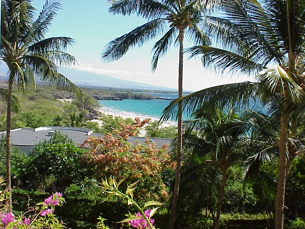
Big Island beauty!
Photo Credit: Google.com
The locally gusty trade winds will continue to blow, although at the same time…providing generally good weather. A strong 1040 millibar high pressure system is the source of these strong and gusty winds Wednesday night. These winds are strong enough to keep small craft wind advisories active across most of the Hawaiian coastal and channel waters, from Kauai down through the Big Island. Those areas that are more protected from the trade winds will have lighter winds as usual. The high surf advisory remains active in response to the large waves generated by these gusty trade winds…along the east facing windward shores.
The local atmosphere is generally quite dry, although with the trade winds this strong…there will be a few windward biased showers. Looking at this satellite image, shows the next wave of high cirrus clouds looming to the west of the islands. The leading edge of this icy moisture looks pretty thin, although could become a bit thicker during the day Thursday. This larger view shows the extent of this cirrus. At lower levels of the atmosphere, we see some moisture pockets being carried in our direction, although nothing organized is taking aim on our islands at this time.
The speedy winds will continue to be the most remarkable weather feature here in the islands, although interestingly enough, it won’t be windy everywhere. The direction of our trade winds continues to show an ever so slight veering to the south of east. The trade winds typically blow from the east-northeast to east. This ESE direction puts some areas of the state in the wind shadow of the larger mountains…especially on Maui and the Big Island. Case in point: Kihei and Kula, Maui, have both had generally light winds the last several days, even though some areas on Maui have experienced 40+ mph gusts. It just depends upon the exposure to these ESE winds, and how different areas are oriented to the wind flow.
I’m about ready to leave Kihei, for the drive over to Kahului. This evening I’m going to see a film at the Maui Arts and Cultural Center, since Thursday is a holiday here in the islands. This film is called Owl and the Sparrow (2007). The story happens in modern day Saigon, with three lonely strangers forming a unique family, as a ten-year old orphan plays matchmaker to a zookeeper, and a beautiful flight attendant. Apparently this is a moving film, which won the Audience Award at the 2008 Los Angeles Film Festival. It is in Vietnamese, with English subtitles. I’m in the mood for a charming film such as this, and will give you my impression Thursday morning. Here’s a trailer for the film, which looks good to me. I trust that you will have a great Wednesday night, along with an invitation to join me here again soon! Aloha for now…Glenn.
Interesting: Fish caught near wastewater treatment plants serving five major U.S. cities had residues of pharmaceuticals in them, including medicines used to treat high cholesterol, allergies, high blood pressure, bipolar disorder and depression, researchers reported Wednesday. Findings from this first nationwide study of human drugs in fish tissue have prompted the Environmental Protection Agency to significantly expand similar ongoing research to more than 150 different locations.
"The average person hopefully will see this type of a study and see the importance of us thinking about water that we use every day, where does it come from, where does it go to? We need to understand this is a limited resource and we need to learn a lot more about our impacts on it," said study co-author Bryan Brooks, a Baylor University researcher and professor who has published more than a dozen studies related to pharmaceuticals in the environment.
A person would have to eat hundreds of thousands of fish dinners to get even a single therapeutic dose, Brooks said. But researchers including Brooks have found that even extremely diluted concentrations of pharmaceutical residues can harm fish, frogs and other aquatic species because of their constant exposure to contaminated water.
Interesting2: A newly laid, 32-mile underwater cable finally links the state’s only seafloor seismic station with the University of California, Berkeley’s seismic network, merging real-time data from west of the San Andreas fault with data from 31 other land stations sprinkled around Northern and Central California. Laying of the MARS (Monterey Accelerated Research System) fiber-optic cable was completed in 2007 by the Monterey Bay Aquarium Research Institute (MBARI) to power and collect data from a cluster of scientific instruments nearly 3,000 feet below the surface of Monterey Bay, 23 miles from the coastal town of Moss Landing.
A broadband seismometer that had been placed on the seafloor in 2002 was connected to the cable on Feb. 27, 2009, obviating the need to send a remotely operated vehicle (ROV) every three months to replace the battery and collect data. "Before, we had to wait three months to even know if the instruments were alive," said Barbara Romanowicz, director of the Berkeley Seismological Laboratory and a UC Berkeley professor of earth and planetary science.
Now, she said, "we can use the data from the seafloor station in real time together with those from the rest of the Berkeley Digital Seismic Network" to determine the location, magnitude and mechanism of offshore earthquakes, learn about the crust at the edge of the continental plate and understand better the hazards of the San Andreas fault system that runs north and south through the state.
According to Romanowicz, earthquake monitoring systems around the world have been trying to place seismometers on the seafloor for decades to cover the 71 percent of the Earth’s surface that is beneath the oceans. Islands have generally provided the only offshore data – the Berkeley network has one seismic station on the Farallon Islands – but these provide only spotty coverage.
Because the state’s main fault system, the San Andreas, runs along the Northern California coast, seafloor monitors are particularly critical. All but one station – the Farallon station – are east of the fault, making it hard to gain a comprehensive view of the fault system.
Interesting3: A brilliant green tree frog with huge black eyes, jumping spiders and a striped gecko are among more than 50 new animal species scientists have discovered in a remote, mountainous region of Papua New Guinea. The discoveries were announced Wednesday by Washington D.C.-based Conservation International, which spent the past several months analyzing more than 600 animal species the group found during its expedition to the South Pacific island nation in July and August.
Of the animals discovered, 50 spider species, three frogs and a gecko appear to have never been described in scientific literature before, the conservation group said. The new frogs include a tiny brown animal with a sharp chirp, a bug-eyed bright green tree frog and another frog with a loud ringing call. One of the jumping spiders is shiny and pale green, while another is furry and brown.
In a sharp reversal of Bush administration policies, the head of the Environmental Protection Agency said Tuesday that the agency planned an aggressive review of permit requests for mountaintop coal mining, citing serious concerns about potential harm to water quality.
The administrator, Lisa P. Jackson, said her agency had sent two letters to the Army Corps of Engineers on Monday in which it expressed concern about two proposed mining operations in West Virginia and Kentucky involving mountaintop removal, a form of strip mining that blasts the tops off mountains and dumps leftover rock in valleys, burying streams.
Interesting4: Red jasper cored from layers 3.46 billion years old suggests that not only did the oceans contain abundant oxygen then, but that the atmosphere was as oxygen rich as it is today, according to geologists. This jasper or hematite-rich chert formed in ways similar to the way this rock forms around hydrothermal vents in the deep oceans today. "Many people have assumed that the hematite in ancient rocks formed by the oxidation of siderite in the modern atmosphere," said Hiroshi Ohmoto, professor of geochemistry, Penn State.
"That is why we wanted to drill deeper, below the water table and recover un-weathered rocks." The researchers drilled diagonally into the base of a hill in the Pilbara Craton in northwest Western Australia to obtain samples of jasper that could not have been exposed to the atmosphere or water. These jaspers could be dated to 3.46 billion years ago. "Everyone agrees that this jasper is 3.46 billion years old," said Ohmoto.
"If hematite were formed by the oxidation of siderite at any time, the hematite would be found on the outside of the siderite, but it is found inside," he reported in a recent issue of Nature Geoscience. Interesting5: Maize was domesticated from its wild ancestor more than 8700 years according to biological evidence uncovered by researchers in the Mexico’s Central Balsas River Valley.
Interesting5: This is the earliest dated evidence — by 1200 years — for the presence and use of domesticated maize. According to Ranere, recent studies have confirmed that maize derived from teosinte, a large wild grass that has five species growing in Mexico, Guatemala and Nicaragua. The teosinte species that is closest to maize is Balsas teosinte, which is native to Mexico’s Central Balsas River Valley.
"We went to the area where the closest relative to maize grows, looked for the earliest maize and found it," said Ranere. "That wasn’t surprising since molecular biologists had determined that Balsas teosinte was the ancestral species to maize. So it made sense that this was where we would find the earliest domestication of maize."
The study began with Piperno, a Temple University anthropology alumna, finding evidence in the form of pollen and charcoal in lake sediments that forests were being cut down and burned in the Central Balsas River Valley to create agricultural plots by 7000 years ago. She also found maize and squash phytoliths — rigid microscopic bodies found in many plants — in lakeside sediments. Ranere, an archaeologist, joined in the study to find rock shelters or caves where people lived in that region thousands of years ago.
His team carried out excavations in four of the 15 caves and rock shelters visited in the region, but only one of them yielded evidence for the early domestication of maize and squash. Ranere excavated the site and recovered numerous grinding tools. Radiocarbon dating showed that the tools dated back at least 8700 years.
Although grinding tools were found beneath the 8700 year level, the researchers were not able to obtain a radiocarbon date for the earliest deposits. Previously, the earliest evidence for the cultivation of maize came from Ranere and Piperno’s earlier research in Panama where maize starch and phytoliths dated back 7600 years.
Interesting6: She may have ruled like a man, but Egyptian queen Hatshepsut still preferred to smell like a lady. The world may be able to get a whiff of that ancient royal scent when researchers complete their investigation into the perfume worn by Hatshepsut, the powerful pharaoh-queen who ruled over ancient Egypt for 20 years beginning around 1479 B.C. Analyzing a metal jar belonging to the famous queen , the team from the Bonn University Egyptian Museum in Germany recently found residue thought to be leftovers from Hatshepsut’s own perfume.
Their next step will be attempting to "reconstruct" the scent, which was likely made from pricey incense imported from present-day Somalia. Though funerary objects belonging to Egypt’s ancient rulers fill museums around the world, if successful, this will be the first time that a pharaoh’s perfume is recreated, the researchers said. Hatshepsut stepped in as one of ancient Egypt’s rare female leaders when her half-brother and husband, Pharaoh Thutmose II, died without an adult male heir.
She was meant to rule as a co-regent only until her stepson Thutmose III matured, but she effectively took the reins and was recognized as the pharaoh by the royal court and religious officials until her death in 1457 B.C., Egyptologists say. Despite her gender, Hatshepsut’s two decades as pharaoh are considered an incredibly successful time. Ruling like a man, historians say, she mounted at least one military campaign but kept Egypt largely peaceful, and commissioned several impressive building projects.
Hatshepsut is best known, perhaps, for reopening southern trade routes that had been interrupted by war, increasing the wealth of her empire. She famously launched a naval caravan to the ancient land of Punt — what today is called the Horn of Africa — bringing back ships laden with myrrh, frankincense and, notably, incense plants which were then replanted near her funerary temple (commonly under construction well before a pharaoh’s death), according to ancient documents.
"Incense was extremely valuable in ancient Egypt and was used only in temples and for living gods (such as the king)," said Michael Höveler-Müller, curator of the Bonn University Egyptian Museum. It is this incense that researchers suspect they have found in a filigree container bearing the queen’s name. Using powerful X-rays, the remains of a dried-out fluid were discovered at the bottom of the flacon. Pharmacologists will now analyze the residue and break it into its constituents, in the hopes of putting the scent back together, 3,500 years after Hatshepsut last wore it.
Posted by Glenn
No Comments
March 24-25, 2009
Air Temperatures – The following maximum temperatures were recorded across the state of Hawaii Tuesday afternoon:
Lihue, Kauai – 75
Honolulu, Oahu – 81
Kaneohe, Oahu – 77
Kahului, Maui – 82
Hilo, Hawaii – 78
Kailua-kona – 81
Air Temperatures ranged between these warmest and coolest spots near sea level – and on the highest mountains…at 4 p.m. Tuesday afternoon:
Kailua-kona – 79F
Princeville, Kauai – 73
Haleakala Crater – missing (near 10,000 feet on Maui)
Mauna Kea summit – 23 (near 14,000 feet on the Big Island)
Precipitation Totals – The following numbers represent the largest precipitation totals (inches) during the last 24 hours on each of the major islands, as of early Tuesday afternoon:
3.37 Mount Waialaele, Kauai
2.29 Poamoho 2, Oahu
0.10 Molokai
0.00 Lanai
0.00 Kahoolawe
1.40 West Wailuaiki, Maui
1.60 Piihonua, Big Island
Weather Chart – Here’s the latest (automatically updated) weather map showing a strong 1039 millibar high pressure system far to the northeast of the islands. Our trade winds will be moderate to locally strong and gusty Wednesday and Thursday…lighter in those more protected places.
Satellite and Radar Images: To view the cloud conditions we have here in Hawaii, please use the following satellite links, starting off with the Infrared Satellite Image of the islands to see all the clouds around the state during the day and night. This next image is one that gives close images of the islands only during the daytime hours, and is referred to as a Close-up visible image. This next image shows a larger view of the Pacific…giving perspective to the wider ranging cloud patterns in the Pacific Ocean. Finally, here’s a looping IR satellite image, making viewable the clouds around the islands 24 hours a day. To help you keep track of where any showers may be around the islands, here’s the latest animated radar image.
Hawaii’s Mountains – Here’s a link to the live webcam on the summit of near 14,000 foot Mauna Kea on the Big Island of Hawaii. The tallest peak on the island of Maui is the Haleakala Crater, which is near 10,000 feet in elevation. These two webcams are available during the daylight hours here in the islands…and when there’s a big moon rising just after sunset for an hour or two! Plus, during the nights and early mornings you will be able to see stars, and the sunrise too…depending upon weather conditions.
Aloha Paragraphs

Coconut palms, sunset…north shore of Oahu
Photo Credit: Google.com
The gusty trade winds will continue, through the rest of this week, right on into next week…which is fairly normal for this time of year. A strong 1039 millibar high pressure system, far to the northeast of Hawaii, is the source of these strong and gusty trade winds Tuesday night. These winds are strong enough to keep small craft wind advisories active in just about all Hawaiian coastal and channel waters, from Kauai down through the Big Island. Those areas that are more protected from the trade winds will have lighter winds as usual. By the way, a NWS issued high surf advisory, is active in response to the large waves generated by the gusty trade winds…along the east facing windward shores.
The windward sides, and some mountain areas, will see passing showers, generally at night…while most leeward sides will remain dry through mid-week. Looking at this satellite image, we see a diminishing amount of that high cloudiness over and around the Hawaiian Islands now. There are no organized rainmakers on our weather horizon at this time. Days will be nice, with more sunshine slated for our beaches well into the future.
This last week of March 2009 will remain favorably inclined, in terms of our weather here in the Hawaiian Islands. The most most noticeable weather feature will be the gusty trade winds. As this weather map shows, we have a strong 1039 millibar high pressure system located far to the northeast. This high pressure system is monopolizing the entire eastern Pacific Ocean, with its southwestern flank extending down across the Hawaiian Islands. The trade winds blow typically around 61% of the time, on average during the month of March.
It’s difficult to find anything too unusual about any of the weather happening here in the islands now. As has been pointed out above, the trade winds are definitely a bit stronger than usual…with some very strong gusts locally. Rainfall remains well within the normal boundaries, although some of the mountain areas, especially on Kauai and Oahu, have received some generous amounts during the last 24 hours. Those high clouds seem to be fading now, which will allow even more sunshine to beam down Wednesday. The surf is rolling in along our beaches, the largest of which is breaking along our east facing shores…thanks to the wind swell generated by the gusty trade winds. A new west-northwest swell will bring the surf up along our north and west facing beaches late Wednesday into Thursday.
I left Kihei, and rushed back up to Kula, where I had a tax appointment. I’m home now, and remembering how the weather was Tuesday, am delighted to tell you that it was quite special. The high cloudiness diminished during the day, although glancing outside just before sunset, it appears that we still may get a bit of color in a little while. The main thing, or the most dynamic thing today, was by far the strong and gusty trade winds. At one point, there were 40+ mph gusts in those windiest places, with South Point on the Big Island, topping out with a remarkable 50 mph gust early Tuesday afternoon! At around 630pm, there were still 43 mph gusts at both Upolu Point on the Big Island, and on Kahoolawe. I expect more of these locally very strong gusts Wednesday. ~~~ It’s almost sunset, so I want to go sit out on my weather deck to see it. I’ll be back early Wednesday morning with your next new weather narrative from paradise. I hope you have a grand Tuesday night wherever you happen to be spending it! Aloha for now…Glenn.
Interesting: In the future, natural gas derived from chunks of ice that workers collect from beneath the ocean floor and beneath the arctic permafrost may fuel cars, heat homes, and power factories. Government researchers are reporting that these so-called "gas hydrates," a frozen form of natural gas that bursts into flames at the touch of a match, show increasing promise as an abundant, untapped source of clean, sustainable energy. The icy chunks could supplement traditional energy sources that are in short supply and which produce large amounts of carbon dioxide linked to global warming, the scientists say.
"These gas hydrates could serve as a bridge to our energy future until cleaner fuel sources, such as hydrogen and solar energy, are more fully realized," says study co-leader Tim Collett, Ph.D., a research geologist with the U.S. Geological Survey (USGS) in Denver, Colo. Gas hydrates, known as "ice that burns," hold special promise for helping to combat global warming by leaving a smaller carbon dioxide footprint than other fossil fuels, Collett and colleagues note.
Last November, a team of USGS researchers that included Collett announced a giant step toward that bridge to the future. In a landmark study, the USGS scientists estimated that 85.4 trillion cubic feet of natural gas could potentially be extracted from gas hydrates in Alaska’s North Slope region, enough to heat more than 100 million average homes for more than a decade.
"It’s definitely a vast storehouse of energy," Collett says. "But it is still unknown how much of this volume can actually be produced on an industrial scale." That volume, he says, depends on the ability of scientists to extract useful methane, the main ingredient in natural gas, from gas hydrate formations in an efficient and cost-effective manner. Scientists worldwide are now doing research on gas hydrates in order to understand how this strange material forms and how it might be used to supplement coal, oil, and traditional natural gas.
Although scientists have known about gas hydrates for decades, they’ve only recently begun to try to use them as an alternative energy source. Gas hydrates, also known as "clathrates," form when methane gas from the decomposition of organic material comes into contact with water at low temperatures and high pressures. Those cold, high-pressure conditions exist deep below the oceans and underground on land in certain parts of the world, including the ocean floor and permafrost areas of the Arctic.
Interesting2: Even after nine months soaking in the womb, a newborn’s skin is smooth – unlike an adult’s in the bath. While occupying a watery, warm environment, the newborn manages to develop a skin fully equipped to protect it in a cold, dry and bacteria-infected world. A protective cream called Vernix caseosa (VC), which covers the fetus and the newborn, aids in the growth of skin both before and after birth. VC provides ‘waterproofing’ in utero, allowing skin to grow in wet conditions, while after birth it hydrates and cleanses, even healing when applied to ulcers.
Prof. Joke Bouwstra, a specialist in the skin barrier and its synthesis at Leiden University, and her colleague Robert Ribmann set out to study VC in detail and has produced a synthetic version of this natural buttery ointment which shows the same structure and unique properties. As well as helping pre-term babies develop essential protection against temperature changes, dehydration and infection, artificial VC could also benefit sufferers of skin disease.
Interesting3: The U.S. Environmental Protection Agency found that climate-warming greenhouse gases, including carbon dioxide, pose a danger to human health and welfare, a White House website showed on Monday. EPA’s proposed "endangerment finding," sent to the Obama administration on Friday, could pave the way for U.S. limits on emissions that spur climate change. The substance of the proposal was not immediately made public, but the White House Office of Management and Budget showed EPA sent a proposed rule for an "Endangerment Finding for Greenhouse Gases under the Clean Air Act."
An endangerment finding is essential for the U.S. government to regulate climate-warming emissions like carbon dioxide under the Clean Air Act. The environment agency had no comment on the endangerment finding, but such a finding is only sent to the White House when the EPA determines that human health and welfare are threatened.
Interesting4: The modest global warming trend has stopped – maybe even reversed itself. And it’s not just the record low temperatures experienced in much of the world this winter. For at least the last five years, global temperatures have been falling, according to tracking performed by Roy Spencer, the climatologist formerly of NASA. "Global warming" was going to bring more and more horrific hurricanes, climate change scientists and the politicians who subscribed to their theories said.
But since 2005, only one major hurricane has struck North America. A new study by Florida State University researcher Ryan Maue shows worldwide cyclone activity – typhoons, as well as hurricanes – has reached at least a 30-year low. Two more studies – one by the Leibniz Institute of Marine Science and the Max Planck Institute of Meteorology in Germany and another by the University of Wisconsin – predict a slowing, or even a reversal of warming, for at least the next 10 to 20 years.
The Arctic sea ice has grown more on a percentage basis this winter than it has since 1979. The number of polar bears has risen 25 percent in the past decade. There are 15,000 of them in the Arctic now, where 10 years ago there were 12,000. "The most recent global warming that began in 1977 is over, and the Earth has entered a new phase of global cooling," says Don Easterbrook, professor of geology at Western Washington University in Bellingham, confidently. He maintains a switch in Pacific Ocean currents "assures about three decades of global cooling.
New solar data showing unusual absence of sun spots and changes in the sun’s magnetic field suggest … the present episode of global cooling may be more severe than the cooling of 1945 to 1977." Climatologist Joe D’Aleo of the International Climate and Environmental Change Assessment Project, says new data "show that in five of the last seven decades since World War II, including this one, global temperatures have cooled while carbon dioxide has continued to rise." "The data suggest cooling not warming in Earth’s future," he says.
Interesting5: When the mood strikes her, Bonnie whistles. She’s not very good at it — she utters only single notes and can’t carry a tune. But don’t judge her too harshly; as an orangutan, she’s the first nonhuman primate ever documented to whistle, or to spontaneously mimic the sound of another species. Now thirty years old, Bonnie lives at the Smithsonian’s National Zoological Park in Washington, D.C.
In the 1980s, she probably heard a happy caretaker whistling, and she soon made whistles of her own, seemingly just for the fun of it. Recently, a team of primatologists, led by Serge A. Wich of the Great Ape Trust of Iowa in Des Moines, took a closer look at Bonnie’s abilities. By comparing recordings, they confirmed that the sounds she makes are nothing like normal orangutan sounds or vocalizations, and that her whistling tends to be imitative.
For example, she usually replicates the duration and number of whistles (one or two) that caretakers produce in front of her. Other orangutans and chimpanzees known to produce unusual sounds have typically received extensive training — yet Bonnie isn’t alone in her spontaneous whistling. Another National Zoo orangutan named Indah also took up the habit, but died before she was recorded. And Wich says that since publishing, he’s heard from workers at other zoos with whistling orangutans in their care.
Interesting6: A cosmetic surgery technique called laser resurfacing is soaring in popularity as men and women flock to clinics to get their wrinkles smoothed out. Over the past three years, the number of procedures has increased 456 percent among men and 215 percent among women, according to new numbers released today by the American Academy of Cosmetic Surgery. Laser resurfacing involves pulses from a carbon dioxide laser to minimize wrinkles and lines.
The laser vaporizes water molecules in skin cells, damaging the surrounding tissue. In response, the skin produces more of the protein collagen, which fills in wrinkles. While the recession has dampened enthusiasm for many popular cosmetic procedures, de-wrinkling seems to be somewhat immune.
"These laser procedures are looking to be recession proof," according to a statement from the academy. Studies suggest the laser resurfacing does indeed reduce wrinkles, at least for a time. Wrinkles are caused by a structural breakdown inside the skin.
Some existing treatments effectively counteract the breakdown by stimulating the growth of new collagen from cells called fibroblasts. As skin ages, fibroblasts collapse and there is an increase in the production of collagenase, which breaks down collagen, researchers at the University of Michigan explained in writing about a study they did on all this last year. People in their 80s have four times more broken collagen than people in their 20s, they said.
Posted by Glenn
No Comments
March 23-24, 2009
Air Temperatures – The following maximum temperatures were recorded across the state of Hawaii Monday afternoon:
Lihue, Kauai – 75
Honolulu, Oahu – 81
Kaneohe, Oahu – 77
Kahului, Maui – 80
Hilo, Hawaii – 78
Kailua-kona – 81
Air Temperatures ranged between these warmest and coolest spots near sea level – and on the highest mountains…at 4 p.m. Monday afternoon:
Barking Sands, Kauai – 80F
Hilo, Hawaii – 72
Haleakala Crater – missing (near 10,000 feet on Maui)
Mauna Kea summit – 30 (near 14,000 feet on the Big Island)
Precipitation Totals – The following numbers represent the largest precipitation totals (inches) during the last 24 hours on each of the major islands, as of early Monday afternoon:
0.88 Mount Waialaele, Kauai
0.18 Poamoho 2, Oahu
0.00 Molokai
0.00 Lanai
0.00 Kahoolawe
0.11 West Wailuaiki, Maui
1.31 Glenwood, Big Island
Weather Chart – Here’s the latest (automatically updated) weather map showing a strong 1038 millibar high pressure system far to the northeast of the islands. Our trade winds will be moderate to locally strong and gusty Tuesday and Wednesday…lighter in those more protected places.
Satellite and Radar Images: To view the cloud conditions we have here in Hawaii, please use the following satellite links, starting off with the Infrared Satellite Image of the islands to see all the clouds around the state during the day and night. This next image is one that gives close images of the islands only during the daytime hours, and is referred to as a Close-up visible image. This next image shows a larger view of the Pacific…giving perspective to the wider ranging cloud patterns in the Pacific Ocean. Finally, here’s a looping IR satellite image, making viewable the clouds around the islands 24 hours a day. To help you keep track of where any showers may be around the islands, here’s the latest animated radar image.
Hawaii’s Mountains – Here’s a link to the live webcam on the summit of near 14,000 foot Mauna Kea on the Big Island of Hawaii. The tallest peak on the island of Maui is the Haleakala Crater, which is near 10,000 feet in elevation. These two webcams are available during the daylight hours here in the islands…and when there’s a big moon rising just after sunset for an hour or two! Plus, during the nights and early mornings you will be able to see stars, and the sunrise too…depending upon weather conditions.
Aloha Paragraphs

The wonderful colors of Hawaii…and the Hula kids!
Photo Credit: Google.com
The trade winds will blow steadily through this new work week…then gradually become softer by the weekend. A strong 1037 millibar high pressure system, far to the northeast of Hawaii, is the source of these rather strong and gusty trade winds Monday evening. These winds are strong enough to keep small craft wind advisories active in just about all Hawaiian coastal and channel waters, from Kauai down through the Big Island. Those areas that are more protected from the trade winds will have lighter winds as usual.
We have a temporary break from the high cirrus clouds, which have been around for the last several days…allowing lots of warm sunshine through now. Looking at this satellite image, we see more of that high cloudiness up to the northwest of Kauai. This may sweep down over some parts of the state tonight, especially on the Garden Island. The only showers that are expected, will be those few being carried towards the windward coasts and slopes…most often during the night and early morning hours. There are no organized rainmakers on our weather horizon at this time.
As noted in the two paragraphs above, we are now involved in what can be considered…a fairly normal early spring trade wind weather pattern. These winds will remain amply strong to chalk-up our ocean surface with countless white caps. At the same time, our coconut palm trees will be bending over under their influence as well. The winds are blowing from a direction that is slightly south of directly east. We refer to this direction as east-southeast, which puts some locations in a minor wind shadow. These areas will have some protection from the gusty winds, and will be where the best beaching prospects will happen through Tuesday.
As for the rainfall, there won’t be too much, with just the typical showers falling along the windward sides. As usual, the nights and early morning hours will have the most common showers falling. The leeward sides, the south and west facing beaches, will tend to be completely dry. Looking at this looping radar image, confirms that nothing much is being carried our way on the trade wind flow. The most frequent showers, at least for the moment, appear to be heading towards the windward side of the Big Island. The fuzzy area, that comma shaped hook near the Big Island, isn’t precipitation, but rather sea spray being picked up by the low beam of the radar…there’s a little of that going on for Kauai too.
It’s been a simply beautiful day here in the Islands Monday…the kind that the chamber of commerce loves to see! There were several sea level locations, including Honolulu, Kahului, and Kailua-kona, that reached 80F degrees, or a little more during the afternoon hours. The trade winds were warm, and slightly humid, as they came towards us, a tad south of directly east. This made the air temperatures Monday feel a little warmer than the thermometers actually registered. ~~~ Looking out the window here in Kihei, before I leave for the drive upcountry to Kula, it’s a bit hazy, and partly cloudy in general. The high clouds, which are evident up near Kauai, didn’t slide down over the rest of the state today, as shown by that satellite image above. They may edge further into the state with time, beautifying our local skies in the process. ~~~ I expect Monday night to be slightly cooler than normal in a few places, like Kahului, Maui again, while others, that are more exposed to the ESE winds, to remain near 70 overnight, or even a few degrees warmer than that. Upcountry in Kula, at my house, I’ll make a guess that the low temperature will be near 46 degrees again Tuesday morning, as it was Monday morning. I hope you have a great Monday night wherever you happen to be reading from, and that you will join me here again Tuesday! Aloha for now…Glenn.
Interesting: Alaska’s Mount Redoubt Volcano has erupted, spewing ash thousands of feet into the air. The volcano, 106 miles southwest of Anchorage, erupted explosively on March 22, 2009, at approximately 10:38 PM AKDT, sending a cloud of volcanic ash to an estimated 50,000 feet above sea level. Scientists from the Alaska Volcano Observatory (AVO) are monitoring the volcano closely as the eruption continues.
Ash plumes generated by the explosive bursts are drifting north-northeast. Ash fall has been reported in Skwentna and the Chuitna area. The eruption follows an increase March 15 of seismic activity at Mount Redoubt, when approximately four hours of continuous volcanic tremor ensued.
The onset of the tremor was associated with a small explosion that produced a plume of gas and ash that rose to about 15,000 feet above sea level and deposited a trace amount of ash over the summit-crater floor and down the south flank of the volcano to about 3,000 feet.
The Alaska Volcano Observatory is a cooperative program of the U.S. Geological Survey, the University of Alaska Fairbanks Geophysical Institute, and the Alaska Division of Geological and Geophysical Surveys.
Interesting2: At least 63 whales of a pod of 80 that came ashore near Margaret River on Australia’s west coast on Monday have died. Residents and tourists at Margaret River, 270 kilometres south of Perth, called in help after early morning walkers found the pod of long-finned pilot whales and dolphins at Hamelin Bay. Initial reports stated the stranded creatures were False Killer Whales, but a Department of Environment and Conservation (DEC) spokesman said that on closer inspection they were pilot whales.
"The main strategy is to regroup the animals, which are spread over five to six kilometres of beach, into one pod and hold them overnight in Hamelin Bay until daybreak when they will be transported by truck to Flinders Bay for release (on Tuesday)," DEC spokesman Greg Mair said in a statement.
Mair said Flinders Bay was picked because it is sheltered and far enough away from the original stranding site to deter the whales from coming back on shore. Liz Carion, one of 100 volunteers caring for the whales, said the scene was one of great sorrow. "I have never seen this sort of thing happen in real life," she said. "I have only seen it with photos.
But I went down to the beach to have a look myself and … just held back the tears. I thought one was still alive because there is a bit of a swell down here, and the dorsal fin or part of the whale had moved, but it wasn’t, it was just the waves." Opinions differ on why strandings happen. Whales are highly socialized animals and seemed wired to come to the aid of one of their number that gets into difficulties in shallow water.
Interesting3: Tens of thousands of animals were at risk in Kenya on Monday after forest fires sent wildlife fleeing and dried up water sources in a country already suffering from drought. A fire at Mount Longonot, an extinct volcano popular with hikers, continued to burn on Monday, with game wardens concerned that animals such as baboons, rabbits and mongoose were trapped inside the crater of the extinct volcano.
On Sunday, thousands of zebras, buffalo, giraffes and antelopes fled the blaze in the Longonot National Park, blundering through villages and across busy roads. Other fires broke out over the weekend, with particular concern caused by a blaze in the Mau forest in south-west Kenya. According to the Kenya Wildlife Service (KWS), many of the rivers feeding Lake Nakuru – home to hundreds of thousands of flamingoes – have partially dried up because of the blaze.
Authorities suspect the fire in the Mau forest was started by settlers that the government is trying to move out of the forest. The KWS has previously warned that human settlement in the Mau forest was drying up the rivers and threatening Lake Nakuru. Kenya is facing a drought that the government says is leaving up to 10 million people hungry.
Interesting4: Deep-sea corals are the oldest living animals with a skeleton in the seas, claims new research that found a 4,265-year-old coral species off the coast of Hawaii. Deep-sea corals, which are threatened by climate change and pollution like shallow water corals are, grow on seamounts (mountains rising from the seafloor that don’t reach the ocean’s surface) and continental margins at depths of about 1,000 to 10,000 feet (300 to 3,000 meters). These corals play host to many other marine organisms, and are hotspots of ocean biodiversity.
The largest coral reef system in the world is the Great Barrier Reef off the coast of Queensland, Australia. Big reefs are also found in the Red Sea, along the coast of Mexico and Belize, the Bahamas and the Maldives. Samples of two species examined in the study, gold coral (Gerardia sp.) and deep-water black coral (Leiopathes sp.), were gathered from off the coast of Hawaii with submersibles. Previous estimates of the corals’ ages, made by counting what were thought to be annual growth rings, put the maximum age for Gerardia sp. in Hawaii at about 70 years.
But radiocarbon studies had pinned ages of about 2,000 to 3,000 years on other Gerardia colonies in the Atlantic and Pacific. Similar dates were found for some Leiopathes specimens. Brendan Roark of Texas A&M University in College Station, Texas, and his colleagues made radiocarbon measurements of the skeletons of the Hawaiian specimens and came up with similarly ancient ages: about 2,742 years for Gerardia and 4,265 years for Leiopathes.
"These results show that Leiopathes is the oldest skeletal-accreting marine organism known and, to the best of our knowledge, the oldest colonial organism yet found," the study authors wrote. Their findings are detailed in the March 23 issue of the journal Proceedings of the National Academy of Sciences. The ages imply that the corals’ skeletons grow much more slowly than previously thought, only a few micrometers a year (one micrometer is about the diameter of a human blood cell).
Interesting5: Toxic algal blooms are bad enough on the ocean surface, but now it turns out that the toxin in them sinks to the ocean floor – where it persists for weeks. Far from degrading soon after the bloom, as previously assumed, new research suggests that the neurotoxin that causes shellfish poisoning, domoic acid, sinks to the ocean floor and could poison marine mammals, birds and humans.
"The first signs of an algal bloom are often birds washing up on the shore or seals acting funny, aggressive and twitching, looking as if they were drunk," says Claudia Benitez-Nelson of the University of South Carolina. "We used to think that once the bloom died, the danger was over, but now it turns out that domoic acid is a ‘gift’ that just keeps on giving."
Benitez-Nelson’s team are the first to look for the chemical in algae particles sinking through the ocean, as well as in sediment samples on the ocean floor, up to 800 meters down. They found copious amounts of the neurotoxin, reaching concentrations eight times the US federal limit for the substance in shellfish.
The team also compared the peak of domoic acid levels from the sediment with those of algae blooms at the surfaces. Their findings indicate that the toxin reaches the bottom of the ocean in only three days but stays there for much longer – at least several weeks. The speedy trip to the bottom is probably driven by dead algae clumping together at the surface to form heavier aggregates, says the team, a process that also protects the toxin from degradation.
Interesting6: Scientists at the Great Lakes Environmental Research Laboratory say there has been more than a 30% ice decline on the lakes since the 1970s. The drop attributed to global climate change leaves the largest system of freshwater lakes on Earth open to evaporation that can lead to lower lake levels. Ice also protects the shoreline from erosion and protects underwater fish eggs.
Scientists who have studied the lakes at the lab in Ann Arbor, Mich., say the waters also are influenced by natural cycles that counter global warming. Researcher Jia Wang says natural variability is at least as large a factor as global warming. He says regional climate patterns and global climate change are competing over the Great Lakes.
Posted by Glenn
No Comments
March 22-23, 2009
Air Temperatures – The following maximum temperatures were recorded across the state of Hawaii Sunday afternoon:
Lihue, Kauai – 76
Honolulu, Oahu – 82
Kaneohe, Oahu – 77
Kahului, Maui – 81
Hilo, Hawaii – 75
Kailua-kona – 81
Air Temperatures ranged between these warmest and coolest spots near sea level – and on the highest mountains…at 5 p.m. Sunday evening:
Port Allen, Kauai – 79F
Hilo, Hawaii – 72
Haleakala Crater – missing (near 10,000 feet on Maui)
Mauna Kea summit – 30 (near 14,000 feet on the Big Island)
Precipitation Totals – The following numbers represent the largest precipitation totals (inches) during the last 24 hours on each of the major islands, as of early Sunday evening:
4.73 Mount Waialaele, Kauai
0.26 Poamoho 2, Oahu
0.00 Molokai
0.00 Lanai
0.00 Kahoolawe
0.22 West Wailuaiki, Maui
0.34 Piihonua, Big Island
Weather Chart – Here’s the latest (automatically updated) weather map showing a strong 1037 millibar high pressure system far to the northeast of the islands. Our trade winds will be moderate to locally strong and gusty Monday and Tuesday…lighter in those more protected places.
Satellite and Radar Images: To view the cloud conditions we have here in Hawaii, please use the following satellite links, starting off with the Infrared Satellite Image of the islands to see all the clouds around the state during the day and night. This next image is one that gives close images of the islands only during the daytime hours, and is referred to as a Close-up visible image. This next image shows a larger view of the Pacific…giving perspective to the wider ranging cloud patterns in the Pacific Ocean. Finally, here’s a looping IR satellite image, making viewable the clouds around the islands 24 hours a day. To help you keep track of where any showers may be around the islands, here’s the latest animated radar image.
Hawaii’s Mountains – Here’s a link to the live webcam on the summit of near 14,000 foot Mauna Kea on the Big Island of Hawaii. The tallest peak on the island of Maui is the Haleakala Crater, which is near 10,000 feet in elevation. These two webcams are available during the daylight hours here in the islands…and when there’s a big moon rising just after sunset for an hour or two! Plus, during the nights and early mornings you will be able to see stars, and the sunrise too…depending upon weather conditions.
Aloha Paragraphs

Nice looking Hawaiian golf course
Photo Credit: Google.com
A fairly typical trade wind weather pattern will prevail through the next week…at least. These early spring trades remain well established Sunday evening, and will continue blowing through the new week ahead. For the moment, these winds are strong enough to keep small craft wind advisories active in just about all Hawaiian coastal and channel waters, from Kauai down through the Big Island.
Besides the thin high cirrus clouds locally, and a few passing windward showers…our weather will be fine. Looking at this satellite image, we see some fairly minor high cirrus clouds spreading across our skies at times. The only showers that are expected, will be those few moisture pockets being carried towards the windward coasts and slopes…most often during the night and early morning hours.
I took a great hike with the West Maui Mountains Watershed Partnership Saturday. A couple of friends, who live over in Haiku and I, joined this group for their first official hike. This Partnership is a voluntary effort by public and private landowners to preserve and protect nearly 50,000 acres at the forested core of West Maui. The Partnership works in the West Maui Mountains, also known as the Mauna Kahalawai, where elevations range from the summit at 5,788 feet, to near sea level. This managed area supports over 126 rare species and communities, and provides 29 billion gallons of water for Maui’s residential, industrial, and agricultural needs annually.
This Partnership protects the water we drink here on Maui, at least in West Maui. They do weed assessment and control…non-native invasive plants compete with and displace native plants. They work towards endangered species protection…nearly 60% of Hawaii’s native flora are in danger of becoming extinct. They do major fence building…over 15 miles of fencing protects nearly 18,000 acres from wild feral ungulates such as pigs, goats, cattle, and deer. They are big into public outreach…with community involvement being essential to their success. They go by WMMWP, which again stands for West Maui Mountains Watershed Partnership.
I greatly appreciated the contact with the staff from this organization, they were thorough in their presentations…and at the same time very personable. I was also delighted to find out that they all often refer to my website for guidance in weather forecasts. I would recommend taking one of their hikes, and would go back myself. It was special being up in that area, interacting with the gusty trade winds, the occasional passing showers, and the sun too…when at the end of our hike we all sat together in the sun, enjoying each others company, eating lunch.
Sunday was a lovely day, punctuated at times by the high cirrus clouds…although with lots of sunshine around too. The day was really nice, with warm daytime temperatures all along the sea level locations, and even here in the upcountry area on Maui. At the moment, here in Kula, it’s 6pm, and the temperature is still a relatively warm 66F degrees. It’s still well into 70’s, even middle to upper 70’s down near the beaches at the same time. It actually felt like a normal spring day, with the trade winds blowing, and nothing unusual to catch our attention. ~~~ Other than making a quick trip down to Paia to shop, I remained entrenched at home, resting and recharging my batteries before I launch off into another work week early tomorrow morning. Speaking of which, I’ll be up before 5am Monday morning, first to meditate for about 35 minutes, and then to jump on the computer to update my website…including this narrative page of course. I’d like to wish you a great Sunday night, and to invite you back here as well, as we start our new work week together. Aloha for now…Glenn.
Interesting: Want to know what will make you happy? Then ask a total stranger — or so says a new study from Harvard University, which shows that another person’s experience is often more informative than your own best guess. The study, which appears in the current issue of Science, was led by Daniel Gilbert, professor of psychology at Harvard and author of the 2007 bestseller "Stumbling on Happiness," along with Matthew Killingsworth and Rebecca Eyre, also of Harvard, and Timothy Wilson of the University of Virginia.
"If you want to know how much you will enjoy an experience, you are better off knowing how much someone else enjoyed it than knowing anything about the experience itself," says Gilbert. "Rather than closing our eyes and imagining the future, we should examine the experience of those who have been there."
Previous research in psychology, neuroscience, and behavioral economics has shown that people have difficulty predicting what they will like and how much they will like it, which leads them to make a wide variety of poor decisions. Interventions aimed at improving the accuracy with which people imagine future events have been generally unsuccessful.
So rather than trying to improve human imagination, Gilbert and his colleagues sought to eliminate it from the equation by asking people to predict how much they would enjoy a future event about which they knew absolutely nothing — except how much a total stranger had enjoyed it. Amazingly enough, those people made extremely accurate predictions.
Interesting2: By combining data from 48 studies of coral reefs from around the Caribbean, researchers have found that fish densities that have been stable for decades have given way to significant declines since 1995. "We were most surprised to discover that this decrease is evident for both large-bodied species targeted by fisheries as well as small-bodied species that are not fished," said Michelle Paddack of Simon Fraser University in Canada.
"This suggests that overfishing is probably not the only cause." Rather, they suggest that the recent declines may be explained by drastic losses in coral cover and other changes in coral reef habitats that have occurred in the Caribbean over the past 30 years.
Those changes are the result of many factors, including warming ocean temperatures, coral diseases, and a rise in sedimentation and pollution from coastal development. Overfishing has also led to declines of many fish species, and now seems to also be removing those that are important for keeping the reefs free of algae.
"All of these factors are stressing the reefs and making them less able to recover from disturbances such as hurricanes, which also seem to be occurring more frequently," Paddack said. Scientists had previously documented historical declines in the abundance of large Caribbean reef fishes that probably reflect centuries of overexploitation. However, effects of recent degradation of reef habitats on reef fish had not been established before now.
Interesting3: Nearly one-third of all U.S. bird species are endangered, threatened or in significant decline, with birds in Hawaii facing a "borderline ecological disaster," scientists reported. The State of the Birds report, issued by Interior Secretary Ken Salazar along with conservation groups and university ornithologists, also noted some successes, including the recovery of the bald eagle, the peregrine falcon and other species after the banning of the chemical DDT.
"When we talk about birds and we talk about wildlife, we’re also talking about the economics of this country," Salazar told reporters as the report was released. Wildlife watching and recreation generate $122 billion annually, the report said. Salazar mentioned revenue from hunting, fishing and bird-watching, but added that President Barack Obama’s stimulus package and proposed federal budgets for the remainder of 2009 and 2010 offer more money for the U.S. Fish and Wildlife Service, which aims to protect birds and other creatures.
Interesting4: Salty, liquid water has been detected on a leg of the Mars Phoenix Lander and therefore could be present at other locations on the planet, according to analysis by a group of mission scientists led by a University of Michigan professor. This is the first time liquid water has been detected and photographed outside the Earth. "A large number of independent physical and thermodynamical evidence shows that saline water may actually be common on Mars," said Nilton Renno, a professor in the U-M Department of Atmospheric, Oceanic and Space Sciences and a co-investigator on the Phoenix mission.
"Liquid water is an essential ingredient for life. This discovery has important implications to many areas of planetary exploration, including the habitability of Mars." Renno will present these findings March 23 at the Lunar and Planetary Science Conference in Houston. Previously, scientists believed that water existed on Mars only as ice or water vapor because of the planet’s low temperature and atmospheric pressure.
They thought that ice in the Red Planet’s current climate could sublimate, or vaporize, but they didn’t think it could melt. This analysis shows how that assumption may be incorrect. Temperature fluctuation in the arctic region of Mars where Phoenix landed and salts in the soil could create pockets of water too salty to freeze in the climate of the landing site, Renno says. Photos of one of the lander’s legs show droplets that grew during the polar summer.
Based on the temperature of the leg and the presence of large amounts of "perchlorate" salts detected in the soil, scientists believe the droplets were most likely salty liquid water and mud that splashed on the spacecraft when it touched down.
The lander was guided down by rockets whose exhaust melted the top layer of ice below a thin sheet of soil. Some of the mud droplets that splashed on the lander’s leg appear to have grown by absorbing water from the atmosphere, Renno says. Images suggest that some of the droplets darkened, then moved and merged—physical evidence that they were liquid.
Interesting5: As any parent knows, children love sweet-tasting foods. Now, new research from the University of Washington and the Monell Center indicates that this heightened liking for sweetness has a biological basis and is related to children’s high growth rate. "The relationship between sweet preference and growth makes intuitive sense because when growth is rapid, caloric demands increase.
Children are programmed to like sweet taste because it fills a biological need by pushing them towards energy sources," said Monell geneticist Danielle Reed, PhD, one of the study authors. Across cultures, children prefer higher levels of sweetness in their foods as compared to adults, a pattern that declines during adolescence.
To explore the biological underpinnings of this shift, Reed and University of Washington researcher Susan Coldwell, PhD, looked at sweet preference and biological measures of growth and physical maturation in 143 children between the ages of 11 and 15.
The findings, reported in the journal Physiology & Behavior, suggest that children’s heightened liking for sweet taste is related to their high growth rate and that sweet preferences decline as children’s physical growth slows and eventually stops.
Interesting6: Robot fish developed by British scientists are to be released into the sea off north Spain to detect pollution. If next year’s trial of the first five robotic fish in the northern Spanish port of Gijon is successful, the team hopes they will be used in rivers, lakes and seas across the world. The carp-shaped robots, costing 20,000 pounds ($29,000) apiece, mimic the movement of real fish and are equipped with chemical sensors to sniff out potentially hazardous pollutants, such as leaks from vessels or underwater pipelines. They will transmit the information back to shore using Wi-Fi technology. Unlike earlier robotic fish, which needed remote controls, they will be able to navigate independently without any human interaction.
Interesting7: The volume of toxic chemicals that were released into the environment or sent for disposal in 2007 dropped 5 percent compared with 2006, according to the Environmental Protection Agency. But concealed within the overall numbers was good and bad news. For example, the volume of released or disposed "persistent, bio-accumulative and toxic chemicals," substances like lead, dioxin, mercury and PCBs, was up slightly, the agency said.
Most of those releases were not to air or water, the agency said, meaning that the material was mostly buried in landfills, injected into deep wells or held in impoundments. The number given for PCBs was up by 40 percent, but "it’s good news." said Michael P. Flynn, acting deputy assistant administrator for the Environmental Protection Agency’s Office of Environmental Information.
The E.P.A. banned production of PCBs 30 years ago, so pounds counted now, Mr. Flynn said, represent electrical transformers or other equipment being taken out of service and PCBs disposed of in qualified facilities. The material released or disposed of in 2007 came to almost 4.1 billion pounds. More than 20 billion pounds, about five times as much material, was recycled, treated to render it nontoxic or burned for energy, the agency said.
Interesting8: The world’s oldest champagne, bottled before Victoria became Queen, is still drinkable, with notes of "truffles and caramel", according to the experts. An "addictive" bottle of 1825 Perrier-Jouet was opened at a ceremony attended by 12 of the world’s top wine tasters. Their verdict: the 184-year-old champagne tasted better than some of its younger counterparts.
There are now just two 1825 vintage bottles left – and Perrier-Jouet has no plans to open them soon. The wine and champagne experts convened at the winemaker’s cellars in Epernay in France, for a "once in a lifetime" tasting of the 1825 champagne – officially recognised by Guinness World Records as the world’s oldest.
British wine writer John Stimpfig described the "reverential silence" as Perrier-Jouet cellar master Herve Deschamps eased out the cork, followed by a round of applause as the champagne was poured. "It was a memorable evening, and tasting the wine was like tasting history in a bottle," he said. As for the flavour of a wine bottled just 10 years after the battle of Waterloo, Mr Stimpfig said he drank it more out of curiosity than for pleasure.
He said: "The wine was heavily oxidised, with a sherry-like character. "However I did taste notes of truffles, caramel and mushrooms. "Most of the bubbles had disappeared, although there was a slight spritz left." But Serena Sutcliffe, the head of Sotheby’s international wine department, who helped organise the tasting event, described the wine as "addictive" with a complex flavour of figs and even a "slight nose of the sea". She said:
"What was interesting was that I preferred the 1825 champagne to later vintages we tasted, dating from 1846, 1848 and 1874." She said each sip would have been worth "hundreds of pounds" if it had been sold at auction, but added: "It is virtually impossible to assign a value to the 1825 vintage – we’ve never seen anything like it on the market."
Wine tastes have changed over the past 184 years – the 1825 vintage was sweet, and even had a little brandy added at the "topping-up" stage. But it was this very sweetness that experts believe helped the wine to survive for so long, together with the five to six atmospheres of pressure within the bottle.
No guarantees "It’s the bubbles that kept it younger," said Ms Sutcliffe. She added there was no guarantee that the remaining two bottles of 1825 would be as drinkable as the one she and fellow experts sampled, to mark the release of a new Perrier-Jouet vintage. "They could last for years, and they might be better or worse, " she said.
"At this age, wine tends to go its own way and a lot depends on the cork which in the case of the champagne we drank was in very good condition." Mr Deschamps said Perrier-Jouet intended to keep the remaining two bottles for some years yet. "I don’t expect I will ever open another bottle like it," he said.
Interesting9: Life would be meaningless and not worth living without the internet, nearly one in seven Hong Kong youngsters said in a survey released Friday. Just under 14 per cent of 1,800 respondents aged 12 to 25 insisted they could not live without the internet while 80 per cent described it as essential.
One-quarter of respondents in the high-rise, high-tech city of 7 million, where 77 per cent of households have broadband access, said they used the internet for more than four hours a day. The Hong Kong Federation of Youth Groups, which conducted the survey, said Hong Kong youngsters who spent too long online slept badly, engaged in too little exercise and risked failing eyesight.
Next Page »


